The Territory of Ukraine and Its History
Stephan Rindlisbacher
This short chapter explores the history of modern Ukraine's border-making process from two perspectives: as a matter of foreign policy and as an issue in domestic politics.
Indeed, the borders of contemporary Ukraine were ultimately a result of the two world wars, and the great-power negotiations that occurred amidst both global conflicts. However, of equal importance were the internal debates between political elites in the neighbouring Soviet republics. Ukraine's borders thus reflect the broader history of Eastern Europe between 1917 and 1954.In the chaotic aftermath of the First WorldWar, the Bolsheviks attempted to export their revolution to the wider world. With the help of Ukrainian communists, they created a satellite state in the south, the Ukrainian Soviet Socialist Republic (UkrSSR). At the beginning of 1919, the Russian Socialist Federative Soviet Republic (RSFSR) entered official negotiations with the Soviet Ukrainian government, resulting in a series of border agreements that delineated the territory of Soviet Ukraine according to the pre-existing boundaries of the former Russian Empire's Ukrainian-speaking provinces.
Following a prolonged struggle, Soviet forces eventually prevailed in eastern and central Ukraine. The unfavourable outcome of the war with the neighbouring Republic of Poland, however, led to the Treaty of Riga in March 1921, which saw the UkrSSR secede Galicia and West Volhynia with their Ukrainian-speaking majority. Moreover, while the north-western border with Poland was internationally recognized, the southwestern boundary with Romania remained disputed owing to the latter having occupied and unilaterally annexed Bessarabia during the Russian Civil War. The Soviet-Polish War also saw the first intra-Soviet change of territory in April 1920, with the western parts of the Territory of the Don Army (Oblast’ Voiska Donskogo) being transferred to Soviet Ukraine.
This reshuffling of borders was designed to ensure that the industry of the Donbas (Donets’kyi basein) would be managed from a single Soviet republic in order to better coordinate the war effort against Poland.Border Agreements in the Back Rooms of the Party and State Leadership
The Soviet state with its one-party rule had a distinct power structure. Although the party leadership could order its members in the various state offices to obey direct orders above, the frequent absence of such diktats meant republican and regional politicians often enjoyed a significant degree of agency. Within the Soviet framework, territorial issues were one of the fields where state and party activists could legitimately compete and negotiate if a specific party directive was not already in place. Territorial changes thus often appeared to be open to negotiation, especially in the case of the South Caucasus and Central Asia and the border between the UkrSSR and the RSFSR.
Conversely, party leaders from the RSFSR's North Caucasus region (Severokavkazskii krai) had remained unhappy over the transfer of the Donbas industry in 1920. They saw their economic position weakened and thus demanded the port town of Taganrog and the coal mines of Shakhty from Soviet Ukraine. This claim was justified in relation to need to develop the economy of the North Caucasus. On the other hand, representatives of the Ukrainian State Planning Commission and the Ukrainian state administration wanted to correct the border of Ukraine in the north and east in their favour. In addition to this region having a majority Ukrainian population, the need to unify the border area's pre-existing sugar production industry served as a supplementary argument for the Ukrainian side who, like the representatives of the North Caucasus, hoped to improve the economic basis of their home republic.
At the beginning of 1924, the Belarusian Republic was granted a sizable amount of territory that had previously been part of the RSFSR, an act that Ukrainian party representatives interpreted as evidence that the general political mood had sifted in their favour.
In April that year, a bilateral UkrSSR- RSFSR border revision commission was formed with Aleksandr Cherviakov, the then head of the Belarusian Republic, appointed as chairman, a role that required him to play the part of nationally unbiased arbitrator. The Ukrainians entered these negotiations with great expectations with their demandsextending to parts of the provinces of Kursk, Briansk and Voronezh. In total, these Ukrainian claims included 32.500 square versts (about 37.000 km2) with almost 2 million inhabitants, of which, according to Ukrainian statistics, 65 per cent were Ukrainian-speaking and 35 per cent Russian-speaking.
In mid-July 1924, the Ukrainian side suffered its first bitter political defeat. The Politburo of the Communist Party in Moscow, the supreme ruling body of the Soviet state, decided that parts of eastern Ukraine around the city ofTagan- rog, as well as parts of the Shakhty, should be incorporated into the RSFSR, illustrating the Politburo’s accommodation of the North Caucasus leadership’s demands. These were parts of the territories that had only been transferred from the RSFSR to Soviet Ukraine in 1920 with this re-revision being partly justified by the fact that the North Caucasus needed access to a deep seaport and the region was predominantly Russian speaking. The UkrSSR’s representatives protested in vain.
At the same time, however, the two RSFSR delegates in the border revision commission had also received instructions from the party leadership that the Ukrainian side should be accommodated wherever the “interests of the RSFSR are not directly affected.” Thus, they were advocating for the transfer of the Putyvl county (uezd) in the southwest of the Kursk Region to the UkrSSR; the area itself formed a virtual enclave of the RSFSR within Ukrainian territory despite its economy being closely linked to the neighbouring Ukrainian- populated regions. Although the county itselfhad a majority Russian-speaking population, in this instance it did not matter.
With Cherviakov serving as a decisive influence, the commission opted in favour of the Ukrainian plan that proposed the transfer of the larger territories in the north from the RSFSR. This political decision was similar to the territorial support for Belarus prior in 1924 with the linguistic and economic boundaries better matching the situation on the ground. While sugar production would be under the full direction of Soviet Ukraine, Kursk and Voronezh provinces would still lose crucial economic assets.
However, only a few days later, the politburo intervened again, rejecting any larger territorial revisions in favour of the UkrSSR, arguing that the border revision should only include minor territorial changes. In the end, Ukraine “gained” about 6000 km2 inhabited by approximately 300,000 people. This was far less than the 13,000 km2 and 500,000 inhabitants, Ukraine had “lost” following the transfer of the territories around Shakhty and Taganrog in the southeast.
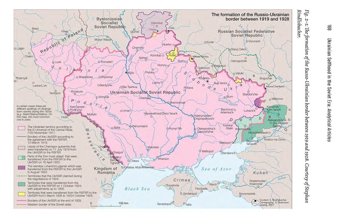
With the politburo's ultimate verdict at the end of 1924, the main lines for the prospective border between the UkrSSR and the RSFSR were set. However, additional fine-tuning took a considerably longer time. At the request of local inhabitants, the beginning of 1925 also marked the start of a series of minor adjustments that attempted to adjust the new boundary in favour of both Soviet republics. However, some cases continued to be disputed.
When Ukrainian intellectuals raised the issue ofthis unsatisfactory demarcation between the UkrSSR and the RSFSR during a debate with Joseph Stalin in February 1929, the Soviet leader was initially reluctant to address their concerns. However, on being pressed over the issue by his guests, Stalin eventually relented and informed them that: “We have discussed [the border question] several times; but we change borders too often [...].
Far too often we move the borders - this creates a bad impression both inside and outside our country.”1 In doing so, he effectively articulated the general line that would be used when dealing with border issues in the near future, viewing any changes to the Soviet Union's internal borders as nationalistic quarrels that would only lead to conflict while hindering socialist construction and industrialization. As a result, individuals or groups calling for intra-Soviet territorial revisions had to reckon with repression. Consequently, the limited debate and competition around territorial issues among state and party actors was, for a time, brought to an end.Western Expansion in the Course of the Second World War
In the end, however, Stalin's later foreign policy meant that the borders of Soviet Ukraine did not remain stable. Territorial annexations in the west at the end of 1939 were a direct result of Soviet expansionism in co-operation with Nazi Germany. Shortly before the German attack on Poland, the ideological arch-rivals Hitler and Stalin had come to an agreement, in a secret additional protocol to the Non-Aggression Pact, regarding their countries' respective sphere of interest. Finland, the Baltic states, and eastern Poland, as well as Bessarabia fell into the orbit of the Soviet Union. On September 17th, as the German Wehrmacht besieged the now isolated Warsaw, the Red Army invaded eastern Poland. Following a series of staged plebiscites, Eastern Galicia and Volhynia were annexed by the UkrSSR. At first, Soviet forces were welcomed by parts of the population, but this was soon to change due to the imposition of Stalinist policies on society and the local economy.
In June 1940, following the Third Reich's occupation of France, the Soviet government finally called on Romania to cede Bessarabia together with North Bukovina. Faced with the threat of war and the loss of its French ally, the Romanian government acquiesced to Soviet pressure.
About two thirds of the former Romanian territories subsequently formed the Moldovan SSR, while the remaining third was annexed by the UkrSSR. Soonafter, minor territories alongside the Dniester River were also transferred from the UkrSSR to the Moldovan SSR.In these newly annexed territories, the Soviet government ordered the rapid collectivization of agriculture with peasant resistance being met with state terror, particularly in western Ukraine. Consequently, German and Romanian troops were also initially welcomed follow the Axis invasion of the Soviet Union in 1941 with local Ukrainian peasants tending to lend their support to Nazi Germany against the Soviets. However, since the German leadership rejected a Ukrainian nation-state, Ukrainian nationalist co-operation soon dissipated. Following the reconquest by the Red Army in 1944, resistance to Soviet power in these western Ukrainian regions was especially well organized and fierce. The territory itself was not fully pacified until well into the 1950s with the guerrilla war in western Ukraine remaining a taboo subject for decades.
In the west, Carpathian Ruthenia also became part ofUkraine in 1945, an area that had previously experienced three changes of rule within 27 years. Until 1918, it had been part of the Hungarian portion of the Habsburg Monarchy before being transferred to the newly established Czechoslovak Republic. During its prolonged dismemberment from 1938 to 1939, however, a significant part of Carpathian Rutheniawas annexed by Hungary. However, with the Axis' defeat in 1945, the Soviet Union then claimed this area for itself leading to its subsequent occupation by the RedArmy. The Soviet leadership subjected the region to a special border regime, which severely restricted the inhabitants' freedom of movement. Moreover, although its eastern Slavic-speaking population saw themselves as rusyny or rus’ki, the Soviet authorities officially defined them as part of the Ukrainian nation. Despite the regime's efforts to weaken traditional identities, the region has therefore maintained a distinct cultural and linguistic position within Ukraine.
A final territorial change in the west of the UkrSSR occurred in 1951 when the Soviet Union and the People's Republic of Poland “exchanged” some 500 km2. In the area around the Polish border town of Belz (today Belz), a coal field had previously been discovered. The Soviet Union wanted to exploit this resource, offering Poland the hilly and war-ravaged region around Ustrzyki Dolne. The Polish government ultimately had to accept this unfavourable deal.
The town of Ustrzyki Dolne itself can be regarded as an example of the brutal population change that took place Eastern Europe during and after the Second World War. In the interwar period, the mixed Jewish-Polish-Lemko shtetl had been part of Poland. Many of its Polish residents were deported after the Soviet occupation in 1939, while the Jewish inhabitants had been sent by the Nazis to the extermination camps. In 1947, the remaining Lemko inhabitants were expelled to Poland by the Soviets. When the area became part of Poland once again in 1951, it was almost deserted.
Crimea and its Historical Belonging
Since the dramatic events of 2014, Crimea has drawn extensive international attention. During the interwar period, the peninsula’s territorial affiliation hardly played a role in the intra-Soviet debates on border revisions. At that time, it was characterized by an ethnically heterogeneous population. According to the 1937 census, around 45 per cent of this were Russians, 20 per cent Crimean Tatars, 13 per cent Ukrainians, 5 per cent Jews, and 5 per cent Germans. Additionally, the peninsula also featured small communities of Armenian, Greek and Bulgarian settlers. The Second World War not only brought widespread devastation, but also culminated in a dramatic process of ethnic un-mixing, comparable to what had transpired in Ustrzyki Dolne. During the war itself, many of the peninsula’s Jews fell victim to the Holocaust. Following its liberation, the Soviets accused local Germans and Crimean Tatars of having collaborated with the Third Reich and deported these communities to Central Asia. As a result, from 1945 to 1991, the remaining population of Crimea consisted mainly of Russians and Ukrainians.
Ruined and depopulated, the peninsula faced tremendous challenges after 1945 with the most burning economic problem being seasonal drought. However, at the beginning of the 1950s, the State Planning Authority, Gosplan, launched a major development project to ensure the irrigation of Crimea. By building a canal several hundred kilometres long, water from the Dnieper River would allow the dry soils of the peninsula to bloom. Advertising brochures even boasted that the canal would make Crimea a “land of plenty”. Economically and administratively, it therefore seemed reasonable to transfer the peninsula from the RSFSR to the UkrSSR.
With Stalin's death in 1953, his order that no further internal territorial transfers should take place were quietly dropped, prompting fresh rounds of revisions between the Union Republics. This was further prompted by the increasingly decentralized nature of economic planning with the republics regaining ever more control from Moscow. Against this background, the Supreme Soviet decided in February 1954 to transfer Crimea to Ukraine. In their explanatory statement, state and party leaders pointed to its economic prospects with Kliment Voroshilov, among others, emphasizing that “such a just solution of territorial questions among the republics is only possible under the conditions specific to the Soviet Union. This solution is grounded in economic efficiency and based on the full consent and fraternal cooperation of Soviet peoples.”2 In the press reports as well as in the decision of the Supreme Soviet, the transfer of Crimeawas presented as having been solely a matter of economic efficiency and not as kind of “gift” to Ukraine.
After 1954, Crimea's infrastructure became more and more linked to the UkrSSR with pipelines, canals, and electric power grids supplying the peninsula with energy and water from rest of the Republic. The North Crimean Canal, formerly completed in 1976, was a notable example, allowing for extensive agriculture on the peninsula and illustrating the extent to which both Crimea and the Ukrainian mainland could benefit from each other.
The period 1919 to 1954 was crucial to the formation of the Ukrainian state in the sense of territoriality. As this chapter has highlighted, this was ultimately the result of a series of complex negotiations that covered its north, east, and southern boundaries as well as a consequence of westward Soviet expansion during and after the Second World War.
With the collapse of the Soviet Union, Ukraine gained its independence in 1991 with its internationally recognized borders corresponding to those of Soviet Ukraine after 1954. Ukraine's territorial integrity was guaranteed by Russia, the United States, and the United Kingdom by the 1994 Budapest Memorandum in return for Ukraine's renunciation of nuclear weaponry. In the 2000s and early 2010s, Ukraine and Russia also agreed to accurately map and mark a common border, seemingly resolving any future issues between the two for good. In addition, in 2010, the government of Viktor Yanukovych extended the leases for the Russian naval base at Sevastopol' by a further 25 years.
The Russian government saw its geopolitical interests threatened with the violent change of government in Kiev in the spring of 2014. With the stroke of a pen, it ignored the many previous diplomatic guarantees by invading and annexing Crimea and supporting the secessionist republics in eastern Ukraine. In the case of Crimea and Donbas, since 2014 the war had devastating consequences for both sides. For instance, Ukrainian authorities blocked the North- Crimean Canal and the water access to the peninsula. Crimea is dependent on supplies by sea or via the Kerch-strait-bridge, which had opened in May 2018. Nevertheless, the peninsula suffered heavily from severe water shortages while the coal and steel industries in the Donbas subsequently underwent rapid decline.
After the all-out Russian invasion in February 2022, one of the first things Russian troops did was move to secure the North Crimean Canal's access to the Dnieper River and attempt to redirect the supply of water to the peninsula. Thus, the struggle for control over water and access to industrial assets - or in a broader sense economic issues - would continue to play a significant role in the Russian Federation's endgame.
Notes
1 Stenograph of Stalin's meeting with Ukrainian writers, February 12,1929, in: RGASPl, f. 558, op. 1, d. 4490, l. 19; LeonidMaximenkov, “Stalin’s Meeting with a Delegation ofUkrainian Writers on 12 February 1929,” Harvard Ukrainian Studies, 16:3/4 (1992): 361-431.
2 Kliment Voroshilov, “Address to the Supreme Soviet, February 19,” Pravda, 27 February 1954, p. 2.
Selected Bibliography
Eschment, Beate and Sabine v. Lowis (eds.) Post-Soviet Borders: A Kaleidoscope of Shifting Lives and Lands (London/NewYork: Routledge, 2022).
Gross, Jan Tomasz. Revolution from Abroad: The Soviet Conquest of Poland’s Western Ukraine and Western Belorussia (Princeton: Princeton University Press, 2002).
Hirsch, Francine. Empire of Nations: Ethnographic Knowledge and the Making ofthe Soviet Union (Ithaca: Cornell University Press, 2005).
Iefimenko, Hennadii. Wyznachenniakordonumizh USSRta RSFRR,” Problemy istorii' Ukralny 20 (2011): 135-176.
Magocsi, Paul R, With their Backs to the MountainsiA history ofCarpathian Rus’ and Carpatho-Rusyns (Budapest/New York: Central European University Press, 2015).
Martin, Terry. The Affirmative Action Empire: Nations and Nationalism in the Soviet Union, 1923-1939 (Ithaca: Cornell University Press, 2001).
Palko, Olena andArdeleanu, Constantin (eds.) Making Ukraine: Negotiating, Contesting and Drawing the Borders in the Twentieth Century (Montreal: McGill- Queen’s University Press, 2022).
Rindlisbacher, Stephan. “From Space to Territory: Negotiating the Russo- Ukrainian Border, 1919-1928,” Revolutionary Russia, 31:1 (2018): 86-106.
Sasse, Gwendolyn. The Crimea Question: Identity, Transition, and Conflict (Cambridge, Mass.: HarvardUniversity Press, 2007).