A decades-long naming dispute at the International Hydrographic Organisation centres on the body of water that straddles 40 degrees north latitude and rests between 130 and 140 degrees east longitude.1
Oceanographers refer to this sea as one of the northern Pacific Ocean’s ‘marginal seas’, and depending where you stand along its spiky coastline, its deep blue hues are variously known as the Sea of Japan, Korea’s East Sea or simply the East Sea.
This essay does not advocate one name in preference over another, while ideas for new names regularly appear. During the first decade of this century, for example, a Japanese woman thoughtfully suggested, ‘The Blue Sea’, while a former president of South Korea proposed the ‘Sea of Friendship’ or the ‘Sea of Understanding’.[550] [551] Agreement on a new name is remote, however, leaving international news broadcasters such as CNN to explain regional military tensions taking place in ‘waters off the Korean Peninsula’.[552]For millennia, a steady stream of human traffic has crossed over this sea’s northern and southern openings, largely from the Asian continent moving eastwards to what is now called Japan. Thus, the name East Sea originated as a directional term (literally, MW), with the first known
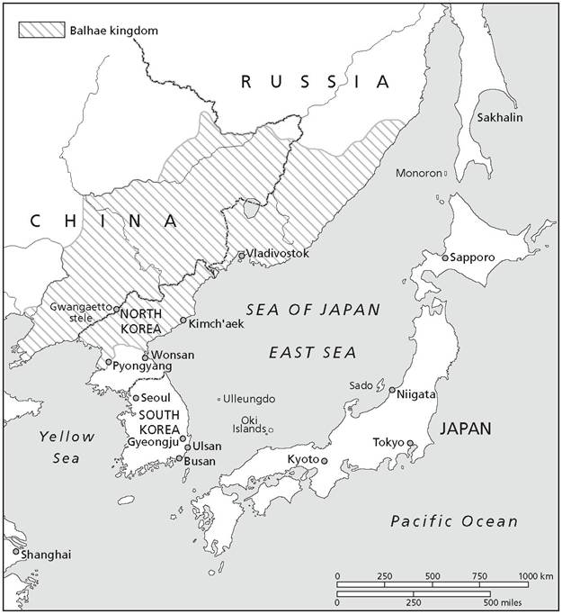
Map 7.1 The Sea of Japan/Korea's East Sea
written record of it carved into an early fifth-century stele commemorating the life of King Gwanggaeto the Great, the nineteenth monarch of Goguryeo, northernmost of Korea's ancient dynasties.[553] The first known reference to the East Sea as such outside of East Asia appears to have been in the thirteenth-century travelogue of Giovanni de Pian del Carpini, a contemporary and follower of Francis of Assisi who wrote one of the earliest European accounts of areas under Mongol control and contact.[554]
Although modern technologies have replaced earlier days of sail, intense north winds make this sea notoriously difficult to cross.
Most ancient navigators headed along its coastlines to the few straits that offered a better chance of safe passage: the Korea or Tsushima Straits, the Kanmon Straits, the Tsugaru Straits, the Soya or La Perouse Strait, and the Strait of Tartary. Very little river water discharges into this sea - barely 1 per cent of its volume - and today places called Russia, North Korea, South Korea and Japan contain its 978,000 square surface kilometers. Russia claims almost half of this sea’s total 7,600-kilometer coastline even though Russian explorers were the last to show up in the region. Their seventeenth-century designation for the sea - the Japan Sea - named the area to which they were heading and appears to have relied on or was coterminous with Matteo Ricci’s 1602 map of the world, that - for the first time historians are aware of - designated this body of water in Chinese characters as ‘ 0ĆĆ’ (Japan Sea).[555] Notably, the ‘Japan’ piece (0Ć) as understood in European translation derives from Marco Polo’s famous thirteenth-century phonetic transliteration of China’s name for the country: ‘Ciapangu’ (as it appeared verbatim on Martin Behaim’s astonishing 1492 globe). The word ultimately Europeanised as Giappone in Italian, Japon in French and Yaponskey in Russian, as it would thus appear to name the sea on seventeenthcentury Russian maps: ßďîíńęîĺ ěîđĺ (Yaponskey More). There seems to be no evidence that any Japanese used the name Sea of Japan in print before the late eighteenth-century until the painter and illustrator Shiba Kokan printed it on his 1792 map of the world (the famous ‘Chikyu Zenzu’: ąf^^l3).[556]In 1928, when the International Hydrographic Organisation agreed to Japan’s request for the sole name, ‘Sea of Japan’, Korea could not object because it was under Japanese occupation. That said, the collection of early modern European maps that current international arbitration tribunals favour seem equally divided between references to the Sea of Japan and East Sea/Korea's East Sea.
Thus, Korean geographer Ryu Yeon-Taek explains that the Korean government today prefers a dual naming scheme for this sea until all parties involved - including Russia and indigenous groups - settle on an alternative new name.[557] The most famous of the early modern European maps is French count of La Perouse, Jean-Francois de Galaup's 1797 map of his explorations of the northern Pacific - known widely as the ‘La Perouse Map' - which shared the ‘Sea of Japan' terminology with Matteo Ricci's 1602 map of the world and that of numerous Russian explorers as well. At the same time, different European mapmakers chose otherwise: British Royal Geographer, James Wyld, printed ‘Sea of Korea' on his 1823 map, Dutch engraver, Peter Schenk the Younger, used ‘Mare Orientale' (East Sea) on his 1708 map, and Dutch publisher Pieter van der Aa chose ‘Mer de Coree' (Korean Sea) for his 1706 publication (the European term for Korea deriving from awareness of Korea's Goryeo Dynasty [9181392]).[558] Of note, for his part, the renowned French cartographer Gilles Robert Vaugondy's splendidly colourful 1750 map, ‘Empire du Japon', used two names: ‘Mer du Coree' and ‘Mer du Japon'.[559]Any Neolithic-era name that may have been in play among the indigenous Nivkh, Orok and Ainu people - whose few descendants still live along the thin stretches of water where mainland Russia breaks off towards Sakhalin Island - failed to make the grade of modern maps, although they treasure their ancestors’ boots and clothes made of salmonskin hides. Fishing formed the basis of these communities’ existence, and at least for the Ainu, a god of the sea that storytellers call Repun appears in drawings either as a whale or as a male figure with a harpoon. Legend relates tales of Repun’s beneficence in fish catches when the hunt on land was meagre, yet none of the storytelling groups seems to have had a specific name for the ocean that Repun makes bountiful, nor, however, did they have writing.11