Modelling Environmentally-Constrained but Adaptable Society-Environment Systems
8.3.1 TEM (“Terroir”-Based Environmentally Constrained Models)
Following our classification, we describe here the “terroir” level models, where a society and its evolution is driven by their calorie and resource demand and constrained by environmental parameters.
Important information used for the model originates in archaeology, such as tools and practices; knowledge on environmental factors is also important.As an example of these models, Baum (2014) has formalized a GIS-based object model based on information from available and relevant literature and local archaeological data regarding environmental characteristics (soil, vegetation, local climate, distance to village) and cropping and livestock-keeping practices, to evaluate the environmental impact of human settlements over several village territories, along several farming scenarios (shifting, intensive garden and non-intensive cultivation) and diet assumptions (Fig. 8.1).
Further works with similar research interests include Coolen (2010), who has worked over different sites of the LBK (Linear Band Keramik) culture territory in Europe: thanks to a systematic geographical census of the archaeological sites of the LBK culture over a region, the agro-ecological characteristics of the implantation sites of this culture (pedology, climate, orientation, hydrology, relative distance to other sites) can be statistically determined. Combined with estimates on economic and agriculture-related parameters of this agropastoral system, this methodology aims at establish a spatial discrimination of a territory along site preferences and potentialities according to a specific culture agropastoral habits.
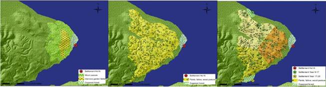
Fig. 8.1 Three “snapshot models” illustrating the model design in (Baum 2014). Economic areas are calculated using various hypotheses and their extent modeled in a GIS.
LEFT: Intensive Garden Cultivation is applied, resulting in permanent, fields and “extra” wood pasture (light green); CENTER: Shifting Cultivation is applied, a large area is affected in 25 years. The resulting area exhibits elements of fallows, coppiced stands, and livestock browsing areas side by side. RIGHT: Two hypothetical settlements (green and yellow) have been added, and a relocation of the sites is assumed after 8 years. This might reduce maximum travel distances for agricultural activitiesThis methodology is equivalent in Burke et al. (2008); Tipping et al. (2009); Graves (2011); Carrer (2013). For instance, Yu et al. (2012) test on the Yiluo valley a combination of demographics and agriculture-based extrapolations and social assumptions based on what archaeology but also modern information provides.
Following their work on Swiss and German archaeological sites, Ebersbach and Schade (2004) have studied livestock-keeping needs and consequences on sustainability of environmental resources and livestock-based farming societies: through a GIS, they have estimated the impacts on an extended village territory of the necessary livestock to both feed the population and manure the fields that are necessary for crop production for feeding a population.
The research object of all these simulations is the area or the evolving landscape; the major tool is GIS input data comprise archaeological and paleo-environmental information. However, because the subject, i.e. the research question, differs, they are representative of the “discipline-as-input” factor differentiation: Coolen (2010) used environment as input and deduced site potentialities, with the hope that further archaeological excavations may provide confirmation. Baum (2014) and Ebersbach and Schade (2004) used archaeology as input and deduce the impact on the related territory and natural resources following various scenarios. These approaches are used to test the relevance and implication of certain model parameters, such as the crop husbandry or the size of the economic territory They set up spatial hypotheses which serve for explanatory purposes and as a reference plane for future works.
The strength of such models is to estimate the constraints in which agro-socio-systems may evolve using local data and archaeological and/or agro-environmental assumptions on economic activities. Meanwhile, many of them establish the maximum potential level, i.e. a carrying capacity equivalent in those specific conditions and techniques such a society may reach, but not its fragility regarding social variables and temporal “coincidences” that are inherent to every society.8.3.2 WEM: “World” Size Environmentally Constrained
Models
Modelling prehistoric and pre-industrial society-environment systems is essential to understand the co-evolution of climate and humans over recent Millennia as well as the current state of the earth system. Such an analysis should be settled at the global scale, simply because it is the sole relevant scale for apprehending human-induced climate changes. Many of the ecosystems that are highly valued today for the services they provide to humanity are the result of long-term interactions between society and their environment. Because detailed observations of these interactions will always be limited in space and time, global human-environment models may be useful tools to bridge spatial and temporal gaps in data and to test hypotheses about the large-scale development of society and the environment.
Despite its promise, global modelling, however presents several additional challenges compared to the “terroir scale” described above. The foremost among these challenges concerns data both for driving the models and for evaluating their output. Outside of Europe and parts of East Asia, critical information on subsistence lifestyles, the timing of key transitions, and on paleo-demography needed to parameterize models is not available because of a lack of investigations in these regions or a poorly preserved archaeological record. Likewise, palaeo-environmental and ethnographic information, that is highly valuable for model evaluation, is largely absent from many continents where geographic conditions and local history led to poor preservation of archives, both natural and human.
Regarding the three points described in Sect. 8.2.4, WEM-type models obviously meet the spatial genericness criterion (1) but they methodologically do not completely fulfil the criterion (2) regarding time: rules of the model do apply all along simulations but the model lacks time-related adaptability. Finally, the criterion (3) is not answered as such models do belong to the ii. (b) palaeo-environmental “Disciplines used as inputs and drivers” scheme meaning that changes are environmentally driven.
Nevertheless, there are several promising methodologies that are currently being applied to understand society-environment systems at global scale. These models may be roughly divided into two categories:
• data-driven approach where demographic and subsistence data are inputs to the model;
• an “organic” approach, where the model simulates potential human population and subsistence lifestyle as prognostic variables. Both of these approaches have advantages and disadvantages and are currently under rapid further development.
The data driven approach is typified by the ALCC scenarios KK10 (Kaplan et al. 2009, 2011) and HYDE (Klein-Goldewijk et al. 2011). These scenarios are the result of empirical models that take geographically distributed estimates of population at any time in the past and combine them with information on climate and soils in order to estimate the magnitude and spatial distribution of land use. The models used to generate these scenarios assume subsistence lifestyle implicitly, i.e., everyone on earth at a given time is presumed to have the same type of subsistence strategy. While HYDE makes a simplistic distinction between land use for crop or pasture based upon present-day geographic patterns of land use, it does not consider changes in per capita land use over time (intensification). In contrast, KK10 models intensification as a non-linear function of population density itself, so that low population densities use relatively large amounts of land.
This difference in the representation of per capita land use among the models leads to very large differences in the global pattern of land use in the past (Fig. 8.2).As noted above, neither model takes directly into account the way in which different subsistence lifestyles may use the same landscape, e.g., foragers versus shifting cultivators versus permanent agriculturalists versus pastoralists. This distinction among land use types, in particular the shift from foraging to farming, may be critical
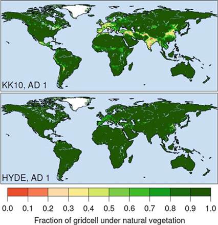
Fig. 8.2 Comparison between global anthropogenic land cover change scenarios KK10 and HYDE for the year AD 1. The large discrepancy between the scenarios in the maps is caused by differences in the treatment of per-capita land use. HYDE fixes the spatial pattern of per-capita land use observed in AD 1961 for all time periods in the past, whereas KK10 models per-capita land use as a function of population density, with intensification occurring at higher densities (courtesy of J. Kaplan)
for understanding the pattern of land cover change and human impact on the environment during pre-industrial time. While the agricultural transition could be prescribed in models based on archaeological records, lack of investigations or well-preserved sites implies that in many parts of the world prescription would be based on guesswork or assumptions. An alternative approach is to use a model that explicitly simulates subsistence lifestyle changes, as in the “organic” approach mentioned above.
Currently the best example of this approach that has been developed and applied at continental to global scale is the GLUES model (Global Land Use and technological Evolution Simulator (Lemmen et al. 2009). GLUES simulates human population density, technological change and agricultural activity directly, based on the concept of gradient adaptive dynamics, where adoption of a subsistence lifestyle, e.g., Neolithic agriculture, by any given group of people at any particular time depends on endogenous environmental and social factors, e.g., potential productivity, population density, and exogenous factors, including the presence of farming people in neighbouring regions.
Simple rules in GLUES, including continent size and climate, allow the model to simulate the spontaneous transition to farming in certain regions of the world (Wirtz and Lemmen 2003). Once farming is established, the model simulates the advection of peoples and diffusion of ideas and technology across environmental gradients. The GLUES model is driven by static maps of potential productivity and climate on regions of ca. 1000 km2 that are defined as areas of relatively homogeneous climate and productivity. GLUES can further use information on climate variability prescribed as discrete events in space and time to influence human activities and populations. GLUES' prognostic outputs include population density, relative proportions of farming people in the region, and the level of technology used by the farming people. The major disadvantage of GLUES is that it may produce histories of society-environment interactions that are at-odds with reality, e.g., the spontaneous development of agriculture in places where it is not known to have occurred. Additionally, GLUES in its current form cannot simulate major technological transitions beyond the initial adoption of agriculture, e.g., metallurgy, urbanization, or the development of complex societies, with focuses on specific sites such as Western Europe (Lemmen et al. 2011) or the Indus civilization (Lemmen and Khan 2012).Such models answer the criteria (1) and (2) with a formal justification of the appearance of such technical innovations (Lemmen 2012). More globally, they cannot answer the criterion (3):
• Social innovations, such as socio-anthropological family evolutions and/or political structures, are less likely to be modelled, while such social innovations may have a determining impact on the “capacity” of a society for conquering new territories, following non-Malthusian hypotheses (Boserup 1965, 1976; Lemmen 2012). For instance, Todd (2011) has suggested large variations of the family structures in Eurasia, linked with the appearance of unequal families and the consequences on the cultures’ differential “capacity” of expansion.
• The effects of “coincidences”, i.e. emergences may disappear as such conjunctions are smoothed while going at a broader scale, both socially and spatially.
8.4
More on the topic Modelling Environmentally-Constrained but Adaptable Society-Environment Systems:
- Modelling Past Rural Environment-Society Systems
- Simulating Economic, Social and Cultural Change in Prehistory. Why Humans Have Made Life so Complex and Difficult