17 Tin Traders
I
By the second half of the first millennium bc the Atlantic arc had ceased to function as a lively network binding together distant parts of the west European coastline; it became the outer margin of a new world whose main centres of activity lay in the heartlands of continental Europe.
This was the age of the two successive cultures known as Hallstatt and La Tene that interacted strongly with the peoples of the Mediterranean, such as the Etruscans, and became masters of iron production. Iron remained largely out of favour along the Atlantic edges, probably because it was not as readily available as it was in central Europe; but this itself indicates how the coastline had become disconnected from developments in the hinterland.1 When Etruscan bronze figurines turn up in Devon, Greek coins appear in Brittany or Iberian pin-brooches (fi bulae ) are found in Cornwall, this is an exciting event in archaeology, for after 500 bc such exotic items had become increasingly rare; and it has been seen that the apogee of the Phoenician penetration into the Atlantic, judging from the case of Mogador, can be dated to the sixth century bc.2Sea traffic certainly did not cease; but some of the most impressive connections, such as that linking Orkney to the Irish Sea and beyond, either were sundered or became much less regular, to judge from the very limited finds of ‘foreign’, that is, non-Orcadian, goods on Iron Age sites within the Orkney archipelago. As along the shores of the Scottish mainland, the coasts of these islands were now dotted with small castles, or brochs, whose function is as much a mystery as the Sardinian nuraghi, to which they bear an outward resemblance.3 Like the nuraghi, they were often surrounded by small outhouses, and became the nucleus of village settlements. Indeed, stone roundhouses, not quite as imposing as the broch towers must have been, characterized settlements all along the Atlantic arc, from Portugal to Shetland.4 More generally, there is a sense that
society was turning inwards, and that local communities lived off both the land and sea.
In the British Isles these communities based themselves in small settlements that it would be hard to dignify with the title of town, though that would be a suitable description of several of the large settlements that have been discovered along the maritime edges of Galicia and northern Portugal. Brittany may also have possessed a few imposing settlements close to the sea. Writing about his invasion of north-western Gaul, Julius Caesar described the settlements of the Veneti in Brittany as ‘towns’, but he wanted to impress his readers with the scale of his conquests. It would not have sounded quite right if Roman armies had had to struggle to master scattered seaside villages.Evidence for exchange of goods across the sea is so sparse that the argument for contact up and down the coasts of Atlantic Europe has to depend on cultural similarities all the way from Portugal to northern Scotland. There were broad similarities in the decoration of pottery; there was the common practice of building villages made up of roundhouses constructed on stone foundations. The similarities between the culture of Brittany and Cornwall, and their difference from the rest of France and England, suggest that the links across the sea should not be underestimated.5 Between about 600 and 200 bc, a striking common feature across great swathes of the Atlantic coastline was the construction of promontory forts overlooking the sea; these were lines of walls, generally double or triple lines, that cut off the tip of a small promontory. There is no certainty about their function. It is unlikely that they marked out trading centres, because they are by and large in elevated positions and not close to an obvious harbour. Excavation of the promontories has produced little evidence that they were continuously inhabited. More likely, they were places of refuge and strongpoints to which warriors and their dependants could retreat in times of war. Julius Caesar described the defensive use of promontories in Brittany in his Gallic Wars :
The positions of the strongholds were generally of one kind.
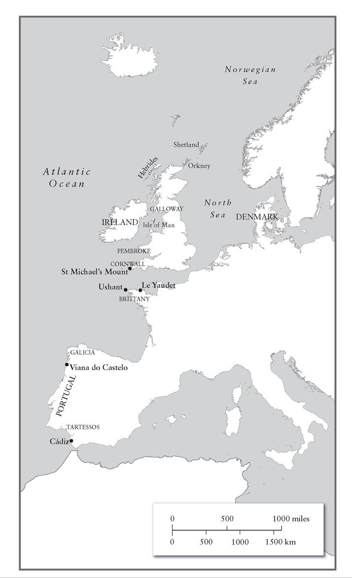
They were at the end of tongues and promontories, so as to allow no approach on foot, when the tide rushed in from the sea - which happens every twelve hours - nor in ships, because when the tide ebbed again the ships would be damaged in shoal water.6On the other hand, they could not all benefit from the tide this way. They generally looked out to the west, from western Ireland, Galloway in southwest Scotland, or the Pembroke peninsula in Wales; they were abundant in Cornwall and Brittany, and they appear on the islands of the north Atlantic: Shetland, Orkney, the Hebrides and the Isle of Man.7 This suggests that they may sometimes have had a religious rather than a defensive use, as points of land on which to propitiate a god of the sea or of the winds, bearing in mind that the prevailing winds came from the west. Another common feature of the northern Atlantic coastal communities was what are known as souterrains, underground corridors built out of stone with some care; and, once again, their function is unclear - maybe they were for storage, maybe for shelter, though they would have been clearly visible above ground, so it is hard to see what advantage that would have brought. Once again, it is the presence of the same subterranean architecture on both sides of the English Channel that suggests mutual influences, rather than any objects found in the ground.
Settlements of varying size made up of roundhouses could be found as far south as Iberia. The castros or citanias of Galicia and Portugal were often substantial settlements occupying good strategic locations. One example is the very substantial citania at Santa Luzia, high above the modern Portuguese town of Viana do Castelo; unfortunately, a large part of the site was destroyed early in the twentieth century in order to build a luxury hotel, but more than enough remains to indicate that the term ‘town’ rather than ‘village’ would be appropriate here. It overlooked the River Limia where it debouches into the Atlantic; this was a superb defensive position.
Whether the inhabitants made much use of their access to the Atlantic is unclear. The site at Santa Luzia eventually acquired three lines of walls; the area within the walls contains dozens of circular houses closely packed together, as well as solid towers built into the retaining walls. The houses, several of which contained vestibules, were entered from the south-west or the south-east, since a southerly entrance was better sheltered from the winds and rain that tended to strike from the opposite direction. While the walls were of stone, the conical roofs of these houses would have been built of wood covered with straw. Loom weights have been found, indicating that weaving was a local industry, as one might expect; otherwise, the main sources of livelihood were agriculture and stock-raising.8Bearing in mind the cultural similarities between the roundhouse settlements all the way from Portugal to the Scottish isles, the question then arises whether the inhabitants of these places possessed a common origin. Some archaeologists and philologists have seized on the idea that what united these people was a ‘Celtic’ identity. Language and race are quite different things, and people of similar ancestry switch languages, so that it becomes impossible to identify the ‘original’ language of those groups. Indeed, the term ‘Celts’ has several plausible meanings: the peoples called Keltoi by the ancient Greeks, and Galli by the ancient Romans; the assumption that the Hallstatt and La Tene cultures in central Europe were essentially ‘Celtic’ in character; the peoples who spoke Celtic languages, several of which survive to this day.9 A case has been made for the use of Celtic dialects not just in Scotland, Ireland, Wales and Brittany but in Galicia. Its modern inhabitants have seized on their ‘Celtic’ identity in the struggle to gain greater autonomy from the government in Madrid, though whether a modern-day fondness for bagpipes proves Celtic identity is a moot point.
Beyond that, in south-western Iberia, in the lands rich in silver visited by the Phoenicians, lay the area known to the Greeks as Tartessos.A significant number of Tartessian inscriptions survive, written in a distinctive script whose remote origins probably go back to the same Phoenicians. If, as John Koch has controversially maintained, they are written in a Celtic language, that only mildly reinforces the argument that the lands of the Atlantic arc shared a number of cultural traits, as well as being somewhat isolated from the cultures of the rest of western and central Europe. It would be good to know that talainon really does mean ‘the country of the blessed headland’, an ambitious extrapolation from a protoCeltic term assumed to mean ‘having a fair brow’, but with such limited material these efforts at decipherment appear far-fetched.10 On the other hand, a general case can be made for the archaic character of the form of Celtic, known as Q-Celtic, spoken in Ireland and then, partly as a result of later Irish settlement in Scotland, in the far north of Britain as well; and this would imply that in the first millennium bc an ‘Atlantic protoCeltic lingua franca’ was a feature of a common culture that flourished around the Irish Sea and at least as far south as Brittany, only to be overtaken in Wales and Cornwall, and later on in Brittany, by more recently formed languages that are known as P-Celtic and that were closer to the languages spoken by the ancient inhabitants of Gaul.
Knowing who these people were is certainly desirable. To what extent they saw themselves as people wedded to the sea is uncertain, but it is interesting that the term ‘Armorica’, a latinization of the ancient name for Brittany, means ‘dwellers by the sea’. Some of the peoples encountered by Julius Caesar during the Roman war of conquest in Gaul (58-50 bc) were excellent navigators. A famous passage in Caesar’s boastful memoir of his victories, mentioned already, describes the ships of the Veneti of Armorica, which he encountered in 56 bc.
They are said to be built quite differently from Roman ships: they have much flatter keels, because they have to deal with tidal waters where the water level changes significantly; they have high prows and sterns, to carry them through rough seas and storms; they have strong cross-beams bolted together with thick iron fastenings; they are made of stout oak that can tolerate the violence of the open sea; they have anchors suspended from iron chains; their sails are made of hides; altogether they are much better suited to the mighty winds and waves of the open ocean than Roman vessels.11There were also smaller vessels that were strong enough to withstand the waves. At the end of the nineteenth century an Irish farmer ploughing his field at Broighter in County Derry turned up a hoard of gold artefacts dating from around the time of Caesar’s wars in Gaul, or maybe a little later. The most remarkable piece the farmer found was a miniature boat, twenty centimetres long, and modelled in gold with loving detail. The model contains nine benches for oarsmen, and eighteen delicate oars, as well as a steering oar at the stern, a mast and an anchor (or grappling hook). It has been estimated that a boat built to this specification would have been 12-15 metres long.12 Boats of this type were constructed out of wickerwork that was fitted around a wooden frame; all this was then covered with skins and coated with animal fat to create a solid waterproof vessel. They have been constructed around the world from prehistoric times to the present day, and include circular Mesopotamian rivercraft, Welsh coracles (also circular) and Irish currachs, of which the gold model is a very ancient example.13 Caesar’s description of the sturdy Venetic ships offers powerful evidence that the Atlantic coastline was indeed connected by sea. And to the evidence of Caesar can be added that of Greek travellers, notably the intrepid Pytheas of Marseilles.
II
It is no surprise that the Greek travellers who became interested in the Atlantic should have had close links to Massalia, the port now known as Marseilles that had been founded by migrants and merchants from Phokaia in Asia Minor. They had, according to rather dubious accounts, fled from the conquering army of the Persian Great King, and then from a colony they had established in Corsica, out of which the Etruscans and Carthaginians flushed them in a great naval battle in 541 bc. Southern France was already the target of Etruscan traders, who made contact with the Gauls in the interior, selling them prodigious amounts of wine from the mid-seventh century onwards. Massalia experienced a golden age in the sixth century, because it was able to service demand in central France for wine and other Mediterranean goods, in the lands characterized by the so-called Hallstatt culture, which was dominated by powerful princes wealthy enough to acquire Mediterranean goods, long seen as a great marker of status. But then the focus of economic activity, and presumably political power, shifted eastwards within central Europe towards the scattered villages of the La Tene culture, around 500 bc, and Massalia lost its special advantage, though it has never ceased being a significant centre of trade.14 While the Massalians certainly exploited the land routes across Gaul and the river route up the Rhone, their skill at navigation made them curious about the lands that lay beyond the Strait of Gibraltar and the Phoenician base at Gadir; and what attracted them above all was the possibility of gaining privileged access to tin, which was required for the production of bronze goods - bearing in mind that the coming of iron had in no way depleted demand for bronze, as can be seen from the large number of bronze figurines and utensils being produced at this time within the Mediterranean (such as the massive Greek crater which arrived at Vix on the Seine in central France, perhaps as early as 530 bc).
Around this time an unnamed Greek sailor compiled a sailing manual, or Periplous, that described the coasts of Spain from Galicia through the Strait of Gibraltar along the coast all the way to Massalia. Today, it is a major source of information about Greek knowledge of the Atlantic, just as in its own day it was evidently treasured for its account of both Atlantic and western Mediterranean waters. Indeed, it was still being read in the late fourth century ad, when Avienus, a very indifferent pagan poet living in north Africa, based much of his work entitled The Maritime Shores (Ora Maritima ) on this Periplous; and without Avienus, whose work was published by a Venetian printer in 1488, the text would now be lost.15 It is a sort of palimpsest, as one has to scrape beneath the clumsy Latin to ascertain the views of the ancient Greek traveller. This is not too difficult, as he omitted several places that later became important, which inspires confidence in the very early dating; at the same time, his insistence that several ports were already in decay provides evidence, confirmed by archaeology, that the Phoenician network in the Atlantic had already passed its apogee.16
The original Greek author’s account of the lands where tin could be obtained was especially precious to the inhabitants of Massalia in the sixth century bc.17 Avienus spoke at length about Tartessos, which had also passed its peak by the fifth century bc, and confidently and incorrectly identified it with Cadiz (‘here is the city Gadir, formerly called Tartessos’), while insisting that ‘now it is small, now it is abandoned, now a heap of ruins’;18 he described how the Tartessians traded with their neighbours, and how the Carthaginians reached these waters; he pointed out a glittering mountain rich in tin which would have greatly interested early traders.19
Tin and lead, Avienus related, were also the great asset of a group of widely scattered islands known as the Oestrymenides that lay beyond a great promontory and that some commentators have identified with Great Britain and Ireland. However, a good case can be made for identifying this place with Galicia, which is surrounded by a number of offshore islands and was, it has been pointed out, ‘the most prolific tin-producing region in Europe’.20 Most probably, Avienus was drawing together disparate material and, having heard about tin supplies coming from Cornwall, Brittany and Galicia, was conflating all these into the Oestrymenic islands and mainland. Avienus’ traveller was impressed by the inhabitants:
There is much hardiness in the people here, a proud spirit, an efficient industriousness. They are all constantly concerned with commerce. They ply the widely troubled sea and swell of monster-filled Ocean with skiffs made of skin. For these men do not know how to fashion keels with pine or maple wood. They do not hollow out sailing vessels, as the custom is, from fir trees. Rather they always marvellously fit out boats with joined skins and often run through the vast salt water on leather.21
The poem also described how the ‘holy island’ inhabited by the Hierni lay a two-day journey from the tin islands, while ‘the island of the Albioni’ stood close by as well - these were evidently references to Ireland and Great Britain, and Avienus believed that the Carthaginians and the Tartes- sians used to trade as far as the Oestrymenides.22 Particularly mysterious is what then follows, an account of the wider spaces of the Atlantic Ocean that had supposedly been explored by a Carthaginian navigator, Himilco; Avienus described sluggish seas and windless days, as well as waters blocked with masses of seaweed. In general, though, Avienus’ account of the Atlantic, as one might expect from a Mediterranean author, emphasized the high waves, the strong winds and the marine monsters that would be encountered by anyone daring to venture into the ocean. There were inhospitable islands and there were miraculous places such as the isle of Saturn, which was thickly covered in grass but possessed a strange natural force: if any ship approached, the island and the sea around it would quake violently.23
Avienus did know of a route down the coast of Portugal, past Cape St Vincent: ‘rising high where the starlight sets, this extremity of rich Europe extends out into beast-filled Ocean’s salt water.’24 ‘That’, Avienus said, ‘is the Ocean which pounds the far-flung world. That is the great deep, this is the swell that encircles the shores. This is the supplier of the inner salt water, this the parent of our sea.’25 This was a Mediterranean perspective on the stormy, tidal Atlantic. The sailor from whom Avienus derived his material had evidently experienced a frightening but highly educative voyage towards the lands of tin. He deserves the title pioneer at least as much as the better-known, but not much better-recorded, fourth-century Massalian who followed in his footsteps and then ventured even further, Pytheas of Marseilles.
III
Pytheas was both an explorer and a writer. Since they had to rely on his own words, composed around 320 bc, later Greek authors whose description of the world ventured into the Atlantic felt themselves free to scorn what he said; they included Polybios, a serious historian who wrote in the second century bc, and Strabo, an equally serious geographer, who wrote in the early first century ad. Much that needs to be said about Pytheas has to be filtered through their hostile comments, and through remarks by Pliny the Elder, active a little later than Strabo.26 In the face of his classical critics, two modern historians of ancient exploration have boldly claimed that Pytheas ‘has the best claim among ancient travellers to rank with the great discoverers of modern times’.27 He has even been described as ‘the man who discovered Britain’, though Avienus’ traveller knew about Britain centuries earlier.28 The problem is that Pytheas’ own writings have vanished; too many people simply refused to take him seriously. He was accused of ‘errant deception’.29 Strabo and Polybios agreed that Pytheas’ voyage was simply implausible: ‘how could it happen that a private individual, and a poor man at that, could cover such distances by ship and by foot?’ Pytheas claimed to have reached the ‘limits of the cosmos, which a person would not believe if Hermes himself were speaking’.30
Pytheas’ motives for travelling as far as Britain, and maybe still further, might seem obvious. He shared a curiosity about the shape of the habitable world with his later rivals Eratosthenes and Strabo. This was the age of the great Alexandrian cosmographers. Even in faraway Massalia some of the major Greek works of historia (meaning ‘enquiry’) must have been known and read, not least Herodotos’ account of the Persian Wars, which also contained rich descriptions of barbarian lands, such as the territories of the Skythians to the north of the Black Sea. Then there is the possibility that Pytheas was keen to promote trade, or at any rate to identify places where useful trading connections could be made. It has been seen that, with the rise of the La Tene culture north of the Alps, trade routes carrying Greek and Etruscan goods through southern France had shifted eastwards, to the advantage of Etruscan and Greek towns in northern Italy and the upper reaches of the Adriatic. There was still strong demand for their goods in continental Europe, but the problem was that it was the wrong part of continental Europe from the perspective of Massalia. It has therefore been suggested that Pytheas set out with a grand fleet to break the Carthaginian monopoly on the Atlantic tin trade; but it seems much more likely that he was a lone traveller, and it was precisely because he was alone that he could range so far and wide and collect information about places, distances and products that would be precious to his compatriots.31 Moreover, there was always a question about where to turn for supplies of tin. The rocky promontories of northern Europe, in Brittany and Cornwall, beckoned.32
Despite the chorus of disapproval led by Polybios and Strabo, there is no reason to doubt Pytheas’ claim to have travelled at least as far as the British Isles during the fourth century bc, setting out from Marseilles. Nor is there reason to doubt that he made use of local ships rather than fitting ships out at his own expense. Ships powered by sail and oar were well suited to coastal navigation in the Mediterranean; but it is impossible to imagine a trireme battling against the high seas of the Bay of Biscay and the English Channel without it being rapidly swamped and sunk.33 A further complication was that during the fourth century bc the Carthaginians controlled key points along the coastline of Mediterranean Spain, and it is unlikely they would have waved a Greek ship past the great rock of Kalpe, later known as Gibraltar.34 Although Pytheas apparently knew about Kalpe and Cadiz/Gadir, whose existence was common knowledge in Massalia, it is much more likely that he followed a mainly overland route from Massalia to the Atlantic coast of Gaul, and went on board a Gaulish vessel there. After all, these land routes out of southern France were as much a part of Massalia’s rationale as the sea routes linking the city to Italy, Spain and the Mediterranean islands. Barry Cunliffe has suggested that he did indeed set out by sea from his home town, but only travelled a short distance: in his view, he passed the Greek settlement at Agde in what is now southern Languedoc and then arrived at Narbo (Narbonne), a ‘native port’; from there he would have headed to the river system that debouches into the ocean near the Gaulish settlement of Burdigala, or Bordeaux. The journey this far might only have taken a week.35
After three days at sea he reached Ouexisame, or Ushant, off the western tip of Brittany, but what he did there, or even whether he stayed for any length of time there, is pure speculation. Cunliffe places him on the north shore of Brittany, in the handsomely defended Iron Age port of Le Yaudet, at the point where the River Leguer joins the sea; this was a centre for trade across the Channel to southern Britain.36 There is no evidence Pytheas ever went there, but, if he had done, he would have experienced a strong contrast between his bustling home city of Massalia, with its imposing stone temple facades and its grand covered marketplaces, and any port along the coast of northern Gaul or southern Britain. This puzzlement at the more primitive life of the northern peoples is reflected in a romantic account of the simple lives of the early Britons, written by the Greek author Diodoros the Sicilian in the first century ad and possibly derived from Pytheas’ own book, On the Ocean. ‘Far removed from the cunning and knavishness of modern man’, they lived in wattle-and-daub huts and ate a thick gruel made from the ears of the grain they grew. Diodoros’ image of simple innocence formed part of a great literary tradition celebrating poverty rather than the corruptions of wealth that survived into the Middle Ages and Renaissance.37 The peoples encountered on these Atlantic travels were not derided for their simplicity, which was, rather, seen as very praiseworthy.
The Channel ports were a vital link in the tin trade that reached all the way from Britain to the Mediterranean. An account of the tin trade in south-western Britain also survives, once again from the hand of Dio- doros, and possibly echoing the lost words of Pytheas.38 Diodoros described a promontory called Belerion where seams of tin could easily be quarried. The tin was worked into the shape of knucklebones, and then it was carried to an offshore island named Ictis that was linked to the mainland by a natural causeway which flooded at high tide. Whole wagonloads of tin were taken across to Ictis at low tide and the tin was sold to merchants, who brought it first across the Channel to Gaul, and then overland all the way to the mouth of the River Rhone, whence it would presumably have been ferried to Massalia. Pliny provided slightly different information, calling the island Mictis, and stating that the Britons took their goods there in wicker boats covered in skins rather than across a causeway. One possible location for Ictis is St Michael’s Mount, off the coast of Cornwall, though no remains from that period have been found that might confirm the story.39
Even more speculative is Pytheas’ route northwards along the coasts of Britain as he island-hopped his way towards the edges of the known world on British boats. In trying to work out where he went, everything depends on measurements of the height of the sun at midday, cited (often scathingly) by his later readers such as Strabo. Strabo himself misjudged the orientation of the north European lands, even placing Ireland to the north of Great Britain, whose east coast in his view lay parallel to northern France and the Netherlands; but Strabo had an eccentric view of Ireland, which he saw as the very edge of the world, ‘just barely habitable’.40 The difference between Pytheas and Strabo, of which Strabo was keenly aware, was that Pytheas had visited most of the lands he described, while Strabo was an armchair traveller. One good candidate for a stop on Pytheas’ route is the Isle of Lewis, off the north-west shore of Scotland; and Pliny offered a very brief description of the Orcades, or Orkney archipelago, which he perhaps derived from Pytheas.41 But the big question is how far he travelled beyond that. Pliny repeated Pytheas’ claim that an island called Tyle lay six days’ voyage north of Britain, in a part of the world where the sun was hidden from view for half the year and continuously in view for the other six months (rather an overstatement of the phenomenon of the Midnight Sun).42 No part of Pytheas’ journey has attracted as much attention as his visit to what the dramatist and thinker Seneca would later call ‘Ultima Thule’, conjuring up the image of a remote and uninhabited land at the very edge of the world. Strabo refuted the claim that Pytheas had reached this place, declaring that this was a tissue of lies.43 On the other hand, early medieval writers such as the Irish monk Dicuil would associate ‘Thule’ with Iceland; Dicuil was a keen cosmographer and he wrote his On the Measurement of the Globe of the Earth in the early ninth century at the court of the Frankish emperor, Louis the Pious, Charlemagne’s son. By this time, his fellow monks from Ireland were visiting Iceland, where some of them were found by the first Norse settlers in the ninth century.44 However, there are other good candidates for Thule, such as Shetland or the Faroe islands, for there is no indication that Pyth- eas’ Thule is an island on the scale of Iceland.
More significant, really, is the question whether Pytheas circumnavigated Britain and entered the North Sea. All this depends on glancing references - one that may concern Kent, which would suggest he passed through the Channel from the east. There is Pliny’s striking description, derived from Pytheas, of an island called Abalus where amber dumped by waters flowing out of a great estuary accumulated. The inhabitants had no interest in amber and used it in place of firewood; still, the Teutoni who lived a day’s journey away on the mainland valued it, and were happy to buy it from them.45 Pliny understood that amber was a resin and that it was found washed up on the shores of parts of northern Europe.46 At this point, speculation is once again let loose, and debates rage as to whether this was Baltic amber or Jutish amber, which certainly seems more likely, and whether the great river was the Rhine or, more probably, a number of rivers that all flow into the North Sea along the coast between the Low Countries and Denmark. It appears that by Pytheas’ time supplies of Jutish amber were diminishing; and, just as he searched for sources of tin, he may have intended to gather information about sources of amber.
Baltic amber, which is still strongly dominant, was already filtering southwards in payment for bronze goods from as far away as the Etruscan cities of the Mediterranean. Some of it reached modern Slovenia, suggesting that the routes carrying amber were overland ones and that they lay well to the east of the routes to which Massalia had access. It was the old problem of the displacement of the centres of demand for Mediterranean products eastwards, leaving Massalia high and dry.47
Maybe, then, Pytheas was really a commercial spy. But, by way of Diodoros and Pliny, he offers brief glimpses of the Atlantic world, and above all of its unfamiliarity compared to not just the Mediterranean but the Black Sea, the Red Sea and the Indian Ocean. For the Atlantic coastline of Europe was still the outer edge of the known world, whereas the Indian Ocean was already functioning as the link between the Mediterranean and the South China Sea, between the high cultures of the Roman Empire and those of the Far East.