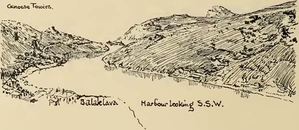
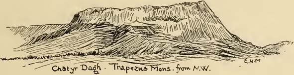
CHAPTER II. SEAS AND COASTLINE.
Before we even approach the coast of Scythia and discuss the knowledge of it possessed by the ancients, something must be said of their ideas concerning the Euxine Sea and its subordinate the Palus Maeotis[23].
Herodotus[24], for instance, takes the former to be 11,100 stades in greatest length, measured from the mouth of the Thracian Bosporus to that of the Phasis, and in greatest breadth 3300 stades reckoned from Themiscyra at the mouth of the Thermodon to Sindica. Moreover he thought that the neck between the Halys and Cilicia was only five days’ journey “for a well girt man3.” That means that he imagined the Euxine as stretching too far to the south at the eastern end : naturally, for this part, protected by the Caucasus, has a much warmer climate than the western4. As a matter of fact the broadest part is from the mouth of the Dnepr to Heraclea in Bithynia, but Herodotus was evidently ignorant of the great bay along the south side of his square Scythia, whereas we may put the Rugged Chersonese and Sindica opposite to it some way up the eastern coast of the same. In the figure he gives for the greatest breadth Herodotus is not very far out, it being (but in the western half) 325 geographical miles or 3250 stades; but between the points he mentions it is only 235 geographical miles or 2350 stades.
His error with regard to the length is more serious. The extreme e. and w. points are Batum and the bay south of Mesembria, but he neglects the westerly bight of Thrace and makes a straight line from the Thracian Bosporus to the Phasis 11,100 stades, about double the real distance. We may take it that in reckoning 70,000 fathoms for a ship’s journey in a day and 60,000 for a night he was taking the utmost possible, wherein he made no allowance for contrary winds and other obstacles. The cross measurement is more correct, as a ship could often take a straight passage north to south.
She would not go for long out of sight of land, for a little to the west at the narrowest part of the sea the highlands of the Crimea (Criu Metopon) and Cape Carambis may be seen at the same time.This exaggerated idea of the size of the Pontus present to the mind of Herodotus must have reacted on his view of Scythia and induced him to lay it out on too large a scale, another reason for our not extending it very far into the interior. In later times after the publication of Peripli and the advance of geography the ancients had a very good practical knowledge of the shape of the Euxine, comparing it justly to the asymmetrical Scythian bow[25].
They naturally exaggerated its size, but their methods of calculation always produced this effect: yet they paid much attention to the subject. Pliny[26] gives five different reckonings of the circumference of the Pontus, they vary between 2000 and 2425 m.p. ( = 16,000 to 19,400 stades), the real amount is about 1914 geographical miles ( — 2392 m.p. or 19,136 stades). He also quotes Polybius for the distance of 500 m.p. across from one Bosporus to the other, which is approximately correct.
One curious error persisted. Eratosthenes and Strabo[27] both regarded Dioscurias (Sukhum Kale) as the extreme point of the whole sea, lying in a corner (μυχο'ς) 6oo stades east of the mouth of the Phasis, which some old poet, Herodotus and Ptolemy make the extreme point. This should really be at Batum, which is still further south. The error seems to rest on a commercial superiority of Dioscurias which lasted during Hellenistic and early Roman times. It was the last point of the navigation of the right side of the Pontus : the mountainous coast between it and the Cimmerian Bosporus being dangerous and unprofitable.
For all their familiarity with it the Greeks never forgot that the Euxine’s first name was Axenos and most of them regarded a journey across it with some trepidation.
To this day it is not a favourite sea with sailors, who dislike its fogs, its sudden storms and the scarcity of good harbours along the greater part of its coast. These causes tended to isolate the Greeks of its northern shore ; in spite of the close commercial connection with the homeland no one voyaged to Olbia or Panticapaeum except on business, and Herodotus and the exile Dio Chrysostom are the only extant ancient authors of whom we can say that they visited the north side of the Euxine.Maeotis.
Wrong as was' Herodotus with regard to the Euxine, his ideas of the Palus Maeotis were even more erroneous4. He thought of it as not much smaller than the Pontus, whereas its real area is about one twelfth. He knew that it was nearly twenty days’ journey to the Tanais, elsewhere he gives 4000 stades from the Bosporus, and this he seems to have imagined as its width rather than the longest line that could be drawn in a narrow triangle. Already Scylax was a little less wild and thought of it as half the size of the Euxine5. The distance across to the Tanais was usually put at 2200 stades6, not so very much more than the actual distance of 1700: but most authors continue to give its circumference as 9000 stades7, a very strange exaggeration. Right on into mediaeval times
0 Strabo, vir. iv. 5, Agathemerus, 18.
7 Pliny, NH. iv. 78; Strabo, l.c.; Agathemerus, 10; Schol. in Dion. Perieg. GGM. 11. p. 457 ; Peripl. Anon., 118 (92), etc.
M.
the mouths of the Tanais were supposed to be exactly on the same meridian as the Bosporus, though Hippocrates speaks of the lake as stretching towards the summer rising of the sun. The ancients consistently regarded it as a lake or marsh and as the greatest lake they knew : hence perhaps their exaggerated idea of its size. Some even went so far as to regard the Cimmerian Bosporus as the true mouth of the Tanais[28]. On the other hand, some authors could not disabuse themselves of the notion that the Maeotis was connected with the Northern Ocean or at any rate with the Caspian[29].
Caspian.
With regard to the Caspian Herodotus and Ptolemy agree in making it an inland sea, though the former shews a tendency to make it balance the “Red” sea or Indian ocean[30]. But Strabo[31] [32], Mela8, Pliny6, and Plutarch7, all going back to Eratosthenes and perhaps to the Ionian geographers8, make it connected with the northern ocean. Considering how little they knew about it, it is remarkable that both Herodotus and Strabo had a very fair idea of its size. The latter’s information came from Patrocles, who was sent exploring by Seleucus. The idea of a passage from the northern ocean was due to the Greek belief in the symmetry of the world9, and the existence of an arm of the sea running not so much north as east. Of this Patrocles seems to have been aware, but no one ever got near the Volga mouth, which indeed with its seventy channels is singularly unlike a sea strait. Herodotus seems to have thought of the Caspian as having its greatest length from north to south, but later authors put it from east to west10. Survey of Coastline. The ancients never had a settled idea of the shape of the Scythian coast. The inaccuracy of the outline given by Ptolemy is a measure of the difficulty they found in getting their bearings. The requirements of their navigation demanded no more than a rough knowledge of the distances separating the cities, harbours and chief headlands as measured across the openings of unimportant or unnavigable inlets. Such knowledge they possessed in a very fair degree. The accuracy of the figures given by Ps.-Arrian and the anonymous compiler of the Periplus Ponti Euxini is remarkable when we consider the chances of corruption arising from the Greek methods of writing numbers. Of the inside of the country the Greeks knew hardly anything. They knew the appearance of the steppe and that great rivers made their way through it to disembogue in broad 6 NH. 8 Berger, op. cit., p. 57. 9 v. J. L. Myres, Geogr. Journal, vm. (1896) p. 605, On the maps used by Herodotus. 10 For the Araxes question and the rivers running into the Caspian v. infra, p. 30. n] Survey of Coastline. Mouths of Danube 11 shallow estuaries, but of the*, real direction of these streams’ flow they had no notion. They imagined a symmetrical scheme of rivers coming down at right angles to the coast. The supposed flatness of the steppe would of course offer no obstacle to channels running from one stream to another, a hypothesis representing trade routes connecting the lower course of one river with the upper part of another. Such portages have always been in S. Russia. The granite ridge that runs from Podolia to Taganrog causes the well-known rapids of the Dnepr and bends that stream into such an elbow that its upper waters are more conveniently approached either from one of the lesser rivers that fall into the Maeotis, or from the Ingul or Ingulcts. Hence the confusion between Hypanis and Borysthenes, the difficulties with the Panticapes and Gerrhus. But it is better to discuss the position of rivers with that of the tribes so intimately bound up with them in the description given by Herodotus. Till the time of Ptolemy we have no details of the Hinterland save the schematic picture of the river system and the names of innumerable tribes, whether assigned to localities or indeterminate. Herodotus just mentions the point Exampaeus and the city of the Geloni, but these would be fixed by the river and tribe scheme, if any determination of their place could be reached. Before adventuring ourselves in the boundless interior let us see how much the ancients knew of the coast between the mouths of the Danube and the steep slopes of the Caucasus where they overhang the sea!. Different accounts of the Danube mouths2 are given by different authors3, and none of them agree with the present state of things, but a comparison between the actual lie of the country and the various descriptions of its ancient condition renders it possible to account for the apparent contradictions of our authors and to trace the history of geologic change since the time of Herodotus. The delta begins between Isakcha and Tulcha, where the Kilia and St George arms separate, and forms a triangle with two sides of 46 miles and a base of 33 miles long, to which is added a four-sided piece enclosed by lake Rasim, the Dunavets, the sea, and the St George arm. All this space is marsh, subject to floods except for five sandbanks upon which poor villages are built. This tract cannot correspond to the ancient delta, which included the island Đĺéńĺ whereon the Triballi with their wives and children took refuge from Alexander when he drove them from their country[33]. For the banks of this island were steep and the current, confined by the high banks, swift. Alexander only prevailed by crossing the main stream and discomfiting the Getae on the left bank. 1 For the sake of convenience in handling, I have reproduced the central part only of Latyshev’s combination of Ptolemy’s maps of European and Asiatic Sarmatia, Dacia and the Caucasus. With the outlying parts from the Baltic shore to the NW. round by W. and S. to Transcaucasia on the SE. we are not concerned. To the N. are very few names which represent living information, but mostly they are the Herodotean tribes which obviously could not be accommodated in the comparatively well-known central regions. I here give some interesting points to the N. and E. as placed by Lat.; Ptol. does not locate tribes exactly. Borusci long. 63°, lat. 58° ; Rhipaei Montes 63°, 57° 30'; Alexandri Arae 63°, 57°; Nasci 63°, 57°; Fontes Tanaidis 64°, 58°; Modocae 67°, 60° 30'; Zacatae 67°, 59° 30'; Caesaris Arae 68°, 56° 30'; Asaei 68° 50', 59° 40'; Perierbidi 68° 30', 58° 50'; Fontes Rha Occidentales et Finis Montium Hyperboreorum 70°, 61°; Svardeni 71° 30', 59° 30'; Chaenides 74°, 59°; Epistrophe Rha 74°, 56°; Confluentes Rha 79°, 58° 30'; Zinchi 74°, 48° 30'; Montes Hippici 74°, 54°—81°, 52°; Finis M. Coracis 75°, 48°; Caucasus M. 75°, 47°—85°, 48°; Alexandri Columnae 77°, 51° 30': Fontes Vardanis 78°, 48° 30'; Portae Sarmaticae 78°, 47° 30'; Alterae P. Sarm. 81°, 48° 30'; Sacani 82°, 51°; Ceraunii M. 82°, 49° 30'—84° 52'; Epistrophe Rha 85°, 54°; Ostium Rha 87° 30', 48° 40'; Fontes Rha Orientales 90', 61°. 2Braun, Investigations, pp. 182 sqq. 3 Herodotus iv. 47, Ps.-Arrian Peripl. 35 (24 H.), Ephorus ap. Strab. Vii. iii. 15, Dionysius Perieg. 1. 301, and Anon 93 (67) give five mouths ; Pliny, NH. iv. 79, Ptolemy ill. x. 2, who has a completely wrong idea of the Delta’s shape, six; Strabo vii. iii. 15, Pomponius Mela II. 8, seven. Nowadays we have but three ; Kilia Mouth, Sulina Mouth, and St George’s Mouth. Đĺéńĺ then was an island with high banks : and therefore outside the present delta. Still most of our authorities say that it was between two arms of the river and the sea. Some[34] put it between the St George mouth (Ostium Peuces, 'lepov στόμα) and the next to the N. (Naracu stoma, Ναράκι-ον στόμα), on what is now called St George’s Island: and Dionysius has much the same idea (1. 301). But Strabo (vn. iii. 15) says merely that it lies near the mouths and that there are other islands above and below it, i.e. it is not directly on the sea, but even 120 stades=i5 miles up stream. We have no data for exactly determining the amount the delta has grown in the last 2000 years, except that according to the Peutinger Table Noviodunum (Isakcha) is 65 Roman miles = 520 stades from the Sacred mouth along the course of the river; Ptolemy makes it about 477 stades or 60 miles in a direct line. This brings us to just about a line of sandbanks reaching from Vilkov by Ivancha to Teretsa, and representing an old coastline which we may take as the coastline at the beginning of our era. This line gives about the right amount, 47 versts (31 miles = 279 stades), which we get as the distance between the old mouths from N. to s. in Arrian (280 stades) and Strabo (300 stades). If now we measure our 15 miles up stream from our ancient Sacred mouth we come upon rising ground which takes up the rest of the Dobrudzha up to Tulcha. Braun supposes that formerly an actual branch of the Danube cut off this triangle from the main land and fell into the sea somewhere opposite the channel Portitsa, within twelve miles or so of I Stropolis (? Karanasup), having sent off an arm into a marsh, now represented by lake Babadagh, and having formed lake Rasim. Bruun[35] anticipates Braun and says there exist traces of such a channel. This state of things is represented by Pliny’s confused account[36]. When this branch got silted up confusion arose in the mind of Ptolemy, who found the southernmost mouth given variously as the Đĺéńĺ mouth and the Sacred mouth, and he identified them and so was brought to seek the island Đĺéńĺ in the modern delta and to throw out all the measurements and distort the shape of the whole delta to try and reconcile different accounts both founded on fact but referring to different times. Without detailed investigation of the actual lie of the land between the main course of the Danube and Babadagh it is impossible to say whether Dr Braun has really disentangled the labyrinth of the Danube mouths. If it is at all possible, such a solution would best fit the case. 3 Chernoniorje, I. pp. 48—59. 4 1. c. Primum ostium Peuces, mox ipsa Peuce insula in qua proximus alveus [nomen deest] appellatus xix m. p. magna palude sorbetur: ex eodem alveo et supra Histropolin lacus gignitur Ixiii m. p. ambitu, Halmyrin vocant. It is just conceivable that within historic time Pence never was a real island or Portitsa a real mouth of the Danube, but that the first was defensible across a short isthmus and along the course of a minor stream flowing into Babadagh lake, and so gained the name of island, to be a refuge for the Triballi and later (when it almost certainly was no longer separate) for the division of the Bastarnae hence called Peucini. So there may have been a false mouth to the south of the delta as there was to the N. or ships may once have gone in by Portitsa and across lake Rasim to ascend the stream now represented by the Dunavets. We can see by the varying accounts of authors that the real mouths of the river closed and shifted, as has happened with all the Black Sea rivers, but that old names and old descriptions lived on in Geography books and led compilers astray. Only Strabo who prided himself on direct up-to-date information and avoided padding copied from other books, gives an intelligible account of the district as it was in his time. The question of the number of mouths is never settled, to-day one may count anything from three to tAvelve and no doubt it Avas the same in ancient times. We may take it then that while it is hopeless to identify the lesser mouths (we have ten different names preserved in various authors) Peuces ostium was originally what is now Portitsa, Ostium Sacrum (later also called Peuce) corresponded to St George’s mouth, Naracu stoma tvas half-way between that and Calon stoma, the Sulina mouth (lately canalised and made really navigable) ; that Pseudostoma, Boreon stoma, Spireon stoma corresponded to branches of the Kilia mouth, and Psilon stoma was a still more northerly channel running out through the marshes (Thiagola) at Zhebriany. The stretch from the Ister to the Tyras is not important. Strabo tells us of two lakes, one open and one shut, corresponding to Sasyk and probably Alibey, two limans now communicating with the sea by narrow channels. Between them came the place τα ’Ανπφίλου of Peripl. Anon, and next his Cremnisci, which Pliny also gives Avith Aepolium and Montes Macro- cremni, which seems a very grand name for the low cliffs of this coast. Near the corner of the Dnestr Liman we have Hermonactis vicus (Strabo and Ptol.) and Turris Neoptolemi (Strabo and Anon.). Of this latter there seem some traces left in the foundations of a tOAver. It is ascribed to Neoptolemus the Admiral of Mithridates, and appears to have been a lighthouse1. A difficulty is in the distance given by our authorities for the space between Danube mouth and Dnestr mouth. Strabo and Anon, make it 900 stades. Really it comes to about 600. Ps.-Arrian obviously left the coast at Portus Isiacorum (Odessa) and cut straight across to the Danube mouth, making it 1 200 stades, probably by adding on half the distance for possible curves of the coast. He says that there were no settlements in that space έρημα καί ανώνυμα, whereby he did an injustice to Tyras, which was still coining in Arrian’s time2. Anon, filled in the gap with names gleaned we 1 Becker, Trans. Odessa Sec. III. p. 151, On 2 An argument for its not being the real Arrian, the coast of the Euxine between the Ister and the v. p. 24, n. 3. Borysthenes with reference to ancient settlements. know not whence, and made the total distance agree with Ps.-Arrian. But why Strabo should be 300 stades out it is hard to say, unless he applied a measurement stretching to the southern and most used Danube mouth to the northern nearest one. Pliny gives 130 m.p., that is 1040 stades, from Tyras to Pseudostoma. The ancients all seem to have overestimated this unattractive piece of coast. Ptolemy on the other hand makes too little of this very distance. From Thiagola (Zhebriany) to the Dnestr mouth he gives what represents 390 stades, while further to the e., e.g. between Dnestr and Dnepr, he is substantially correct. Dr Braun has well shewn that just here comes the break in his bearings, due to his having Byzantium two degrees too far to the n., in the same latitude as Marseilles. Harpis, the other point he gives, is still orientated from the s., and represents Eskypolos, the town at the end of the Roman wall that guarded the lower Danube. Strabo says that 140 stades up the river Tyras are the towns of Niconia on the right and Ophiussa on the left. Pliny says that the town Tyras was formerly called Ophiussa. We need have no doubt that it is the present Akkerman, mediaeval Moncastro or Belgorod. What we know of its history and coinage will be found further on (ch. xiv.). Niconia would be Otarik, where some antiquities have been found. Strabo adds another datum, 120 stades, for the distance between Tyras town and the mouth of the river, more close than the figure he has first given and agreeing with Anon., who says that rd NeoTrroXe/zou was 120 stades from Tyras river, surely a mistake for Tyras town[37]. The position of the island Leuce, now Phidonisi, is accurately defined by Strabo, who says it lies 500 stades from the mouth of the Tyras, and Demetrius (ap. Anon. 91 (65)), who gives 400 stades as its distance from the mainland at the Danube mouth. This is fairly correct. Other authors confuse it with the Apo/ws ’AytXXeco?, or the nameless island near the mouth of the Borysthenes, now called Berezan. First mentioned by Arctinus, Leuce is spoken of by Stesichorus in his Palinode, by Pindar {Nem. iv. 49), Euripides {Androm. 1259), Lycophron {Alexandra 186), and gradually the romantic legend grew that we find in its fullest form in Philostratus Junior[38]. To the e. of the Tyras the next place mentioned is Physce in Ptolemy, probably at the mouth of the Baraboi, and Ps.-Arrian’s Portus Isiacorum, interesting as being the forerunner of modern Odessa, and 50 stades (Anon. 87 (61)) further on Istrianorum Portus, probably by the mouth of the Kujalnik or Hadzhi Bey limans, once estuaries navigable from the sea. The cliffs gradually rise along this coast, and the name Scopuli (Anon. 87 (61)) may be justified. The next point is Ordessus (Ptol.) or Odessus (Ps.-Arr. and Anon.), probably at the mouth of the Axiaces or Asiaces (Mela), now the Tiligul, cut right off by a bar, but once open. Here, near Koblevka, Uvarov found traces of ancient habitation[39]. and a discussion of the whole question and of the worship there paid to Achilles by the Olbiopolites, in Latyshev, Olbia, pp. 55—61 and inf. chap. XV. 3 C1 A. S. Ouvarov, Recherches surlesAntiquites de la Russie MMdionale, Pl. xxvi. and xxvn. Opposite the liman Berezan is the island of the same name referred to by Strabo and Ps.-Arrian. This island was early settled by the Greeks, as upon it have been found vases of Milesian type and archaic asses of Olbia[40]. It is constantly confused with Leuce. From here it is just 60 stades (Anon.) on to the mouth of the great liman in which the Bugh and Dnepr join. Altogether the distances along this coast are very much what Ps.-Arrian and Anon, make them. The common estuary of the Bugh and Dnepr is one of the finest in Europe, its very size prevented casual observers understanding how the land lies. Dio Chrysostom {Or. xxxvi.) gives us the best description. Herodotus and Dio alone grasped the fact that the city which its citizens called Olbia, and strangers Borysthenes, lay upon the Hypanis, the Bugh, not upon the Borysthenes river, the Dnepr. The confusion was natural, but the site of Olbia could never have been determined from the texts. The. mounds, coins and inscriptions dug up at Sto Mohil (the hundred Barrows), a mile to the south of the village of Iljinskoe or Parutino, have settled the matter. Alector mentioned by Dio must be Ochakov opposite the long spit of Kinburn, well known in the Crimean war. Between them is a bar with a very narrow channel under the guns of the fort. When you have passed the fort the great liman is spread before you and even at Olbia the opposite side of the Bugh is so far distant that the impression produced is that of a lake rather than a river. Hence the variations of distance given by the authorities, Scymnus and Anon, making it 240 stades up from the mouth of the river, Strabo (who says Borysthenes) and Dio 200 stades. Pliny with his 15 m.p. must have measured from the point where a ship leaves the Dnepr channel and begins to ascend the Bugh. On the Borysthenes itself there seems to have been no important settlement. On its left bank and on the islands of the river still survived into last century remains of the woods which gained the district the name of Hylaea, of which Herodotus, and after him Mela and Pliny, speak. It hardly required many trees to attract attention in the bare steppe land. We need not suppose that Valerius Flaccus meant anything when he wrote {^Ir^. vi. 76) : Densior baud usquam nec celsior extulit ulla Silva trabes: fessaeque prius rediere sagittae Arboris ad summum quam pervenere cacumen. He had read in his Mela: Silvae deinde sunt quas maximas hae terrae ferunt[41]. The position of the Hylaea is a favourite subject for discussion, but the difficulty only arises if we put the Panticapes[42] (which flows into the Hylaea) to the west of the Borysthenes and identify it with the Ingulets, so as to give room for the Georgi between it and the Dnepr. But if river valleys, but is inclined to make too much of it, and W. W. Dokoutchaiev, Les Steppes russes autrefois et aujourd’hui, Congr'es International d'Archäologie prehistorique et d’Anthropologie, //'. Session h Moscou, Vol. I. 1892. 3 Her. iv. 54. Vide infra, p. 29. we suppose that it was the Konka across the Dnepr valley it would flow precisely into the wooded region to the south of the estuary[43]. Ptolemy puts Olbia on the Borysthenes. In face of such a mistake it seems risky to assign positions to the other cities he mentions. But near Great Znamenka and Little Znamenka overlooking the well-watered flats of the so-called “great meadow” we find the remains of fortified settlements with Greek pottery[44], which may mark his Amadoca and Azagarion. At the mouth of the Dnepr liman we have Kinburn spit, which is probably the site of Ptolemy’s *ΑλAnon. 1200, Agrippa 80 m. p. =640 stades. The 60 stades given as the distance from the shore is not far out. So with the gulf called Carcinites or Tamyrace the 300 stades is not far out for the distance across the mouth, but the ancients had the most exaggerated idea of its extent to the eastward. Strabo puts this at 1000 stades and says some multiplied this amount by three. On the other hand, Pliny and Strabo both give the breadth of the Isthmus of Perekop, Taphrae, at 40 stades (5 miles) which is very near. Strabo adds that others reckoned it at 360 stades, which is about the distance from the gulf of Perekop on the w. to Genichesk on the sea of Azov6. Again they give a very good description of the Putrid Sea (Sivash), but make it very much too big. This is one of the most unmistakeable c. ix., cf. Latyshev, ‘ Island of S. Aeth.’ in Journ. Min. Pub. Instr. St P., May 1899, p. 73]. 4 losPE. iv. 63. V. ch. xv. 5 losPE. 1. 179—183. c This is probably the site of Asander’s wall, v. ch. XIX., no doubt on the site of a former ditch that gave its name to the place. features of the whole coast line and naturally impressed those who came near1. At this point Pliny'-’ gets hopelessly confused, fie mixes up the Putrid Sea, the liman of the Utljiik or Moldchnaja and the Hypanis (Bugh) with one of the limans about the Peninsula of Taman at the opposite corner of the Sea of Azov and the Hypanis (Kuban), and one can make no sense out of his jumble of names. Lacus Buccs...Coi'ctus Maeotis lacus sinus...aumes Buses, Gerrhus... hardly tally with regio Scythia Siudica nouiiuatur. One cannot help thinking that as now, so formerly, the same geographical names were repeated along this coast. Every other salt lake is called Sasyk, the cutting through a spit of sand is called Bugas, there are two Kujalnik rivers, an Ingul and an Ingulets (a diminutive though it is the bigger river), a Don and Donats, two sandspits called Dzharylgach, two places called Ak Mechet, two Sivash lakes, two rivers Salgir, and two Karasu, so in old days there were two rivers Hypanis, Bugh and Kuban, perhaps two Gerrhus, more than one Panticapes and several Eiones, Insulae Achillis and so forth. Just as the Russians have adopted Tartar words as names, so the Greeks took native words meaning river or salt lake or channel. Hence the confusion produced by the attempts of Ptolemy or Pliny to distinguish these names without local knowledge. In the Gulf of Carcinites Pliny3 mentions the islands Cephalonnesus, Spodusa and Macra, and Ptolemy gives position to the first of these. Mela, Pliny and Ptolemy also mention a town, Carcine, which is merely the Carci- nitis of Herodotus (iv. 99) and Hecataeus (fr. 153). Herodotus says that the Hypacyris here falls into the sea and Mela (11. 4) copies him inaccurately, sinus Carciuites, in eo urbs Carciue, quaui duo fiumiiia Gerrhos et Ypacares uuo ostio efflueutia adtingunt. Pliny is still further removed and speaks of the Pacyris (sic)4. The only stream that runs into the gulf is the Kalanchak, now quite unimportant, but from its mouth hollows and what were once water-courses may be traced far inland almost to the Dnepr about the land called Gerrhus. This may have been a way of getting quickly up to that district, but it must have been early abandoned owing to the failure in water of which we can trace the effect all over the steppe region. The position of Carcinitis town has been a great bone of contention because it has been assumed that it must have been situated on the gulf Carcinitcs, whereas the town Cercinitis is plainly put in the western Crimea by Ps.-Arrian and Anon, (who adds a name Coronitis). Across the gulf 300 stades from Tamyrace we find mentioned Calos Limen, 700 stades further on Cercinitis, and 600 stades beyond Chersonese. Reckoning back exactly from the well-known site of the latter we get Cercinitis at the mouth of the closed estuary Donguslav, the position approved by Bruun and Burachkov. Another 700 stades brings us too far round the corner to give the required 300 more to Tamyrace. If we take all the distances to be as usual somewhat exaggerated we may put Cercinitis just to the west of the modern Eupatoria on a spot where there are traces of a Greek town (v. Chapter xvi.)5. Coins occur marked KEPKI and KAPK, similar in 1 Strabo vii. iv. 1. 4 NH. iv. 84. 2 NH. iv. 84. 5 Excavations of N. Ph. Komanchenko, TRAS. 3 NH. iv. 93. viii. pp. 219—236. M. 3 type to the coins of Chersonese (Pl. iv. i, 2, 3, cf. iv. 17), and even an inscription1 has been found ; and we can put Calos Limen at Ak Mechet or at the next little bay along the coast. So Cercinitis is another example of the curiously inaccurate naming of places along this coast by which the town Borysthenes (Olbia) was not upon the Borysthenes and Istrus not actually upon the Ister. The gulf Carcinites was the gulf just beyond Carcinitis, up which the men of that town traded by way of the Hypacyris until the latter dried up, and so it was thought of as standing at the mouth of that river. Later Ptolemy calls Carcinites itself a river. If this was the view of Herodotus we can see why he had no idea how much the Crimea is divided from the mainland, and a river being provided we need not trouble about Donguslav lake. At Chersonese we again reach a definite point. A discussion of the topography of the district lying immediately about it will best go with the sketch of its history and remains that will be given in Chapter xvn. Strabo (vn. iv. 2) gives 4400 stades as the distance we have come from the Tyras. But with moderate allowance for the curves of the coast the distance can hardly come to more than 3000 stades. Strabo must have reckoned in the circumference of the Carcinites gulf and made his ship go right up to Olbia and other places of call on the way. Anonymus (83 (57)—87 (61)) adds up to 3810 but gives 4110 (89 (63)), having missed 300 stades somewhere about Tamyrace. He says that Artemidorus gives 4220, but that is going round Carcinites gulf. Beyond Chersonese Strabo (l.c.) rightly mentions the three deep bays and the headland now C. Chersonese. C. Fiolente is much more picturesque, but not so important geographically as C. Chersonese, and is not likely to be meant by Strabo. Portus Symbolon is clearly Balaklava, and by it was Palacion or Placia, built by the natives as a menace to the whole Fig. i. Minor Peninsula. The fancy that this narrow inlet is the harbour of the Laestrygones has nothing for it but the names of Dubois de Montpereux, after Pallas the first scientific explorer of these parts, and K. E. von Baer2 who was rather a scientist than a historian. 1 BCA. x. 20. 2 Ueber die homerische Localitäten in der Odyssee, Brunswick, 1878, v. inf. Ch. xin. The southernmost cape of the Crimea was called by the ancients Criu Metopon and was very well known. It was supposed to be just opposite to Carambis on the coast of Asia Minor and they could both be seen from a ship in mid sea. The high land behind the capes can really be seen. This comparatively narrow part was reckoned to divide the Euxine into two basins, but it is hard to settle what particular headland was the actual Ram’s Head. Pliny1 gives it as 165 m.p., i.e. i32ostades from Chersonese town, which would bring it to Theodosia; and 125 m.p. = 1000 stades on to Theodosia, which would bring it back to C. Sarych. Anon. (81 (53)) makes it 300 stades from Symbolon Portus. That would be about Aju Dagh. But he also makes it 220 stades from Lampas (Lambat), which would bring it again to near Aj Todor, not in itself a very prominent cape, chiefly interesting for a Roman station of which M. I. Rostovtsev has given an account2. But above it Aj Petri rises high and can be seen further than Aju Dagh, and the latter is considerably to the north, so that perhaps it is best to call Aj Todor Criu Metopon. The most southerly point is actually Kikeneis or Sarych, still further to the west. ' The position given by Ptolemy also leans in favour of Aj Todor. Ptolemy’s Charax—Pliny3 mentions Characeni—may well have been the settlement on Aj Todor. In the interior Strabo mentions Mount Trapezus, Chatyr Dagh (vn. iv. 3), and it is at least as much like a table as a tent. Fig. 2. The modern, place-name Partenit near Aju Dagh suggests that here may have been a sanctuary of the virgin goddess to whom all the Tauric mountains were holy. Lampat, the next village, has also preserved its Greek name mentioned by Ps.-Arrian (30 (19 H.)) and Anon., and Alushta is the ’Αλουστοι of Procopius4. Beyond Lampas 600 stades further east we have what Ps.-Arrian calls λιμ,ήρ ^κυθοτανρων έρημος, 200 stades short of Theodosia. Anon. (78 (52)) calls it also 'Αθηναίων. These 200 stades bring us to Otiiz, the most probable site, for 600 stades from Lampas makes the site too close to Theodosia. The name of Sugdaea, Sudak, so important in mediaeval times, does not occur before Procopius (1. c.). Theodosia is again a certain site, and has recovered its old name (v. Ch. xviii.). From near Theodosia an earthwork goes across to the beginning of the Arabat Spit on the Maeotis. This seems to represent the boundary of 1 Nil. iv. 86. 3 yv//. iv. 85. 2 Journ. Min Pub. Instr. St P., May 1900, 4 De Aed. ill. 7. v. inf. Ch. xvii. the kingdom of Leucon as against the Scyths and Tauri of the peninsula rather than the Wall of Asander[48]. At 280 stades from Theodosia Ps.-Arrian (30 (19 H.)) and Anon. (77 (51)) give Cazeca, clearly Kachik the eastern headland of the bay of Theodosia, about 30 miles from that city following the coast round; 180 stades further east, according to Anon., was Cimmericum, evidently Opuk, where Dubrux[49] discovered traces of a fortified town with a harbour. This is rendered quite certain by the existence opposite here of two skerries mentioned by Anon. (76 (50)). From the head of Lake Uzunlar, once an arm of the sea, goes another embankment to Hadzhibey on the Sea of Azov. At a distance of 60 stades Anon, gives Cytae, also mentioned by Pliny[50] and called Cytaea by Scylax (68). The 60 stades would bring it to Kaz Alii. Aera[51] or Acrae (Pliny) would come at Takil Burun, 30 stades from Cytae on the headland marking the entrance of the Cimmerian Bosporus. The site of Hermisium5 is uncertain. After another 65 stades we reach Nymphaeum, undoubtedly Eltegen, where there are evident remains of a city and harbour (v. Chapter xviii.). Tyritace6 seems to have been at the head of Churubash Lake, once an arm of the sea. Dia of Pliny is uncertain, but must have been between Tyritace and Panticapaeum. This latter was more than the 85 stades from Nymphaeum by Tyritace, given by Anon., but there seems no reason to question these identifications. As to Panticapaeum, there can be no doubt that its Acropolis was the hill now called Mount Mithridates (v. Chapter xix.). The identification of the several small settlements about the Cimmerian Bosporus, and on the Peninsula of Taman, is rendered difficult by the uncertainty as to changes in the one case in the position of sandbanks and spits which would necessarily modify the distances reckoned from one place to another, in the other to still more considerable changes in the water-courses which intersect the peninsula, deriving from the Hypanis or Kuban, and subject not only to ordinary silting up, but to the more unusual action of the mud volcanoes that abound in the district. Next to Panticapaeum, on the west side of the strait, we have Myr- mecium, mentioned by most of the authorities as being 25 (Anon.) or 207 stades away. This would fairly bring us to the place called the Old Quarantine, just the other side of the bay. Somewhere near must have been the town which early issued coins marked APOA and An (Pl. ix. 10), and which seems to have been absorbed in Panticapaeum, unless Apollonia was indeed the Greek name for that city. Forty stades further on (Strabo) we have Parthenium, while Anon, makes it 60 from Myrmecium to Porthmium. Probably these both represent the site of Jenikale lighthouse at the narrowest point of the channel, whose breadth is regularly given as 20 stades, which is about right. It is really about 90 stades from Panticapaeum. Ps.-Arrian and Anon, reckon the strait to be the mouth of the Tanais, and this is not unreasonable according to the view that makes the Maeotis a mere marsh and no sea. 5 Pliny, NH. iv. 87, Mela n. 3. 6 Steph. Byz. s.v.; Ptol. TvpiKraK TvpiaraKrj. ~ Strabo vii. iv. 5. t) ; Anon. 76 (50) On the west of the Maeotis, between the Bosporus and the Don, except for Herodotus and his Crcmni (iv. 20, 110, perhaps near Genichesk), Ptolemy is the only authority, and the names he gives are mere names not to be identified, for he has a wrong idea of the lie of the land, and in any case there seems to have been no important settlement on this coast. Only at the headland Zjuk, about 40 miles to the west of the entrance to the straits, we have remains of a Greek village[52], which may have been Hcracleuni or Zenonis Chersonesus. So too no purpose can be served by endeavouring to identify the rivers of this coast. The mouth of the Don is a more interesting point. Of Tanais town and its inscriptions we will treat later (Ch. xix.). Its site in the second and third centuries a.d. was clearly near Nedvigovka on the Dead Donets, but it is quite probable that the original Tanais town destroyed by Polemo was on the site of Azov, or in the delta at Elizavetovskaja Stanitsa[53]. We cannot identify the island Alopecia, mentioned by Strabo (xi. ii. 3), Pliny[54] and Ptolemy. It has probably been joined to the delta, which is growing very fast. In any case it is hard to see how it can have been 100 stades below the town. The east coast is more important because of its fisheries, which supplied much of the rapt^o? exported from the Pontus[55]. The first, 800 stades from the Tanais, was at the Great Rhombitcs, probably the Jeja. At Jeisk, at its mouth, is still a great fishery. After another 800 stades came the Little Rhombites by Jascnskaja Kosa, where there once flowed into the sea the Chelbasi and Beisug rivers which now reach it only during the spring floods ; 600 stades more past the northern delta of the Kuban brings us to Tyrambe, possibly Temrjuk or Temrjuk Settlement, between which an important branch of that river (the Anticites or Hypanis) reaches the Maeotis. At a distance of 120 stades was Cimmerice or Cimmeris village, probably the nw. point of the island Fontan. This was the point from which vessels reckoned their course across the Maeotis. 20 stades beyond was Achillis vicus, at the narrowest point of the strait, opposite Parthenium. These figures all seem put too low by Strabo (xi. ii. 4—6). Perhaps'the current that flows down the Sea of Azov helped the vessels along and led the navigators to underestimate the distance. The natural course would be for ships to go right straight across to Tanais and come down the east coast to take in their cargoes of fish. Ptolemy mentions these same points as Strabo, but his authority is not to be preferred. The topography of the Taman Peninsula is, as we have said, particularly difficult. The interweaving of land and water made it hard for Strabo (xi. ii. 6—10) to describe, and the changes since his time, both in his text and in the land surface, make it still harder to apply his description[56]. In general the very greatest caution should be used in explaining difficulties of ancient topography by geological changes, but here three powerful 1870, and History of Archaeological Investigations in the Taman Peninsula, M. 1876, both repr. St P. 1898 ; but cf. I. E. Zabelin, Trans. Third Arch. Congr. (Kiev) 1874, II., Explanation of Strabo’s Topography of Bosp. Ciin. agencies have been at work. Something has been done by the mudvolcanoes found on both sides of the strait, but most active to the east of it. Their activity is not mentioned by the ancients, they may have been quiescent during classical times : since then there have been thrown up the cone of Kuku Oba, which is the most striking object of the Bosporus, and some of the cones just south of Sennaja, the site of Phanagoria. One of these it was that cast up, in 1818, a Greek inscription1, referring to the construction of a temple of Artemis Agrotera2. Another agency in changing the face of the land is the action of the Kuban. Whereas the northern branch, the Protoka, has formed an ordinary delta in what was once a bay of the Maeotis, the southern branch flowed into what must have been a group of islands and found its way to the sea through channels and sounds which itself it has done much towards silting up. Lastly the sea itself has encroached on the side towards the Bosporus. Here the shifting currents have alternately washed the shore away and deposited new sandbanks, there is even reason to suppose that the level of the land is sinking. Columns, the remains of a temple, are seen in the sea along the northerly spit opposite Jenikale, and again off the site of the ancient Phanagoria. Along the coast from Tuzla to C. Panagia barrows are seen in section upon the cliff. The latter cape takes its name from a church now swallowed up by the waves. At Taman itself the cliff, with remains of an ancient town, is being washed away. The statues from the monument of Comosarye3 were found in the sea, because the headland of SS. Boris and Gleb on which it was built had been encroached upon. In the district, then, there are three main bodies of water, the Gulf of Taman, Akdengis (or Akhtaniz) Liman, and Kizil Tash Liman. Branches of the Kuban flow into the two limans, but the Gulf of Taman is at present cut off from it. But there can be little doubt that a depression running east from the cove Shimardan by Lake. Janovskij to the Akdengis liman represents an old channel4. The only certain points in the whole peninsula are Phanagoria5, the great masses of debris and rows of barrows about Sennaja leave no doubt where we must seek the capital of the Asiatic half of the Bosporus kingdom, and Gorgippia, long supposed to be Anapa and recently proved to be so by inscriptions6. If we take the Gulf of Taman to be Strabo’s Lake of Corocondame, the village of that name must have stood at the base of the southern sandspit that partly cuts the gulf off from the Bosporus7. But Strabo says (xi. ii. 14) that Corocondame is the point from which begins the eastward sail to Portus Sindicus, and marks the beginning of the Bosporus strait, corresponding to Aera. If then we suppose that C. Tuzla extended a little further west and 1 App. 29 = losPE. 11. 344. 5 Suvorcyv’s Fort Phanagoria by Taman was 2 Goertz, Topography, p. 45. named according to the view current in his time, 3 App. yo—losPE. 11. 346. cf. Clarke’s Travels, 11. pp. 81—83. 4 v. Map in ABC.=KTll. p. 108, f. 141, after 0 losPE. iv. 434. BCA. xxin. 32. Dubois de Montpireux. 7 Anon. 64 (23). from it ran out a spit like the southern spit for a little over a mile (xi. ii. 9), we get about 80 stades across to Aera instead of 70 (§ 8), 130 stades bring us to Patraeus and the monument of Satyrus (Kuban’s Farm and perhaps Kuku Oba) ; 90 stades from there would be A chillis vicus, on the northern spit, where columns are seen in the sea, just opposite Jenikalft1. Cimmeris would be 20 stades further, at the base of the northern spit, just at the point where the navigation of the Maeotis begins. Only the distance to Tyrambe is much more than 120 stades, but this seems wrong in any case. The actual site of Corocondame seems to have been washed away. It has been usually placed at Taman, inasmuch as that was the site of a very ancient Greek settlement, and some have seen in Tmutarokan, the mediaeval Russian name of Taman, an echo of the ancient Corocondame, but Taman does not lie on the Bosporus itself. It is impossible to say that from it one sails eastward to Sindicus Portus, and it is much more than 10 stades from any possible entrance to the gulf. “ Above Corocondame,” says Strabo (xi. ii. 9), “ is a fair-sized lake ” (or liman), “which is called after it, Corocondamitis. It debouches into the sea 10 stades from the village. Into this lake flows a channel of the Anticites river, and makes an island surrounded by the lake, the Maeotis and the river....” § 10. “When one has sailed into Lake Corocondamitis one has Phanagoria, an important city, and Cepi, and Hermonassa, and the Apaturum, the temple of Aphrodite. Of which Phanagoria and Cepi are built on the said island on the left as one sails in, the rest of the cities are on the right beyond the Hypanis ” ( = Anticites), “in the land of the Sindi. In the land of the Sindi is also Gorgippia, the royal city of the Sindi, and Aborace.” § 14. “ From Corocondame you sail straight off to the east 180 stades to Portus Sindicus” (probably at the entrance to Lake Kizil Tash (170 stades)). “It is 400 stades further to what is called Bata, a harbour and village” (now Novorossijsk (500 stades)). From this it is clear that Phanagoria being at the bottom of the Gulf of Taman, the channel of the Kuban came just south of it, and somewhere on the same island was Cepi, usually put at Artjukhov’s farm. But there is no way of identifying Hermonassa, Apaturon, or Pliny’s Stratoclia, nor of giving names to the large number of sites of ancient settlements. The district was very thickly populated in antiquity and is covered with villages, forts, earthworks and barrows, from which latter some of the most beautiful objects have been recovered. Anon. (62 (21) sqq.) gives us more details of this part2. He gives the distance from Hieros Limen (another name for Bata or Patus) to what he calls Sindica or Sindicus Portus as 290 stades (it is rather more than 300 to Anapa), and says it is 540 on to Panticapaeum, which is about right. Next he speaks of Corocondame and its liman, which he says is also called Opissas: and the circumference he gives at 630 stades ; this is about right if we reckon in the shores of Lake Akdengis. It is hard not to wonder whether Opissas was not the name of this liman—“the 1 On the Euxine coast such spots were con- 2 Cf. Bruun, Chernotnorje, II. 242—270. nected with the name of Achilles. backwater.” He adds that Hermonassa is 440 stades from the entrance of the lake and 515 by it to the entrance of the Maeotis. It seems as if he measured by Lakes Corocondame and Akdengis and some passage of the Kuban into Lake Kizil Tash, so that Hermonassa would be one of the sites on the north shore of that liman. Of the Greek settlements in this peninsula Phanagoria (Ch. xix.) was a colony of Teios, Cepi of Miletus, and Stephanus Byzantius calls Hermonassa a settlement of lonians, repeating what Dionysius (1. 553) says of all these places, ev0a re vaerdovcriv ’IcoptSos eieyovoi. aLTjs. The coast east of Anapa hardly comes into our province. The ridge of the Caucasus leaves such a small distance between itself and the sea that there is no space for rivers or harbours or anything but a narrow tract of steep ground inhabited by tribes which have always been well known for savagery. The piratical row-boats that Strabo (xi. ii. 12) calls camarae were still in use in the last century, according to Taitbout de Marigny[57], and the coast always had a bad reputation until the Russians were forced almost to clear it of inhabitants. About 300 stades from Gorgippia (Anapa), the last city of the Bosporan kingdom, Strabo gives Bata, called by Scylax Patus, and later by Ps.-Arrian and Anon. Hieron, now Novorossijsk'-’; 180 stades further they give Pagrae, Gelendzhik. This whole coast is described in detail by Ps.-Arrian (26—28 (18 H.)), but it was never occupied by the Romans, who left the country between the Bosporus and Dioscurias untouched. Probably there was something of the nature of a sphere of influence. Arrian’s jurisdiction as legate of Cappadocia only extended as far as Dioscurias. He could not have interfered with the Bosporus, which was in relation with Lower Moesia. The periplus that bears his name has been unskilfully tacked on to the account of his real expedition : a reference to the death of King Cotys does not come in at all well. The addition seems to date from Byzantine times, and to have used sources open to Anon., who did not, however, copy Ps.-Arrian[58]. Strabo (xi. ii. 12 —16) gives all detail necessary for this coast. According to Artemidorus first came the Cercetae for 850 stades after Bata. Then the Achaei for 500 stades, the Heniochi for 1000 stades, as far as Pityus, now Pitsunda, and 360 stades further on was Dioscurias, Sukhum Kale. But the writers on the wars of Mithridates gave the order Achaei, Zygi, Heniochi, Cercetae, Moschi, Colchi, with Phthirophagi and Soanes further inland. There seems to have been some shifting of population, for Arrian and Anon, give also Macrones, Zydritae, Lazi, Apsilae, Abasgi and Sannigae, and speak of an old Achaea and an old Lazice west of the later positions of those tribes. Some of these peoples certainly still remain. Cercetae may very well be the Circassians (Cherkes). The Lazi are the Lesghians ; the Soanes the inhabitants of Svanetia; the Abasgi, the Abkhazes. Strabo says that at Dioscurias were kept seventy interpreters, each for a different tribe of the interior with which business was done, and others raised the number to three hundred. It would scarcely be impossible to come up to the former number nowadays by taking all the dialects of the Caucasus, and in Kerch, for instance, twenty different tongues are in quite common employ at the present time. For the racial affinities of the tribes East of the Sea of Azov, v. p. 127. LOCI CLASSICI. Hecataeus, Phanagoria., Apaturum, ap. Steph. Byz. s.vv. Herodotus, iv. passim. Ps.-Scylax, Periplus Maris Interni, 68—81 (second half of ivth c. BC. GGM. I. pp. xxxiii—li, 57—6i). Aristotle, De Animalibus V. xix. 14. Polybius, iv. 38—42. Ps.-Scymnus, Periegesis, 11. 767—957 (c. 90 BC. GGM. I. pp. Ixxiv—Ixxx, 227—234). Strabo, Geogr. vil. iii. 1 —19, iv. 1—7 (pp. 295—312 C.), Xi. i. 5—7, ii. 1 —16, 19 (490—507 C.). Dio Chrysostomus, xxxvi. Dionysius Periegetes, 11. 142—168, 541 — 553, 652—732, and Eustathius in 11. Ps.-Arrian, Periplus P. Euxini 1 —16 (1 — nH.), 25—37 (19—25 H.) (v. p. 24 n. 3 ; GGM. 1. pp· 370—401). Ptolemy, Geogr. m. v. vi. x., v. viii., vm. x., xviii. Stephanus Byzantius, sub nominibus urbium, etc. Anonymi Periplus Ponti Euxini, sg (6)—118 (92). (vth c. ad. GGM. 1. pp. cxv—cxxii, 402—423, also FHG. v. pp. 174—187.) Pomponius Mela, 1. 110—115, n. 1—15. Pliny, NH iv. §§ 75—93, vi. 15—22. Solinus, xiii. 1—3, xiv. 1, 2, xv. 1—29, xix. 1—19. Ammianus Marcellinus, XXII. viii. 10—26. Avienus, Descr. Orbis, 11. 214—254, 720—733, 852—891. Priscian, Periegesis, 11. 138—158, 557—566, 644—721. Jordanes, Getica, v. (30—46). Anonymus Ravennas, 1. 17, 11. 12, 20, IV. 1—5, v. 10, n. 26