CHAPTER III. GEOGRAPHY OF SCYTHIA ACCORDING TO HERODOTUS.
In the preceding survey of the coasts of Scythia we have had many tangible points by which to test the accounts of the ancients and have been able to fix the position of most important names occurring in the authorities.
But it is far otherwise with regard to the interior. A whole series of ingenious investigators has endeavoured for instance to draw a map of Scythia according to Herodotus, and the different results to which they have come prove that in this it is hopeless to seek more than the establishment of a few main facts. Well has Pliny said “ Neque in alia parte maior auctorum inconstantia, credo propter innumeras uagasque gentesp' and he proceeds to give whole lists of names derived from all kinds of authors from Hecataeus to Agrippa. Herodotus is the main authority, and no lover of Herodotus can deny that he might have used more system and consistency in his account without interfering with the charm of the narrative. The mistake made by most writers is in striving to wrest the different geographical sections of Book iv., composed at various times from various sources and introduced in various connections, into a seeming consistency with each other and with the modern map—generally to the unfair treatment of the modern map. It is useless to attempt to give any resume of the views which have prevailed from time to time as to the geography of Scythia. As any particular problem is treated the views of different writers may be quoted, but a systematic setting forth of all the theories that have been advanced would take up a great deal of space without much helping matters. Some idea of the variety of the solutions may be gained from the Bibliography to this chapter; it does not claim to be complete, for no useful purpose would be served by seeking out all the obscure or aberrant authors who have dealt with the subject.In Chapters vn.
and vm. I shall enumerate the various civilisations that have left traces or rather tombs on the soil of S. Russia, but so far no one has succeeded in establishing any close link between the series of names or groups of names furnished by history and the remains which archaeology has unearthed in the steppe region. As will be pointed out there are correspondences between the culture revealed by tombs of the so-called Scythic type and the culture ascribed by Herodotus to the Scyths ; but this culture certainly belonged also to other tribes, particularly the Sarmatians. No one has applied so much common sense to the examination of Herodotus as Mr M.acan, and I am deeply indebted to his masterly excursus on the geography of Scythia.1 NH. vi. 50.
Most writers take the passage cc. 99—101 as their main guide in setting out their map. But this passage rests on the radical error that the line of the coast from the Don mouth to Perekop is about at right angles to that from Perekop to the Danube mouth. This latter line is one side of a square including all Scythia, and the former is another; each side being reckoned at 20 days journey = 4000 st., about the actual length of the s. side, but a square with two of its sides almost in the same straight line makes an awkward foundation for any further construction. Indeed this square Scythia is merely a chess-board for the game of Darius and the Scythians, on which they can make their moves untroubled by any of the real features of the country, notably the rivers (Map iv.).
A much more satisfactory account is furnished by cc. 16—20, starting characteristically from Olbia and giving an intelligible survey of the inhabitants, the western half going from s. to n., Callippidae, Alazones, Aroteres, the eastern half from w. to e., Georgi who may well be the same as Aroteres, Nomades and Royal Scyths ; above them from w. to e. the same row of non-Scythian tribes that we get in 99 sq., Agathyrsi, Neuri, Androphagi, Melanchlaeni, with the Sauromatae beyond the Tanais and the Budini, etc.
further to the ne. No geometrical boundaries arc mentioned, only a rather doubtful desert (Map v. p. 34).The real boundary of Scythia was no desert but the edge of the forest[59]. As far as the open steppe, whether cultivated or no, extended, so far were the nomads masters, so far went the boundaries of Scythia. The same line which bounded the dominions of the Khazars, the Pechenegs, the Cumans, and the constant incursions of the Tartars, formed the real limit of Scythia. Time may have pushed northwards the forest zone as he has destroyed the Hylaea on the lower Dnepr, but a line running ene. from Podolia to the Kama must be just about the upper limit of the steppe. If there was a desert, it was one made by the incursions of the steppe men, like the desert belt to the s. of Muscovy in the xvth century, kept clear of settled habitations by the menace of the Golden Horde.
The excursus on the rivers does very little to clear up our ideas of Scythia2. Of the' eight main rivers, five, the Ister, Tyras, Hypanis, Borysthenes and Tanais, can be identified with certainty as the Danube, Dnestr, Bugh, Dnepr and Don, but one can by no means say the same of the Panticapes, the Hypacyris and the Gerrhus nor of the numerous tributaries of the Danube.
The whole question of the Danube has been complicated by the attempt to take square Scythia (iv. 99—101) as the base for the descriptions of tribes and rivers given in chapters 17 to 20 and 47 to 57.
Since the time of Niebuhr it has been generally received that because the tributaries Porata, Tiarantus etc. flowed into the Ister out of Scythia, therefore the Ister formed the boundary of Scythia : which is no doubt true if interpreted in the sense that the nomad Scyths lorded it over the Rumanian steppes as well as over the Russian : but it does not follow that the boundary of this Scythia ran more or less north and south, and so Herodotus conceived of the Danube as taking a great bend to the south : for he says consistently that it flows from w.
to e., and the boundary running N. and s. belongs only to square Scythia which is erected from the coast and is not concerned with anything more than the mouth of the Danube, there rightly regarded as making a bend to the se. and so entering Scythia[60]. Once the idea ot a great southern bend had been formulated it was confirmed by elaborate theories of symmetry[61] and accepted even by Macan and Niederle who know so well the impossibility of reconciling all the geographical data.Given that the Ister of Herodotus flowed more or less west to east the identification of the tributaries[62] is a mere matter of detail. The Pyretus- Porata is evidently the Prut ; the survival of this name justifies us in calling the Ordessus Ardzhish : it is impossible to say which of the many left bank tributaries correspond to the Tiarantus, Naparis and Ararus, The Maris among the Agathyrsi is certainly the Maros which reaches the Danube by way of the Theiss. This settles the Agathyrsi in Transylvania, and not so far north as they are put in square Scythia.
The Tyras is quite clearly the Dnestr[63] but equally clear is it that Herodotus did not know anything about its upper course. As soon as it reaches the woods of Podolia it is lost sight of and a lake is invented for its source. The Greek feeling was that a great river must rise either from a high mountain or from a great lake. Herodotus knew that there were no mountains to the N. of Scythia, accordingly he has provided most of the rivers with suitable lakes. True to his wrong bearings he makes the Dnestr come down from the N. instead of the nw.
The Hypanis or Bugh5 is set e. of the Borysthenes by Strabo, Pliny, Vitruvius (vm. ii. 6), and Ptolemy. This mistake is owing to the confusion of the town Borysthenes or Olbia on the Hypanis with the river Borysthenes. Also if the mouth of the common liman be regarded as the mouth of the Borysthenes it actually is to the w. of the Hypanis.
Further trouble is caused in Pliny by the existence of the other Hypanis, also called Anticites, now the Kuban. As to Exampaeus and the bitter spring supposed to spoil the river water for four days journey seawards it must have been some stream impregnated with salt from the steppe. Both the Sinjukha and the Mertvyavody (or dead waters) have this quality and either would suit fairly well: but if Exampaeus is about the point where the Tyras and Hypanis are nearest each other it must be far inland in Podolia.In his description of the Borysthenes (Dnepr)6 the chief difficulty is that Herodotus omits to mention the well-known cataracts which would have come in so well in comparing it to the Nile. Constantine Porphyrogenitus first mentions them7. It seems aS if the old routes had left the main river before
(For the bearings of these river names see inf. p· 38·)
5 Boyou, Const. Porph. l.c.
6 AavaTrpis, Anon. 84 (58).
7 De Adm. Imp. c. 9 gives a lively account of the difficulties offered by them, more than they would seem to present nowadays: in ancient times perhaps they were quite impassable.
arriving at them, going perhaps up the Ingulets, and as if the water route which followed the Dnepr was due to the Variags, who would be the first to draw attention to the Rapids.
The land Gerrhus must have been at the bend of the stream about Nicopol. In this district were the tombs of the Scythian kings and here the finest barrows have been opened. The Gerrhus river was fourteen days up stream from the Hylaea, the extent of the country of the Nomads (c. 19) on the e. side of the Borysthenes, while on the west for 10 or 11 days stretched the country of the Georgi and above them was a desert. Moreover the Borysthenes was supposed to flow from the N. as far as the land of Gerrhus, to which was forty days sail1. Its source like the Nile’s was unknown.
The description of the Borysthenes is true to this day.
The Hylaea indeed has almost disappeared, but the rich pastures are still there; the fisheries and the salt trade survived till the other day. It is curious that there has never been a great port at the mouth of the Dnepr. Olbia and Nicolaev are both on the Bugh, and Kherson was one of Potemkin’s mistakes both in name and in site. The channel is too shoaly for a satisfactory harbour, whereas of late years Nicolaev has begun to rival Odessa.The Panticapes is a puzzle. The natural meaning of the words of Herodotus suggests a river (lowing s. and running into the Dnepr towards its lowest reaches on the E. side, but such a river does not exist. Some see in it the Ęîďęŕ a kind of alternative channel of the Dnepr which it accompanies for the last 150 miles of its course, others maintain that it is the Ingulets, which would answer very well except that it is on the right bank of the Dnepr. The question is bound up with the position of the Scythae Georgi. If the Ingulets is the Panticapes, the natural meaning of c. 18 is that they lived to the w. of it, but in that case they would hardly touch the Borysthenes and would not have been called Borysthenitae by the Olbian Greeks. Also Herodotus says distinctly that they lived between the Panticapes and the Borysthenes. But between the Ęîďęŕ and the Dnepr there is scarcely any space at all, certainly not three days journey. However this small space, the valley of the Dnepr, would be singularly suited for agriculture, and the'Statement does not preclude their occupying an expanse of steppe to the west. Anyone ascending the Borysthenes might well think on seeing its confluence that the Ęîďęŕ was an independent stream. On the whole we may suppose that the informants of Herodotus knew but the mouth of the Ęîďęŕ, and its course was purely hypothetical; if ground be sought for its mother-lake, it might be the marshes of the Great Meadow.
The sixth river, the Hypacyris, also does not occur on the modern map. Either there once was a considerable river represented by the Kalanchdk and the dried watercourses which formerly fed it, over one of these there used to be a large stone bridge : or Herodotus regarded the gulf of Perekop as the estuary of a river and deduced the river therefrom. So too with the Gerrhus the seventh river. It separated from the Borysthenes in the land called Gerrhus and flowed into the Hypacyris, according to c. 56 dividing the Scythian Nomads from the Royal Scyths. This gives no space for the fourteen
1 So apparently c. 53. It would be easier to 14 for 40, ŻË for ě : not a great change, giving just reconcile the Greek with actuality could we read the distance up to Gerrhus. days journey which they are supposed to stretch from w. to e. (c. 19). These fourteen days may perhaps be reckoned up the stream of the Dnepr and Konka, but Herodotus would regard this as s. to N. So that either the Gerrhus does not really flow into the gulf of Perekop and join the Hypacyris at all, but flows into the sea of Azov as the Molochnaja, Berda or Kal'mius all of which come close to tributaries of the Dnepr that join it above Nicopol (e.g. the Samara), or else there is no real distinction between Nomads and Royal Scyths, which may well be the same tribe under different names. Perhaps the easiest solution is that the Panticapes is the Konka more or less where Herodotus puts it. This agrees with the natural position of the Hylaea. The Gerrhus as the Molochnaja flowed into the sea of Azov as Pliny and Ptolemy (but not Mela) believed and formed a short cut from the sea to the upper Dnepr and the land Gerrhus. Another such short cut was furnished by the Hypacyris now the Kalanchak. Such short cuts reached by portage were actually used by the Cossacks in their raids against the Turks and must have been still more convenient when there was a greater extent of forest and consequently more water in the rivers.
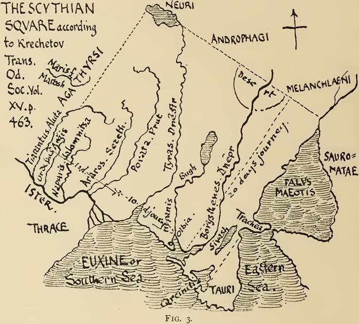
No one but Bruun[64] has doubted that the Tanais was always the Don or at any rate the Donets, and the Hyrgis would be the other branch now regarded as the true Don. Or this may well be represented by the Oarus which is almost certainly the Volga[65] in the upper part of its course: I mean that merchants following the trade route towards the ne. might well understand that the river they crossed above Tsaritsyn flowed into the Azov sea instead of making its sudden bend s.e. to the Caspian. The Tsaritsyn portage must have always been a place where trade was transferred from one river to the other. As to the Lycus and the Syrgis, which may or may not be the same as the Hyrgis, no one has given names to them so as to carry conviction ; the former may perhaps be the Ural. In later times there was such confusion[66] that the Caspian was represented to Alexander as being the same as the Maeotis[67] [68] [69] [70]. The question of the other rivers running into the Caspian is very difficult. On the west we have the Kur and the Aras now joining at their mouths, these are clearly the Cyrus and the Araxes properly speaking. In the mind of Herodotus there seems some confusion because the Armenian Araxes answers in direction (iv. 40), but neither in importance nor in position, to another Araxes upon which he puts (1. 201) the Massagetae; especially does it come short in the matter of its delta in which there should be islands the size of Lesbos (1. 202). This greater Araxes seems to be the Oxus or a running-into-one of the Oxus and Jaxartes[71]. The latest Grynaeus, Basileae, 1537.) 4 Strabo, XL vii. 4. 6 Stein will have but one Araxes, thought of by H. as running out of Armenia past the south coast of the Caspian into which it sends an arm, to marshes far to the E. The Scyths forced over the river would be Sacae invading Persia (cf. J. L. Myres op. cit.). Westberg (Klio, Beitr. z. alien Gesch. Bd IV. H. 2, pp. 182—192, Zur Topographic des Herodots) makes the Araxes of I. 202 the Volga and puts the Massagetae upon that, v. inf. pp. 111, 113 n. 3. investigations seem to shew that two thousand years ago the Caspian ran up a valley (the Uzboi) in the direction of the Aral sea and communicated with it by means of a lake or depression Sary Kamysh into which an arm of the Oxus flowed. Between this arm and the main stream going into the Aral sea there would be room for large islands[72] [73]. Further it is a question whether the Araxes mentioned (iv. 11) as having been crossed by the Scyths may not be the lower Volga, as it seems hard to think of them as ever having been south of the Oxus and displaced northwards by tribes coming from the east. If the Jaxartes were meant it would be just conceivable. They would find no satisfactory abiding place between the Jaxartes and the Don. We can never tell whether Herodotus be using Europe in the ordinary sense of the nw. quadrant of the old world or in his own special sense of the whole northern half. Seeing there are such difficulties in identifying the rivers, which must have remained substantially the same, we cannot hope to fix the place of the various Scythian tribes (cc. 17—20) with any accuracy: we can determine their relative positions but we have no idea of the relative extent of the lands they occupied and only one or two definite statements. We cannot even say whether the Georgi and Aroteres may not be the same people traversed and described by different travellers, and so too with the Nomad and Royal Scyths. On the modern map we may put the Callippidae quite close to Olbia: the Alazones have no boundaries that we can fix3, we may place them in the central part of the Government of Kherson, while the northern part of the same and some of Ekaterinoslav and perhaps some of Kiev were occupied by the Aroteres. These three tribes lay on one route from Olbia towards the north. To the west we only know of the Greek Tyritae about the mouth of the Dnestr : whether the same native tribes occupied the Hinterland and Rumania we cannot tell. Travellers towards the ene. from Olbia passed the Scythae Georgi occupying the valley of the lower Dnepr included in a belt three days journey wide and extending ten or eleven days upstream to about the borders of Ekaterinoslav. Hence they would seem to have been continuous with the Aroteres and very likely identical. That is to say the two names between them represent a congeries of tribes in the same more or less agricultural stage. The centre of Ekaterinoslav, by the great bend of the river, is the land Gerrhus which marches with the country of the Georgi and the Nomad Scyths. These with the Royal Scyths from which they cannot be clearly distinguished held the mainland part of Taurida, the western part of the land of the Don Cossacks, and probably also Kharkov and Vordnezh. The flat northern part of the Tauric peninsula, which Herodotus thought continuous with the mainland, also belonged to them as far as the slaves’ ditch, wherever that may have been. These eastern tribes lay on the route which led into Central Asia, and information about their lived where the Tyras and Hypanis come close together, which would be somewhere in Podolia, with the position of Exampaeus on their northern boundary, as this must have been further down stream (c. 52). position was hardly as definite as that about the central region north of Olbia. Indeed their position was perhaps indefinable; where the grass grew for their cattle, there was the land of the Nomad Scyths; as the most numerous and powerful tribe they did not need to respect their neighbours’ boundaries. BIBLIOGRAPHICAL SKETCH. Our ideas of the Geography of Scythia have gradually grown clearer. Thus we have slowly eliminated the views which brought the boundaries of Scythia well up into central Russia far beyond the limits of the Steppe, we have given up the attempt to bring Herodotus into agreement with the present condition of things by allowing great changes in the courses of the rivers and a former eastern extension of the Maeotis—our countrymen Rennell and Rawlinson were most ready for such explanations: we have forgotten such extravagancies as Lindner’s view that the Scyths proper were to the west of the Dnepr, or Kolster’s that Herodotus did not clearly distinguish between the Don and the Danube[74], or even more pardonable eccentricities such as Bruun’s, that the Tanais was not the Don, but the Molochnaja. ,π] Bibliographical Sketch 33 Most writers now agree as to the general orientation of the Scythia of Herodotus, but mention must be made of Krechetov’s ingenious view, which figures the Scythian Square as washed by the sea along the halves of two adjacent sides only: the remaining halves of those sides running inland along the lower Ister and the coast of the Maeotis, which he reckons a mere marsh and no sea1 (fig. 3). The square thus obtained with its corner at Cercinitis, placed by Krechetov at Donguslav lake in the Crimea, would be inclined slightly so as to have the E. sides facing ESE., so the sea along the south coast of the Crimea would be the eastern sea of c. IOO. But when translated into the terms of the correct modern map, it works out to have much the same real meaning as the more usual interpretations which count the Maeotis as a sea for the nonce. And after all, what is important to us is not the shadowy idea of Scythia that floated in the mind of Herodotus, incapable of being consistently represented on our map, but the real state of affairs of which Herodotus and Hippocrates give so interesting but so tantalizing accounts. Who wishes to follow the various attempts at drawing a map of Scythia ad rnentein Herodoti, or at disposing the ancient names about the modern map, may consult the following books as I have done. I omit the eighteenth century attempts as being controlled by too slight a regard for the geography of the regions concerned. BIBLIOGRAPHY. Rennell, James. The Geographical System of Herodotus examined. London, 1800. pp. 47—163. Map III. Niebuhr, B. G. On the Geography of Herodotus and on the History of the Scythians, Getae and Sarmatians. Oxford, 1830. = Kl. Sehr. Bonn, 1828. I. p. 132. Bobrik, Hermann. Geographie des Herodot. Konigsberg, 1838. pp. 84—123. Map VI. Dubois de Montp6reux, F. Voyage autour du Caucase. Vol. 1. Pl. 9. Paris, 1839 ; Neuchätel, 1843. Lindner, F. L. Skythien und die Skythen des Herodot und seine Ausleger. Stuttgart, 1841. ----- Skythien und die Skythen des Her.; Nachtrag (vin. Supplement-Bd d. Neuen fahrb. d. Phil., 1842). ----- Explication Nouvelle des donn^es g^ographiques d’Htfrodote concernant la Scythie (Annales des Voyages, 1845. I.). Nadezhdin, N. I. The Scythia of Herodotus explained by comparison with the localities. In Trans. Od. Soc. Vol. I. (1845), pp. 3—114. Ukert, F. A. Skythien. Being Vol. in. Pt 11. of his Geographie der Griechen und Romer. Weimar, 1846., Kolster, W. H. Das Land der Skythen bei Herodot und Hippocrates (Jahrbuch für Philologie und Pädagogik. Bd XII. 568, XIII. 1—77 (1846-7); also fahrb.f. Phil. u. Päd., LXXVI1. 331). Dumshin, G. Of the Rivers of Scythia according to Herodotus. In Publications of the Students of the Richelieu Lycee. Odessa, 1852. Blakesley, J. W. Herodotus with a Commentary. London, 1854. Wheeler, J. T. The Geography of Herodotus. London, 1854. pp. 137—170, 178—194. Neumann, K. Die Hellenen ini Skythenlande. Berlin, 1855. Abicht, K. Herodotos. Leipzig, 1869. Bruun, F. An Essay to reconcile conflicting opinions as to the Scythia of Herodotus and the lands marching with it. ist in Russian in ASH. Pt 11. St P. 1872. Next in French edition of the same. St P. 1873. Reprinted in Chernomorie. Vol. 11. pp. 1—120 and Map I. Odessa, 1880. Burachkov, P. I. On the Position of the ancient City of Carcinitis and its Coinage. In Trans. Od. Soc. IX., 1875. pp. i sqq. Zabelin, I. E. History oj Russian Life. Moscow, 1876. Vol. I. p. 227 sqq. Rawlinson, G. History of Herodotus, translated with notes. London, 1880. Vol. ill.’pp· 1— 114, 178—209. 1This is a fresh interpretation of των δύο μιρίων μ^σόγαιαν φίρον καί το παρά την θάλασσαν, Her. κατηκόντων is θάλασσαν, πάντη ίσον τό re er την IV. ΙΟΙ. Μ. Kiepert, H. Manual of Ancient Geography, Eng. ed. London, 1881. Bonnell, Ernst. Beiträge zur Alter thuniskunde Russlands. Bd I. St Petersburg, 1882. Bunbury, E. H. History of Ancient Geography. Ed. 2. London, 1883. Vol. I. pp. 172—217. Map IV. Voevodskij, L. F. Map of Scythia prepared for the vi. Russian Archaeological Congress (Odessa), 1884. Dzieduszycki, W. Information of the Ancients as to the Geography of Polish lands. (Polish) in Rosprawy i Sprawozdania z posiedzeh Wydziatu hist.-filozof. Akad. Krakow. T. XIX. 1887, p. 141 sqq. Lappo-Danilevskij, A. Scythian Antiquities. Trans. Russ. Arch. Soc. Slavonic Section. Vol. iv. (1887), p. 352 sqq. ’ Tomaschek, W. Kritik d. ält. Nachr. über Skythischen Norden. Sitzungsber. Akad. Wien, Phil. Hist. Cl. 116, 117. 1888. Krechetov, P. N. Letters on the Scythia of Herodotus; in Trans. Od. Soc. Vol. xv. (1889), PP· 457—495· ----- Boundaries and Outlines of the Scythia of Herodotus; in Drevnosti= Transactions oj Moscow Archaeological Soc. NcA. xm. (1889), p. 179. Latyshev, V. V. losPE. Vol. 11. St P. 1890. Map II. Macan, R. W. Herodotus, Bks IV.— VI. London, 1895. Krasheninnikov, Μ. Disposition of Ancient Scythia according to Modern Localities. Slutsk, 1895. Stein, H. Herodotos erklärt. Buch iv. 4te Aufl. Berlin, 1896. J. L. Myres. An Attempt to reconstruct the Maps used by Herodotus. Geographical Journal. London, viii. (1896), p. 605.. Mishchenko, Th. G. Ethnography of Russia according to Herodotus. Journ. Min. Publ. Instr. St P. 1896, May. ----- Information of Herodotus touching lands outside Scythia. Ib. 1896, December. Niederle, L. Descriptio Europae Regionum quae ad orientem spectant veterum scriptorum locis illustrata. Prag, 1899. ----- Slavonic Antiquities. Vol. 1. Pt 11. p. 215 sqq. Prag, 1904 (both in Cech). Braun, Fr. Investigations in the province of Gotho-Slavonic relations. 1. St P. 1899, pp. 69—99. Westberg, Fr. Zur Topographie des Herodots. Klio, Beitr. z. alten Gesch. iv. (1904), pp. 182—192. Shuckburgh, E. S. Heroaotos IV., Melpomene. Cambridge, 1906.
More on the topic CHAPTER III. GEOGRAPHY OF SCYTHIA ACCORDING TO HERODOTUS.:
- Minns E.H.. Scythians and Greeks. A survey of ancient history and archaeology on the north coast of the Euxine from the Danube to the Caucasus. Cambridge: University Press,1913. — 720 p., 1913
- Geography and Naming