17 Zaporozhia
The center of the Zaporozhian Cossacks was called the sich. This was a fortress protected in part by high walls of wood and by lowland swamps that were tucked in between the many tributaries just south of the rapids in the Dnieper River.
Actually there was not one but several siches, which existed at different times and at different places along the river. The displacement of the sich generally reflected the need for the Zaporozhian Cossacks to adapt to threats from the powers that hoped to control them.Initially, the Zaporozhians recognized the hetmans appointed by the Polish king to command the registered Cossacks stationed in towns farther to the north. It was one of those hetmans, the Rus’ Prince Dmytro Vyshnevets’kyi, who in 1552 had the first sich built on the Little Khortytsia Island located beyond the ninth and southernmost of the Dnieper rapids. Both Little Khortytsia Island and the larger Khortytsia Island are remembered as the first historic centers of the Zaporozhian Cossacks.

17.1 One of the nine rapids in the Dnieper River, all of which were submerged following the creation of river reservoirs in 1932.
MAP 17 ZAPOROZHIA

After 1558, when Tatar raiders destroyed the Cossack stronghold on Little Khortytsia Island, the location of the sich generally moved further southward: Tomakivka (1564-1593), Bazavluk (1593-1630), Mykytyn Rih (1628-1652), and, during the height of Cossack statehood, what became known as the Stara Sich (1652-1709). When, in 1709, a Muscovite army destroyed the Stara Sich, the Cossacks were forced to abandon Zaporozhia altogether and to create their sich under the protection of the Ottoman Empire (with whom they were temporarily allied) at Oleshky (1711-1734) near the mouth of the Dnieper River (see also Map 23).
In 1734, when the Cossacks were allowed to return to Zaporozhia (by then under the hegemony of the Russian Empire), they established the Nova/New Sich. This lasted until the Russian Empress Catherine II ordered the destruction of the Nova Sich in 1775 and the permanent dispersal of the Cossacks from Zaporozhia.
17.2 Prince Dmytro Vyshnevets’kyi (d. 1563), referred to in folklore as Baida, organizer of the Zaporozhian Cossacks.
Behind the walls of the sich, wherever it was located, were the living quarters for resident Cossacks. The central square (maidan), where the Cossack brotherhood held its general meeting (rada), also contained a church, a school, and a residence for the leadership. The head of the Zaporozhians was at first simply called the elder (starshyi), and later the kish or koshovyi otaman. When, beginning with the 1590s, the Zaporozhians no longer recognized the hetmans appointed by the Polish king from among the town Cossacks, the sich council (rada) would at times of general mobilization elect their own hetman.

17.3 Little Khortysia/Mala Khortysia Island just below the ninth rapids in the Dnieper River, site of the first Zaporozhian Cossack fortified center, or Sich (1552-1558).
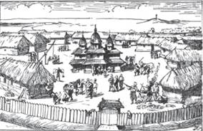
17.4 The Zaporozhian Sich in the 17th century.
Only men were permitted inside the sich, where at times their numbers reached as high as ten thousand. Married Cossacks with their families as well as free homesteaders resided in the surrounding countryside of Zaporozhia along both banks of the Dnieper River, where they earned their livelihood from fishing, hunting, raising cattle, and agriculture. Just beyond the sich walls was a market square (bazar), where goods from cities and fortified centers farther north (Kiev, Kaniv, and Cherkasy; see Map 16) were traded alongside products from the Crimea and Ottoman lands to the south. For most of its history, the largest percentage of Zaporozhian Cossack foreign trade was not with Poland-Lithuania or with Muscovy, but rather with the Crimean-Ottoman markets to the south.

17.5 The Kichkas Ford across which an important trade route led southward from Zaporozhia to the Crimean Khanate and Ottoman Empire.