Croghan to Kiltober
The landscape between Croghan and Kiltober is dominated by limestone till and cutover bog, with rock on the hills and occasional alluvium in the lowlands, but the western side is made up of limestone sands and gravels with a very substantial esker (Fig.
6.6). The Rahugh Esker is an excellent example of a steep-sided, single-crested esker, and it was evidently an important landscape feature as it creates the townland boundary between Kiltober and Monasset, and the other townlands which flank it. This is an important part of the esker, as it marks the point where the eskers become well defined and lengthy. Eskers north and east of this point are of short and more dispersed character, and as such are less useful for paths or boundaries. It also marks where the Slighe Mor intersects with the Midland Corridor, making it a crossroads of two major routeways. The importance of this intersection is demonstrated by the distribution of barrows in prehistory and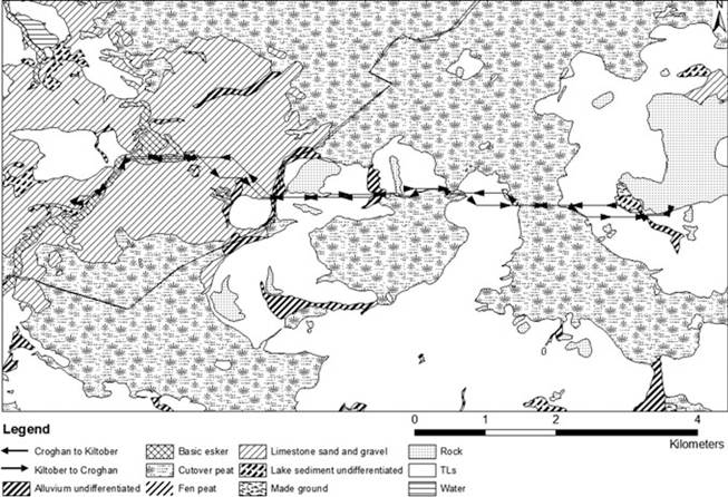
Fig. 6.6 Croghan to Kiltober Least Cost Path and soils
ringforts in the Medieval period, particularly in areas with limestone sand and gravel subsoil, west of the esker.
Clonearl Bog and Raheenmore Bog are located between Croghan and Kiltober, and these must be negotiated to move between the settlements. A series of low hills lie between Croghan and Kiltober, at Oldcroghan, Kilduff, Clonagh and Mul- lagharush Hill, which flank the narrowest points of the bogs.
6.5.1 Least Cost Path Results
The Least Cost Paths for this segment similarly traverse the bogs at the narrowest points available without deviating course more than a few degrees (Figs. 6.6 and 6.7). Clonearl Bog is crossed at the narrowest point, which is defined on the east side by a rise in Oldcroghan, and on the west by Kilduff Hill.
The paths skirt the southern base of Clonagh Hill and Mullagharush Hill, and cross Raheenmore Bog where it narrows to only 10 m, which probably marks a patch of ground which was dry land until recent centuries. The hills mark the most convenient crossing points, but they are only climbed as much as is necessary to gain dry land. The esker is climbed at a suitably gentle point on its northeastern extent, after which this level, single-crested esker leads directly to Kiltober.
Fig. 6.7 Croghan to Kiltober
6.5.2 Agent-Based Modelling Results
The journey from Croghan to Kiltober requires the crossing of Clonearl Bog and Raheenmore bog. The leader finds the narrowest points in these bogs, which is the same as the crossing points suggested by Least Cost Paths (Fig. 6.7). The model deviates from the ArcGIS version on the western extent where the esker is accessed. The model does not include in-built preference to the esker subsoil type, but is controlled in this context by slope. The leader, when moving from east to west, does not move northwest to climb the esker, as the Least Cost Path model shows, but crosses the esker much closer to the target. The final follower crosses the esker 132 m from where an existing road transects the esker. This coincides with a slight drop in the contours east of the esker, which naturally direct movement to this point.
6.5.3 Archaeological Evidence
Clonearl Bog is most recognised for the Iron Age bog body found there in 2003. Oldcroghan Man, as he is known, was found 1.3 km southeast of the proposed crossing, where the bog is at its widest (Plunkett et al. 2009). As discussed above (Sect. 6.2.2), activities in the bog can be separated between those which treat the bog as an obstacle and those which treat it as an objective. The deposition of Oldcroghan Man was a ritual activity and it is no surprise that it should take place in a different location to simple negotiation of an obstacle.
However, it is indicative of activity in the area, from which we can assume movement took place in the Iron Age.The archaeological evidence in this segment is minimal. The paths pass a ring barrow in Oldcroghan and do not encounter any further known archaeology until in view of the esker. The most compelling evidence supporting the potential paths is their similarity to the existing road network. The predicted paths closely correlate with existing roads at the Raheenmore Bog crossing and along the southern slopes of Clonagh and Mullagharush Hill. The paths from both models are very similar in this segment. Except for the more obvious deviation on the western extent, they follow the same general corridor of movement with paths separated by a maximum distance of only 250 m. It is clear that major obstacles, such as the bogs, produce the most uniformity between the models and the existing road network.
The Rahugh esker is associated with a flanking road on the east side, and the presence of two castles along its course suggests the esker itself was used as a path in the Medieval period, with the earlier of the castles dating to the late 12th or early 13th century. A standing stone sits 220 m from the esker, which implies a significance to this landscape feature in prehistory also. The linear nature of the esker makes it an ideal feature by which to maintain orientation and to pilot by. Travelers can rely on such a feature to plan movement from a distance in this fashion, but it also acts as a suitable surface to walk over. The height which it offers provides a means of seeing some distance and planning a journey accordingly, while also being well-drained and linear.
6.6
More on the topic Croghan to Kiltober:
- Rhode to Croghan
- Boon Andrew. The Ethics and Conduct of Lawyers in England and Wales. Hart Publishing,1999. — 808 p., 1999
- Griffiths-Baker Janine. Serving Two Masters: Conflicts of Interest in the Modern Law Firm. Hart Publishing,2002. — 227 p., 2002
- Grisso T.. Evaluating Competencies: Forensic Assessments and Instruments. 2nd edition. — Springer,2002. — 564 p., 2002
- Luban David. Legal Ethics and Human Dignity. Cambridge University Press,2007. — 350 p., 2007
- Ayupova Z.K.. Theory of state and law: textbook. - Almaty: Kazakh University,2015. - 192 pages., 2015
- Allen Danielle, Benkler Yochai et al. (eds.). A Political Economy of Justice. The University of Chicago Press,2022. — 416 p., 2022
- Barnes Rudolph C.. Military Legitimacy: Might and Right in the New Millennium.Frank Cass,1996. — 198 p., 1996
- Bedner Adriaan (ed.).. Real Legal Certainty and its Relevance: Essays in Honor of Jan Michiel Otto. Leiden University Press,2018. — 261 p., 2018
- Fridson M., Alvarez F.. Financial Statement Analysis. John Wiley & Sons, Inc.,2002. — 413 p, 2002
- Banking, Finance, and Accounting: Concepts, Methodologies, Tools, and Applications. IGI Global,2014. — 1593 p., 2014
- Hare C., Neo D. (eds.). Trade Finance: Technology, Innovation and Documentary Credit. Oxford University Press,2021. — 417 p., 2021
- Fligstein Neil. The Banks Did It: An Anatomy of the Financial Crisis. Harvard University Press,2021. — 334 p., 2021
- Cline W.. The Right Balance for Banks. Peterson Institute for International Economics,2017. — 281 p., 2017