Rhode to Croghan
The settlements of Rhode and Croghan in the northeast of Offaly occupy slight elevations which are surrounded by a series of hills of volcanic origin and are separated by Ballybeg Bog (Fig.
6.4). O’Lochlainn (1940) tells us that the Slighe Mor linked these two settlements in the Early Medieval period, so a routeway must have existed between them despite the obstacle of the bog. Clonin Hill, which overlooks Rhode, is topped with a large Bronze Age ring barrow, while Croghan Hill is the location of an extremely prominent burial mound. The dating of this monument is uncertain, but the lack of an external ditch may suggest that it is a Neolithic cairn, rather than a Bronze Age barrow. Within the bog itself, the remains of Late Neolithic and Early Bronze Age occupation have been found. Minor secondary and tertiary trackways are present which do not appear to have crossed the bog, and they seem to have been intended to access a particular part of the bog, probably the ancient Lough Nashade (Irish Archaeological Wetland Unit 2002e). As discussed (Sect. 6.2.2), trackways leading into the bog are characteristically different to those which are intended to cross it. The presence of a contemporary bow stave (Murray 2004) suggests these trackways were probably associated with hunting within the wetlands, and so they do not provide an answer for how the bog may have been crossed. However, the site of the existing road which crosses the bog may conceal earlier trackways. Indeed, it is known as the Togher of Croghan and documentary evidence from the Annals of the Four Masters suggest it is at least 600 years old (Lucas 1985). The presence of prehistoric archaeology in this area demonstrates a prolonged use of this landscape, and the two areas of occupation on either side of the bog, represented by the burials and highly visible hills at Rhode and Croghan, would have to have been linked by a routeway to facilitate this. The presence of Late Neolithic and Early Bronze Age archaeology in particular suggests a routeway may have existed here at that time.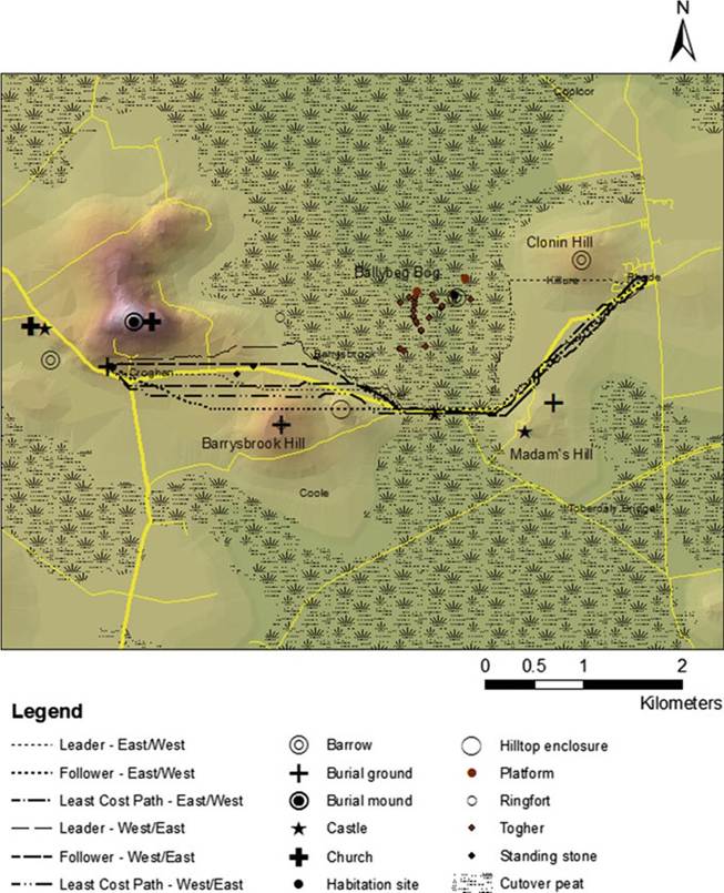
Fig. 6.4 Rhode to Croghan
6.4.1 Least Cost Path Results
The Least Cost Paths predictably traverse the bog at the narrowest point (Fig. 6.4). This point is flanked by Madam's Hill in Toberdaly, on the east side of the bog, and Barrysbrook Hill to the west. The paths skirt the lower slopes of these hills, using their elevation and drainage to emerge onto suitably dry land from the bog. It is not necessary to climb more than a few metres to access dry ground, and the steep slope and higher values for the exposed rock are thus avoided.
6.4.2 Agent-Based Modelling Results
A direct path from Rhode to Croghan and vice versa would traverse Ballybeg Bog at an unsuitable crossing point, so the leader is obliged to search for a narrower point, which it finds between Toberdaly and Barrysbrook, in the same location as the Least Cost Path (Figs. 6.3 and 6.4). Each follower is able to shorten the path to the crossing point, leading to an eventual path which makes straight for the crossing, with minor corrections made for slope. With the bog crossing complete, the remainder of the trip is unimpeded and a relatively straight route can be taken to the target.
6.4.3 Archaeological Evidence
The path taken by both programs through Ballybeg Bog coincides with the existing roadway which crosses this obstacle. A map dating to c. 1563 illustrates this crossing point as a causeway between Cnocarderin and a series of hills east of Croghan (Fig. 6.5). The feature is labelled as a togher and depicted as being defended by a castle, demonstrating the strategic importance of this crossing (see
Fig. 6.5 Togher of Croghan. With permission © The British Library Board. Cotton Augustus MS I ii 40. North to right of image
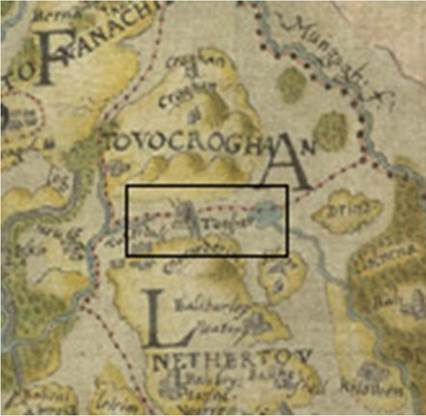
Irish Archaeological Wetland Unit 2002a for discussion of the location of this castle). The Togher of Croghan, or Tochar Cruachain Bri Eile, is mentioned in the Annals of the Four Masters at least as early as 1385 (Lucas 1985), so the current roadway, and the path suggested by the modelling, mark a crossing of some antiquity.
Given the prehistoric archaeology in the area, it would be likely that this crossing would have been exploited at an earlier date also.The road separating Croghan Hill and Barrysbrook Hill appears to be closely related to the paths suggested by the modelling (Fig. 6.4), and was once flanked by two standing stones, of which one still survives. Standing stones are sometimes associated with routeways, but this road dates back only as far as the 19th century. An older road circles south of Barrysbrook Hill, before meeting a crossroads by which one can move north towards Croghan. When crossing Ballybeg Bog, it is clear that the series of hills which make up this landscape (Clonin Hill, Madams Hill, Barrysbrook Hill and Croghan Hill) create visual cues to pilot by when navigating the terrain. In particular, the targets on either side of the map are towards a low point on the slope, offering a suitably dry area for comfortable walking without an unnecessarily high climb, and providing an ideal vantage point to view the ground ahead. With this in mind, it would make no sense in terms of navigation and energy consumption to move south of Barrysbrook Hill to reach Croghan, obscuring Croghan Hill and adding needless distance to the journey.
There are a number of reasons why this circuitous route may exist. The road south of Barrysbrook is a better option for travelers bypassing Croghan in favour of Kilclonfert, 5.5 km to the west. This is another Early Christian site which was reputedly on the Slighe Mor and which was prestigious enough to be decorated with Romanesque features in the 12th century (Fitzpatrick and O’Brien 1998). In addition to this, the current road bisects the lands of Croghan Demesne, while the older road clearly adheres to its southern boundary. Movement through these lands would have been discouraged in the lifetime of the demesne, necessitating a different route which respected the boundary. Prior to this, Croghan was a royal site through which rights of movement would similarly have been carefully controlled.
Despite the later date for this section of the existing road, the compelling trajectory which the landscape impresses on the traveler through visual cues and landmarks suggests that there ought to have been a routeway here if movement between Rhode and Croghan took place. The standing stones are the best evidence for the existence of this route and, along with the modelled paths which move between the hills and associated monuments; they demonstrate that a path is likely to have existed in this location. Indeed, this path and the ritual landscape created by the burial mound on Croghan Hill and the standing stones below it may have been the impetus for the development of this landscape as a royal site.
The Togher of Croghan is a crucial point in the landscape because of its role in crossing Ballybeg Bog which would lead to its emergence as a place in its own right. This is demonstrated, not just from its depiction in the historical map of Leix and Offaly, but by its association with a castle. The Agent-Based Model shows turtles later in the sequence move directly towards this crossing point. It is clear that the Togher of Croghan becomes more than simply an interim point in the journey between Rhode and Croghan, but emerges as a place of note in the landscape which would appear in the cognitive maps of those who made use of it. By viewing the landscape in this movement-centric way, it may be possible to reconstruct how the people occupying it in the past constructed their cognitive maps.
6.5