Founding and Growth of the Empire
Ironically, there are no contemporary documents for the most important event that ever occurred in the history of mainland Southeast Asia: the founding of the Khmer Empire. In southeast Thailand at the site of Sdok Kak Thom (SKT), a stela inscribed in Sanskrit and Khmer and dating to 1052 ce contains the relevant data, buried in the lineage history of an important family of hereditary purohitas (house chaplains to two centuries of Khmer king-emperors, beginning with the first).
This story concerns a ruler known to us as Jayavarman (“Protected by Victory”). The SKT inscription states that he came from some place called “Java,” but most scholars think that it cannot be the island of that name. He was a man of great military prowess. At first, Jayavarman II and his followers seized the principality of Vyadhapura in southern Cambodia, following which he carried out a series of successful invasions of other polities up the Mekong to the north, all the way to the sacred city of Wat Phu in what is now southern Laos, and then northwest to polities in contemporary Thailand. Most significantly, he took possession of Hariharalaya, a short distance north of the Tonle Sap (the Great Lake) and southeast of what was to become Angkor.
Eventually, the otherwise victorious Jayavarman II seems to have been beset by enemies who had revolted against his rule (temporarily, as it turned out), so he took refuge on Phnom Kulen, the low range of hills from which the builders of Angkor were to derive all of the sandstone used in their temples and sculptures. Known anciently as Mahendraparvata, these hills and the small city that they supported were also the source of numerous watercourses that ran south to the Tonle Sap. One of these rivers, the Siem Reap, became known to the Khmer as the Ganga, the sacred Ganges in far-off India. In 802, standing atop a small brick pyramid on Phnom Kulen, Jayavarman II was consecrated by his purohita as a chakravartin, a universal ruler.[1240] As the SKT text put it, “to ensure that the country of the Kambujas would no longer be dependent on Java and that there would be no more than one sover- eign.”[1241] Jayavarman II, having re-exerted his control over most of Cambodia, then established the capital of his new empire at Hariharalaya, 55 kilometers (33 miles) southeast of the center of what would become Angkor.
The “Harihara” of the name bespeaks unity, the blending of the attributes and powers of the two gods most important to Cambodian rulership: Vishnu (Hari) and Shiva (Hara).There one of his successors, Indravarman I (877-ca. 889) initiated a pattern of public and religious works that was to characterize the reigns of the empire's most powerful sovereigns:
• the erecting of—or improving of—a state pyramid-temple, in this case the sandstone-clad Bakong, the whole surrounded by a moat;
• temple shrines dedicated to his immediate ancestors;
• the construction of an immense, rectangular baray (reservoir), known to us as the Indratataka (the “Sea of Indra”).
Indravarman I subsequently carried out conquests in southern Cambodia and added the Khorat Plateau to the north of the Dangreks to the empire.
Later kings extended the empire. Yashovarman I, “Protected by Glory” (r. 889- ca. 900), took the step of moving the capital northwest to Angkor, naming this city Yashodharapura (“City of Glory”), and leveling the summit of the Bakheng, a low hill, to build his state temple; like almost all such temples in the kingdom, it was dedicated to the god Shiva, the protector of the ruling house, and symbolized the holy Mount Meru in the distant Himalayas, the dwelling place of the Hindu gods. The name by which we now know the city, Angkor, is a Khmerized version of the Sanskrit nagara, “capital city.”
Scholars have shown that the extent of Yashovarman's empire is indicated by the distribution across the realm of ashrams (small wooden hermitages) and their stele inscribed in Sanskrit. In his day it included all of Cambodia and part of the Khorat Plateau. But as Jacques and Lafond[1242] have emphasized, in Angkorean times—at least before the reign of Jayavarman VII, “the empire was never a monolithic entity, but rather a grouping of vassal fiefdoms, not necessarily adjacent, thus allowing the possibility of a degree of independence in the intermediate zones.”
Another tempering factor that affected the consolidation of these entities into a single state is the complexity of dynastic succession and royal descent.
Rulership very often did not pass from father to son, but to a brother, or to another male in the same generation, but given the large-scale polygamy practiced by all Cambodian kings, half-brothers or cousins would sometimes resort to civil war to establish their right to rule. The various branches of royal descent formed what Vickery has called “conical clans,” defined as clans in which all members are ranked hierarchically in terms of their relationship to the common ancestor, real or putative, who may merge with a god.[1243] Small wonder that there was often turmoil when a king died. Nevertheless, such Darwinian struggles resulted in sovereigns who could display a high degree of fitness for war or peace.One of the mysteries of Khmer history concerns Jayavarman IV (ca. 928-941). For reasons unknown to us, he moved the imperial capital 90 kilometers (45 miles) northeast to Koh Ker, which is situated in a somewhat dry and barren part of the Cambodian lowlands. It may have been its ready access to rich sources of iron and copper ores, and gold, that gave Koh Ker its prosperity, resulting in a flowering of large-scale, three-dimensional sculpture, as well as the loftiest state temple ever built by the Khmer: the Prasat Thom, a seven-story stepped pyramid. Just as impressive is Koh Ker's large baray (reservoir), cut down into the living rock rather than embanked with earthen dykes like those of Angkor.
Following Jayavarman IV's death, the capital returned to Angkor. After a series of kings, by 1002 there were two claimants to the throne: Jayavirvarman and Suryavarman I (1002-1049). The claim of Suryavarman (“Protected by the Sun”) was based on his descent from a chief queen of Yashovarman I; tenuous as this might have been, he overpowered his rival and reigned over the empire for almost four decades.[1244] To firm up his rule over the entire empire, he called 4,000 of his officials to the capital to swear an oath of allegiance, sealed in blood.
This loyalty oath was still in use in the Cambodian capital as late as the twentieth century!One of his most important acts was to establish the administrative limits of his realm by placing an inscribed linga (a stone phallus representing Shiva, the tutelary divinity of kings) on the boundary temples at each of the four directions. In the west, this was at Wat Ek, near the town of Battambang; in the north, on the Dangrek escarpment at the extraordinary temple of Preah Vihear (recently the subject of a violent confrontation between the Cambodian and Thai armies); on the south by Phnom Chisor, at the head of the Delta; and on the east, by an as-yet unidentified temple near the Mekong. A rough calculation would suggest that Suryavarmans powers were exerted over about 114,700 square kilometers (44,286 square miles)— an empire no larger than the state of Ohio! It would appear that Khorat north of the Dangreks was then virtually autonomous from the rule of Angkor. The four kings who followed Suryavarman I to the throne seem to have done little to expand this diminished realm.
The great ruler Suryavarman II (1113-ca. 1150) was of far different mettle than his immediate predecessors and must be regarded as one of the outstanding figures of Cambodian history. It is to him that we owe his state temple, the magnificent Angkor Wat, often held to be the largest religious structure in the world; dedicated by Suryavarman to the god Vishnu, it is entered from the west over a causeway that crosses over an immense, rectangular moat. Apart from its beautiful quincunx of temple towers, Angkor Wat is renowned for its three concentric galleries, one of which is completely carved on its four inner surfaces with magnificent bas-reliefs. On one of these reliefs (Figure 15.2), depicting Suryavarmans court and his army on a jungle march, the monarch is carrying out his review, seated on a palanquin throne under multiple umbrellas of honor—one of the very few portraits that we have for any Khmer sovereign until the arrival of the French in the mid-nineteenth century, with their photographic gear.
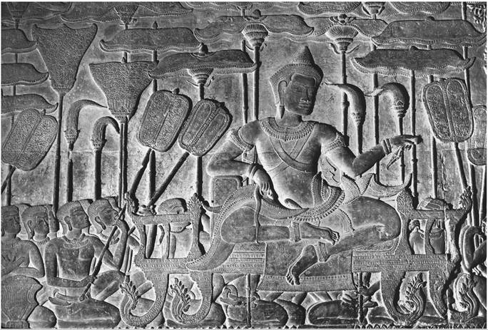
Figure 15.2. Suryavarman II (r. 1113-ca. 1150 ce), enthroned among courtiers. Detail of a relief at Angkor Wat.
Photo: Michael D. Coe.
A recent airborne LIDAR survey has shown that, away from the temple's outer walls, the artificial moat-surrounded “island” on which the temple sits was a miniature “city within a city” laid out on a rectangular grid. It may have been inhabited by state and religious officials and their families.[1245]
During his reign, the empire regained its control over the Khorat Plateau, as evidenced by the impressive temple center of Phnom Rung, located on an extinct volcano some 30 kilometers (18 miles) north of the Dangreks. In fact, Suryavarman extended his powers as far as the border of Pagan in Burma (Myanmar), and south to the Malay Peninsula.
Suryavarman II pursued an aggressive, proactive policy with the empire's neighboring states to the east and northeast, particularly the Cham. In 1128 and again in 1132, with the support of the Cham kings, the combined Khmer-Cham forces attacked Dai Viet (the Vietnamese kingdom, fresh from achieving independence from China), but met with disaster. The Khmer imperial army invaded Champa in 1150, but once again suffered defeat, this time by the Cham.