Introduction
This paper is part of a wider research project which aims to understand how people in the past exploited natural routeways and manoeuvred around obstacles in the landscape. The archaeological evidence from North Offaly in the Irish midlands is the principle case study used to explore this question (Fig.
6.1). Segments of a known, but poorly defined, ancient routeway within the study area are discussed in this paper, with the objective of identifying a likely routeway using computer applications, supported by fieldwork and documentary sources. Routeways can wax and wane in importance depending on factors such as settlement, expressions of control or technology, but this paper aims to describe how people interact with the natural features of the landscape in a cumulative fashion to form routeways. This concept can be applied to any landscape or period, with the caveat that certain ritual practices, taboos or cultural rivalries also have an effect on how movement is performed. The case study in question, however, incorporates evidence ranging from the Neolithic period to as late as the 16th century, when the Tudors drastically altered the landscape through widespread clearance of woodland.Two digital approaches are used, namely Least Cost Paths to calculate a routeway, and Agent-Based Modelling to grow (Epstein and Axtell 1996) one. ArcGIS 9.3 is used in what is considered a routine method to identify potential routes through the application of Least Cost Paths. NetLogo 5.1.0. (Wilensky 1999) is used to emulate individual actions of heterogeneous agents which cumulatively contribute to the evolution of routeways. Least Cost Path procedures have gained
Y. O'Brien (s) · S. Bergh
National University of Ireland, Galway, Ireland
e-mail: y.obrien2@nuigalway.ie
S. Bergh
e-mail: stefan.bergh@nuigalway.ie
© Springer International Publishing Switzerland 2016 199
J.A.
Barcelo and F. Del Castillo (eds.), Simulating Prehistoric and Ancient Worlds, Computational Social Sciences, DOI 10.1007/978-3-319-31481-5_6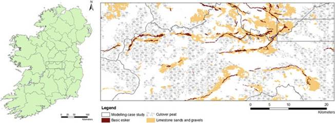
Fig. 6.1 Location of study area and modelling case study area
popularity in archaeological landscape studies since the 1990s, and particular attention has been paid to how it might be performed without reducing the role of people in the landscape to passive individuals with no autonomy or agency. In fact, it is quite possible to create a Least Cost Path based on genuine human decision, as the values assigned to these models are derived from legitimate factors which influence movement, such as distaste for steep slopes, the relative difficulties of traversing different soil types, and absolute obstacles. As Llobera (2000) observes, ‘Topography is basic for it is always present and its influence is continuous in every landscape. Hence it constitutes the background on which other factors operate.' Social factors need not be ignored either, and taboos, traditions, exclusivity etc. can also be easily incorporated into such models by increasing or decreasing values as appropriate. Agent-Based Modelling makes this decision-making process explicit, as each action performed by the agents involves a decision based on the environment, informed by any number of physical, social or cultural factors.
While Least Cost Path procedures are ideal for identifying the optimal path through a landscape, agents on the ground are not exposed to the level of global information which is used to calculate the path in this way. Modelling allows us to investigate the overall evolution of a routeway as individual agents have access only to local information, allowing them to approach the optimal path over time through a process of iterative attempts to traverse a landscape.
The outputs from Least Cost Paths and Agent-Based Modelling may be used to point to parts of the landscape that merit further research in the field and through documentary sources. Existing archaeological and documentary evidence such as extant monuments, lines of sight and records of roads can support the potential of the modelled routeways. By comparing the hypothetical and the physical in this way, the parameters of both models can be improved in the hope of finding a useful methodology for areas without such rich records.
6.2