The Study Area
The landscape of North Offaly is dominated with esker, bog and, in the past, extensive natural woodland (Fig. 6.1). An esker is a long, sinuous ridge of sand and gravel, which are the remains of deposits left by rivers of melt-water beneath the surface of glaciers 15,000 years ago.
In Ireland, a series of these ridges stretches from the east coast to the west coast and are known by the collective name of the Eiscir Riada. Some of the finest examples of high-sided and single-crested eskers are found in the study area (Tubridy and Meehan 2006). The bogs, which are slightly younger, began to form about 10,000 years ago as glacial retreat filled dips and valleys with nutrient-rich meltwater. Poor drainage caused these shallow lakes to build up with partially decomposed plant material and eventually, as they changed from being fed by ground water to rain water, they grew into the typical dome shape of raised peat bogs. The Irish midlands are renowned for their raised bogs, often referred to in the singular as the Bog of Allen, and a number of archaeological surveys and excavations have demonstrated their importance since early prehistoric times (Moloney et al. 1995; Irish Archaeological Wetland Unit 2002a, b, c,d, e; Irish Archaeological Wetland Unit 2003a, b, c; Whitaker and O'Carroll 2009). A stretch of dry land, known as the Midland Corridor (Smyth 1982), bisects this landscape in a northeast by southwest orientation, acting as a major inter-regional routeway and valuable agricultural land. When Ireland was populated by Mesolithic hunter-gatherers around 8000 BC, the eskers were already in place, but many bogs were still in the early stages of development as lakes or reed swamps. Nevertheless, they were an important feature in the landscape which impacted on the execution of movement, and both of these landscape features have influenced human activities since the arrival of the first settlers in Ireland.6.2.1 Eskers
The eskers, being well-drained, elevated, relatively straight, and flanked by wetlands, are quite suitable for movement, as is clear from the number of trails and roads currently located on these ridges (Fig. 6.2). The Early Medieval routeway known as the Slighe Mor, which is associated with the birth of King Conn Cead- cathach and therefore usually dated to the early 2nd century AD, is defined for much of its course by the Eiscir Riada. From the Early Medieval period onwards, there was a considerable increase in the amount of ecclesiastical settlement in particular along the course of the eskers. It appears that the Midland Corridor would have been a more important inter-regional routeway in prehistory, while the esker probably functioned as a local routeway. The bogs would have been wetter early in their developments, and the eskers would have been attractive features in the attempt to negotiate them. This attraction is demonstrated by the presence of standing stones and burials in proximity to the eskers, suggesting a prehistoric importance to these features.
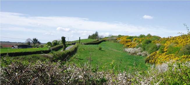
Fig. 6.2 Roads often follow esker ridges
6.2.2 Bogs
While bogs are obstacles, they are not necessarily impenetrable if one is prepared to invest time and energy in the construction of a trackway. Archaeological investigations have revealed numerous timber trackway constructions in these wetland locations ranging in date across prehistory and the medieval periods (Moloney et al. 1995; Irish Archaeological Wetland Unit 2002a, b, c, d, e; Irish Archaeological Wetland Unit 2003a, b, c; Whitaker and O’Carroll 2009). This suggests that there were incentives to traversing the bog, rather than diverting around it on to dry land. The principle incentive would most likely have been the saving of time and energy by substantially shortening a journey. The initial effort of constructing the trackway would be very quickly offset by the ease with which subsequent crossings could be taken.
The trackway may have been periodically maintained or replaced as the bog would continue to grow, and this often results in a succession of trackways over a prolonged period. Edercloon, Co. Longford, for example, revealed 48 structures in an area which measured only 170 m by 30 m, demonstrating a consistency of movement in this area from the Neolithic to the Medieval period (Moore 2008). This persistency of construction and consistency in crossing the bog at the same location makes the crossing point a place of relevance and an active node in the landscape. Typically, trackways traverse the bog at narrow points, although exceptions exist, such as Ballybeg Bog within the study area, or Mountdillon Bog, Co. Longford. Examples such as these are sometimes speculated to be for ritual purposes, or perhaps local access to resources within the bog. This indicates the trackways can be divided into two categories, those crossing the bog which treat it as an obstacle, and those accessing the bog which treat it as an objective.6.2.3 Hills and Landmarks
The terrain throughout the North Offaly is relatively flat, ranging from 40 m OD around the River Shannon basin in the West, to 90 m in the East. Apart from Croghan Hill, with a height of 234 m, most rises are quite low, but nevertheless highly visible. The practice of navigating through a landscape is most often done by moving in reference to landmarks in a process known as piloting. Hills and other highly visual features tend to act as landmarks to pilot by, and facilitate the development of cognitive maps (see Golledge 2003 for full discussion). While individuals are typically only exposed to local information, hills are a means of introducing more global information, by offering distant landmarks to pilot by, and by offering a vantage point to assess more distant terrain. Such locations are frequently mythologised and ritualised, demonstrating the importance of these places to sense of place. In the landscape of North Offaly in particular, rises are often found either side of narrow points in the bogs, meaning they are found at the most appropriate crossing points.
As such, they are attractive features to travelers who seek to cross a bog, observe the landscape, and plan a journey.6.2.4 The Slighe Mor
The Slighe Mor routeway is often described as following the course of the Eiscir Riada, but the “esker” is in fact a series of multiple, discontinuous and sometimes parallel ridges, which make it quite difficult to define the exact course of the routeway. A number of suggested courses have been described (O'Lochlainn 1940; Fitzpatrick and O'Brien 1998; O'Keeffe 2001; Geissel 2006), and each suggestion almost certainly represents places where movement took place. However, it is not the intention of this research to identify the exact path of the Slighe Mor. In fact, it is perhaps more appropriate to think of the Slighe Mor as a concept, rather than a fixed path, and the name may have been applied to several paths at different, or even simultaneous, times. Rather, the itinerary produced by Colm O'Lochlainn (1940) for the Slighe Mor is used as a list of nodes between which movement demonstrably happened. O'Lochlainn produced this itinerary through a study of documentary sources and mythologies which record the travels of historical and mythological characters. While exact paths were not recorded, settlements along the way were named. Models are run between these locations in order to understand how movement may have taken place between them. Within the study area, O'Lochlainn describes the Slighe Mor as passing through Rhode, Croghan, Kil- tober, Durrow, Ballycumber, Togher, Ballaghurt and Clonmacnoise. The records usually refer to ecclesiastical settlements, so ecclesiastical sites were chosen, where possible, as the sources and destination points. For locations without a suitable ecclesiastical site, castles were chosen as nodes as they were often placed in reference to routeways.
6.3
More on the topic The Study Area:
- Diagnosis of Bovine Tuberculosis in Zambia
- Bovine Tuberculosis (BTB) in Cattle in Zambia
- Introduction
- Public and professional ideas about ecology often differ
- Bovine Tuberculosis in Zambian Wildlife
- Reviewers
- Introduction
- Pelvic bones and fetal skull
- Algert Nance, Rogers Kenita S.. Conflict Management and Dialogue in Higher Education. Information Age Publishing,2020. — 227 p., 2020
- GREEN UNPLEASANT LAND