Introduction
From the archaeological investigation of findings in peat-bog and lake-shore sediments in the North-Western pre-alpine forelands, it is known that people built their wooden houses in these locations from the 5th to the first Millennium BC (Menotti 2004).
In more than 150 years of interdisciplinary research, detailed knowledge has been gained from the excavations and analyses of the oxygen-depleted layers and the remains of wooden houses. However, a remarkable gap exists between highly resolved knowledge on certain issues, and some very fundamental, yet unsolved questions. Thus, it is known exactly which plant and animal species have been consumed (Jacomet 2009), but the husbandry and land use methods are contradictory discussed (Ehrmann et al. 2009; Bogaard 2002).Evidence is for a highly dynamic settlement system and a short occupation time of many sites, yet the reasons are as unclear as the feedback mechanisms inside of the system (Ebersbach 2010). One reason for this disparity might be conditioned by the biased distribution of evidence that is concentrated in waterlogged locations. Inside of the sites, a lot of condensed information is stored, and in many cases, settlement structure, house architecture and consumption or production modes can directly be assessed from the excavations (e.g. de Capitani et al. 2002; Jacomet et al. 2004; Dieckmann et al. 2006; Schlichtherle et al. 2010). Yet the actions performed in the environment of the sites—and thus emergence of cultural landscapes—may only be inferred from the relevant findings in the sites, accompanied by sparse and punctual paleo-environmental information such as pollen profiles. Therefore, I present an approach to simulate landscape development around wetland sites as caused by the relevant anthropogenic and environmental processes.
T. Baum (is)
IPAS - Integrated Prehistory and Archaeological Science, University of Basel,
Spalenring 145, Basel, Switzerland
e-mail: Tilman.baum@unibas.ch
© Springer International Publishing Switzerland 2016 255
J.A.
Barcelo and F. Del Castillo (eds.), Simulating Prehistoric and Ancient Worlds, Computational Social Sciences, DOI 10.1007/978-3-319-31481-5_9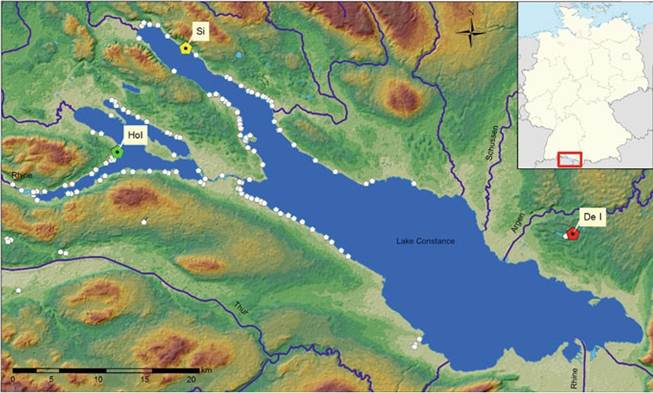
Fig. 9.1 Prehistoric pile dwellings around Lake Constance (not complete). The sites Ho I, Si and De I in green, yellow and red are discussed in the text (after Baum 2014, Fig. 1)
I mainly use GIS and ABM to integrate spatial, (paleo-) environmental and archaeological evidence with different competing models of land use in the wetland sites. The resulting scenarios are located in a hypothetical setting in order to underline the model character of WELASSIMO. To this aim, I chose a real landscape where no archaeological evidence is known, reconstructed a hypothetical natural environment integrating modern and paleo-environmental data, and simulated land-use activities in it as they have been reconstructed for the sites highlighted in Fig. 9.1, that were occupied in the early 4th Millennium BC. Thus it is possible to investigate the different pathways of landscape development and the systemic implications of certain hypotheses. The demand in non-finite resources such as livestock pasture, crop fields or suitable timber and their spatially and temporally varying availability can be assessed. In a second step, these hypothetical scenarios may be applied to specific archaeological sites integrating the local conditions, contributing to the understanding of the evolution of the earliest sedentary societies in this region.
9.2
More on the topic Introduction:
- 1 Introduction
- Introduction
- Introduction
- 19 Introduction
- Introduction
- Introduction
- INTRODUCTION
- Introduction
- Introduction
- Introduction