15 Living on the Edge
I
A history of the oceans might be expected to say little about the Atlantic before Columbus, or at least before the Portuguese discovered and settled islands out of sight of land in the fifteenth century, apart from a glancing reference to Vikings who reached America after they were lost off the coast of Greenland.
‘Atlantic history’ has become an entire industry, and it is mainly concerned with connections after 1492 between the four continents that border the Atlantic Ocean: North America, South America, Africa and Europe.1 At first sight there is nothing in prehistoric and ancient times to compare with the astonishing feats of the Polynesian navigators, nor with the mastering of the monsoons by those who crossed the open Indian Ocean. There are plenty of crackpot theories about ancient Egyptians or Phoenicians who reached Central America, and the name of Thor Heyerdahl comes up once again here. And yet, going back as far as the fifth millennium bc along the European flank of the Atlantic, and, quite separately, as far back as 2000 bc in the Caribbean, people moved across parts of the ocean, and the sea exercised massive influence on their social and economic life (the Caribbean will be described within a later chapter). Reconstructing these worlds depends on archaeology, but not just in one place - it is only possible to make sense of what was happening by looking at the links between societies separated by considerable distances, whether in the form of trade connections or similarities in culture, including art and architecture. For several archaeologists have identified a common north-eastern Atlantic culture that was formed by the communities living along the edges of the Neolithic Atlantic, from Orkney in the far north past Ireland and Great Britain to Brittany, northern Spain, Portugal and even the Atlantic coast of Morocco, a distance of about 4,000 kilometres. A spur leads down the English Channel to Holland, Denmark and Sweden, bringing parts of the Baltic into this Atlantic world, the world of what have been called ‘the Western Seaways’.2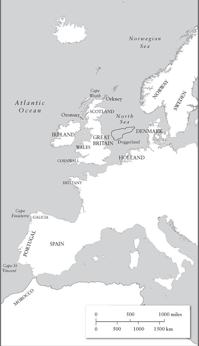
Still, there are several ways of interpreting the clear evidence that people built similar monuments in Portugal to those that were built in Scotland and Ireland. Traditional ‘diffusionist’ interpretations have gone out of fashion among archaeologists, and there is much more emphasis among ‘processual’ archaeologists on the internal dynamics of society, so it might be argued that similar physical conditions created similar solutions: pressed between the rough seas of the Atlantic and rugged shores, the inhabitants of Galicia, Brittany and northern Scotland found the same solution to the problem of how to subsist. And when connections can be demonstrated between communities hundreds or even thousands of kilometres apart, was this the result of direct contact, or did artefacts and ideas seep slowly from one area to another and another and another, in slow stages? Then there is the problem of how contact might have been maintained, either locally between shore-side settlements or over longer distances. Evidently sturdy boats were needed in order to reach Britain and Ireland from Brittany, and there are good reasons to assume that contact between Brittany and Galicia tended to be by sea. Land routes cannot be ruled out; but the coastal communities that are going to be examined here were not easily accessible by land: Galicia, with its deep fjord-like rias and its steep slopes, as well as a similar environment in Brittany or Wales. Even Cornwall was not as easily accessible as south-eastern Britain, because its hilly landscape was cut off from the rest of Britain by quite forbidding moorland.
According to this view, travel across water proved more rapid, while it was also possible to transport large quantities of goods between one place and another with much less physical effort than on land. The sea had its terrors; but as it came to be better known, and as astronomical knowledge increased, even the unpredictable waters of the eastern Atlantic were found to be manageable.3 Yet engagement with the ocean varied over time. Dependence on seafood might be replaced by reliance on pasture, agriculture and hunting. Trade connections familiar from the New Stone Age and the Bronze Age might wither in the Iron Age. This is not a history of ever-closer integration binding together this great arc of coastline, but a history of connections created, sundered and re-created over many millennia.In order to understand the nature of the space that will be described here, it is important to turn aside from a continent-based mental image of ancient Europe, and to visualize long stretches of coast punctuated by massive projecting promontories.4 Working up from the south, these include Cape St Vincent in southern Portugal, Cape Finisterre in Galicia, Brittany, Cornwall, and Cape Wrath at the northern tip of Scotland, an area also characterized by a profusion of rocky islands and easy access to the granite that has ever after been the chosen building material of many Scots. Strong winds from the ocean brought heavy rainfall, which favoured those trying to produce crops in low-lying corridors along the shoreline. When metalworking became widespread in the Bronze and Iron Ages, the ready availability of good-quality ores, including Welsh copper and gold, Cornish tin, and Iberian silver, tin and copper stimulated the creation of trade networks linking these lands and bringing in other lands, such as western Scotland, that were rather poor in metals but sought to acquire them.5
Describing the resources only goes so far; finding out who the people were who exploited them, and whether they were of common ancestry or culture, is also important.
Here even the most sober accounts of what has been found in the soil become entangled with the idea that the inhabitants of this Atlantic arc were ‘Celts’, whose ancestors had originated somewhere in central Europe and had migrated stage by stage until they could reach no further. The fact that classical writers used this term to describe peoples living in large areas of western Europe does not mean that ‘Celt’ is a precise ethnic label. As for the debatable question of what language they spoke, that will be addressed in a later chapter.6 Nor, indeed, is there much agreement about the role of the sea in drawing together prehistoric303 communities that were largely self-sufficient. Some communities, even close to the sea, depended on food they foraged from the land for their survival; but often their self-sufficiency extended to the sea itself, which was a magnificent source of food, some harvested along its shores, including the molluscs whose shells were dumped in vast, mountainous middens that altered the seaside landscape, while fishermen also used nets and hooks to catch large fish that swarmed in coastal waters. This is, then, a rather different story to the great maritime adventures of those who struck out across the open sea in the Pacific and, eventually, the Indian Ocean. It begins as a series of histories of local connections.
II
The effects of falling and rising sea levels have been felt much more dramatically in the Atlantic than in the Pacific or the Indian Ocean, and have had a powerful influence on how the edges of Europe were settled in Palaeolithic and Mesolithic times (the Old and Middle Stone Ages). About 11,500 years ago significant changes occurred, which geologists mark as the start of the Holocene period that has continued ever since; ‘Holocene’ means ‘wholly new’, and yet the Holocene is understood as a temporary warm phase in the middle of a continuing Ice Age that (in theory) should some day return; temperatures were not consistent, and fell by about 2oC early in the first millennium bc, at the end of what is regarded as the Atlantic Bronze Age.
These higher temperatures did not exactly make the climate in places such as Orkney balmy, but they did facilitate crop production and hence the growth of population.7 The changes that were taking place were geological as well as climatic. Long before the Holocene, the massive accumulation of ice far beyond the poles had sucked away water from the oceans and had lowered sea levels by thirty-five metres or more, exposing the floor of what are now shallow seas such as the North Sea. The Baltic began as a freshwater lake and was only joined to the salt sea as water inundated the land bridge between what is now Denmark and Sweden; the North Sea was partly blocked by the large expanse of Doggerland that linked the east of Britain to the continent before it sank beneath the waves to become what is now known as the Dogger Bank. The end of the Ice Age saw seawater levels rise as melted ice returned to the sea, and also made the climate more congenial for the limited number of humans who inhabited Europe around 8000 bc; Doggerland was one of the areas where they flourished.8 The process was more complicated than that, however, since the sheer weight of the ice had pushed the land304 THE YOUNG OCEAN: THE ATLANTIC, 22,000 BC-AD I500 hundreds of metres lower in some areas, such as Scotland, and as the weight was removed the land itself began to rise; Great Britain is still slowly tilting, with the result that the coast of East Anglia is gradually falling into the sea.9 Several islands around the British coast that were now clear of ice found themselves joined to the mainland for several centuries; it is possible that one could walk from Scotland to Orkney for a while, or at least wade across the tidal waters.10 In other parts of Atlantic Europe, the glaciers had scored deep gashes in the landscape, which remain in southern Norway and along the deeply indented western coast of Galicia in north-western Spain, creating the dramatic scenery of the Rias Baixas; their appearance was accentuated by the Atlantic winds and waves that stripped away softer stones and left behind the hard rocks of the Galician coastline.
This area will be revisited shortly, since Galicia has provided rich evidence for prehistoric communities that exploited the sea and enjoyed ties to other parts of the Atlantic shoreline.For the human population of Europe, the Ice Age had also been an era of extinction and repopulation. By 8000 bc, the Neanderthals of the Upper Palaeolithic, who had found a way to survive in the cold of Ice Age Europe, were long extinct.11 In the early Holocene period the modern human population remained very thinly spread around Europe, but some families were beginning to reach the Atlantic seashore, beyond the current coastline of France, Britain, Holland, Germany and Denmark. The cultures that were emerging in these lands are broadly described as ‘Mesolithic’, or Middle Stone Age, yet this is a troublesome term. It indicates that these people retained many characteristics of the Palaeolithic lifestyle, notably their reliance on hunting and gathering food, including, along the coast, seafood. The term ‘Mesolithic’ recognizes some innovations in toolmaking, for much of what is known about these societies depends on the close examination of stone tools that were becoming smaller, even very small (microliths); blades, harpoons, arrowheads and scrapers became everyday objects in the toolkit of Mesolithic hunters. These changes took many centuries, yet they occurred more or less in sequence across one area after another of western Europe, which shows that technical knowhow was spread by contact between groups of hunters. This improvement in the quality of tools in turn indicates that the tasks being performed in Mesolithic societies were becoming more complex, such as sewing together animal skins to make more effective clothing, and, using the microliths, the creation of delicate secondary tools made of wood, reed and bone. In some areas, simple pottery was created. It is a moot point whether Atlantic Europe learned from or developed independently techniques that can be observed in the Middle East in the twelfth
305 millennium bc. In the Middle East the Mesolithic inhabitants gradually developed an interest in farming, by taming the wild grasses they had been gathering since time immemorial; large villages and even fortified towns became home to more and more of those who lived off the soil. But along the Atlantic coast of Iberia around 5000 bc the relationship with the soil was different; grass seeds formed part of quite a rich diet, but were still casually gathered as they grew wild in fields and meadows, alongside berries, bulbs (notably onions) and legumes.12
Each environment was different in detail, and each small pocket of population exploited what was to be had without having the need to develop close interaction with neighbours, or at any rate trade in foodstuffs - no doubt other forms of interaction, such as the exchange of brides or warfare to gain control of valleys rich in game, were quite frequent. During the Mesolithic period, populations became more settled, and villages began to emerge; the inhabitants would mark out the territory they exploited, though it is unlikely they thought of this as rule over a chunk of land. They sought control of the material assets of the land, not the land itself. A harsh winter or a boiling summer could suddenly deplete resources to dangerous levels as the seasons changed. From this point of view, living by seas and river mouths was a sensible strategy; what mattered was variety, rather than reliance on a staple foodstuff. The more diverse the habitat, the easier it was to survive, and that made the coastal fringes of Europe the most attractive places to settle. In addition, it was as far as one could go by land. By the fifth millennium bc these areas hard by the shore were therefore quite densely settled, and as the population rose pressure was placed on the food supply, which, again, fostered movement - the voluntary or forced departure of superfluous people for new lands. With time, migrants needed to search further afield for empty spaces, whether by trekking along the coast or by braving the sea in boats made from animal skins, wicker or felled trees - since the evidence for boats comes from the Bronze Age, the design of their boats will be looked at later.13
Unfortunately, much of the best information about these shore-dwellers is now buried beneath the sea, for the shoreline that they knew has been inundated, and the remains of what appear to be coastal communities often come from settlements a little way inland. But this is not always the case, since the melting of the ice also allowed landmasses in some areas to rise. For that reason a good many archaeological sites from this period survive in northern Scotland, including middens, mounds of food debris. Oronsay, to the south of Mull, is a tiny island off western Scotland that already stood offshore in the Mesolithic period; archaeologists have been able to deduce the exact time of the year at which the type of pollock
306 THE YOUNG OCEAN: THE ATLANTIC, 22,000 BC-AD I500 known as the saithe was caught, because its ear-bone grows longer according to a strict schedule. This shows that people moved around from midden to midden; these people were either inhabitants of the island itself, who over the centuries gobbled down gargantuan amounts of fish and shellfish, or, bearing in mind the minute size of the territory, they came across from bigger islands nearby (Islay, Jura, and so on) on seasonal visits, because they knew that its intertidal outcrops were a perfect breeding ground for shellfish.14
Brittany too is a rich source of information, with plenty of middens containing the remains of seafood that indicate how, by 5000 bc, the inhabitants had become heavily pescatarian in taste. The fact that they neatly deposited the shells in reserved piles indicates that they did not simply comb the beach for throw-away snacks, but brought their catch to places where their family could enjoy what they had found. They took up residence on little islands off the coast such as Hoedic, where there was not much hunting, apart from netting birds or shooting at them, but plenty of food from the sea, and the right sort of rocks from which they could knap their tools. These early Bretons ate a great variety of shellfish: periwinkles, limpets, cockles, mussels, as well as many types of crab. They exploited the Atlantic tides to cross the sands and collect the rich harvest of the sea. Consumption of seaweeds such as samphire and of plants that grow close by the seashore such as sea kale made the seaside a very attractive place to live.15
In several parts of Atlantic Europe milder temperatures caused a spurt in the growth of forests, and the opportunities for hunting declined as wild animals such as deer were crowded out of their habitat by the trees. This prompted people to move in ever greater numbers towards the coast, away from impenetrable lands in the interior. In Denmark, at a place now known as Ertebolle, the late Mesolithic inhabitants hunted any animals they could find, even including lynx, wolves and pine marten. But they loved fish - herring, cod and flounder were favourites - and they also exploited freshwater supplies, taking eels and pike from rivers and lakes. They took seals from the sea and ate them too. They paddled around in log-boats, which were sometimes at least ten metres long, and they built fish traps out of wickerwork; organic objects of this sort have survived in the marshy conditions of Denmark, to be unearthed by Professor Glob (of Dilmun fame) and his colleagues. And then there were the piles and piles of oysters, cockles, mussels and periwinkles. It was, after all, much less work to go beachcombing than to rely on catching deer, elk and aurochs, which might escape the hunter for days at a time, a change ‘away from the high-risk, high-yield, high-energy expenditure strategy of game
307 hunting to a low-risk, moderate-yield, low-energy expenditure strategy’, in the concise words of Barry Cunliffe.16 One could go further: the dependence of these folk on the produce of the sea must have affected their system of values, which would place less emphasis on the martial skills associated with hunting (casting spears, shooting arrows, and so on) and more on the nautical skills needed to master even inshore waters.
III
By the fifth millennium, as new technology began to spread in Europe and many other parts of the world, with the gradual domestication of animals and the adoption of farming, not merely the diet changed. Although the term has come into and gone out of fashion, this is often described as the age of the ‘Neolithic Revolution’; it turns out to have been a very slow revolution, and it is increasingly obvious that many of its apparent innovations reached back into the l ate Mesolithic period, particularly in the Middle East. Farming the soil, if not the herding of animals, encouraged settlement in permanent villages; this was often the case even when the early farmers followed the widespread practice of slash-and-burn cultivation, which involved the clearance of forest, the planting of the soil, and the cultivation of another patch of cleared forest after the original piece of land had been exhausted of nutrients. The new grain-based diet was not necessarily healthier: body sizes appear to have shrunk from an average of 1.7 metres for men and 1.57 metres for women in the Upper Palaeolithic period to 1.67 and 1.54 in the Neolithic age. This may not seem a significant amount, but skeletal remains also reveal a decline in dental health and an increase in diseases associated with malnutrition, especially among children - infant mortality was high, life expectancy was low.17 As tasks within society became more specialized, political elites emerged who organized production and defended the community’s territory. A distinguished archaeologist has spoken of ‘population stress’ along the Atlantic seaboard within the period from about 4800 bc to about 2300 bc.18
This leaves the important but controversial question of where the Neolithic peoples of the Atlantic coast, and of western Europe in general, came from, assuming they came from anywhere and were not just the descendants of the old Mesolithic inhabitants who had learned new skills as these skills filtered from one community to another and, higgledy-piggledy, were copied by the existing population. The easiest way out of this dilemma, but also without doubt the most accurate answer, is that both answers are
correct in different measure and in different places at different times.19 One could hardly expect all the communities that had developed along the coastline from Iberia to Scotland by the late Mesolithic age, say 8000 bc, to have responded in an identical way to the arrival of farming, for each of these communities exploited different resources in the sea, in the rivers and along the edges of the forests. One case, at first sight surprising but in fact only to be expected, is the shift in diet that took place in Brittany as the Mesolithic faded into the Neolithic around 4000 bc. The people of Hoedic, which has been mentioned earlier, lost much of their interest in seafood and seabirds, which would have left a strong signature in their skeletons, and became fashionably Neolithic in their preference for grain, dairy products, meat and other non-marine products. It is possible that these areas had been taken over by migrants from the interior, which would explain their lack of interest in the sea.20
Even if these early Bretons were less interested in the harvests of the sea, they may still have been keen to cross the sea, either to settle other lands or to acquire objects they could not obtain or produce locally. The great triangle of Brittany, standing in the way of direct passage by sea from south-western France to the English Channel, looked in several directions. In the sixth to fourth millennia bc sea contact along this coast becomes visible to archaeologists, who would not exclude the strong probability that this is the second or third chapter in a story of maritime connections that began in the Middle Stone Age, or even in the late Palaeolithic. A marvellous example of Breton links across the sea is provided by a small passage tomb in Scotland from around 4000 bc; these passage tombs, entered by a corridor and lined with stone, are characteristic of the ‘megalithic’ culture that will be discussed shortly. It is located at Achnacreebeag, on the west coast not far from Oban. Its most remarkable feature is that it contained pottery at a time when the art of pottery was unknown in Scotland. The pots found in the tomb are from Brittany and Lower Normandy, and they were carried at some point across the open sea, most probably up the Irish Sea directly to western Scotland, since a few fragments of similar pottery have turned up in north-eastern Ireland. Among the scenarios that archaeologists then envisage is the movement of a small group of Bretons around 4000 bc, just when tombs of this type were becoming fashionable in Brittany.21 Some of these Bretons reached as far as Scotland, others, whether at the same time or earlier and later, made their landfall in Ireland, passing also through Cornwall, Wales and the Isle of Man, all of which were inhabited by people using similar ‘Tardenoisian’ flint tools as early as the Mesolithic period.22
Meanwhile, objects from Iberia turned up in Brittany and were buried alongside its inhabitants.23 While they may have filtered up the coast of France overland, it is clear that early Neolithic travellers possessed the knowhow to cross tracts of the Atlantic Ocean: if Bretons could reach Scotland by sea, they could reach Spain. And Spain stands at the centre of a bigger argument about Neolithic culture, the debate about the megaliths.24 The origins of the large stone structures found along the coast of Spain and Portugal, as well as inland, and in great numbers in Brittany, not to mention northern France and parts of Britain, have long been debated. They are best described as large stone structures rather than structures made of large stones, as not all the stones used were mega, or ‘large’.25 The most famous of these structures, Stonehenge, is far from the sea; however, even setting aside the more bizarre arguments about its use as a Neolithic computer, this and other Neolithic structures reveal a knowledge of the heavens that was surely exploited by sailors as well as the priests and rulers of Late Stone Age southern England.
Most of the structures are classed as graves, though whether they really were that, or just that, is a complex issue. The traditional assumption has been that two distinctive types of tomb appeared over large areas of Atlantic Europe during the Neolithic period: the passage grave, which consisted of a corridor leading into an often circular inner chamber, all carefully constructed out of large blocks of stone; and the gallery grave, which lacked the inner chamber but was once again built of stone and often covered over with earth. Elaborate theories were built on the argument that they represented different cultural streams. Modern dating using Carbon 14 and other methods established that the earliest passage graves so far identified are to be found in Brittany, and go back to the fifth millennium bc. On the other hand, a series of passage graves from southern Spain were built about a millennium later.26 This style of funerary architecture was not a passing fancy; passage graves were constructed in northern Scotland, in northern, central and south-eastern Ireland, in Brittany and along the coast south from there; and all around the Iberian coast from Galicia to southern Spain; but they also appeared in Denmark and northern Germany, with 7,000 identified in Denmark alone, maybe one third of the number in existence 4,500 years ago.27 They range in date from 4800 bc to 2300 bc, and none can be found more than 300 kilometres from the Atlantic or North Sea coasts.28 But they did not all develop at the same time, and they originated in different places in different ways - in Great Britain the custom around 4000 bc was to build unchambered long barrows, still a feature of the British landscape; and these developed into passage graves later. Meanwhile the Bretons constructed grander graves ahead of everyone else. To say that knowledge of these Breton monuments influenced the architecture of passage graves in England or Iberia is not the same thing as claiming that the same people, of the same ancestry and language, built all these monuments. There is general agreement that different places developed this style of monument independently, with Brittany coming first, and once the megaliths were a common feature of the landscape along the shores of western Europe, different communities copied details of the design and structure from one another, to make their own monuments more perfect.29
When speaking of perfection, the megalithic settlement at Skara Brae in Orkney has a special claim to attention. This is not just because it, and above all the passage grave at Maes Howe, is very well preserved; it also sits in the midst of other important Neolithic sites from the period 36002100 bc. The first Neolithic settlers on Orkney (assuming they were not descended from Mesolithic predecessors) arrived from the facing shore of Scotland around 3600 bc with their animals - cattle, sheep and deer - and took advantage of the excellent fishing to be had around the islands.30 There were very many deer on the Orkney island of Westray, and it is possible they were herded rather than allowed to run completely wild. Catching birds and collecting birds’ eggs was another way of ensuring a high-protein diet. The consumption of shellfish, as elsewhere along the Atlantic coast of Europe, was prodigious. The predominance of limpet shells can be interpreted in several ways. Since this is a low-nutrition shellfish, reliance on limpets could indicate that during periods of shortage or famine the islanders relied on this second-class food. Or they may have been used as fish bait, a practice that has not disappeared from the area. The fish the islanders caught was probably used not just for human consumption but to produce fish meal, of the sort already encountered in the Indian Ocean; and this would be fed to animals.31
This style of life was very stable and lasted for maybe half a millennium. The islanders’ use of stone slabs, easily obtained, to construct their houses means that there are some truly remarkable archaeological sites on Orkney, which offer a very clear idea of how their occupants lived; for once, it is possible to move beyond evidence about how people disposed of the dead and to gain an intimate idea of how they lived from day to day. Half a dozen or more stone houses, sunk a little into the earth, were constructed at Skara Brae on the main island, and fitted out with stone cupboards and shelving, most likely box beds, benches and hearths, and even what has been described as a dresser, which may have served as a display cabinet, one of whose functions was to impress visitors. Storage boxes were let into the floor - one contained beads, pendants, pins and a dish containing red pigment made out of one of the vertebrae of a whale. These houses formed a compact group, linked by semi-subterranean passages.32 Another structure at Skara Brae was evidently a workshop, where flints were knapped using sophisticated techniques that involved the heating of the chert out of which stone tools were manufactured.33
The inhabitants of the Orkney archipelago lived in small communities scattered across the islands, and apparently obtained enough food and raw materials to meet their needs. Many mysteries about their social and religious life remain. One puzzle is why their chambered tombs so often contain vast amounts of human bone from disarticulated skeletons, but many bones are missing: at Isbister there were many foot bones but few hand bones, and plenty of skulls. Bodies were allowed to decompose and then the bones were collected and redistributed. This suggests the existence of elaborate rituals in which bones were rearranged - perhaps a moderately efficient sorting process so that individual chamber tombs specialized in particular parts of the body. This surely demonstrates that the tombs were not places for the long-term burial of individuals but were seen rather as part of a single greater funerary monument that stretched across an entire island and in some sense embodied the spirit of the island.
The houses at Skara Brae are remarkable enough, but the chamber tomb at Maes Howe has been described as ‘one of the supreme achievements of Neolithic Europe’. It even left a bizarre impression on the Vikings, who covered the walls with runic inscriptions thousands of years later, and mentioned it in the Orkneyinga Saga : ‘during a snowstorm Earl Harald and his men took shelter in Maes Howe and there two of them went insane’.34 The quality of the craftsmanship was exceptional: stones were neatly fitted together and were carefully dressed to create flat surfaces in the low corridor leading to the core of the monument, as also in the central ‘hall’, even though some of the stones used to line the walls weighed as much as three tons.35 The islanders were learned in astronomy, and carefully aligned the monument at Maes Howe with the solstices, indicating that sun and moon rituals were conducted here. This was not unusual - one of the greatest megalithic monuments, New Grange in Ireland, was similarly aligned, and the decoration on its stones matches that at Maes Howe, so connections between Orkney and Ireland must have been close, with regular visits to Ireland by Orcadians.36 The Orkney archipelago provides inherent evidence for the use of the sea passages by Neolithic navigators: they crossed the sea to arrive there in the first place, and all the evidence suggests that they prospered, despite living on what is not the most welcoming climate in Britain. More than that, Orkney, when compared with Ireland and elsewhere, provides evidence for cultural contact between communities separated by the sea - not just art but ritual was shared between communities. The communities on these islands were reasonably self-sufficient, but they did not become cut off from the outside world.
Away from Orkney we depend on the evidence from tombs, or structures that at first sight appear to be tombs. That gallery and passage graves became a widespread fashion is not in doubt, but what caused this change in burial practices is far from clear. Archaeologists were tempted to compare evidence from the eastern Mediterranean (some of it actually much later, but dating methods have taken time to improve); they then concluded that the practice spread from the east by way of Malta, Sardinia and the Balearic Islands, each of which has its own impressive stone monuments. It was also tempting to link this to the cult of the Mother Goddess or Earth Mother who may well have been worshipped in the great stone temples of Malta around 4000 bc.37 Admittedly, the great stone towers, or nuraghi, of Sardinia are much later, and a subtle distinction has resulted in the classification of the talayot, or prehistoric stone monuments, of Minorca and its neighbours as ‘cyclopean’ rather than ‘megalithic’; but it was easy to draw lines on a map showing how the megalithic culture of the Atlantic was diffused out of the Mediterranean towards Iberia, and then out of Iberia towards Brittany and the British Isles. British experts expressed polite differences of opinion with Spanish archaeologists, who, with a nationalist flourish, were determined to show that Galicia and northern Portugal were the obvious places to find the origins of the megalithic culture of Neolithic western Europe. However, the dates of the Spanish tombs were relatively l ate - the end of the fourth millennium bc for the very earliest. To be sure, the grave goods found in southern Spanish megalithic monuments show both Atlantic and Mediterranean influences; this was a place where the Atlantic and the Mediterranean worlds converged.38
In the end, though, the old ‘diffusionist’ approach to Megalithic culture, arguing that it was spread by migrants from the Mediterranean, was abandoned even by its former champions such as Glyn Daniel, the Cambridge archaeologist who also did much to promote archaeology in the early days of television.39 Carbon 14 dating produced surprises and pushed the date of these monuments much further back in time, so it made no sense to see them as massively reduced imitations of the pyramids, not that it had ever made much sense to do so. Yet these differences of opinion converged at one point: the megalithic tombs were characteristic of the lands along the Atlantic seaboard. Moreover, they do share some features. Plaques inscribed with designs that seem to show boats, axes, snakes and undulating lines are found in several areas, so that similar snake designs were used in Galicia, Brittany and the Irish Channel, and there are
313 similarities between snake patterns found carved on slabs in passage graves from Anglesey and patterns used by megalithic builders in Galicia, who were versatile builders, using carvings and paintings in their structures.40 Rather than showing that the megalithic tradition spread slowly out of the Mediterranean and into first southern and then northern Spain, all this suggests that there was a good amount of to-i ng and fro-i ng between Iberia, Brittany and Britain, so that the north-west corner of Spain, the north-west corner of France and the Irish Sea were linked by regular sea voyages. Brittany stood at the centre of this Atlantic world, and was more precocious in its use of this architecture than its maritime neighbours to north and south.
Were these monuments actually tombs? In some, no human remains have been found. But even when there is evidence of burial this does not mean the prime purpose of the megalithic mounds was to dispose of the dead with honour. They may also, or primarily, have been used to mark out territory at a time when a more settled Neolithic population was beginning to think of ownership of the land itself and not just (as in the Mesolithic era) the exploitation of its resources. This makes good sense because the coming of farming tied humans to the land in a way that did not apply to a hunter-gatherer society. These were small, localized societies, for there is no evidence of great power centres nor of large settlements similar to the towns that had emerged in the Middle East during the early Neolithic period. In such a fragmented society, subject to constant pressure as agriculture and pastoralism brought population increase, it was important to know who belonged where. Monuments to, and often containing the remains of, the ancestors of the leaders of the community acquired special importance. For this reason it made sense to raise large mounds over the chambers these people carefully constructed. Whether they stood at the edge of a territory, to mark out borders, or at the centre, to function as cult centres and hallowed places where the leaders of the community would announce important decisions, they were places for the living as well as for the dead. When no evidence can be found that they were used for burial, the likelihood still remains that they were built to commemorate ancestors, sometimes so distant in time that there were no bones to show for them; or sometimes the mounds may commemorate people lost at sea whose remains were simply not available for burial. Quite often, indeed, the corridor was left open so people could come and go into the inner chamber.41 For us, they also open a door - one into the political world of these early Atlantic societies.