The Early Modern Search for Geographic Knowledge
The early modern search for geographic knowledge was fueled by economic competition between commercial centers. As Mediterranean countries learned more about the lucrative spice trade and existing merchant networks in Asia, they wanted to tap into the commercial opportunities they offered.
From the Italian city-states the desire for geographical knowledge and more accurate mapping technology spread to Portugal, Spain, and the Ottoman Empire, each of which was eager for a share of the international spice trade. Yet, other conditions also had to be right. All learning stems from the combination of mastering a foundation of existing knowledge, openness to new ideas—often from outside—and innovation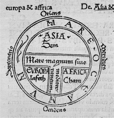
Figure 8.1. T and O map, 1472. From Isidori lunioris, Epistola. Source: The Newberry Library.
based on observations, new insights, and experimentation. These conditions would be met when over the course of the twelfth through fifteenth centuries, a number of developments occurred that would form the foundation for fundamental shifts in geographical knowledge and cartographic representation in the Mediterranean basin.
Roger II of Sicily (1095-1154), a Norman king descended from the conquest, fostered an environment at his court that combined the best that the Norman, Mediterranean, and Islamic worlds had to offer. At his court, a twelfth-century Muslim scholar by the name of Al-Idrisi composed what has been described as “a vast geographic panorama of the entire habitable world... accompanied by detailed maps founded on Ptolemy’s works, the geographic tradition of Baghdad and new information provided by merchants and voyagers.”23 The innovative ideas he shared led to a new way of visualizing the world that would come to challenge, and eventually replace, the conceptions prevalent in medieval Europe’s “T and O” maps (see Figure 8.1).
At roughly the same time, portolan charts (Figure 8.2) gradually came into use. Navigational maps based on compass bearings that emphasize coastal shapes and place names, the origins of portolani remain obscure, but the earliest extant examples center on the Mediterranean world. Portolan charts allowed sailors, who had once relied primarily on familiar-looking coastal configurations to keep their
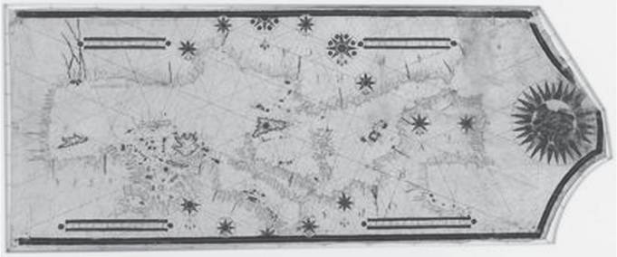
Figure 8.2. Portolan Chart, ca. 1550.
Source: Library of Congress. https://www.loc.gov/item/2010588182/
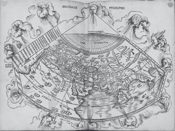
Figure 8.3. Ptolemy, “Map of the World,” 1513 edition.
Source: Library of Congress. https://www.loc.gov/resource/g3200m.gct00262/?sp=77
bearings, to venture further from the shores into open seas. Over the course of several centuries the area they charted would gradually grow to include both the Atlantic and the Indian Oceans and their coastal areas.
Finally, the (re-)introduction of the Greek geographer Ptolemy's work into the Mediterranean world changed the way that space was conceptualized (see Figure 8.3). In 1409 a Greek-language manuscript that had been held in Constantinople (now
Istanbul) was translated into Latin, introducing notions of latitude and longitude to select readers in the Mediterranean world. The work was also translated into Ottoman in 1465. After initially circulating only in manuscript form, its 1477 publication allowed broader circulation of the conceptualization of the earth as a sphere onto which specific locations could be pinpointed according to coordinate points. This global grid made it conceptually possible for the Vatican to “draw a line” that would distinguish separate jurisdictions for Spanish and Portuguese exploration and conversion overseas with the Treaty of Tordesillas in 1494.
Ptolemy's vision, as adopted in Abraham Ortelius's Theatrum Orbis Terrarum in 1570, encouraged a conceptualization of every part of the world, no matter how remote, as connected with every other.
Although the coordinate system would not be a reliable means of maritime navigation until the invention of the marine chronometer by John Harrison in the eighteenth century, cosmographers started to incorporate it into even marine maps before that time. However, chorographic, or regional, maps not linked into the global network continued to be significant in the form of cadastral maps, cityscapes, and maps of individual kingdoms for some time. The maps in the Palazzo Vecchio in Florence and the Vatican's Gallery of Maps, commissioned in 1580, are just two examples of the way in which political entities increasingly used maps to project their own power through a variety of types of representation of territorial knowledge and control.The still prevalent portolans were, however, neither strictly scaled, nor part of the coordinate system of mapping based on latitude and longitude. As the importance of geographic knowledge moved west into Portugal and Spain, these powers set up institutions that would attempt to advance and to standardize mapmaking and to control the dissemination of geographical knowledge. The Casa de Contratacion was established in 1503 in Seville, Spain, and its counterpart, the Casa da India, from the merger of several existing trading organizations in 1504 in Lisbon, Portugal. These institutions, which regulated imports, also worked with navigators and a variety of field agents to obtain geographical information in order to generate and subsequently continually update master maps based on a coordinate grid. This master plan was designed to assure the accumulation of the latest knowledge for the crown, which also did its best to preserve a monopoly over that knowledge. Not everyone recognized the importance of the project or was eager to comply. Tensions between sea captains and cosmographers paralleled those between individual entrepreneurs and the state. As geographic information was consistently leaked to other countries, Spain and Portugal's quests for control of geographic knowledge ultimately had to be given up as a lost cause, and the master pattern maps fell into disuse by circa 1560.24 Other countries would eclipse their geographic efforts, with France becoming a major player under Louis XIV, Russia expanding its cartographic capacities during the mid-eighteenth century, and Britain coming into its own in the second half of the same century.
European empires were not the only ones actively working to expand their base of geographic knowledge during the early modern period.
The Ottoman Empire fostered its own mapmaking centers and kept pace with recent discoveries, spurred on by competition from Portugal. As Giancarlo Casale has described it, “Ottomans and Europeans were part of a larger interactive process, in which each side formulated ambitious plans for global expansion that followed the same underlying logic, even as the particulars of their respective imperial projects diverged in important ways.”[618] As was true also for Europe, the Indian Ocean was already known to the Ottomans before the early modern period but became an object of greater interest during the fifteenth and sixteenth centuries.Sultan Mehmed (d. 1481) was a great patron of geographic knowledge. He commissioned a translation of Ptolemy's Geographia in 1465, and also collected Italian reproductions of the work. His grandson Selim I (r. 1512-1520) continued the pursuit of geographical knowledge through both engagement with Europe and sponsorship of original Ottoman works. These included a 1516 Book of Cathay documenting a voyage from Iran to China, and a travel narrative of southern Europe dating from the same year. Most famous, however, was a 1513 map by the navigator and cartographer Piri Reis. Based on Ptolemaic maps, Portuguese sea charts, a chart of India from Arabic sources, “an original sketch map of the Americas from Columbus's third voyage,” and an interview with a crew member of one of Columbus's voyages, it was unprecedented in world history in its scope and content. Extant portions of the map (Figure 8.4) show the Atlantic with recent discoveries in the New World, but its main focus centered on the Indian Ocean.[619] Piri Reis also authored a complete Book of Navigation, the Kitab I bahriyye, that was first completed in 1525.[620] A revised edition dating from the late seventeenth century is held by the Walters Art Museum.
One year after the appearance of Piri Reis's 1516 portolan, the Ottoman conquest of Egypt would be complete.
The seizure, not only of Egypt, but also of Syria and Arabia gave the Ottomans vast resources and leadership in the Muslim world.[621] It also provided the Ottoman Empire with access to the Indian Ocean unparalleled among Mediterranean states. As a result, the Ottoman Empire replaced the Mamluks as Portugal's primary competitor in the Indian Ocean. In subsequent years, Sultan Suleiman's vizier, Ibrahim Pasha, continued the pursuit of geographical knowledge and more accurate maps. Most notably he commissioned Piri Reis to undertake the Book of the Sea, which “[i]n its final form, as presented to the Sultan in 1526... constituted the single greatest masterpiece of Ottoman geography and cartography ever produced.”[622] Ibrahim Pasha also managed to obtain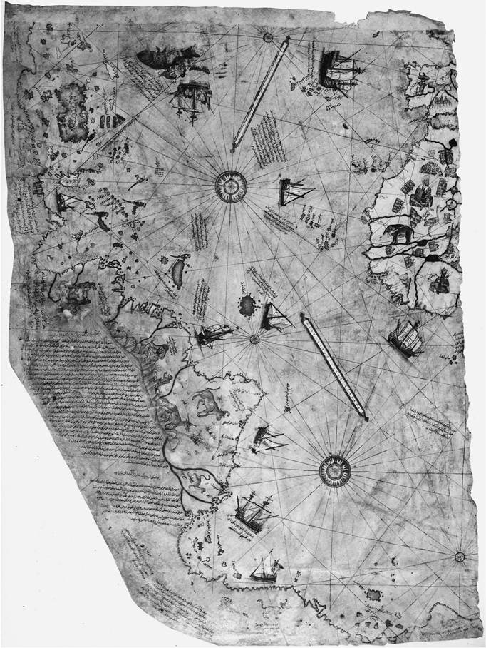
Figure 8.4. Piri Reis, Portolan.
Source: Topkapi Library.
Photo: Wikimedia Commons. https://commons.wikimedia.org/wiki/File:Piri_reis_world_map_01.jpg
from Portugal a chart of Magellan’s discoveries done by Pedro Reinel. Concerned as the Portuguese were with the confidentiality of their geographic discoveries, the transmission of the map to Istanbul, where it remains in the Topkapi Library, was a real coup, the details of which remain a mystery.30
The development of maps went hand in hand with the extension of Ottoman overseas commercial and territorial empire in Egypt and parts of the Indian Ocean. In geographical knowledge and in extending their empire, the Ottomans were competing with the Portuguese, and of course competition is only possible when playing the same game. Although the Ottoman court may also have experienced its own discussions and struggles over what constituted the most appropriate mapping techniques, it is instructive to recognize that in many ways similarities characterized the unfolding of early modern cartographic production in Portugal and the Ottoman Empire, including the fact that there was little uniformity within the mapping idioms of either empire during the early sixteenth century.
A variety of ways of seeing and conceptualizing territory easily coexisted within imperial centers at this time. Even though scaled maps were being created and closely guarded by imperial Spain to assist in navigation abroad, the visual images created for Charles V in explorer Hernan Cortes’s “Second Letter from Mexico,” drafted in 1520, take the form of a verbal map. Cortes used the letter as an opportunity to use words to create visual images of the lands into which he traveled for his king. As Ricardo Padron describes it, for the narrative thread to follow the route traveled, as did Marco Polo’s early travel narrative, was only natural. For his audience, discourse was “the primary means of figuring space.”[623] A pictorial or cartographic map was unnecessary.
The various types of pictorial and cartographic representations that Philip II (r. 1556-1598) commissioned of Spain in subsequent decades provide us with a good example of divergent but contemporaneous ways of experiencing and conceptualizing territory. Cityscapes painted by the Flemish artist Anton van den Wyngaerde depicted various cities of Spain, each with their own architectural particularities and other uniquely defining characteristics. The cityscapes are done from a perspective that the eye would have had if the viewer enjoyed a vantage point from a neighboring peak just above the region depicted. Each view, while comprising an important part of Spain, differed significantly from every other. The initial impetus for the cityscapes may have stemmed from the king’s desire to see, as well as to assert his authority over, an array of the famous sites of his realm. For, seeing and the ability to represent a scene on paper constitute a kind of ownership, just as familiarity with the particulars of a local landscape gives one a special connection to that place.[624] Yet, this type of particularity of place would soon be superseded by a preference for uniformity of scale and of iconography in the representation of space.
As his kingdom grew, it was no longer feasible for Philip II to travel to each of these locations, as his great-grandparents had done. Under the logic that prized particularity and direct experience, seeing and being seen still had reciprocal roles in the establishment of ties between rulers and ruled. Thus, when he could no longer travel the entire realm, Philip II not only commissioned landscape paintings for his own perusal, but also “gave as gifts copies of his portrait, so that his subjects and relatives would at least have an image” to gaze upon if they could not see him in person.[625] As technologies allowing surveillance from a distance emerged, familiarity with local particularities would become less important to the monarch, and a need for a bird's eye view of the realm, made legible through the use of uniform symbols, more desirable, thus undercutting the importance of local difference and particularity of place.
At roughly the same time these paintings were being done, Pedro de Esquivel was busy working on a different kind of atlas, one based on survey maps of the Iberian Peninsula, for the same Spanish monarch. The Escorial Atlas, which was completed after de Esquivel's death but to which his labors contributed, “contains by far the largest European maps of their day to be based on a detailed ground survey.”[626] The atlas maps took the principle of allowing territory to be surveyed (quite literally) from afar several steps further. Whereas the van den Wyngaerde's cityscapes had allowed for particularity in their representation of place, appealing no doubt to nobles who would have had strong local identifications due to the role of their families in the history of these localities, the atlas allowed for a diminishment of attention to local particularities and for Philip to synthesize the entire scope of his domains into a coherent whole.[627] In the atlas maps, particularity of place and history are exchanged for uniformity. The regions portrayed become part of history- in-the-making in the emerging power of Spain, rather than unique in their own right. In other words, the atlas emphasized Philip II's realms “as a continuous and politically undifferentiated geographic expanse”[628] while diminishing the visibility of its divergent and constituent parts and undercutting the power and position of local lords - just as still the many maps drawn for these volumes.
As Spain incorporated colonies abroad into its reach, this kind of envisioning from afar, especially without particularities of place and history—which were in any case more difficult to document and to understand from a distance—would become even more imperative. In 1579 Philip II decided to extend his cartographic gaze into the New World. He commissioned a project designed to map the territory and describe the peoples of New Spain. The Relaciones Geograficas, as the resulting reports were called, provide another example of a contest of legibilities, so to speak. Presided over by Juan Lopez de Velasco, as chronicler-cosmographer of the Indies, the hope was, with the help of Spanish colonists on the ground in the New World, to obtain accurate maps of the territory and detailed descriptions of its inhabitants in separate documents. The Spanish colonists, however, valuing pictorial and graphic images lightly in comparison to textual description, delegated the cartographic tasks to indigenous artists who mapped not lands so much as communities replete with histories and emblems of powerful local families and indigenous knowledge. Furthermore, the lines of demarcation between different genres to be produced were either disregarded or not understood. Ironically, the resulting maps were fully legible to almost no one. In Spain no one could read the Nahuatl script. The locals could not read the Spanish that was added to the maps before being sent to Spain, and the majority of the indigenous people could not read (or speak) Nahuatl, the language of their earlier Aztec conquerors, in which the maps were primarily written. This attempt at imperial mapping included so many voices that the result was something of a cacophony, fully comprehensible to almost no one. The documents, eventually returned to Spain, were deemed thoroughly unusable and the project dropped. Philip's attempt to impose uniform legibility on the colony was foiled by local interests and complicated by other points of view.
In the seventeenth century, under the expanding Romanov Empire, Russian mapping also reveals an interplay of local interests and centralizing power. Maps of localities were commissioned by the state, but based on the reports of local people. Often invoked in the resolution of land disputes, the iconography on these maps includes houses of worship, natural landmarks, and humble peasant dwellings. Valerie Kivelson finds that the maps empowered the humble people of the land. “Being bound to the land,” the serfs “could rightfully assert that the land was equally bound to them.”[629] The maps represent the interdependent relationship between the people and the centralizing authority of the state.
As the Romanov Empire began to extend its reach into Siberia, mapping was extended into these farther reaches of territory. Prior to the introduction of modern scaled mapping, initiated by and carried out during the reign of Peter the Great (d. 1725) and subsequent monarchs, these imperial maps display an iconography that embodies the Orthodox Church as bestowing legitimacy on the imperial project. Russian settlements were demarcated by the presence of a cross on top of a stile. The lush iconographic symbolism of green leafy trees “depicted the Muscovite countryside as... a distant echo of a lost Eden,... and a prefiguration of the paradise to come.”[630] The colonists' role then became to “advance Russian settlement and conquest to tip the scales and transform the land from vacant barrenness to fruitful bounty.”[631] The Tsar's sponsorship of orthodoxy in turn provided him with a blessing to transform the frontier.
In the iconography of early Romanov imperial expansion there was a place for the native inhabitants on the maps. Semon Remezov, for example, recorded the presence of “indigenous peoples, fixing their mobility and diversity in set locations with ethnographic markers.”[632] Instructions from the court to frontier administrators included a strict injunction to “[c] onvert no natives against their will.”[633] In the logic of the pre-modern Russian Empire, as in the neighboring Qing Empire, the presence of diverse groups of peoples within the empire redounded to its glory. Nor did their customs and beliefs need to be made uniform with those of the imperial power who was now to rule over them and the territories that they occupied. The later atlases of Ivan Kirilov (1734) and Joseph Nicolas Delisle (1745), would, however, wipe evidence of habitation off the land, representing strictly territory and significant landscape features, but not evidence of the inhabitants. Their habits and customs were recorded in separate ethnographic genres that arose at the same time.[634] Once again, map standardization would eventually prove the more useful tool for the unifying purposes of early modern empire.
In Ming-Qing China, the Romanov's neighbor to the south, we see an example of empire strong enough in both its indigenous mapping traditions and its patronage of early modern science—and wise enough in its cultivation of various strong internal constituencies—to sponsor a variety of styles of imperial mapping simultaneously for a period of several centuries. The Jesuit missionary Matteo Ricci introduced concepts of latitude and longitude into China in the late sixteenth century. The Ming court (1368-1644) propagated this knowledge through an imperially sponsored world map in Chinese made by Ricci and his Chinese colleague Li Zhizao, published in 1602. Just over a century later, under the Qing (1644-1911), we see court sponsorship of scaled mapping projects of the entire empire under the Kangxi emperor, undertaken with significant Jesuit participation (Figure 8.5).[635] The resulting surveys were completed before those of France or Russia, and circulated to important centers in Europe. Through their publication abroad, a cartographic image of China, Chinese Tartary (Manchuria), and Tibet was formed and fixed in the eyes of Europe. These maps were also revised and updated circa 1730 and 1760 by succeeding Qing emperors,[636] but those revisions were kept tightly guarded at the court in a way reminiscent of, but more successful than, earlier Portuguese and Spanish attempts to control geographical knowledge.
At the same time these surveys were made and then updated, the Qing court invested significant resources in mapping the empire in more time-honored types of mapping styles that were less closely tied to scale. The Yongzheng and Qianlong emperors in particular chose to display the expanding scope and administrative changes in the empire in ways more attuned with expectations of a classically, rather than specifically scientifically, trained literati audience.[637] The Qing adroitly cultivated a variety of different ways of knowing and cartographically representing the empire, including ethnographic albums of frontier peoples, and a major compendium of all of the tributary peoples both within and beyond the empire.[638]
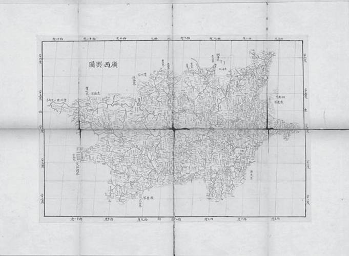
Figure 8.5. Kangxi Atlas, 1721. Map of Guangxi Province.
Photo: The British Library. https://www.loc.gov/resource/g7821fm.gct00232/?sp=11
It thus managed during the long eighteenth century simultaneously to engage with early modern mapping practices globally and to avoid alienating key imperial constituencies rooted in Chinese geographical traditions.
More on the topic The Early Modern Search for Geographic Knowledge:
- Early modern European warfare features prominently in several important discussions of early modern violence, notably the debate on the Military Revolution and its variants,
- Demonic possession and exorcism are discussed in numerous medieval and early modern written sources and have been the subjects of a great number of modern academic investigations.
- In Search of “Ukraine” in the Russian Empire (End of Eighteenth and Early Nineteenth Centuries)
- This chapter examines robbery at sea as a long-standing global phenomenon, tracing patterns of waterborne violence as they developed in eastern and western seas from ancient to modern times, with an emphasis on the early modern period.
- The place and role of knowledge of life safety basics in the modern world
- Between East and West: Understanding Early Modern Ukraine
- In the early seventeenth century Japan transitioned from a period of prolonged and nationwide internecine civil war (the Warring States period, 1467-1600) to an era of extended peace during the early modern, or Tokugawa, period.
- Early Modern Commercial Imperialism
- Intrusions and Transitions in the Early Modern Period
- Early Modern Travellers