Catchment studies measure losses of nutrients from ecosystems
What determines how long nutrients remain in an ecosystem? The retention of nutrients within an ecosystem is related to their uptake into its biological and physical pools and to the stability of their forms.
Nitrogen, for example, is more stable as part of an insoluble organic molecule, such as a protein, than as nitrate, which is more easily leached from the soil. Nutrients are lost from an ecosystem when they move below the rooting zone by leaching, and from there into groundwater and streams. Nutrients are also lost to the atmosphere as gases or small particles and by conversion into chemical forms that cannot be used by organisms.In our consideration of nutrient inputs into and losses from ecosystems, we have been referring to ecosystems as if they had definitive spatial units, but what defines the boundaries of an ecosystem? Ecologists studying terrestrial ecosystems commonly focus on a single drainage basin. This unit of study,
which is called a catchment, includes the terrestrial area that is drained by a single stream and its tributaries (FIGURE 22.12). By measuring the inputs and outputs of elements in a catchment and calculating the balance between them, ecologists can make inferences about the use of nutrients in the ecosystem and their importance to ecosystem processes such as primary production.
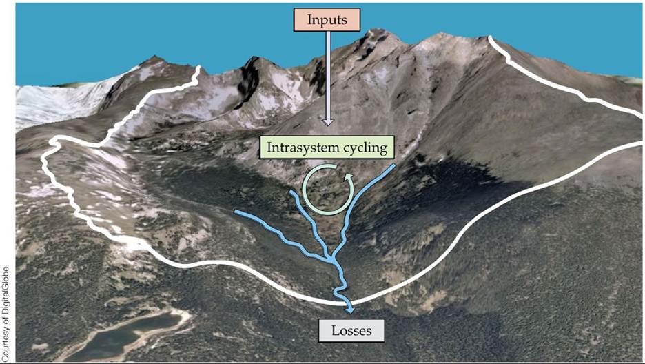
FIGURE 22.12 Catchments Are Common Units of Ecosystem Study A drainage basin (known as a catchment or watershed) associated with a single stream system (blue lines), with boundaries determined by topographic divides (outlined in white), is a unit commonly used in terrestrial ecosystem studies to measure inputs and outputs of nutrients. This catchment is the upper Hunters Creek basin, draining the south side of Longs Peak in Rocky Mountain National Park.
What assumptions are made in this simple input-output model of a catchment that may not be realistic? (Hint: Compare this figure with Figure 22.13.)
View larger image
FIGURE 22.13 presents a conceptual model of a catchment. Nutrient inputs into the catchment include atmospheric deposition and fixation. Nutrients that enter the catchment may be stored in the soil (on cation exchange sites or in the soil solution) or taken up by organisms. They are transferred within and between these ecosystem components by consumption, decomposition, and weathering processes. Nutrients are assumed to be lost from the catchment primarily in stream water, so measurements of dissolved and particulate matter in streams draining the catchment are often used to quantify these losses. In reality, the situation is often more complicated, as nutrients are also lost to the atmosphere in gaseous forms (e.g., N2 and N2O from denitrification) and as coarse particulate matter, usually fragmented litter (e.g., bits of leaves), and organisms moving out of the ecosystem. However, measurement of the input-output balance of different nutrients, using methods such as those described in ECOLOGICAL TOOLKIT 22.1, is instructive for determining their biological importance.
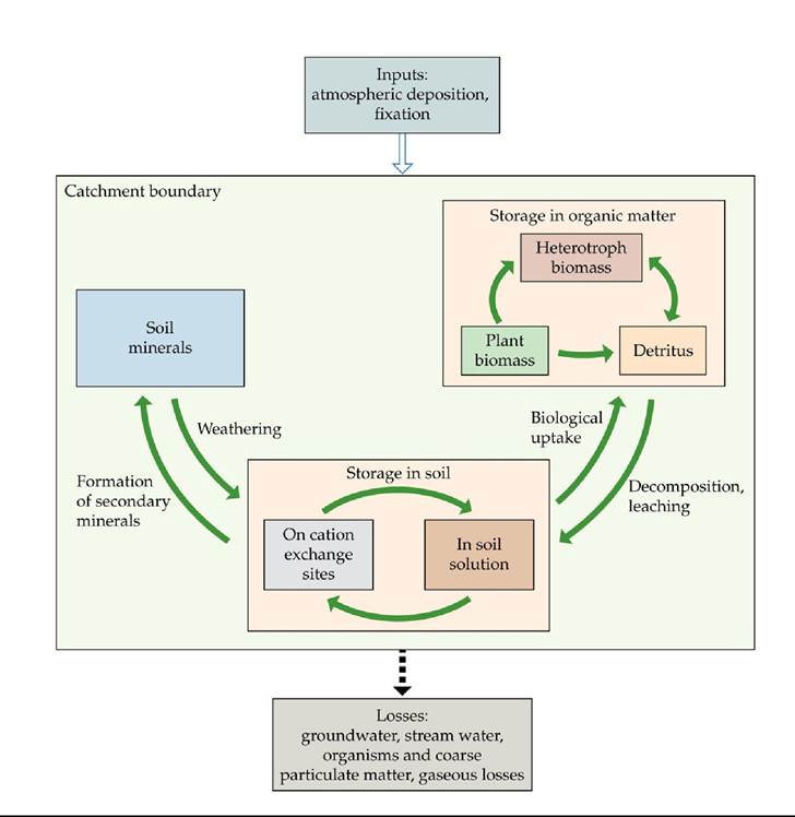
FIGURE 22.13 Biogeochemistry of a Catchment This conceptual model depicts the major pathways of nutrient movement into, through, and out of a catchment. (After G. E. Likens and F. H. Bormann. 1995. Biogeochemistry of a Forested Ecosystem. Springer: New York.) View larger image
ECOLOGICAL TOOLKIT 22.1
Instrumenting Catchments
Measuring the inputs of nutrients into catchments via atmospheric deposition, as well as their losses in stream water, requires knowing the concentrations of the elements in water as well as the volume of water entering and leaving the catchment (i.e., the amount of precipitation from precipitation gauges and stream flow from weirs, FIGURE A).
The product of the two, concentration times volume,gives the total amount of the element entering or leaving the catchment. These values are usually averaged over periods ranging from a week to a year to provide input-output balances of specific elements.
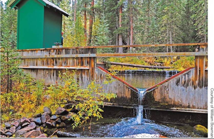
FIGURE A Measuring Water Flow A weir on Fool Creek in the Fraser Experimental Forest, Colorado. View larger image
Atmospheric deposition includes (1) elements captured in precipitation when it falls to the surface (wet deposition) and (2) particles, including aerosols and fine dust, that are transferred to the surface by gravitational fallout or air movement (dry deposition). Total atmospheric deposition can be sampled by placing buckets above the surrounding vegetation to collect the deposited material. However, buckets make good perches for birds, which may deposit their own contribution to ecosystem nutrient input inside the bucket, albeit at much higher concentrations than those found in most other parts of the catchment. This problem can be avoided by placing spiky projections around the edge of the bucket to prevent birds from landing on it. Another problem is that open buckets lose water to evaporation, increasing the concentration of the elements inside. Furthermore, in windy, cold climates, buckets are not good collectors or holders of snow because of their aerodynamics.
Wet deposition collectors have been developed that open to the atmosphere only during precipitation events and then close to prevent evaporation (FIGURE B). A moisture-sensitive surface controls a switch that opens and closes the collector. Where snow and wind occur together, windscreens help to prevent loss of snow from the bucket and enhance the capture of the deposition. Separate precipitation gauges may also be used to more accurately estimate the volume of precipitation entering the ecosystem. At regular intervals, the precipitation in the bucket or collector is analyzed for the elements of interest using chemical analyses that typically meet some government standard (e.g., in the United States, the Environmental Protection Agency provides these standards).
In many developed nations, networks of wet deposition samplers have been established to provide spatial estimates of atmospheric deposition (e.g., the National Atmospheric Deposition Program in the United States: nadp.sws.uiuc.edu; see Figure 25.19).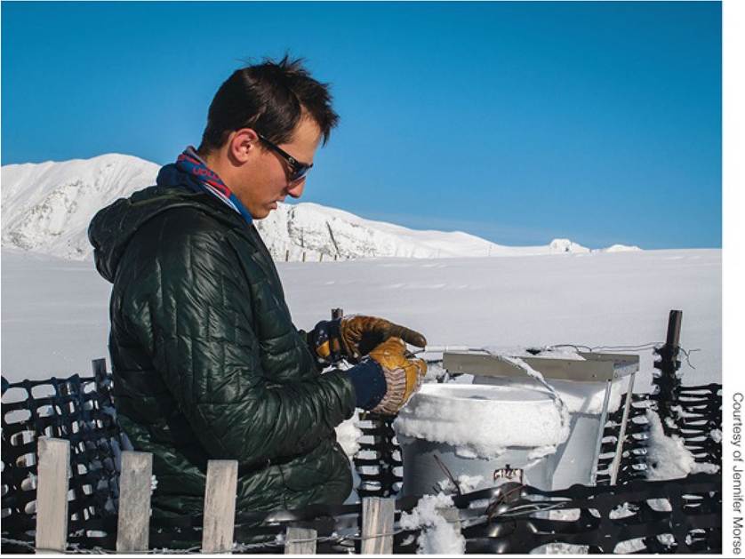
FIGURE B MeasuringDeposition A wet deposition collector is serviced on Niwot Ridge, Colorado. The bucket on the right is covered except during precipitation events. View larger image
Dry deposition measurements are more complex, usually involving collection of atmospheric samples to measure the sizes of atmospheric particles and their chemical composition. These measurements are combined with wind speed and direction measurements to estimate movements of elements to the surface. Because of the greater difficulty of the sampling and the larger uncertainties, dry deposition is measured less frequently than wet or bulk (total) deposition. In some areas, however, such as deserts or Mediterranean-type ecosystems, dry deposition is the largest component of total deposition.
The best-known catchment studies have been performed at the Hubbard Brook Experimental Forest in New Hampshire (Likens and Bormann 1995), which is considered to be representative of the northern deciduous forests of the United States. Continuous monitoring of the Hubbard Brook catchment began in 1963 under the direction of Herb Bormann and Gene Likens, whose studies have served as models for a number of other catchment-level studies. These studies are providing information about the roles of organisms and soils in nutrient retention, how ecosystems respond to disturbances such as logging and fire, and long-term trends in nutrient flows associated with acid rain and climate change.