Oceanic circulation and the distribution and topography of continents influence global temperatures
The global pattern of solar radiation (see Figure 2.6) largely explains why temperatures at Earth's surface become progressively cooler from the equator to the poles (FIGURE 2.14).
Note, however, that these changes in temperature are not exactly parallel with changes in latitude. Why do temperatures vary across the same latitude? Three major influences alter the global pattern of temperature: ocean currents, the distribution of land and water, and elevation. As we saw in the previous section, ocean currents contribute to a warmer climate in northern Europe than at North American locations of the same latitude. Similarly, the influence of the cold Humboldt Current is noticeable on the west coast of South America, where temperatures are cooler than at similar latitudes elsewhere.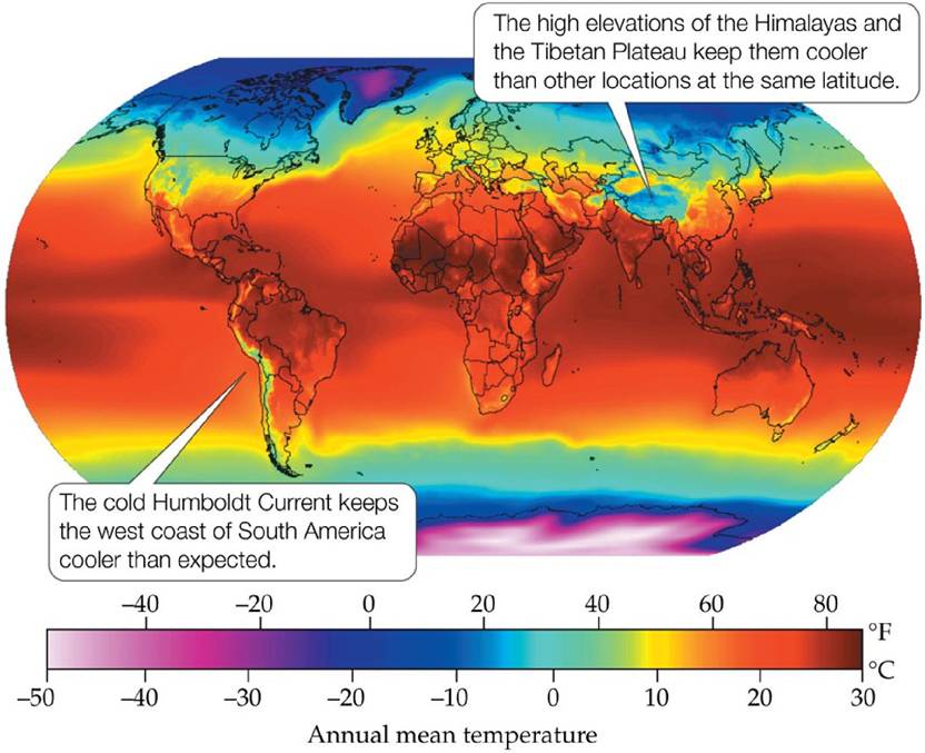
FIGURE 2.14 GlobalAverageAnnualTemperatures Averageannualairtemperatures tend to vary with latitude, but oceanic circulation and topography alter this pattern. View larger image
The difference in heat capacity between the oceans and the continents is not reflected in the average annual temperatures shown in Figure 2.14. Why is this so? Because the annual temperature variation is not depicted in that figure. Air temperatures over land show greater seasonal variation, with warmer temperatures in summer and colder temperatures in winter, than those over the oceans (FIGURE 2.15). This seasonal change has a major impact on the distribution of organisms, as we will see in later chapters.
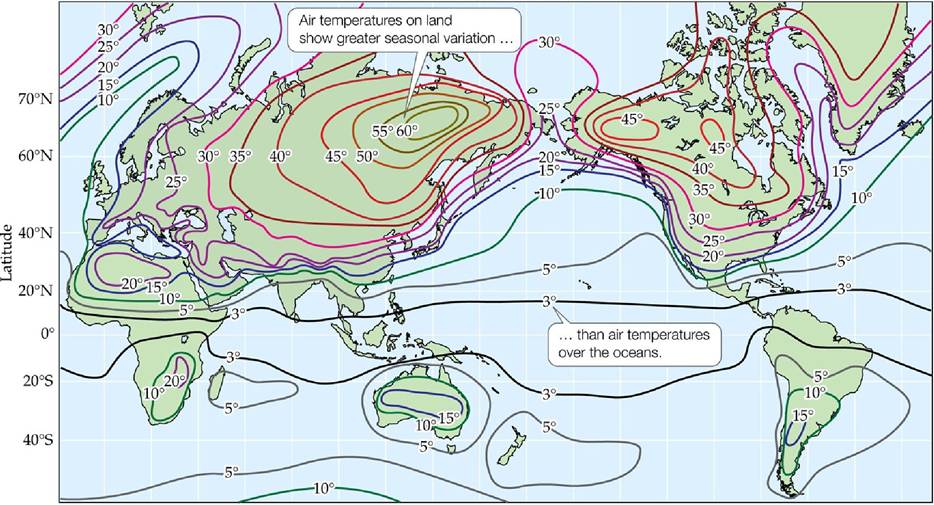
FIGURE 2.15 AnnuaiseasonaITemperatureVariation Seasonaltemperaturevariationis expressed as the difference in average monthly temperature between the warmest and coldest months (in °C).
What is the effect of continent size on the magnitude of seasonal temperature variation?
(After A. H.
Strahler and A. N. Strahler. 2005. Physical Geography, 3rd ed. John Wiley and Sons: Hoboken, NJ. Compiled by John E. Oliver.) View larger imageElevation above sea level has an important influence on continental temperatures. Note in Figure 2.14 the large difference in temperature between the Indian subcontinent and Asia. The sharp change in air temperature in this region is due to the influence of the Himalayas and the Tibetan Plateau. The change in elevation is extreme here, from about 150 m (500 feet) on the Ganges Plain in India to over 8,000 m (28,000 feet) in the highest peaks of the Himalayas in only 200 km (120 miles).
Why is it colder in mountains and highlands than in surrounding lowlands? Two factors contribute to the colder climates found at higher elevations. First, at higher elevations there are fewer air molecules to absorb the infrared energy
radiating from Earth's surface. Thus, even though highlands may receive as much solar radiation as nearby lowlands, the heating of air by the ground surface is less effective because of the lower air density. Second, highlands exchange air more effectively with cooler air in the surrounding atmosphere. Because the atmosphere is warmed mainly by infrared radiation emitted by Earth's surface, the temperature of the atmosphere decreases with increasing distance from the ground. This decrease in temperature with increasing height above the surface is known as the lapse rate. In addition, wind velocity increases with increasing elevation because there is less friction with the ground surface. As a result, the decrease in air temperature with increasing elevation tends to follow the lapse rate.