6 Trade Routes in Eastern Europe in the Eighth to Tenth Centuries
The ninth century witnessed profound changes throughout Europe. In the heart of the continent, the empire of the Frankish ruler Charlemagne had disintegrated after his death in 814, and in the far southeast the Khazar Kaganate was weakened severely as a result of nomadic invasions and internal strife.
The situation was only made worse by aggressive attacks carried out by Vikings from the north and by Islamic Arabs from the south. Arab control of much of the Mediterranean Sea disrupted trade and cut off the Byzantine Empire from its traditional economic relations with the ports of southern Europe.
6.1 The island site of Birka in the waterway just southwest of modern-day Stockholm, Sweden.
MAP 6 TRADE ROUTES, 8th TO 10th CENTURIES

Of particular importance for eastern Europe were Scandinavia’s Vikings, known also as Norsemen in western Europe. From their ports at Sigtuna and Birka along Sweden’s Baltic coast, Scandinavia’s Vikings/Norsemen—or more properly Varangians as they were known in eastern Europe—had for centuries traded with the Baltic and Finnic tribes along the eastern shores of the Baltic Sea and Gulf of Finland. So dominant was the Scandinavian presence that the Baltic Sea itself was known as the Varangian Sea.
From their Baltic and Finnic trading partners (Chuds, Ves, Merians) the Varangians heard of the riches of Khazaria on the lower Volga River and the kaganate’s lucrative commerce with the Arab Caliphate and Byzantine Empire. Anxious to tap into this market, the Varangian traders and marauders had by the eighth century opened up what came to be known as the route to the Arabs, or Saracen Route. From Birka, the Varangians crossed the Baltic Sea and sailed eastward up the Gulf of Finland.
They continued eastward along the connecting rivers and the shorelines of Lake Ladoga, Lake Onega, and White Lake until reaching the upper reaches of the Volga River. From there they sailed southward down the Volga, which gave them direct access to the Khazar Kaganate. All along this route, the Varangians set up trading posts, which eventually developed into centers of permanent settlement, much like the fur traders who opened up the North American continent several centuries later. From these posts (Staraia Ladoga, Beloozero, and Rostov being the most important) the Varangians carried furs which they exchanged for luxury items (such as silver, spices, and cloth) and metalwares (especially weapons) from the Central Asian and Arabic trade that converged in Khazaria and that continued from there on to the ultimate center of economic wealth and political prestige. That center was Byzantium’s capital and the residence of the Roman emperors of the east—Constantinople.
6.2 (Above Right and Below left) Numerous hoards of Arabic or Kufic coins and silver jewelry found in Scandinavia and along the Volga-Dnieper trade routes attest to the brisk trade the Varangians conducted with the Arab Caliphate via the Khazar Kaganate.

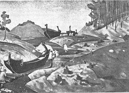
6.3 Stylized version of Varangians carrying their boats across the portage to the Dnieper River in a depiction by the 20th-century Russian painter, Nikolai Roerich.
Beginning in the 820s, Khazar control of commerce and trade in the lower Volga region was severely disrupted by a civil war caused by the revolt of one nomadic people, the Kabars, and the displacement of another, the Magyars. The Magyars were forced to find a new home in the Ukrainian steppe which they called Etelkoz and which was located between the Dnieper and Southern Buh rivers.
It was becoming increasingly obvious that the Khazars could no longer serve as effective intermediaries between the Arabs, Byzantium, and northern Europe. In such circumstances perhaps the Varangians could take their place.With that in mind, the Varangians developed an alternative trade route. After crossing the Baltic (Varangian) Sea, they traveled up the Western Dvina River virtually to its source. From there they followed a small tributary southward and then carried their boats over land (the so-called portage) to the upper reaches of the Dnieper River, where they established an outpost at Gnezdovo (just west of present-day Smolensk). The Varangians could also cross the Baltic Sea and sail up to the Gulf of Finland, reaching their outpost at Staraia Ladoga, and from there go directly south in the direction of Lake Ilmen’, not far from which they set up the outpost of Gorodishche (Scandinavian: Holmgard), later Novgorod. Crossing Lake Ilmen’, they proceeded in a southerly direction up the Lovat’ River to a point near its source. From there it was a short distance carrying their boats (the first portage) to the Western Dvina and from there on to Gnezdovo. They then sailed down the Dnieper to the Khazar outpost of Kiev. From Kiev the Varangians could travel eastward by overland route to the Donets’ River and Khazar capital of Itil’, or they could sail farther south along the Dnieper (again carrying their boats past that river’s impassable rapids) to the Black Sea and on directly to Constantinople. The route that began in Birka or Sigtuna—and that traversed the Baltic Sea, several rivers, and the Black Sea before ending at Constantinople—came to be known as the great waterway “from the Varangians to the [Byzantine] Greeks.”

6.4 Remnants of the sea walls of Constantinople.
The magnet of Constantinople and the anticipated wealth from international trade along the Baltic-Dnieper-Black Sea route is what led to an increased Varangian presence in eastern Europe and to the formation in the second half of the ninth century of the first lasting political structure that was to incorporate within its sphere all the East Slavic as well as some Finnic and Baltic peoples in the north. This new polity came to be known as Kievan Rus’.

6.5 In 866, Rus’ warriors with a fleet of 200 ships successfully attacked Constantinople and from then were a force to be reckoned with in Byzantine foreign policy; illustration from the 15th-century Radziwiłł Chronicle.
MAP 7 KIEVAN RUS’, circa 1054
