29 Ukrainian Lands under Habsburg Rule, 1772-1914
During the “long” nineteenth century, not all of what is present-day Ukraine was within the Russian Empire. About 15 percent of Ukraine’s westernmost territory was within the boundaries of the Habsburg, or Austrian Empire.
In opposition to the eastern, or Russian-ruled Dnieper Ukraine, Austrian-ruled territory is often referred to as western Ukraine. It is also useful to note that western Ukraine was subdivided into three regions—Galicia, Bukovina, and Transcarpathia—whose differing status reflected the particular administrative structure of the Habsburg Empire.The Austrian presence throughout most of western Ukraine began in 1772, when the Habsburgs annexed from Poland the palatinate of Rus’ (Galicia) and parts of the Belz, Sandomierz, and Cracow palatinates. Together these territories were formally designated as the Kingdom of Galicia and Lodomeria, or for short Galicia (German: Galizien). In the course of the next nearly half-century, Galicia’s boundaries were to change several times. In 1774 Bukovina was added to Galicia, when Austria annexed that territory from the Ottoman Empire; then in 1795 Austria acquired an even larger expanse of land along the middle Vistula River in the heart of Poland which it called West Galicia. But Galicia’s expanded frontiers were short-lived. During the Napoleonic wars Austria lost West Galicia (1809) to the Russian Empire, and for several years (1809-1815) it was forced to surrender to the tsar a strip of land along the Seret and Zbruch river valleys. At the close of the Napoleonic era, which culminated with the Congress of Vienna in 1815, Austria lost a small area south of the city of Zamość, but its eastern border with the Russian Empire was again fixed along the Zbruch River. For nearly a century, from 1815 to the outbreak of World War I in 1914, Galicia’s and for that matter Bukovina’s borders remained basically unchanged.
The third territory ruled by Habsburg Austria, Transcarpathia (or historic Subcarpathian Rus’), together with the Prešov Region, had been part of the Hungarian Kingdom since the eleventh century. When the Habsburgs inherited the Hungarian throne in the sixteenth century, Transcarpathia automatically became part of the larger Austrian realm.
29.1 The border crossing along the Zbruch River near Brody on the Austrian side of the border with the Russian Empire.
The Austrian Empire was a complex amalgam of various territories (kingdoms, grand duchies, duchies, margravates, and city-states) acquired gradually by the Habsburg dynasty since the thirteenth century. The largest of these was the Hungarian Kingdom. As for the non-Hungarian territories, they formally did not even have a name, although by convention they came to be known as the crown lands, or provinces of Austria. By the second half of the nineteenth century, Austria had seventeen provinces, two of which—Galicia and Bukovina—were in part inhabited by Ukrainians. Because Hungary continued to be governed by its own laws, the Habsburg Empire was effectively divided into an Austrian “half” and a Hungarian “half.” This territorial division was reflected in the very title of the Habsburg rulers, who were simultaneously emperors of Austria (after 1804) and kings of Hungary. With regard to Ukrainian-inhabited territories under Habsburg rule, Galicia and Bukovina were within the Austrian half of the empire, Transcarpathia within the Hungarian half.

29.2 The Galician Diet, which began to function in 1861, received its own building (built 1877-81), today the main seat of the University of L’viv.
After “re-annexing” Galicia, the Austrian imperial government abolished the old noble-dominated dietines in each of the former Polish palatinates, and in the 1780s created a centralized administration.
The province was divided into nineteen regions (German: Kreise) and it was given an advisory body, the Assembly of Estates (composed of clergy, magnates, and gentry). Real power, however, was in the hands of a governor (German: Gubernator), resident in the provincial capital of L’viv (German: Lemberg), who was appointed by and responsible to the Habsburg emperor in the imperial capital of Vienna. Initially, Bukovina was only a region of Galicia, but after several short-lived attempts in this direction, it finally became a separate Austrian province in 1861 with the same administrative structure as the other provinces. Transcarpathia never had any distinct administrative status; it was divided, as was the rest of the Kingdom of Hungary, into counties (Hungarian: megye).Beginning in the 1860s Austria entered into its so-called Constitutional Era. The office of governor in Galicia was already replaced in 1854 by that of a viceroy (German: Statthalter; Polish: namiestnik; Ukrainian: namisnyk), and in 1867 the province was divided into smaller districts (Bezirke/powiaty/povity), at first seventy-four and later eighty-three. In 1861 diets were established in both Galicia (150 seats) and Bukovina (31 seats) with deputies elected according to social status. That same year Austria created in Vienna an imperial bicameral parliament with an appointed House of Lords and elected House of Deputies. Galicia and Bukovina were each allotted seats in the imperial House of Deputies. Although not represented according to their numerical proportion of the population, Ukrainians were nonetheless elected to both the Galician and Bukovinian provincial diets and to the imperial parliament in Vienna. In 1867 the Habsburg Monarchy was renamed Austria-Hungary and transformed into a dual monarchy, whereby Hungary governed its own internal affairs, sharing with the Austrian half only common matters such as foreign affairs, currency and tariffs, and the military. Hungary continued to have a central parliament but no provincial diets like Austria had.
Ukrainians made up only a portion of the inhabitants living in Galicia, Bukovina, and Transcarpathia, and they were generally concentrated in only certain areas of those three Austro-Hungarian regions. The demographic evolution of the population in western Ukraine is shown in Tables 29.1, 29.3, and 29.5.
In Galicia, Ukrainians were concentrated in the eastern half of the province which was roughly divided by the San River. But even eastern Galicia was ethnically diverse, with Ukrainians comprising only 71 percent of the population in 1849 and 62 percent in 1910. Most of the remaining inhabitants in eastern Galicia were Poles (635,000 in 1849 and 890,000 in 1910) and Jews (246,000 in 1849 and 660,000 in 1910). The vast majority of Ukrainians lived in the rural countryside. Poles lived in several compact rural settlements throughout eastern Galicia (see Map 30) and in the region’s cities and district administrative centers. Like the Poles, Jews were divided between urban areas and the countryside, with about 60 percent living in eastern Galicia’s small towns and cities, and the remainder spread relatively evenly throughout rural villages. All these groups were represented in L’viv (German: Lemberg; Polish: Lwow), Galicia’s largest city and administrative center, which happened to be located in the eastern half of the province (see Table 29.2).
TABLE 29.1 Population of Galicia
| Nationality | 1851 | 1910 |
| Ukrainians | 2,282,000 (50.1%) | 3,627,000 (45.4%) |
| Poles | 1,864,000 (40.9%) | 3,422,000 (42.9%) |
| Jews | 313,000 (6.9%) | 872,000 (10.9%) |
| Germans | 93,000 (2.0%) | 65,000 (0.8%) |
| Armenians | 2,700 (0.1%) | 9,000 (0.0%) |
| Czechs | 500 (0.0%) | (0.0%) |
| TOTAL | 4,555,200 | 7,996,400 |
TABLE 29.2 Population of L’viv, 1910
| Nationality | Number | Percentage |
| Poles | 105,500 | 51.0 |
| Jews | 57,300 | 27.8 |
| Ukrainians | 39,400 | 19.1 |
| Others | 3,900 | 1.9 |
| TOTAL | 206,100 |
In Bukovina, Ukrainians were concentrated in the northern and western parts of the province. With regard specifically to that part of the former Austrian province within present-day Ukraine (i.e., northern Bukovina, see Map 30) its population consisted in 1910 of 303,000 Ukrainians (38 percent), 272,000 Romanians (34 percent), and 102,000 Jews (13 percent), among others.
The Ukrainians lived primarily in the mountainous regions and northern rural lowlands south of the provincial capital of Chernivtsi (German: Czernowitz; Romanian: Cernăuţi); see Table 29.4. The Jews lived in rural villages and small towns. No single group dominated Bukovina’s administrative and provincial capital.TABLE 29.3 Population of Bukovina
| Nationality | 1851 | 1910 |
| Ukrainians | 145,000 (38.0%) | 303,000 (38.1%) |
| Romanians | 185,000 (48.5%) | 272,000 (34.2%) |
| Jews | 12,000 (3.1%) | 102,000 (12.8%) |
| Germans | 26,000 (6.8%) | 72,000 (9.1%) |
| Poles | 4,000 (1.1%) | 35,000 (4.4%) |
| Magyars/Hungarians | 5,600 (1.5%) | 10,000 (1.3%) |
| Armenians | 2,200 (0.6%) | — |
| Czechs | 1,800 (0.5%) | 1,000 (0.1%) |
| TOTAL | 381,600 | 795,000 |
TABLE 29.4 Population of Chernivtsi,1910
| Nationality | Number | Percentage |
| Jews | 23,600 | 27.8 |
| Germans | 17,800 | 20.9 |
| Ukrainians | 15,300 | 18.0 |
| Poles | 14,900 | 17.5 |
| Romanians | 13,400 | 15.8 |
| TOTAL | 85,000 |
In Transcarpathia, the three dominant groups according to the 1910 census were Rusyns/Ukrainians—(324,000 or 54 percent), Magyars/Hungarians—(159,000 or 26 percent), and Jews—(87,000 or 14 percent). The Rusyns/Ukrainians were concentrated in the northern and eastern parts of the region, basically in the Carpathian mountain ranges and foothills. The Magyars lived exclusively in the rural areas of the southeastern lowland plain near the Tysa River and in the small towns of Uzhhorod, Mukachevo, and Berehovo (see Map 30).
The Jews lived in mainly rural villages but most especially in the towns, where they comprised in some cases nearly half the population.TABLE 29.5 Population of Transcarpathia
| Nationality | 1850 | 1910 |
| Rusyns/Ukrainians | 217,000 (45.1%) | 324,000 (54.1%) |
| Magyars/Hungarians | 128,000 (26.6%) | 159,000 (26.5%) |
| Romanians | 51,000 (10.6%) | 11,000 (1.8%) |
| Jews | 41,000 (8.5%) | 87,000 (14.5%) |
| Slovaks | 24,000 (5.0%) | 6,000 (1.0%) |
| Germans | 11,000 (2.3%) | 10,000 (1.7%) |
| Others | 9,000 (1.9%) | 2,000 (0.3%) |
| TOTAL | 481,000 | 599,000 |
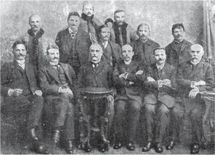
2.3 (Above) Ukrainian deputies to the Galician Diet, 1908.
2.4 (Below) Ukrainian villagers in eastern Galicia on their way to cut hay; photo by František Řehoř.

Throughout the historic nineteenth century Ukrainian lands within Austria-Hungary remained economically underdeveloped. The vast majority of the population was engaged in small-scale agriculture and related pursuits. Until 1848 nearly three-quarters of the population in Galicia, and an even higher proportion in Bukovina and Transcarpathia, were serfs attached to the land and owing labor duties to their landlords. After their emancipation in 1848, the “free” peasants remained what one might call “economic serfs.” Because they held only smallsized plots of land that at best provided a subsistance-level existence, the peasant farmers were more often than not in chronic indebtedness to the larger landowners and money lenders. The resultant poverty prompted largescale emigration, which from the 1880s to 1914 saw the departure of an estimated 430,000 Ukrainians from Galicia and Bukovina and another 170,000 Rusyns from Transcarpathia, most of whom headed for the industrial regions of the northeastern United States.

29.5 The Polish gentry in 19th-century eastern Galicia liked to don historic dress for celebratory occasions, in this case a wedding.
The main reason for Galician underdevelopment was the Austrian economic policy that had been set in the late eighteenth century. The Habsburg government aimed to transform its empire into a self-sufficient economic unit in which its eastern regions, including Galicia and the entire Hungarian Kingdom, would provide raw materials to more industrialized western provinces (Bohemia, Moravia, and Lower Austria). The western provinces would, in turn, sell their finished products to Galicia and Hungary, which effectively became internal colonies of the empire.

29.6 Jewish shop owner selling sewing materials at the market in Zhydachiv; photo by František Řehoř.
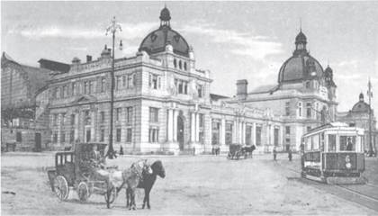
29.7 L’viv was connected by railroad to the Habsburg imperial capital of Vienna in 1861; the city’s main railroad station (still functioning and recently restored) was opened in 1904.
The development of railroad lines beginning in the 1860s (see Map 30) only reinforced the empire’s overall economic policies. Galicia’s provincial capital of L’viv was connected via Cracow to the imperial capital of Vienna, and this allowed goods from the western industrialized regions to be dumped even more easily on the Galician market. At the same time, the relatively well-developed railroad network throughout Galicia, Bukovina, and Transcarpathia (totaling 2,294 miles or 3,700 kilometers in 1914) provided easier transport for those who wished to emigrate. Some Galician viceroys tried to promote industrial development after the 1880s, and a vibrant petroleum industry developed around Drohobych and Boryslav (producing 4 percent of the world’s oil by 1914), but this did not change in any significant way the generally underdeveloped agrarian nature of all Ukrainian lands in Austria-Hungary.

29.8 Oil fields in Drohobych.