I The Oldest Ocean
I
The Pacific Ocean is far and away the largest ocean, covering a third of the Earth’s surface, and the distance from Sumatra to the Ecuadorian shore at the Equator is around i 8,000 kilometres.
Even if Polynesian sailors may, very occasionally, have landed on the shores of South America, regular contact between the opposing shores was non-existent before the Spaniards launched their Manila galleons linking the Philippines to Mexico in the sixteenth century. In the midst of the sea there lie the hundreds of islands in the dozens of archipelagoes that make up Polynesia, Micronesia and Melanesia, three broadly defined zones whose ethnic distinctiveness from one another was much exaggerated by nineteenthcentury anthropologists. Some strings of islands, such as the Solomon Islands, are closely enough packed for the inhabitants to be able to see or in some other way detect the presence of close neighbours. Others, notably Easter Island (Rapa Nui), the Hawai’i islands and New Zealand (Aotea- roa) are well out of sight of the nearest landfall, and in the last two cases some way removed from the main lines of Polynesian navigation.Within this vast space, however, there are extraordinary signs of unity. Captain Cook and the natural historian Joseph Banks explored immense tracts of the Pacific in the years around 1770, and they were intrigued to find that the languages spoken in Hawai’i, Tahiti and New Zealand were mutually comprehensible and that what are now called ‘Oceanic’ languages were spoken across the whole north-south span of Polynesia. ‘It is extraordinary,’ Cook stated, ‘that the same Nation each having adopted some peculiar custom or habit etcetera never the less a carefull observer will soon see the Affinity each has to the other.’1 Indeed, later research showed that these languages were related to the language now spoken in Malaysia and Indonesia, and even to the Malagasy language of Madagascar, all forming a large ‘Austronesian’ group of languages.
Polynesian vaka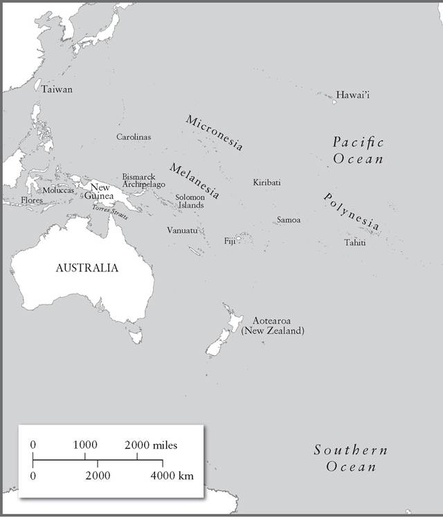
or waka, the term for a canoe, matches Malay wangka. Reconstruction of the ancestral Austronesian language, based on a remarkably rich common vocabulary concerned with ships and navigation, reveals that the distant ancestors of the Polynesians were maritime folk, who spoke of canoes commanded by captains with outriggers, platforms, masts, sails or paddles, and even carved prows and sterns.2 That said, the eerily beautiful languages of the Pacific had broken away from those of south-east Asia many millennia ago, suggesting a common linguistic origin among the early settlers in the Pacific. It is important to use the phrase ‘linguistic origin’, because language and ethnic origins may be at odds with one another.3
The Pacific was both the first area far from land to be settled by humans, tens of thousands of years ago, and the last. That statement needs to be qualified: a few small, uninhabited islands in the Atlantic and in the Indian Ocean were settled from the fifteenth century onwards, places such as Madeira, St Helena, Mauritius, that will be seen to have played a role out of all proportion to their size in the maritime networks that came into existence as the Portuguese, the Dutch and other rivals claimed dominion over the sea routes across the world; and Antarctica, with no permanent population, can be left out of account. But the last substantial territory to be colonized by humans was New Zealand, whose settlement is variously dated somewhere between ad 950 and 1350. Even though many of its original inhabitants, who were at first concentrated on the warmer North Island, lived in the interior away from the sea, stories about the arrival of the first canoes abounded; the Maoris and the Hawai’ians had no doubt that they were migrants. Once settled, the Maoris lost interest in large ocean-going seacraft and confined their navigation to boats better suited to coastal waters.
They could say little about the place from which they had come, other than that it bore the all-too-common name Hawaiki, a name that conveyed a sense of ‘the place where our ancestors lived long ago’. Further north, among the chains of islands, movement across the sea generally remained the norm. These were people who treated the sea with the familiarity that Tuaregs might show to the Sahara desert or Incas to the mountains of the Andes: these were all obstacles that could be overcome, with precise knowledge, determination and confidence.Over several millennia an extraordinary maritime culture had come into being, out in the middle of the ocean, lacking long shorelines, great ports and access to long rivers bringing produce down from the inner parts of massive continents. Instead, it was a largely interconnected world consisting of atolls, coral reefs and volcanic islands: a very diverse world, offering very different opportunities to those who settled, and thereby providing a great stimulus to local and even l ong-distance exchange.4 These Polynesians lacked the elaborate tools available to navigators, most importantly the art of writing. Their knowledge was passed down orally, and yet it was extremely detailed, very accurate and in many respects superior to the instruments of the western navigators, such as Magellan and Cook, for whom the Pacific was a sea of constant surprises and uncertainty. There is a simple point that sums up the mastery over the seas accomplished by the Polynesian navigators: apart from a northern route across the Atlantic, managed for several centuries by the Vikings and their descendants, western European sailors did not venture deep into their neighbourhood ocean until the end of the Middle Ages.
It is difficult to reconstruct the process of settlement. Did it occur from west to east across the islands of the Pacific, or should we think instead of a series of spirals that gradually encompassed the islands, creating several distinct networks of settlement? When did the pioneers arrive? If we cannot even date their arrival in the last territory, New Zealand, with confidence, it is all the more difficult to do so on small islands where archaeological research has been spasmodic, based as much on serendipity as carefully constructed programmes of excavation.
What sort of boats did the first navigators employ? Across the Pacific there developed different types of boat, with different shapes of sail (lateen, square, claw and the upside-down triangles known as sprit sails). But the most challenging problem of all is why the navigators went looking for more islands. The question is rendered more difficult by the fact that there were phases of expansion and phases when expansion ceased. It is also complicated by the often fiery disputes between the experts, some of whom have tried to prove their point by getting on board and sailing the seas in reconstructed Polynesian ships.In this account of the settlement of the Pacific islands some substantial territories are largely missing: Japan, Taiwan, the Philippines, the islands of Indonesia. They maintained a close relationship to the Asian mainland and formed the outer edges of what might be described as little Mediterraneans, the Japan Sea and Yellow Sea in the north, and the South China Sea (which has often been compared to the Mediterranean) in the south. Another territory, the Australian continent, was inhabited by people some of whom used the sea as a source of food, and who greatly respected the sea, but made no known attempts to venture across the waves once they had settled in their arid continent. The main concern here is with the open ocean, with communities scattered over Polynesia, Micronesia and Melanesia who inhabited small islands, New Zealand apart, and whose remoteness was generally no barrier to lively interaction across hundreds and even thousands of miles.
II
The antiquity of navigation across the Pacific is demonstrated by the arrival of humans in Australia. The distances involved were smaller than nowadays, because sea levels were much lower between 140,000 and 18,000 years ago, while much water was locked in northern ice floes and glaciers. At one extreme, the sea level stood 100 metres lower than present levels, but within that time frame it rose and fell, so at some points it was only about twenty metres lower than nowadays.5 During this era, the Pleistocene, the Australian continent encompassed the whole of New
Guinea and Tasmania; but it remained isolated from continental Asia (which included Java) by stretches of open sea dotted with islands that have been given the name Wallacea, after Darwin’s illustrious contemporary.
This separation, which took place 40,000,000 years ago, ensured that animal species unique to Australia continued to flourish there, especially marsupial mammals. There was a sort of island bridge linking south-east Asia (named Sunda by the geologists) to Sahul (Australia and New Guinea), and it included the small island of Flores. Here we encounter the first great enigma. In 2003 archaeologists excavating a cave shelter on Flores discovered the remains of several early humans, dating very roughly to the second half of the low-water period and possibly several centuries later; more recent discoveries suggest that other early hominids reached as far as the Philippines.6 These people were very small, a little over a metre in height, and their brain capacity was no greater than that of a chimpanzee. However, other physical features make it clear that they were an early form of human. Their small size was most probably the result of adaptation to the restricted diet of the island, similar to the dwarfism found in other species across the world that have lived in challenging environments. If that is so (and that is only one if) they probably descended from earlier, taller hominids who had managed to reach Flores before about 100,000 bc; but since then, and ever after, the island has been isolated from ‘Sunda’ and the Asian mainland by a stretch of sea. Setting aside the speculations of nineteenth-century theorists that the inhabitants of the Pacific were a separate creation of mankind by God, we are left with evidence that early humans crossed the sea, by whatever means we can only guess. It has also been suggested that the Flores humans (unkindly nicknamed ‘hobbits’ by the press) co-existed with modern humans on the island around 12,000 bc, and that memories of these little people survive in folk tales; but such folk tales are so widespread in every human society that it is hard to believe they are credible. The evidence is further complicated by the contemporary survival on Flores and in parts of the Philippines of stegodons (animals related to elephants) which seem to have reached these places by swimming across the sea. Flores remains a mystery.That modern humans (Homo sapiens sapiens) reached further still more than 60,000 years ago is clear from discoveries right across New Guinea, Australia and Tasmania (then joined to Australia). There are finds of axes from northern New Guinea that can be shown to be 40,00060,000 years old.7 In 2017 Australian archaeologists announced the discovery of a rock shelter in northern Australia that contained implements dating back to 65,000 years ago, and wondered whether there was interaction between what seem to be the first Australian members of Homo sapiens and other types of human who could still be found in east Asia, notably the mysterious Denisovans, who are thought to have been similar to but different from the European Neanderthals.8 There is therefore no doubt that the original Aborigines (very possibly the ancestors of the modern ones) arrived on the continent more than 60,000 years ago; and they must have done so by crossing spaces of over a hundred miles of open sea, often finding themselves out of sight of land.9 Archaeologists sometimes express surprise and puzzlement at the idea that early humans of the sapiens type could have turned into sailors. But it is not at all surprising; as humans, of various types, moved out of Africa to colonize much of the world by land they had to cross rivers, and used the skills learned on rivers to cross lakes; and having learned about lakes seas were a challenge, but one that could be met. Short sea journeys taken by the first humans to move eastwards on the route out of Africa may well have included a crossing of the Red Sea near Aden and a crossing of the Persian Gulf near Hormuz. These early humans had plenty of mental equipment, which they turned to good use in establishing that extraordinary mastery over nature that the Australian Aborigines still possess. It makes more sense to insist on that ability than to speculate about the types of boats these travellers might have used; bamboo, logs, bark boats, reed boats and much else have been suggested, but no archaeological evidence has been found, which is hardly surprising; if any remains survive from the very earliest journeys they lie on the l ong-submerged coast of the Sahul con- tinent.10 So the best answer is that in 65,000 years of travel boat designs must have changed, and that in any case boats would have been adapted to appropriate conditions; sails might have been developed where wind was a vital factor in reaching a place, but not when inter-island navigation was possible in calm waters within sight of land.11
When looking at the relationship between the original inhabitants of Australia and the sea several considerations have to be borne in mind. One is that exploitation of the coastline for food, whether that involves fishing from boats or foraging on beaches, does not provide proof of l onger-distance travel across the sea and of the making of connections with other communities, either elsewhere in Australia or on islands beyond its shores. Another is that the use of modern evidence, such as Aboriginal opinions about the nature of the sea, though unavoidable, is very problematic. Tribes have moved around; physical conditions have changed; Aboriginal technology has also changed, as the people of the land have adapted themselves to local conditions, and as contact with Europeans has radically (and often disastrously) transformed daily life, inherited knowledge and social attitudes.
At various times the Australian interior was more hospitable to life than it is now, and the earliest settlers headed inland, looking for fresh water; Aboriginal tribes began to colonize the coastlines rather later, about 30,000 years ago at most, judging from current archaeological evidence; no site older than around 33,000 bc has been found on the coast. The continent remained very lightly populated; there was apparently no pressure to occupy coastal land, because food was readily available elsewhere. Shells found at cave sites a little way into the interior show how links were forged between coastal settlements and the population of inner Australia; but these shells almost certainly came as ornaments rather than food, and early sites close to the coast often reveal a diet based as much, or much more, on local fauna such as wallabies, rather than fish.12 But the interior became increasingly arid, and living on the coast became more attractive; stone fish traps found in the Kimberley region, on the north coast of Western Australia, have been dated to a maximum of 3,500 years ago, but there is every reason to argue that these are the lineal descendants of earlier fish traps that were widely used along the Australian coast.13
These fish traps were a common feature of life in the Torres Strait Islands, the chain of islands between Australia and New Guinea. Nowadays it is standard usage in Australia to speak of ‘the Aboriginal peoples and the Torres Strait islanders’, recognizing the distinct status, origin and culture of the people of these islands, whose technology has long been more advanced than that of the Australian Aborigines: more Neolithic than Old Stone Age. Ethnically, they are closer to the peoples of Papua New Guinea and Melanesia, and in recent times at least cultural influences from New Guinea have been profound, including myths, rituals and technology. In the Torres Strait, groups of people could be found who operated very different economies: some who depended on small-scale agriculture, and others who were ‘saltwater people’, making extensive use of the sea, including voyages back and forth between islands and to the coasts of both New Guinea and Australia, setting out in dugout canoes with outriggers and sails.14 Some of these influences from the north were then transmitted along the north-east coast of Australia to Aboriginal peoples living by the sea: masks and headdresses of types familiar from Papua New Guinea were being used along the shoreline when the first Europeans explored what is now known as Queensland, and other borrowings may have included types of harpoon and fish hook. In modern times, fish and sea creatures such as turtles and dugongs completely dominate the diet of the Torres Strait islanders, supplying about two thirds of a kilo per day, on average. Saltwater people using bark boats went out into the open sea to catch pelagic fish, that is, fish that live near the surface of the sea. They developed trading links with their neighbours, which can be traced back with certainty to around ad 1650 when Indonesian merchants from Macassar became regular visitors; however, all the signs are that this was a much more ancient connection, and that as a result of wider contacts some Aboriginal peoples such as the Yolgu (roughly pronounced Yol- ngu) knew a little about the world beyond their coastline.15
In the Torres Strait, on the island of Mer - which, according to one legend, was a giant dugong who lay down in the middle of the sea and became land - evidence abounds that this area had become a trading station at the centre of a lively network of maritime trade, certainly 2,000 years ago but almost certainly in the much more distant past as well.16 The bones of dogs, rats, dugongs, turtles and of many types of fish provide part of the proof that the rich resources of the sea were fully exploited, but a bone pipe dating to around ad i indicates wider trading links. The islanders appear to have developed outrigger canoes that made contact across the sea safe and regular. Their style of boat influenced the design of canoes along the coast of Queensland.17 The islands of the Torres Strait, then, and their sea-based population, formed a sea bridge between the cultures of prehistoric Melanesia and those of northern Australia which, thanks to the sea, were not as isolated from the outside world as is easily assumed. The Torres Strait islanders were venturesome sailors, but others were much more cautious in their dealings with the open sea. One Aboriginal people in Australia insist that the sea is alive and that it has angry moods during which it is likely to kill people: ‘when you are on the sea you mustn’t say anything bad about it. Not criticise it. Because the sea is alive, like a person. So you must respect it.’18 On Croker Island, not far from Darwin in the Northern Territory, the Aborigines claim that the great Rainbow Serpent inhabits the seabed and has to be placated through special rituals, because the serpent will use the sea to kill and maim. In the same region, the Yanyuwa people describe themselves as ‘people who originate in the sea’,19 and their boats, like the sea, became animate. Humans could impregnate their boats with magical power by singing ‘power songs’ that would calm the sea and that would stay inside the boat, as if it possessed its own soul.20
It was to the north of New Guinea that really striking changes would occur, with the colonization of the Pacific islands. Some islands off the north coast of New Guinea were colonized 35,000 years ago. The Solomon Islands were being visited 29,000 years ago, and raiders from New Guinea remained a threat to Solomon islanders over the centuries.21 The Admiralty Islands were settled 13,000 years ago, if not earlier, and these involved a sea journey of nearly 100 miles, including navigation out of sight of land.
One site, on Buka in the Solomon Islands, yielded evidence that the diet of the settlers around 26,000 bc included fish and shellfish as well as mammals and lizards.22 But man cannot live by fish alone, and the availability of one vital necessity was counterbalanced by the lack of other necessities. Sometimes there was no hard stone suitable for cutting. In that case it was necessary to obtain obsidian or another prime cutting stone from further afield. Although the distance is not great, obsidian from New Britain has been found on New Ireland, both in the vicinity of New Guinea, and assigned a date of 20,000 bp (‘Before the Present’). There are plenty of doubters, however. It has been suggested that times of low sea levels are precisely the times when there is no incentive to cross the sea, because there is more land to colonize. When the sea level rises, the land shrinks and people go in search of new land.23 But all this is speculation. We simply do not know.
Ill
The name given to the culture that spread across vast tracts of the prehistoric Pacific is ‘Lapita’. Amid all the speculation it is no surprise to find that this is not the name any people gave to themselves, but the name of the archaeological site where their distinctive culture was first identified. An extraordinary feature of Lapita culture is its spread. No other prehistoric culture embraces such a large geographical area, in this case including both the Solomon Islands, which had been settled very early, and islands as remote as Fiji and Samoa.24 The vast majority of the islands where Lapita settlers arrived were virgin territory, far beyond the range of the earliest Austronesian navigators. That is not to say that the Lapita navigators were the descendants of the earliest Austronesian settlers who had ventured beyond New Guinea millennia earlier. The genetic identity of the Lapita people remains uncertain, and the best answer is that they consisted of a mix of peoples of various origins who gave rise to the varied populations of Polynesia and much of Melanesia; the uniformity of their culture was not necessarily backed by uniformity in their appearance, and woolly-haired Melanesians and straight-haired Polynesians (those are already generalizations taken too far) participated in a single culture. Rather, this culture seems to have had an initial focal point in the western Pacific, probably in Taiwan, where the language of the indigenous population is related to those spoken across Oceania; and later on it was disseminated outwards from newer focal points deeper in the Pacific, notably Samoa. Taiwan was itself home to a lively prehistoric culture in the third millennium bc, and pottery found in the northern Moluccas is strikingly similar to that of the Polynesian Lapita, suggesting ancestral links to the inhabitants of the islands off the south-east coast of Asia. As speakers of Austronesian languages mixed with the population along and off the coast of New Guinea, an ethnically mixed population came into being, whose varied origins are reflected in their DNA. The route they took, over many centuries, therefore began in the Bismarck archipelago before they spread eastwards through the Solomons.25
Lapita represents a change of gear in oceanic expansion. Until about 1500 bc local exchanges between islands are easily provable from fragments of obsidian, the sharp-edged volcanic glass that was traded between islands, in return for what it is hard to say - probably foodstuffs, but even the term ‘trade’ must be used with caution; people may simply have gone out to volcanic islands to collect the material off the beaches. The Lapita folk brought pottery, which is their distinctive archaeological ‘signature’, and they brought animals for which there is no earlier evidence in the islands, notably pigs, dogs and domestic birds.26 They also brought Pacific rats, and the bones of these stowaways can be used to date the arrival of navigators in islands across much of the Pacific; here again the evidence strongly indicates gradual movement from west to east.27 In broad terms, they were a Neolithic (‘New Stone Age’) people or group of peoples, familiar with agriculture, stock-rearing and ceramics.28 Farming transformed the environment of one island after another, as land was cleared for agriculture and as local species of birds were hunted, eaten and driven to extinction; the most famous case, much later, would be the giant moa birds of New Zealand, but there were local crocodiles and giant iguanas that proved unable to resist human conquest.
On the other hand, the settlers proved to be experts in agronomy, for they transformed the often limited resources of islands in Remote Oceania (the area around Fiji and Samoa) that were so isolated that they offered few fruits and none of the tubers which provided the staple starch in their diet. Twenty-eight species of plant have been identified that were brought across the ocean by the Lapita people: bananas, breadfruit, sugar cane, yams, coconuts, wild ginger and bamboo were some of the most significant, though different types of island were suited to different types of plant - yams flourished best in Melanesia. (Another arrival was the sweet potato, apparently from South America, which raises the question of whether Polynesian navigators at some stage reached the opposite side of the Pacific.) The proto-Oceanic vocabulary, reconstructed by philologists, offers words for planting, weeding, harvesting and the mounds under which yams were grown, once again suggesting that the horticultural traditions of the Lapita went far back in time to the days when their ancestors lived in Taiwan.29 The arrival of plants from places further west suggests that the voyages eastwards were indeed colonizing ventures, and were not accidental discoveries by lost navigators stranded on desert islands, a question to which it will be necessary to return. The movement of the Lapita peoples across the ocean may not seem rapid. One estimate for the time taken to reach western Polynesia from the Bismarck archipelago is 500 years. Yet this may only represent twenty generations, which in the larger scheme of things makes this expansion quite fast, even, in the timescale of prehistorians, explosive.
The motives behind this movement of people are hard to fathom. One historian of Polynesian navigation, David Lewis, identified a spirit of adventure - a ‘restless urge’ - among Polynesians, citing the Raiateans from Tahiti, who would go voyaging for several months, touring the islands of that part of the ocean. They were observed by Joseph Banks, Captain Cook’s scientific companion, so the evidence is late and somewhat circumstantial. David Lewis also pointed to the ‘proud self-respect’ of the navigators, a pride that would prompt sailors to set out to sea in bad weather if, for instance, they saw that the natives of an island they were visiting were taking to the sea, even just to fish. This idea fits well with the concepts of honour and shame of which anthropologists studying these ocean societies have written. Viking-style raids between islands have also been postulated; one could imagine a first phase during which the raiders took away coconuts, obsidian and breadfruit that they found on deserted islands; then, following settlement, inter-island wars were certainly com- mon.30 But these cases suit a world already partly settled; the question here is how and why the settlement occurred in the first place. Overpopulation might seem the obvious choice, but there is not enough evidence to suggest dense settlement of the western islands and intolerable pressure on resources.31
As the settlers moved further eastwards, they left behind diseases brought millennia ago from New Guinea and eastern Asia, such as malaria - unsullied island habitats are often healthy, and offer a long life expectancy. But the longer people live and the healthier they are, the greater number of children they can expect to have, with a better chance of survival to adulthood. In such an environment younger children might take part in migration almost as a matter of course, on the proven assumption that there were plenty of places to settle out in the ocean. The Polynesians set great store by genealogies, emphasizing the rights of eldest children, while sibling rivalry is a constant feature of Polynesian legends, suggesting that younger sons were well advised to keep on the move till they found a new homestead.32 One idea is that the early Polynesians were primarily dependent on what the sea offered - ‘ocean foragers’ - and that the search for the produce of the sea brought them further and further out into the ocean, followed by the development of farming settlements as the pioneers bedded down in their new homes. In ‘Remote Oceania’ their seafood diet included not just oysters, clams and cowries but turtles, eels, parrot fish and sharks; most of this fishy diet came from the edges of the reefs or from even closer to shore. There is no evidence of short-term camps as voyagers squatted in islands; they arrived in new places and they created homes there; and they preferred to live on the shore, carefully choosing sites that offered access to the open sea through gaps in the reefs that surrounded many of the islands. There they built wooden houses on stilts, a type of house widely dispersed throughout the Austronesian world. This was not a sudden invasion of strings of uninhabited islands, but a process of steady expansion eastwards (not necessarily in a straight line).33
The pottery evidence is so remarkable because it shows clearly that this was a single culture with regional variations. The pottery was handmade, without the use of a wheel, and without kilns, meaning it was probably fired out in the open. Here we have a common ‘dentate’ style, where pots were often stamped with a tooth-shaped instrument, and intricate patterns were created with great artistry. These patterns have been seen as a sort of vocabulary, conveying messages now lost; there were also local variations in the pottery styles, and the most striking fragments to have survived show incised human faces, or at least features such as eyes. Possibly these represent gods or ancestors, and the designs may have been similar to those used in tattooing, which was widespread (tattooing instruments have turned up in excavations). The spread of this pottery through ‘Remote Oceania’ provides vital clues about the arrival of the first humans on islands deep within the Pacific. The inhabitants of the Bismarck archipelago were making Lapita-style pots around 1500 bc. Over the next century or so the pottery reached ‘Near Oceania’ (Vanuatu, Kiribati and neighbouring island chains). By 1200 bc it was being produced in Samoa. Interestingly, only the oldest pottery from Fiji shows such concern for intricate decoration. Was this art lost over a generation or two? Did the decoration lose its significance, particularly in new societies which were not yet part of networks of reciprocal exchange? Oddly, as the Lapita people moved still further eastwards they brought their plants and animals, and their knowledge of navigation, but eventually lost interest in pottery entirely.34
There was a single culture; but was there a shared culture? Chemical analysis of the clay proves that pots were carried from island to island, though no doubt some were moved around the Pacific simply as utensils containing the food navigators needed; many undecorated pots would have been suitable for use as containers for sago flour, which kept well and provided ideal nutrition for navigators. Care needs to be taken with the assumption that the movement of these goods and other items such as obsidian and chert (the class of rock that includes flint) adds up to ‘trade’. Trade might be defined as the systematic exchange of goods, for which a notional though generally variable value is set. In Pacific island societies, as the great ethnographer Bronislaw Malinowski showed, the exchange of goods was not simply concerned with commercial acquisition; reciprocal exchange was a means by which individuals established their place in the social and political pecking order, a way of establishing claims to leadership and of emphasizing who was a client to whom.35 This would be even truer of societies that experienced plenty, as these island communities generally did; and yet there were certainly foodstuffs and tools, most notably cutting implements and adzes, that were not to be found on coral atolls and that needed to be obtained over the water. The closer one looks at this world, the more connected it appears to be.
An example from the western end of the Lapita world provides rich evidence. Talepakemalai lies on the northern edge of the Bismarck archipelago. The history of this village can be traced over five or even seven centuries, beginning halfway through the second millennium bc. At that point, early in Lapita history, obsidian arrived from islands not far away, as well as adzes and chert for making tools, plus pottery from twelve sources, not all identifiable but all distinct in the composition of their clay. Meanwhile the islanders were adept at making fish hooks, and also decorative jewellery consisting of beads, rings and other objects created out of shell. Archaeologists therefore speculate that some sort of exchange network linked Talepakemalai to a series of island communities in western Near Oceania. Yet by the first millennium the early expansion had slowed, a process mirrored in the contraction (or ‘regionalization’) of this part of the Lapita world. This could reflect a greater degree of autarky, that is to say, less need to rely on neighbours for certain types of goods, which could now be produced locally. The local economy perhaps strengthened, but what the archaeologists tend to see is less evidence for external links, which gives the illusion of Lapita decline. This may have some bearing on a phenomenon to be observed in a moment, the long interval between the Lapita expansion and a new phase of exploration and settlement in the first millennium ad.36
We know very little about Lapita boats. One or two rock carvings offer clues to the shape of sails (including an interesting ‘claw’ shape, with a roughly triangular profile, but with a concave top line); but much depends on the Austronesian words reconstructed by philologists, because nothing of the original boats survives in the archaeological record. Broadly, we can conceive of sailing vessels with outriggers, similar to those used in later centuries; some may have been catamarans, though double canoes of this sort seem to have developed mainly in Remote Oceania, around Fiji. By modern times the variety of boats was considerable, but they conform to a common type: sailing vessels whose builders paid close attention to their stability.37 It was understood that a single hull did not suit small boats in high seas. Polynesian boats were hard to topple; and those that set out for new lands must have been large enough to carry men, women, supplies of food and water (often stored in bamboo tubes), domestic animals and seeds or tubers ready for planting in new lands. Those heading for familiar territory evidently carried goods to be exchanged, such as ceramics, local produce of the soil, and tools or blocks of stone for making into tools. No doubt there was great variety, though some features, such as the use of vegetable fibres to tie together the components, were probably standard. These bonds, made of coconut fibre, were strong and resilient, and rendered the hull more secure because of the flexibility they offered.
Navigators had to face strong challenges. The most obvious were the easterly winds. Colonization of the Pacific occurred in the face of the wind rather than as a result of happy accidents as sailors were caught in the wind and carried to unknown islands. The trade winds and the currents all point westwards; the trade winds cross the Lapita area of settlement from south-east to north-west, forming a coherent band that matches quite well the Lapita area. The Pacific currents consist of four main trans-Pacific movements: a southern current lying away from all the islands; the South Equatorial Current heading westwards with a slight southward inclination; and above the Equator two contrary currents that separate Hawai’i from the rest of the Polynesian world. Looking at the South Equatorial Current, as with the winds, the broad shape of movement from Samoa westwards very roughly coincides with the zone of Lapita settlement. Evidently, Polynesian navigators perfected the art of sailing against the wind; they needed to ensure that they could return from their explorations, and the best way to do that was to challenge the winds and currents, tacking back and forth, moving slowly but securely.
As they developed these techniques over many centuries, they also learned the art of dead reckoning, judging distance as they sailed to gain some sense of longitude; they appear to have found this easier to do than European sailors, who had to await the invention of the chronometer in the eighteenth century to be sure of their longitude. Tupaia, a Polynesian navigator who accompanied Captain Cook, astonished Cook’s companions by his almost instinctive awareness of where the ship stood, without instruments or written records. The Polynesian navigators proved that one can solve some challenging problems without any technology at all, just the super-computer of the human brain.38 As for latitude, much easier to judge, they observed the stars: ‘to travel between the south of the main Solomons and the Santa Cruz group was as simple as following a zenith star path - east or west - with the seasonal winds.’39 Knowing the stars was the key to successful navigation. This was not casual knowledge but a science learned during a long apprenticeship, through practical experience and by way of an elaborate oral tradition; it was a secret science, intended for carefully chosen initiates who would be able to navigate the boats while the rest of the crew performed more humdrum tasks.
Even in the 1930s these methods were taught to boys, beginning at the age of five, as the story of a celebrated sailor from the Carolinas named Piailug reveals. Once his grandfather decided that the boy should become a navigator, he had to spend his time listening to stories of the sea and acquiring information about the science of navigation. His grandfather assured him that as a navigator he would be better than a chieftain, would eat better food than others and would be respected throughout society. By the age of twelve he was travelling the ocean with his grandfather, and he began to master the secrets of the sea - the movement of birds, the changing map of the stars, but also magical lore. All this was committed to memory, leading to a full initiation around the age of sixteen which involved a month of seclusion during which his teachers bombarded him with the knowledge he needed. He had no use for written texts, but he made models out of sticks and stones that he could memorize and rebuild, when the time came to instruct the next generation in the art of naviga- tion.40 In the Carolinas, navigators would prepare a sidereal compass, a chart of the key points in the night sky, which in modern times they greatly preferred to a magnetic compass; in other parts of the Pacific similar compass-type charts were constructed out of sticks and stones to show wind direction or the movement of the sun across the sky.41
The Polynesians did not necessarily require a compass of any sort. There is the story of a schooner captain who lost his compass overboard and confessed to his Polynesian crew that he was lost. They told him not to worry, and took him where he wanted to go. Puzzled by the ease with which they had achieved this, he asked how they knew where the island was. ‘Why,’ they replied, ‘it has always been there.’42 The extraordinary confidence Polynesian navigators possessed in their methods can also be judged from an interview with a navigator from the Marshall Islands conducted in 1962: ‘we older Marshallese people navigate our boats both by feel and by sight, but I think it is knowing the feel of the vessel that is the most important.’ He explained that a practised navigator would have no difficulty sailing in daytime or at night, and that it was important to take proper account of the movement of the waves:
by the boat motion and the wave pattern a Marshallese sailor who has been trained in this kind of navigation may know if he is thirty miles, twenty or ten, or even closer, to an atoll or island. He also knows if he has lost his way, and by looking for a certain joining of the waves, he will be able to get back on course.43
In cloudy weather, any break in the clouds at night-time had to be exploited immediately; but there were other signs, such as the swell of the sea, that a practised navigator could use to identify where the boat was heading. There were plenty of additional signs, various combinations of which made a landfall a certainty. Land could be detected through the flight of birds such as terns coming out to sea to feed. Their range from land was known; the direction they came in the morning and returned at night was the best possible clue to where land lay. Other signs included cloud formations, which might change colour, reflecting the land that lay underneath (coral atolls would cast an opal tinge on the cloud above). Phosphorescent patches in the sea were a further sign that land was near. Increasing amounts of flotsam generally suggested land.44 The very smell of the sea air would help guide a sailor to a known haven.45 It was important to compensate for currents and wind, making use of the sun by day and the stars by night to adjust course as appropriate. One of the most extraordinary methods of navigation was what might be called the Polynesian Theory of Relativity, a system known in the Carolina Islands as etak. Here, the assumption was that the boat remained still and the rest of the world moved. Judgements therefore had to be made about how the position of the islands altered in relation to the boat - a relationship not just between the boat and its destination, but between the destination and another island in the vicinity; the method depended on placing this third point accurately in relation to the stars. This was not perhaps Einstein; but it involved some powerful mental geometry, not to mention an astonishingly detailed, carefully memorized, mobile map of the heavens.46
It is therefore completely wrong to conclude that without writing there can be no exact science, even if the navigational science of the Polynesians had a good share of incantations, magical practices and invocation of the gods. The extraordinary understanding that Polynesian sailors developed of the sea and its whims, and the increasing evidence that they settled the islands in the face of the winds rather than by being blown towards landfalls, has significant implications in explaining the voyages. Much ink has been spilled contesting the apparently plausible views of Andrew Sharp, whose book Ancient Voyagers in the Pacific, first presented to the Polynesian Society in 1956, insisted that those who found new land by and large did so by accident, when they were blown off course or otherwise lost. Sharp did not challenge the argument that Polynesian sailors were exceptionally skilled, but he did underestimate their remarkable abilities.47 What Sharp really demonstrated was something else: we still do not really know why the Lapita people and their successors, including the Maoris, settled one territory after another across the vast expanse of ocean. We can say with some confidence how it was done, and more or less at what periods it was done (though, even there, there is forceful disagreement). Why they kept on the move is a topic for speculation.
The period of rapid Lapita expansion reached a climax around 1000 bc when Vanuatu and the Fijian islands were settled. This involved ambitious journeys well out of sight of land, particularly to reach Fiji; there were a few more stepping stones on the route eastwards that led the Polynesians to Samoa and Tonga. The Lapita had reached the limits of their expansion, and had created a series of networks across about 4,500 kilometres of the Pacific, in a great arc from New Guinea to Tonga.48 Just as great a mystery as the origins of Lapita expansion is its cessation for up to a millennium. Was this because Polynesian boats were unable to venture on to the vast tracts of open ocean separating Lapita lands from Hawai’i, New Zealand and Easter Island? The problem with this argument is that Lapita sailors had already managed to reach Fiji and Samoa, well out in the ocean.49 These were very skilled and imaginative navigators, and it is hard to believe that they were incapable of adapting their already impressively durable boats to face stormier seas. Overpopulation was apparently not a strain on them. A fine ecological balance had been achieved, despite the radical replanting of large tracts of soil on the islands. The problem with materialistic explanations is that migration in many parts of the world has often been stimulated by religious beliefs that are impossible to recover so far back in time. Supposing for the moment that the Polynesian explorers were guided by a religious imperative to seek the rising sun (an argument for which, admittedly, there is hardly even circumstantial evidence), then cultural fashions could have changed as religious ideas altered. Once the cult of local ancestors developed strongly, a greater sense of being rooted in the island where one lived would act as a brake on further expansion - though not, as it turned out, indefinitely.