Songs of the Navigators
I
Pacific navigation revived by the fifth century ad. Why this should have happened is as uncertain as why it had ceased in the late Lapita period. A link to the so-called Little Climatic Optimum has been suggested, but this does not quite fit the chronology, which suggests a revival of navigation at least a couple of centuries earlier.
Rising sea levels during warmer weather might have made life difficult on low-lying islands with plantations by the shore, stimulating migration.1 Only in the millennium after about ad 300 did settlement expand north and south, and much further west, into areas of varied climate and resources, as far as Hawai’i in the north and New Zealand in the south. During this phase Tahiti and the Society Islands were one focus of settlement, beginning around ad 600, if evidence from domesticated coconuts on the island of Mo’orea is given full credit; however, the earliest inhabited sites on these islands that have actually been discovered date from somewhere between 800 and 1200, although many earlier sites may be under water as the coastline has altered.2The journey northwards from Tahiti or the Marquesas to Hawai’i may have taken three to four weeks, and winds blowing in various directions had to be managed: first east to west, then west to east, and finally east to west again. Attempts to mimic the Polynesian voyages during the 1970s, led by Ben Finney in the canoe Hokule’a, showed that the journey was manageable. Finney, along with the New Zealander Jeff Evans, has been a pioneer in reconstructing traditional boat types and in encouraging the Polynesians to take an interest in their ancient navigational skills, and his experimental voyages are taken seriously.3 A more difficult question is whether the Hawai’i archipelago was settled immediately after discovery by a group of migrants bringing plants and animals, including pigs and dogs, as in the island chains further south.
It cannot be assumed that the settlement of Hawai’i, a whole group of islands, was a single event; different islands may have been colonized at different times, sometimes from neighbouring islands in the archipelago, and sometimes from the island chains much further south, around Tahiti and Samoa.The Hawai’ian islands cannot have been discovered by accident; the winds simply do not permit an accidental arrival from, say, Samoa.4 People had gone in search of new islands, and they now ranged far from those with which they were already familiar. This must have tested their navigational abilities to the limit. They no longer had sight of such night-time star guides as the Southern Cross. Once they were in the northern hemisphere they had entered what was for them a new world. Oral traditions told of discoveries and of journeys back to the starting point to carry the news that there was new land to settle. These oral traditions are full of fascinating information about navigation and even some remembered history, but how well that history was remembered, amid many miraculous accretions, including giant octopuses, is a moot point.
A distinction began to emerge between two basic types of society in Polynesia, the so-called open societies, in which a variety of different groups, including warriors and priests, competed for power and land, and what are called stratified societies, of which early Tahiti and Hawai’i are good examples, where there was much less fluidity and a clearly defined elite emerged, with power concentrated in the hands of hereditary chieftains. On Tahiti and its close neighbours in the Society Islands the chieftains expected tribute payments of food and bark-cloth; they expressed their power through their intimate ties to the war god Oro, a relationship they sealed by acts of human sacrifice.5 Around ad 1200, the Tahitians began to build terraces and to lay out orchards where they cultivated breadfruit. They built storage pits for the breadfruit.
They also constructed stone temples with platforms, or marae, that stood right by the ocean and sometimes jutted out into it. War canoes would set out from the marae, and a new chieftain would arrive by boat for his installation. These were societies wedded to the sea. Chieftains from some of the less well-endowed islands to the east preyed on the richer central islands, and managed to extract tribute from them. Leadership in war, celebrated in the cult of Oro, consolidated the hold of chieftains from the lesser isles over neighbouring territories. Little maritime empires came into being, and chieftaincies were by no means confined to a single island or part of one. Tension between chieftains, and in particular between their sons, would explain the urge to go and seek new lands, without quite explaining why the new burst of colonization occurred when it did. Arriving in already populated islands could, however, be dangerous: in some places it was apparently the custom to kill newcomers the moment they were found.6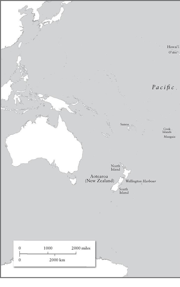
II
The deep interest understandably shown by American archaeologists in the ancient history of the fiftieth state in the Union is matched by a profusion of evidence from the archipelago. There is the archaeological evidence; but there is also the evidence, hard though it is to assess, of elaborate oral traditions recorded in the nineteenth century, at a time when reading and writing had become a passion among the Hawai’ians - this was the result of energetic Christian missionary activity, and for a time resulted in higher literacy than in the United States.7 Moreover, the islands have attracted attention because organized hierarchical states came into existence without parallel in the Polynesian world.8 The Polynesian settlers found a paradise: whereas each of the atolls and reefs of the island chains of the south Pacific had an individual character, marked by limitations on what could be produced in often unpromising soils, Hawai’i was a veritable garden, well endowed with volcanic soil, though with some variety between the islands.
Evidence from O’ahu shows that settlement was under way along the shoreline by 800, though the first arrivals may have occurred several centuries earlier, suggesting that this was not a one- off settlement that then grew prodigiously. Particularly eloquent, if that is the right word, are the rat bones from O’ahu and elsewhere. Pacific rats could only have arrived in such remote places by travelling as stowaways, or possibly as a live food reserve, on Polynesian canoes. Many rat bones have been found in sinkholes dated to somewhere between ad 900 and 1200.9It is generally agreed that these settlers came from the Marquesas Islands, because of similarities between the tools used in both places, notably adzes and fish hooks, though contacts were probably flowing both ways, so it is hard to be sure who influenced whom, and a new style of fish hook adopted around 1200 indicates links with the area around Tahiti. It will be seen that oral tradition spoke of close links to Tahiti and the Society Islands, at least in the fourteenth century. So we can think of settlers converging from two main directions, whether or not one group had heard of the discovery of the islands by the other group. Among the tales about early voyages that were still being related in nineteenth-century Hawai’i, two stand out, even though the assumed date of the events is some point in the fourteenth century ad. These dates depend on calculations of generations that are, to put it mildly, approximate. Hawai’ian narrators were not interested in exact dates. They measured time by the names of the rulers, and inevitably some reigns were longer than others.
The tales told of voyages across vast swathes of the Pacific, reflecting an era before Hawai’i became closed off from the rest of Oceania.
One story begins on the outer island of O’ahu, where the ruler Muli’eleali tried to divide his section of the island among his three sons, in the same way that he had inherited one third of O’ahu from his own father.
But the obvious problem was that generation by generation there was less land on which to subsist. His two youngest sons therefore rebelled and were sent into exile, moving to the larger island of Hawai’i itself. They introduced new methods of irrigation that had been developed on O’ahu in order to cultivate staple root vegetables (notably taro), but a combination of hurricanes and floods wrecked their work, and they decided that they had had enough of the Hawai’ian islands; they would return to the land of their ancestors, a place called Kahiki. If there is any truth in the story, they sailed their double canoe to what is now south-western Tahiti, an area with striking cultural similarities to Hawai’i: the Taputapuatea temple in this part of Tahiti bears an identical name to the Kapukapuakea temple in northern O’ahu, allowing for a sound shift that converted t to k in the Hawai’ian dialects (so Kahiki is a Hawai’ian version of Tahiti). One of the brothers then decided he was homesick and returned north, where he made a very successful marriage to a chieftain’s daughter and found himself appointed a paramount chief of Kaua’i, an outlying island beyond O’ahu. But his father-in-law had left behind a son from another marriage he had made in Kahiki/Tahiti, and the story tells of journeys back and forth to Kahiki. Another rather gory tale recounts the experiences of Pa’ao around the same time. He originated in the Society Islands. When his son was accused by Pa’ao’s brother of stealing breadfruit, Pa’ao cut his son open to show that his stomach was empty, and then rolled his canoe out to sea over the body of his nephew, the child of the brother who had made the accusation. That meant that two lines of succession were obliterated in the feud. He set out for Hawai’i, building temples and generating a new line of descendants, who became an important dynasty of hereditary priests in the Hawai’ian islands. Reduced to essentials, these tales indicate an ease of movement between Hawai’i and Tahiti or the islands around Tonga that persisted into the fourteenth century.One of the tales preserves a song that is as clear about the memory of at least partly Tahitian origins as one could wish:
Eia Hawai’i, he moku, he kanaka, He kanaka Hawai ’i - e, He kanaka Hawai’i, He kama na Kahiki...
Here is Hawai’i, an island, a man, Here is Hawai’i - indeed, Hawai’i is a man, A child of Tahiti... 10
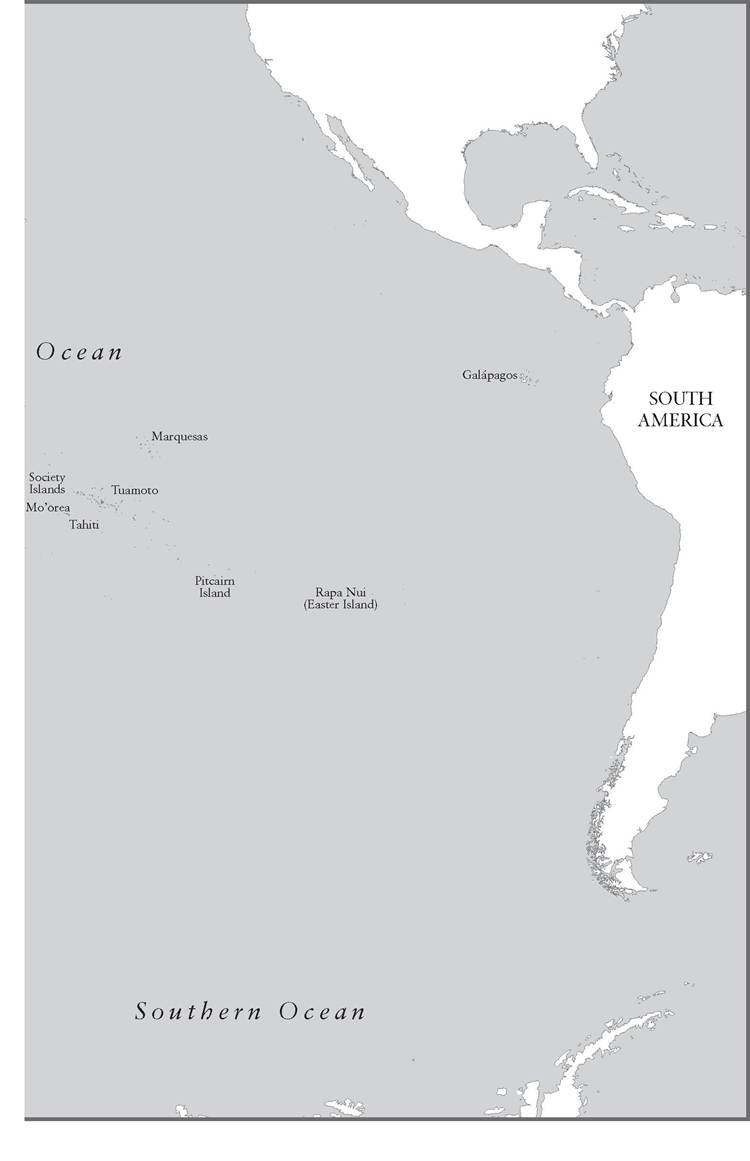
Proof that these stories are not total fantasies has been provided by DNA evidence that links the modern native Hawai’ian population to the population of the Marquesas, in eastern Polynesia, and to the Society Islands a little further west.11 Archaeological finds have been more reticent about contacts between Hawai’i and the Society Islands. An adze made of stone from Hawai’i fashioned in Tahitian style and found 2,500 miles away on a coral island in the Tuamoto archipelago provides minute but precious evidence of contact. This ‘hawaiite’ rock could only be traced back to Hawai’i. Around Tuamoto, adzes were produced from stone carried from a wide range of islands around south-eastern Polynesia; to have identified a Hawai’ian example, even just one, indicates lengthy (though not necessarily direct) links far beyond obvious trading neighbours. Alas, it is impossible to date this type of material securely.12
The oral traditions about later happenings on Hawai’i have nothing to say about sea journeys after the time of Pa’ao and the men from O’ahu. All the archaeological evidence too indicates a caesura: Hawai’i, for whatever reason, became secluded from the rest of the Polynesian world. Around 1400 a long pause in voyaging out of Hawai’i began, despite the continuing circulation of oral traditions about the inhabitants’ arrival across the sea.13 Yet this did not reflect contraction at home in Hawai’i. The population grew rapidly, reaching about a quarter of a million by the time Captain Cook arrived in the late eighteenth century. Whatever tension this created as the land became ever more densely populated was resolved partly by war and partly by the assertion of strong central authority by the chieftains - a process, in some interpretations, of ‘state formation’. As in Tahiti, the war god, here named Kuy, was propitiated by human sacrifice; the stone temple platforms became increasingly elaborate; and in time the chieftains claimed divine descent, thereby marking themselves out clearly from the common people. These ordinary islanders worked on the land controlled by lesser chieftains, offering their labour services and regular tribute. All this was a source of great enrichment to the greater and lesser chieftains, for the growth in population was also addressed: it was reflected in ever greater intensification of agriculture, with organized field systems, fish farms where mullet were encouraged to breed, and irrigation projects, under the patronage of the god of flowing water, Kane. By the sixteenth century something like an organized state had emerged in Hawai’i, a stratified society that might very loosely be described as ‘feudal’.14 The fertility of the land and the efficiency of Hawai’ian agriculture had reduced dependence on the sea, except for local fishing. The islands had never depended on the rest of Polynesia for vital goods - they were too far away. They became little continents, turned away from the sea that had borne their first settlers to their safe havens.
III
Before turning eastwards to Rapa Nui (Easter Island) and southwards to New Zealand, the last part of Oceania to be settled, a question about contacts right across the Pacific needs to be addressed. Since Polynesian navigators reached as far east as Rapa Nui, isolated in vast tracts of open ocean, is it conceivable that some reached further still and arrived in South America? The search to identify the first people to reach America is based on any number of false premises, beginning with the assumption that people would recognize what they discovered as part of two massive continents (something that Columbus, for one, failed to do); they would then deserve to be hailed as the ‘true discoverers’ of the New World. But the question of links between Polynesia and South America was posed in the reverse form - South Americans reaching and indeed colonizing Polynesia - by the Norwegian explorer and self-publicist Thor Heyerdahl. He became obsessed by the idea that the Polynesians were of American descent, and that they took advantage of the easterly winds to sail their boats deep into the Pacific. He insisted that he could see Native American influence on innumerable Polynesian artefacts. The raft he constructed, Kon-Tiki, bore no resemblance to the type of vessel used by Polynesian navigators all the way across Oceania; it was copied from Peruvian sailing rafts deployed after the Spanish conquest of the Inca Empire.15 Nonetheless, in 1947 he sailed his raft across the open ocean, miraculously survived the experience, and assumed that just because it was possible to land (in his case, crash-land) in Polynesia such voyages must have happened in the past. Evidence from DNA and from the spread of the Austronesian languages unequivocally demonstrates that the Polynesians migrated from west to east and not from east to west; and even if Crick and Watson had yet to identify the structure of DNA when Heyerdahl set sail, the linguistic evidence had long been clear. This did not prevent Heyerdahl being voted the most famous Norwegian of all time (rather than Amundsen or Nansen, just to mention Norwegian explorers), nor did it prevent the construction of a much-visited museum in Oslo where his strange ocean-going craft is displayed.
The diplomatic view of modern Norwegian scholars is that Heyerdahl opened up some important questions. And the question about links between Oceania and South America is a real one. There is evidence for contact in the era of Polynesian navigation, though it is not easy to decipher. Most of the supposed similarities between objects produced in Oceania and along the American coastline have functional explanations; it is not beyond the capacity of human beings to invent the same simple item at different times and in different places. This applies for instance to harpoons, fish hooks manufactured out of shell, and plank-constructed boats of the sort favoured by the Chumash Indians off Santa Barbara, California, and in much of Polynesia.16 The Chumash Indians are often cited as the sort of people who might have ventured across the sea, since they were busy boatbuilders, specializing in journeys between the mainland and the Channel Islands opposite Santa Barbara; they were also one of the most economically sophisticated peoples along that coastline, with a monetary system based on a currency made out of pierced shells (periodically destroyed to prevent rampant inflation). But their boats were hard-pressed to cross the Santa Barbara Channel in rough weather and were far too small and simple to venture out into the open ocean; besides, fish supplies were plentiful in inland waters.17 As one goes down the American shoreline the impression of societies interested in the sea solely for coastal fishing strengthens: the Kumiai Indians of Baja California loved sardines, sole, tuna (including bonito) and shellfish, but were not navigators; they used small reed boats, often capable of carrying just a couple of people.18 Nor do these peoples show any sign of receiving goods from distant Polynesia.
Thor Heyerdahl was anxious to show that the Galapagos Islands, with the rich fishing grounds around them, were the first stepping stone into the Pacific for his supposed Amerindian navigators. This, he hoped, would embarrass the often virulent critics of his Kon-Tiki expedition.19 Since the Galapagos lie 600 miles west of Ecuador, reaching them would have been no mean achievement; they were discovered, or maybe rediscovered, by the Spaniards in 1535, and it is no surprise that a fair amount of Spanish pottery was found when Heyerdahl and his companions went to look for evidence of early visits to the islands a few years after the Kon-Tiki expedition. Although the Norwegians identified dozens of other fragments of pottery as South American, mainly from Ecuador, they had to admit to uncertainty about the dating of much of what they found, which was very simple pottery that could have been made before or after the Spanish conquest of the Inca Empire. Some more elaborate fragments may simply show that in the sixteenth century native Indian potters perpetuated styles from the Inca era - one would expect nothing less, since the overwhelming majority of the population remained Indian. So we can conclude that South American Indians did venture out on ships at least as far as the Galapagos; the question remains whether these were Spanish galleons or the balsa wood rafts in which Heyerdahl placed his faith, and the most likely explanation is that the pottery arrived aboard galleons. Nonetheless, the Incas did preserve myths about rulers going out to sea on mysterious voyages, and maybe these should not be totally discounted.
The best evidence for pre-Spanish contact is provided by plants that are very unlikely to have travelled such great distances by natural means, surviving winds and seas without being destroyed: bottle gourds and sweet potatoes spread across the Pacific, but originated in South America; in the other direction, coconuts reached Panama. The word used by the Quechua Indians in South America for the sweet potato, kamote, has been imaginatively compared to Easter Island kumara and Polynesian kuumala.10 Seasonal winds made journeys to South America possible, but there is no evidence for any attempt to settle there and no evidence for active commerce between South America and any part of Polynesia.21 It might be argued that the sweet potato was diffused by the Spaniards when they gained control over trans-Pacific trade routes in the sixteenth century. However, the places where they were most actively cultivated lay some way from the Spanish trade routes - Hawai’i, New Zealand and Easter Island - and carbonized tubers of sweet potato excavated by archaeologists in New Zealand, Hawai’i and Mangaia can all be dated to the period before the arrival of the Europeans. Mangaia lies in the Cook Islands, part of Remote Oceania situated north-east of New Zealand; its specimens have been carbon-dated to about ad 1000. While it is possible to imagine birds carrying seeds across many thousands of miles, tubers are another story. It is therefore safe to say that Polynesian navigators extended their range right across the Pacific during this extraordinarily ambitious second phase of expansion.
Even more remarkable than possible contact with the admittedly vast landmass of South America, impossible to miss if you go far enough eastwards, is the settlement of Rapa Nui, or Easter Island, in the middle of nowhere. And yet, by contrast with Hawai’i, it at least lies on the plane of Polynesia, and reaching Rapa Nui posed less of a challenge in dealing with the winds. There are probably as many theories about the significance of the island’s enigmatic giant statues as there are statues. The question here is, rather, by what means navigators reached Rapa Nui and what sort of outside contacts the islanders maintained after its discovery and settlement. Heyerdahl, naturally, saw Easter Island as one of the first bases of his pioneering Peruvian sailors; the locals obliged him by offering him pieces of South American pottery, but they were just modern Chilean ceramics (the island is governed by Chile) - they wanted to keep the eccentric Norwegian gentleman happy.
The first difficulty is agreeing on a date for settlement. One version of the islanders’ own traditions told how the inhabitants were led there by Hotu Matu’a from Hiva, who was seeking the sunrise; his name merely means ‘Great Parent’. There are several islands in the Marquesas group, to the north-east of Rapa Nui, that contain the word ‘Hiva’ in their name, and, as has been seen, the Marquesas may well have been the source of the Hawai’ian population.22 These traditions also report a six-week voyage inspired by Hoto Matu’a’s tattooist, who said he had dreamed of a fine volcanic isle to the east. The striking feature is not so much the detail in the story but the awareness that the islanders had come across the sea, and that the world consisted of more than their own island, a view that, in their extreme isolation, they could easily have held, and that other less isolated island peoples have held.23
Counting the fifty-seven generations said to have elapsed between Hotu Matu’a and the recording of the legend one reaches a date of ad 450; but such methods, as will be clear from New Zealand, are without much merit, and some of those working with the same oral material have produced dates in the twelfth or even the sixteenth century. Fortunately modern science resolves the difficulty, up to a point: Carbon 14 dating shows that settlers were already installed on Rapa Nui around the end of the seventh century ad (690+130), a date derived from material found at a temple platform. Yet this too is not a flawless way of establishing dates; an even earlier date of ad 318 came from a grave that also contained a bone dated ad 1629. The language of the islanders, though clearly Polynesian (as seen in the place names especially) has distinctive features that lead linguists who specialize in glottochronology to conclude that it broke away from neighbouring tongues around ad 400; it mixes features from western and eastern Polynesian, and there has been time for a local vocabulary to develop, such as the word poki (child). The islanders also developed a very distinctive script, or possibly brought it along from somewhere else that abandoned its use, though that is to assume that the script was not developed after contact with and in imitation of the Europeans. It was a sacred script, almost always inscribed with care on wooden panels; unfortunately no attempt at decipherment has been totally convincing.24
Rapa Nui is best known for the remarkable statues and temple platforms that pepper Easter Island. The high period of construction stretched over several hundred years from 1200 to 1600. The statues, which originally looked away from the sea and towards the volcanic interior, apparently represented ancestors, while the often elaborate platforms seem to have been used not just for rituals but as astronomical observatories, so that the loss of interest in navigation was evidently not accompanied by a loss of interest in reading the skies. Local priests saw the night sky as a calendar that they used to fix their festivals.25 Cut off from the rest of the world, the island tried to survive from its own resources, but, steadily denuded of tree cover by its inhabitants, Rapa Nui became impoverished. Environmental collapse provides the best explanation for the end of the era of prosperity that brought these platforms and statues into being - indeed, over the following centuries statues were cast down, the inhabitants went to war with one another, often living in caves, and competition for scarce resources intensified.
Easter Island may well be the great exception to the general rule that islands were searched out deliberately; whether or not it was found by accident, it remained off the mental map of the Polynesian navigators. Like Hawai’i and New Zealand, it did not feature on the hand-drawn map the Polynesian navigator Tupaia prepared for Captain Cook, which only extended as far east as the Marquesas.26 Pitcairn Island too was cut off from the rest of Polynesia and was empty when the mutineers from the Bounty arrived in 1790; but it had been inhabited in the past, as stone remains were found - clearly there had been an extremely isolated population that had died out or emigrated. And a similar story can be told of Kiritimati (in Kiribati), to which the mutineers eventually moved.27 Some attempts at colonization were simply not successful, because the fortunes of these island communities depended on their position within still larger communities of islands that interacted across the ocean through trade, warfare and marriage ties.
These most remote islands, then, were the realms of Pluto and the outermost planets, places beyond the outer edge of the interactive world of the Polynesian chiefdoms, who warred with one another, whose people traded with one another, and who preserved over generation after generation their unwritten but detailed and highly effective science of navigation. That still leaves untold the discovery and settlement of what are by far the largest islands in Polynesia, and the most inhospitable climatically: the North and South Islands of New Zealand.
IV
The history of the discovery of New Zealand has always been a tangle. In European accounts, Abel Tasman and Captain Cook appear prominently, as explorers who found the islands and who worked out their shape. That is to ignore the native Maori population of what the descendants of the original settlers still call Aotearoa, a name attributed to Hine-te-aparangi, the wife of Kupe, the first Polynesian navigator to reach North Island - the mountainous, often cold, South Island was visited and was lightly settled over the centuries, but the great majority of Maoris would choose to live in the warmer north. The Maori name of the island means ‘Long White Cloud’ (ao + tea + roa, ‘cloud white long’), because that is what Kupe’s wife thought she saw when she first approached its shores, not realizing that this was land. Calculating back the generations, orthodox opinion places the discovery of New Zealand in the middle of the tenth century ad, a date often refined to 925, though more modern research insists that the supposed founder may have arrived as late as the middle of the fourteenth century, assuming that these genealogies have any merit at all and that Kupe really existed, or indeed that he was not more than one person.28 This was supposedly followed by a second settlement, led by a certain Toi, around 1150, and then the arrival of a whole fleet of canoes in about 1350. That, at least, was the view accepted both by Maoris and by Pakeha (white Europeans) who tried to write the very early history of New Zealand in the nineteenth and twentieth centuries. Kupe was enthusiastically described as the ‘Columbus, Magellan or Cook’ of the Maoris, a historical figure who certainly existed and who was the most eminent representative of hundreds of generations of Polynesian navigators in the Pacific.29 A Maori song began:
Ka tito au, ka tito au,
Ka tito au ki a Kupe,
Te tangata nana i hoehoe te moana,
Te tangata nana i topetope te whenua.
I will sing, I will sing,
I will sing of Kupe,
The man who paddled the ocean,
The man who divided up the land.
The difficulty is that all the information we have about Kupe is derived from oral traditions, impressive in their command of the finer details of genealogy, so that even the names of the wives of slaves are given, but packed with legendary materials - sometimes a giant octopus, sometimes tribes of goblins, not to mention canoes that turned into stone and a miraculous belt that churned the surface of the sea. Just because the art of navigation was transmitted orally and was evidently a very exact science, we cannot assume that this genealogical information deserves the same credit; indeed, these genealogies vary from place to place, with generations added and subtracted to accommodate the traditions of local chieftains. History and symbolism were mixed together, and then contaminated by contact with the Pakeha.30 Nor is there a single agreed account of Kupe’s career; in one version Aotearoa was the name of Kupe’s canoe.
These oral traditions themselves were written down, admittedly by Maoris, but under the influence of British missionaries and other modern settlers. In one version Kupe sees his god Io in a dream, and the god says to him: ‘Go forth upon the great ocean... take and possess yourself of some land which I will show to you.’ The strong echoes here of the story of Abraham being led to Canaan by God indicate that this tale tells one more about the impact of Christian missionaries than about Maori traditions. The most vocal critic of attempts to use these tales as history has called them ‘modern New Zealand folktales’.31 That said, they are illuminating both for the stories they tell about the original settlement as the native inhabitants of Aotearoa imagined it and for the information they convey about navigating the open ocean. At their core is the certainty that the settlers came from far across the sea, and that their ancestors lived in a place called Hawaiki. It has been seen that the letter k becomes t in some Polynesian dialects, and in others a glottal stop is often used instead of either, so Hawaiki is another form of the name Hawai’i; or, rather, Hawai’i took its name from a supposed ancestral home much further to the south, to which the Maoris also attributed their origins.32 They did not claim to have come from the island group now called Hawai’i. Once again, though, it is important not to be too credulous. The name ‘Hawaiki’ was a generic term for the place of one’s ancestors - ‘the old country’, as it were, whose name was reused again and again to confer a sense that connections to those ancestors had not been lost by migrants as far away as what we now call Hawai’i. Children in the womb were described as being ‘in Hawaiki’ before they were born.33 Hawaiki is portrayed in the Maori legends as the home of a seafaring community that sustained itself by fishing and was riven by conflict between competing chieftains, but there is little information about the shape and size of the island or about what grew there, because it was an idealized place of origin.34
There exist many versions of this story, some of which provide plenty of names and details, such as the number of people on board Kupe’s boat (one account says thirty). On both the North and the South Islands Kupe was said to have given a name to any number of places along the coast that he supposedly visited; for instance, his point of departure from North Island was and is known as Hokianga nui a Kupe, which means ‘Great Returning Place of Kupe’.35 It was natural that local chieftains sought to increase their prestige by showing that their territory had links to the discoverer of Aotea- roa. The most dramatic version of his story celebrates Kupe’s contest with an octopus that led him southwards towards Aotearoa and then along the coasts of North Island, and in some variants South Island too.
The tale begins back in Hawaiki. Muturangi was an inhabitant of Hawaiki who owned a pet octopus - not any ordinary octopus but an enormous one named Te Wheke (‘the octopus’) with dozens of children. (If the idea of an ocean-going octopus as a pet seems strange, so is the assertion that Kupe’s daughters kept an eel and a mullet as pets.) The octopus and her young would follow the boats of Kupe and his companions as they headed out into the open sea searching for deep-sea fish, and they would grab with their tentacles the bait Kupe trailed in the water, making the work of the fishermen impossible and leaving the islanders famished. Muturangi thought this was good sport and refused to rein in his pet octopus, so the only option left was for Kupe and his friends to go and search for Te Wheke and her brood, and kill all of them. This was agreed at a meeting of the village elders, who seem to have been quite unable to restrain Muturangi. So Kupe and his friends went out to sea with a simple but cunning plan: as a rule, the bait that the octopuses ate was trailed in the ocean, and allowed to sink far down, to a point where the fishermen could not detect their presence. This time they paid out shorter fishing lines, so they were able to sense when the octopuses seized the bait, and then they pulled in their lines, bringing up the young octopuses, which they cut to pieces. All the time, though, the mother octopus watched the massacre of her children without attacking, while keeping her distance from the canoes. Te Wheke planned to wreak revenge in due course. But Kupe and his friends were not content to have destroyed only the young octopuses. They would search out Te Wheke and destroy her as well. Kupe’s wife insisted he should not abandon her in Hawaiki and go on such a dangerous mission, so he solved the problem by taking her and his children along on his canoe, plus a crew of sixty, and set off in pursuit of Te Wheke; his companion Ngake, or Ngahue, who had sailed ahead of him, found Te Wheke and together they pursued the octopus further and further southwards, tracing the orange glow of the beast as she swam far beneath the surface of the sea.
They found themselves in increasingly unfamiliar waters where the temperatures were much lower and the nights much longer, but still they refused to abandon their mission. Then Hine-te-aparangi, Kupe’s wife, saw the first signs of land and the two canoes were able to replenish supplies on the north coast of North Island. Ngahue was given the task of tracking Te Wheke down the east coast, in the hope of trapping her; and Kupe would explore the west coast, before returning to help Ngahue finish off the troublesome monster. Ngahue did manage to bottle the octopus up in a great cave, from which she could not escape without confronting his fully armed crew; but when Kupe arrived at last and engaged with her he was only able to wound her, and as evening fell she managed to escape in the confusion of battle. She swam south and this drew the two canoes ever further towards the southern tip of North Island, and then into what is now Wellington Harbour, a large volcanic caldera filled with ocean water. Here the crews rested and once again took on supplies. Ngahue set out to explore the South Island that lay on the horizon, but before long the canoes were reunited and tracked down Te Wheke. Their tactics involved a combination of subterfuge and brute strength. They confused Te Wheke by hurling calabashes at her head, and she was convinced these were human heads, so she turned her attention from the canoes to the calabashes and wrapped her already damaged tentacles around them. After this, Kupe launched his adze at the spot between the eyes where an octopus is most vulnerable and the animal was slaughtered.36
Kupe sailed back to Hawaiki with the first news of this great land to the south. He was asked if the lands he had discovered were inhabited and gave a non-committal answer: he had seen a wood hen, a bellbird and a fantail; he had found that the soil was rich and that the islands had an abundance of fish. (All the signs are that the island was uninhabited before the arrival of the Maoris, but some oral traditions spoke of goblins or of red-skinned people with flat noses, thin calves and lank hair, for whom there is no archaeological evidence.)37 So would he go back there? He answered that question with the question: E hoki Kupe? ‘Will Kupe return?’, a phrase that continued to be used in Aotearoa as a polite but firm refusal. Needless to say, the Maoris could point to exact places where a canoe, or an anchor, a mast or even the first dog to reach North Island had turned to stone and could still be seen on the coast of Aotearoa.38
Oral histories separated Kupe’s discovery from later phases of rediscovery and then of large-scale settlement. An important feature of these stories is the insistence that news of New Zealand was brought back to Polynesia (usually identified simply as ‘Hawaiki’). Toi was a chieftain from Hawaiki who is supposed, on the usual calculation of generations, to have lived in the twelfth century. The stories about him vary, and what will be followed here is a so-called ‘orthodox’ version that has been widely circulated because it is preserved in a nineteenth-century manuscript and goes into some detail; but there is doubt whether it records authentic Maori trad- ition.39 In Hawaiki, he and his men were challenged to a canoe race by neighbours from other islands, and sixty canoes entered the contest. Toi himself did not take part but watched the contest from a high point with a great crowd of onlookers; however, his two grandsons, Turahui and Whatonga, did join the tournament. The race took the canoes far out to sea, and for once the learned Polynesian navigators did not read the weather signs with due care and attention; winds and fogs dispersed the canoes and several disappeared entirely. Consultation of the gods produced no clear answers to the fate of Toi’s grandsons and the other canoes that had disappeared. Toi himself therefore set out, thinking that he might find the lost canoes far to the south, in lands he had only heard about: ‘I will go on to the land discovered by Kupe in the expanse known as Tiritiri o te moana, the land that is shrouded by the high mists. I may reach land, but if I do not, I will rest forever in the bosom of the Ocean Maid.’40
Whether described as Aotearoa, the long white cloud, or as the land shrouded in mist, this was a place defined in large part by its unattractive weather. Toi reached the isthmus of Auckland and found a dense population, so many people that he compared them to ants. He lived among them and several crew members settled down with local women. (As has been seen, there is no doubt that these earlier settlers were a fantasy of later tellers of tales.)41 Toi established himself near Whakatane on the north coast of North Island, a particularly well-favoured area with a benign climate. But he was soon drawn into tribal wars, which proves that these accounts of the often difficult relations between those living on the island reflect the violent and destructive conflict that still characterized Maori society at the time of Captain Cook.
Fortunately, Toi’s grandsons had survived the storm that had scattered the canoes during the contest back in Hawaiki, and they had indeed made landfall, though not in Aotearoa, but at a place named after its ruler, Rangiatea (this could be a reference to the island of Ra’iatea, a hundred miles from Tahiti). And, at home in Hawaiki, Toi’s daughter-in-l aw did not believe that Toi would find Turahui and Whatonga so easily; she had a much better plan, which was to send the pet green cuckoo owned by Turahui on a mission to find the lost grandsons. She tied a knotted message around the bird, which duly found Turahui on Rangiatea’s island, and he had no difficulty deciphering the message: ‘Are you alive? At what island are you?’ He made a new knotted cord that stated ‘We are all alive at Rangiatea’, and watched the direction the bird took; then the grandsons and their companions set out in six canoes along the same trajectory and reached Hawaiki safely, where they were rapturously received.42
Once again, then, we have a story that not merely commemorates the discovery and settlement of Aotearoa, but one that places the islands of New Zealand amid the great island chains of Polynesia. Other stories confirm this: one account of journeys to and fro between Hawaiki and Aotearoa describes the introduction of sweet potato into Aotearoa. A visitor from Hawaiki had carried with him some dried sweet potato that he carried in his belt; he offered it to his hosts on Aotearoa, reconstituted with water, and they found it delicious. They then sent to Hawaiki for seeds, which duly arrived.43 But the fascination of the story of Turahui goes further: the use of knotted cords is reminiscent of the Peruvian qui- pus, which were the closest the Incas came to devising writing, and which they used for messages and for keeping accounts; this is not for a moment to suggest that Peruvians radiated as far as New Zealand, but it does serve as a reminder that apparently illiterate peoples have often developed their own mnemonic systems, and that archaeology is good at finding inscriptions on stone but not so good at finding knotted cords.
There is no need here to retell all the details of the story of how Wha- tonga went in search of Toi, though the most detailed accounts described in great detail a lavishly decorated canoe with places for sixty-six men, including several chieftains; images of three gods were carried on board. Having secured the help of these gods, the canoe was said to have circumnavigated much of North Island, finally reaching Whakatane and the home of Toi, who was now chieftain of a great tribe generated by his followers after they took native women as their brides.44 There is something in these stories that recalls Telemachos going out to find his father, Odysseus, and though contamination by Greek myths seems unlikely, it cannot be excluded, for all the versions we have were recorded after the arrival of European missionaries and settlers.
Finally, supposedly in the mid-fourteenth century, we hear of a mass movement of people, in stories that tell how all the great lineages of Aotearoa descended from the heke or Great Migration of a fleet of canoes from Hawaiki. The canoes, rather than Kupe and Toi, marked the real beginning of time on Aotearoa for the Maori tribes. In the oral accounts they were described in sometimes meticulous detail, including even the exact position where individual sailors sat by the thwarts; later generations knew which canoe had brought their own ancestors. When the gods were brought on board a vessel became taboo (tapu ) and only fresh food could be eaten; no cooking was allowed. Bags made of seaweed were filled with fresh water and towed behind the boat, keeping the water cool and reducing the weight of the cargo.45 To calm the waves, the sailors sang magical incantations as they crossed the ocean:
Fiercely plies the shaft of this my paddle,
Named Kautu ki te rangi.
To the heavens raise it, to the skies uplift it.
It guides to the distant horizon, To the horizon that seems to draw near, To the horizon that instils fear, To the horizon that causes dread, The horizon of unknown power, Bounded by sacred restrictions.
All of this reflects the everyday practices of later generations, whose skill in building beautifully carved boats can still be admired in Te Papa, the National Museum of New Zealand at Wellington; such boats could easily measure twenty or even thirty metres in length. The stories of this migration report quarrels over the food tribute paid to chieftains on Hawaiki, so one might like to argue that pressure on food supplies motivated the migrants. They also report the arrival of all the canoes but one on the east coast of North Island, followed by a tour of the coast so that each chieftain could acquire his own patch of territory without getting in the way of his neighbours. Once again, we hear of the introduction of the sweet potato and of ceremonies to dedicate a tuber to one of the patron gods of the migrants; otherwise the migrants seem to have brought few plants or none, and to have been content with what grew in the unfamiliar temperate climate of New Zealand. Dogs, hens and rats (themselves often eaten as food, as a delicacy conserved in fat) are also mentioned in the oral traditions. There is some debate about the Carbon 14 dating of rat bones, some of which appear to be 2,000 years old, but this is far earlier than other evidence for a human presence will allow. Two dogs were sacrificed to the god Maru by the crew of the boat Aotea (‘White Cloud’) that arrived on the west coast.46
Hard evidence for the coming of the Maori as far back as the tenth century has not been found. Increasingly, archaeologists have been content to argue from silence and to insist that the date for migration should be pushed later, right into the middle of the fourteenth century, but possibly a little earlier. This does not discount the possibility that people vaguely comparable to Kupe and Toi arrived much earlier, without establishing a settlement. Discovery is not generally a sudden process; awareness of new land spreads thinly but does not necessarily lead to further action, as the example of the Norse arrival in North America shows: the crucial change occurs when this new knowledge takes its place in a wider world view.
Early settlements, which according to tradition were concentrated on the west coast of North Island, would have left few traces, and some material such as stone adzes is hard to date. More suggestive is the
discovery of Maori refuse piled up in middens that also included the bones of now extinct flightless birds known as moa. On South Island graves were found that included among the burial goods blown moa eggs alongside adzes and fish hooks of typical Polynesian design. Did the Maoris hunt these birds to extinction? The name moa was simply a Polynesian word for domestic fowl. Arriving in Aotearoa, the settlers transferred the name to several species of flightless bird that had lived in relative peace on an island that lacked mammals which might have preyed on the birds; humans, indeed, were the first mammals to arrive - as a general rule isolated islands do not contain native mammals. In some of the oral traditions there are references to native birds of this sort.47 Particularly on the cool South Island, where cultivation of the soil posed greater challenges to those used to traditional Polynesian agriculture, the settlers may for a while have relied on the flesh of birds and on fish and seafood for sustenance. But most of this is speculation. It cannot be proved that land clearance was under way before about 1200.48 The important point is that newly arrived people who settled previously uninhabited islands rapidly changed the ecological balance, whether by clearing the land for crops, by introducing Pacific rats that attacked wildlife, or by themselves throwing off balance the delicate relationship between native flora and fauna and the environment.49 What was true in Aotearoa was true in virtually every island humans settled, in all the oceans.
In Aotearoa, as in Hawai’i, the population turned its back on the sea, and regular contact with the rest of the Polynesian world ceased. The new territory offered the resources the settlers needed, without the shortages of vital goods that would stimulate trade. For instance, the characteristic green stone out of which implements and adornments were made was plentiful on New Zealand, and so was obsidian, a volcanic product that not surprisingly is abundant on these two islands where volcanic activity has always been lively. The Polynesians had reached the limit of their spread across the Pacific by the middle of the fourteenth century ad. The settlement of the Pacific had, with a significant interruption, taken 3,000 years, but had embraced distances of more than 3,000 miles. We shall return to the open Pacific when European sailors entered its waters - first Magellan, and later the famous Manila galleons linking the Philippines to Central and South America. Yet it has to be admitted that the simple but effective maritime technology of the Polynesians trumped that of European sailors, not to mention the Chinese and the Japanese.
More on the topic Songs of the Navigators:
- Abulafia David. The Boundless Sea: A Human History of the Oceans. Oxford University Press,2019. — 1088 p., 2019
- Contents
- I The Oldest Ocean
- 8 A Maritime Empire?
- 34 The Great Galleons of Manila