3 The Waters of Paradise
I
Even a cursory look at a map reveals a fundamental difference between the Pacific Ocean and the Indian Ocean. Whereas the Pacific is dotted with islands, especially in the south-west, the human presence in the Indian Ocean is defined by its coasts.
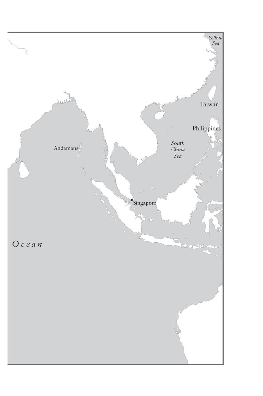
The scattered, empty islands of the Pacific meant that it became an ocean of migrants; the settled, connected shores of the Indian Ocean made it into a network of traders. Remote, widely scattered islands such as Mauritius and Reunion were discovered and settled by Europeans and those they brought with them as slaves or indentured servants long after the Polynesians had already set foot on every habitable Pacific island. Besides, the great concentration of Indian Ocean islands only begins beyond the ocean’s eastern edge, spilling into the Pacific, in the territories now known as Indonesia and Malaysia. Among other islands, the Andamans were made famous by Marco Polo and other travellers because the inhabitants were said to kill or even eat any visitors; but only one island of any great size stands off Africa, and that place, Madagascar, was partly settled by Malays or Indonesians who had travelled all the way from the edges of the Pacific.This comparison does, however, leave out of account an area within the Pacific that only gradually became an important area of maritime activity: the South China Sea, stretching from Singapore across to the Philippines and up to Taiwan, and the seas beyond, the Yellow Sea and the Japan Sea, encompassing the coasts of northern China, Korea and the Japanese archipelago. This great arc, unlike the vast tracts of Polynesia, Melanesia and Micronesia, developed close links with the Indian Ocean and can sensibly be treated as an extension of the Indian Ocean world. Nothing symbolizes these links better than the appetite of Chinese and Japanese Buddhists in the first millennium ad for Indian texts, relics and even works of art, so that a fresco painted in the Nara region of Japan in
46 THE MIDDLE OCEAN: THE INDIAN OCEAN AND ITS NEIGHBOURS ad 759 clearly portrays an Indian princess, and carries the imprint of the Hellenistic artists who, in the wake of Alexander the Great, brought Greek artistic styles to north-western India.1 The waters to the east of China remained remarkably quiet for much longer than the waters of the Indian Ocean, whose history as a thoroughfare began, in fits and starts, as Egyptians and Sumerians sent their first trading expeditions down the Red Sea and the Gulf.
All this testifies to the extraordinary vitality of the Indian Ocean since antiquity; by the first millennium the only sea where exchanges of goods and the movement of people were more intense was the much smaller and more confined Mediterranean.Historians of the Indian Ocean have in consequence tended to think of the Indian Ocean as a sort of Mediterranean, a sea defined by its edges, even if there exists no southern edge. Like the Mediterranean, it is a sea that falls neatly into two halves, with Ceylon, the modern Sri Lanka, playing the role of Sicily, a substantial island looking both ways, while southern India has something of the role of Italy, with its western and eastern flanks connected to one another by land or sea, so that these areas functioned as bridges between the trading world of the western and eastern ‘Indies’. That is a term drawn from Latin and Greek, and ultimately from Hindi, which by its very indeterminacy says something important about the vast space of the Indian Ocean; for in antiquity and the Middle Ages the term ‘Indies’ embraced not just India and Indonesia but the east coast of Africa, that is, anywhere lapped by the Indian Ocean. This later led to much confusion about where to find the mythical medieval king Prester John, a Christian prince who would come to the salvation of western Europe in the struggle against Muslim power; and it led to equal confusion when the first Gypsies to reach western Europe around 1400 talked blithely of origins in India, or maybe ‘little Egypt’, but somewhere out there, at any rate. The confusion was magnified further when the New World was defined by Columbus as the ‘Indies’, so we do not think twice about using such terms as ‘West Indian’ for inhabitants of the Caribbean, and have only recently substituted ‘Native American’ for ‘Red Indian’. Not surprisingly, some of the ocean’s historians have expressed dislike for the term ‘Indian Ocean’, which appears to privilege one part of the extensive shoreline, but this is to apply modern rather than ancient and medieval concepts of India - a small India rather than the greater Indies.2
The Indian Ocean is hard to measure.
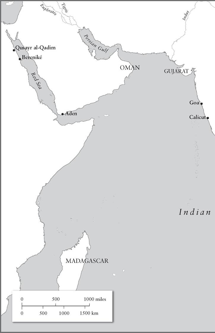
To say it covers 75,000,000 square kilometres or 27 per cent of the world’s maritime space is to assume we know where its arbitrarily drawn southern limit should lie.3 It can be defined by its historic exit points: past Aden and up the Red Sea, which acted as a bridge between the Mediterranean and the Indian Ocean;through the Strait of Malacca past Singapore into the Pacific. To these can be added, much later, with the Portuguese entry into the Indian Ocean in 1497, the Cape of Good Hope, giving access to the Atlantic. Another southern edge, the west coast of Australia, was not of much interest to anyone sailing the seas until the nineteenth century, and even then to a very limited degree. But one of the earliest and most vibrant exit points, even though it leads to rivers rather than the open sea, passes through the waters between Arabia and Iran variously known as the Persian and the Arabian Gulf.4
It seems odd to speak of ‘the slow creation’ of the Indian Ocean, as if this space had not been in existence for millions of years before sea traffic began to pass along its shores and across its open spaces. But from the perspective of maritime history the question is when the Indian Ocean began to function as a unit - in other words, when the coasts of east Africa, Arabia, India and south-east Asia began to interact across the sea, whether through migration or through trade. In addition to breaking down these shores into a series of discrete, and at times quite disconnected, coasts, attention has to focus on the two major gulfs that penetrate deep into the Middle East, the Red Sea and the Persian Gulf, channels that gave access to two of the earliest, richest and most innovative civilizations of the ancient world, those of ancient Egypt and Mesopotamia. To say that they made very profitable use of the sea routes running south-eastwards from their lands is not to say that the pharaohs or the merchants of the Sumerian and Babylonian cities made uninterrupted use of these routes; nor is it to claim that they ventured very far out into the ocean, though, as will be seen, the Sumerians did make contact by sea with another great civilization that lay to the east of Mesopotamia.
The beginnings of Indian Ocean trade were jerky; maritime ventures such as the Egyptian expeditions down the Red Sea to the ‘land of Punt’ were intermittent, and there is no evidence in the earliest documents or in the archaeological records that regular voyages took place around Arabia, linking Egyptian ports on the Red Sea to the Persian Gulf. And yet the produce of the lands along the shores of the Indian Ocean was irresistible: expensive necessities such as copper, luxury materials such as black ebony and white ivory, as well as aromatic resins such as frankincense and myrrh. Egyptians talked of the products of Punt, which they described as ‘the god’s land’, and in early Mesopotamia the route down the Persian Gulf was said to lead to the abode of the Blessed.The nearer edges of the Indian Ocean and even the Red Sea and the Persian Gulf were vaguely defined, according to mental maps on which place names moved around and seem to have indicated where particular products could be found, rather than where a destination actually lay: the
land of copper, the land of perfumes, and so on. Despite their impressive mastery of astronomy, the ancient Babylonians had no sense of the scale of the great ocean that lay beyond the Gulf. A highly schematic Babylonian world map preserved on a cuneiform tablet in the British Museum, dating from 700-500 bc, not surprisingly placed Iraq at the centre of the world, with the Bitter Sea (Persian Gulf) leading off to the south-east and a Salt Sea surrounding the landmass. The aim of the mapmaker was to illustrate Babylonian mythology rather than to guide sailors to a safe haven, and in this sense it is comparable to the equally schematic world maps of medieval Europe such as the Hereford mappamundi. But there is a sense that, even 2,000 years after the first regular voyages crept out of the Persian Gulf, knowledge of and interest in the wider expanses of the Indian Ocean had not progressed very far.
That would happen when Greek and Roman trade began to penetrate ever deeper into the ocean in search of the spices of the Indies.One famous physical feature of the Indian Ocean gives the area unity: the monsoons. They determine the sailing seasons and, more importantly, the cycle of production of the foodstuffs consumed by the inhabitants and of the goods that have for millennia been sought out along the ocean’s shores. Perhaps the most striking feature of food production linked to the monsoons is the distinction between the areas growing wheat (sometimes mixed with millet or similar grains) and those producing rice. In the regions to the west the best hope was to await winter rains, or to dig canals and irrigate the soil with the help of the great river systems - the Tigris and Euphrates in Mesopotamia, the Indus in what is now Pakistan. There, bread became ‘the staff of life’ for Arabians, Persians and north Indians. The western sector was the sector of bread. But the eastern sector, from southern India across to the paddy fields of south-east Asia, was wedded to rice in a great variety of types: husky and round, thin and polished, even (once one reached China) white, brown, pink and yellow, new and old - this was considered the tastiest type.5 Grain surpluses, in wheat or rice, underwrote the political success of the states that emerged close to the ancient and medieval Indian Ocean - whether Sumer in Iraq, far back in the third and second millennia bc, or Angkor in Cambodia in the ninth to twelfth centuries ad. With the strong economic base these surpluses provided, there was plenty of capacity for diversification into crafts and into the production and distribution of luxury foodstuffs and dyes, notably the pepper for which the Romans and their successors had such a powerful craving. Rice, the monsoon crop par excellence, could also be traded to those areas that did not produce it, or produced little of it; once the trade routes had been established, there was more to commerce across the ocean than the conveyance of aromatic spices.
The origin of the monsoons lies in the high air temperatures created in the Asian landmass during the summer; cooler air is drawn northeastwards across the ocean.
And then in winter it is much the opposite, as the landmass cools sharply but the ocean retains its warmth. So between June and October winds blow favourably for shipping bound from the south-west of the ocean towards Indonesia, even if that often means sailing through thick blankets of warm rain. On the other hand, strong winds and tempests at sea made navigation in the western Indian Ocean very hazardous in high summer, interrupting traffic to western India, and sailors had to await the slackening of the winds in late August before essaying this route, although there was a window of opportunity for the Omani dhows that had a good chance of reaching India from Arabia in May, June and July. September to May was the period of the year when sailing from Gujarat in western India to Aden proved most feasible. During the fifteenth century, vessels set out from Calicut in January, bound for Aden, and then returned in late summer or early autumn. Winter was also the ideal time to head down from Aden or Oman to the coast of east Africa, returning in April and May - a slow return, generally, as it involved sailing against the currents. Within the Red Sea one had to know that the safe period for a journey northwards lay in January and February, while those bound southwards would need to take advantage of winds that blew southwards in summer time. So, both in the ocean at large and in its subsidiary seas, it was vital to understand how and when the winds shifted from south to north.Without knowledge of the winds, medieval Arabic writers insisted, a captain would prove himself ‘an ignorant and inexperienced adventurer’. From December onwards the winds come from the north and reach as far as Madagascar. By spring, vast quantities of water have been dumped on India and on the southern tip of Arabia (creating an extraordinarily fertile zone in western Oman). Even so, the changes in the winds were predictable rather than certain, and a wise captain knew that helping winds could blow earlier in the season than expected, or that the monsoons could vary in ferocity from year to year. The captain would also take into account the seasonal changes in the currents, though these were heavily influenced by the monsoon winds: in the Red Sea the summer current ran helpfully from north to south, but in winter the movement of water was more complex, and navigation along this sea, already littered with reefs, could be quite perilous; the Persian Gulf followed a similar pattern in summer but thankfully made an uncomplicated reverse in winter.6
These characteristics of the Indian Ocean affected the movement of people and the conduct of trade to a much greater degree than one would find in the narrow space of the Mediterranean, where it was possible to challenge the winds and currents, even out of season. The monsoon cycle imposed on travellers a long stay in port as they awaited the turning of the winds. Differences in the wind direction and currents in the western and eastern sectors of the Indian Ocean meant that sea journeys generally had to be conducted in stages. This was even true in the confined space of the Red Sea, where merchants had to await suitable winds in way stations along the coast such as Berenike and Qusayr al-Qadim, which developed into quite substantial towns servicing the trade routes in the Roman and medieval periods. It is therefore no surprise that in the medieval period, at any rate, the spice route was cut into segments and different stretches were handled by merchants and sailors of different origins - Malays, Tamils, Gujaratis, Persians, Arabs of Arabia, Jews or Copts or Arabs of Egypt. Southern India was the limit of penetration of so-called Roman merchants, that is, businessmen seeking to pipe spices and perfumes into the Mediterranean via the Red Sea. Only with the coming of the Portuguese did a sailing nation appear that sought to span all the great trade routes of this ocean, but they were as confined by the monsoon season as anyone when trading to and beyond Calicut and Goa.
II
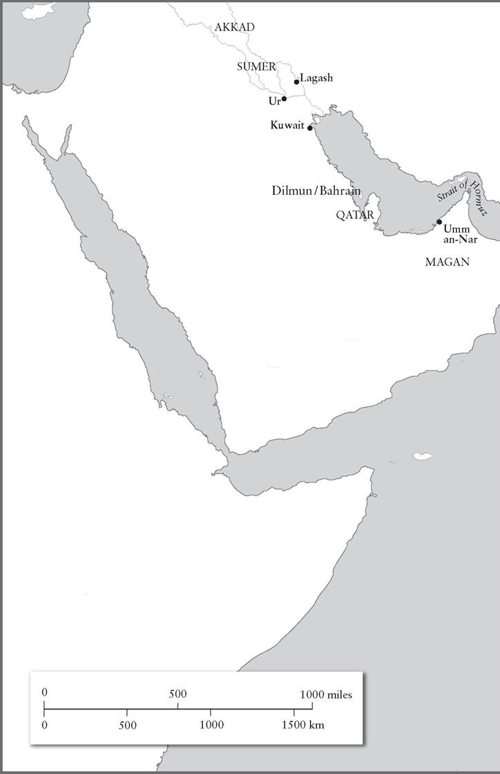
The Persian or Arabian Gulf is a small area into which many contrasts have been packed: its north-eastern shore leads steeply upwards to the mountains of Persia, offering few good harbours; its south-eastern shores are dry, sandy spaces, mainly flat but afflicted by the intense heat of Arabia and the high humidity of an area close to the warm sea; its northern tip is waterlogged, filled with the silt of the Tigris and Euphrates that has carried the shoreline ever southwards and gives access to lands rich in wheat, themselves contained by desert and upland. After about 4000 bc a relatively benign phase came to an end which had seen moderate rainfall in Arabia, and increasing aridification set in - this, indeed, provided a stimulus to trade, as self-sufficiency broke down. Another major change occurred with a fall in sea levels of about two metres by around 6000 bc, so that archaeological sites that would have been originally on the shoreline now stand a little higher up, a short way inland.7 Within the Gulf, islands and peninsulas have offered stopping points for travellers, notably at Bahrain, Qatar and Umm an-Nar (near Abu Dhabi); and then, beyond the narrowing of the sea at the Strait of Hormuz, backed by the mountains of Oman, there is access to the ocean itself, and the chance to make way along the coasts of what are now Iran and Pakistan as far as the opening of other rivers: the Indus and the many river systems of north-west India. These different environments were not generally self-sufficient and depended upon exchange; date palms played a particularly important part in the networks of maritime trade that emerged as early as the sixth millennium bc.
At this time a relatively advanced culture developed in southern Iraq that has been given the name Ubaid; by 4500 bc it came to be characterized by temples, palaces and the beginning of towns.8 The domestication of animals and the cultivation of the soil, already under way several thousand years before, produced, in several corners of Asia and the Middle East, hierarchical and increasingly sophisticated societies, the ancestors of those that would create the massive cities and spectacular artworks of Mesopotamia, Egypt, China and (though rather later) the Indus Valley. It is impossible to underestimate the importance in these societies of the great rivers, not so much as means of communication, though that came later, but as sources of fresh water for agriculture. However, knowledge of Ubaid is still very fragmentary. Over so many centuries there must have been enormous transformations, and identifying them is rendered no easier by the sparse and often inconsistent dating that has been suggested by archaeologists.
The basis of the wealth of the Ubaid culture seems to have been mastery over agricultural produce and the possession of flocks, used not just as food but as the foundation of leather and cloth industries, though inevitably the hard evidence consists mainly of Ubaid pottery, with its distinctive and often elegant linear decoration. Who controlled this proto-urban society cannot be said with any certainty; but the occasional presence of traders can be assumed with some confidence. This is because Ubaid pottery turns up regularly on sites away from southern Iraq, in Saudi Arabia, in Oman and on the other side of the Gulf in Iran.9 Shards of very early Ubaid pottery, with a green tinge and purple decoration, are definitely of Mesopotamian origin. Yet other Ubaid goods, such as the typical southern Mesopotamian figurines, have not appeared on sites along the Arabian coast, leading archaeologists to conclude that the pottery fragments are evidence for occasional visits by merchants from Iraq, but not proof that a fully fledged trading network had come into existence. The people of the coast were still limited in their technology to fairly standard stone tools, and did not have the wherewithal, as far as one can tell, to launch expeditions across the water; nor were their own settlements long-lasting towns in germ, but rather villages that came and went off the map.10 As early as the late sixth millennium, dates, apparently traded, were arriving in Kuwait and on the island of Dalma off Abu Dhabi, for their carbonized remains have been identified by archaeologists; then as now the date was an everyday stand-by in the daily diet, a reliable source of energy and a quick stomach-filler.
This was not just a simple route up and down the Gulf, linked to the settlements of Ubaid. Beads of carnelian, a semi-precious stone from Iran or Pakistan, have been found in Qatar, as also in Iraq.11 Plenty of boats were being built along the shores of the Gulf in the fifth, fourth and third millennia bc. Around 5000 bc, to judge from impressions left in fragments of bitumen found at as-Sabiyah in Kuwait, boats were constructed out of reed bundles covered with tar. There are traces of barnacles, a sign that these boats set out across saltwater.12 Further evidence survives in the form of a pottery model of a ship and a small painted disc carrying the image of a sailing vessel. Tunny-fishing was certainly one maritime activity of the inhabitants of early Bahrain, to judge from the fish bones found there by archaeologists. The finds of Ubaid pottery are neatly spread out along the Arabian coast, which suggests that boats were jumping from one waterhole to another as they wended their way down the Gulf.13
It would be hard to insist that this water traffic had yet become the economic mainstay of Ubaid Iraq, however important it was to the developing communities of Bahrain and other Gulf stopping places. Ubaid enjoyed increasingly intense land traffic towards Syria in the west, Afghanistan in the east and central Asia in the north; southern Arabia would become more and more important in later phases, when the search for metal ores was under way. The maritime inhabitants of the Persian Gulf lagged behind Ubaid in technological sophistication, living in barasti huts made of wooden poles and palm leaves, while the Mesopotamians increasingly accustomed themselves to stone-walled houses.14 Fourth-millennium Ubaidi traders came to collect dates from the Arabian coast and delivered grain or cloth in return as well as acquiring Gulf pearls, in demand in the increasingly sophisticated towns of Iraq. Pearl-fishing has been a mainstay of economic life in the Gulf over many millennia, and references in the earliest cuneiform tablets from Mesopotamia to the importation of ‘fisheyes’, meaning pearls, leads one to suspect that this trade goes back very far in time; pearls, given their organic origin, tend to survive much less well on archaeological sites than precious stones made out of minerals.
The traders also brought down the Gulf that upmarket cutting material of volcanic origin, obsidian, which came all the way from Anatolia by way of Mesopotamia. Rather than imagining that somewhere in the Caucasus beside Lake Van a merchant had thought of sending this item to a distant village on a remote sea, we should assume that this was handed from person to person, taking many years or even generations to end up where it did.15 This may all look rather unpromising. What product or process could create firmer links between the ever more magnificent civilization of ancient Mesopotamia and a sea bordered by sand dunes and rough mountains? One answer is that those mountains contained a particular mineral much in demand in the luxurious cities of early Bronze Age Mesopotamia.
Ill
The discovery of Sumerian civilization came as a great surprise to the archaeologists who painstakingly excavated and reconstructed the cities of a much more familiar group of civilizations in Mesopotamia that were mentioned in the Bible. It was known that the early Babylonian kings, speakers of the Semitic language known as Akkadian, called themselves ‘kings of Sumer and Akkad’. But where and what was Sumer? The unearthing of the lowest levels at Ur and other cities brought, particularly to the British Museum, astonishing treasures 2,000 years older than the enormous Assyrian carvings and reliefs of around 700 bc that were also carted to London. The Assyrians and Babylonians proved to be the heirs to a very much older civilization of the third millennium bc that did not make use of a Semitic language, as they did, but that wrote in a similar cuneiform script; and this could be deciphered once the sound values of the Akkadian of Babylonia were known, as the enormously plentiful Akkadian tablets that still survive helpfully include bilingual texts and dictionaries of Sumerian.16 Sumerian literature exerted a fascination for Babylonians long after Sumer was buried beneath the rubble, rather as knowledge of ancient Rome and its language has persisted over the centuries in Europe and beyond. Sumerian myths were rewritten for Babylonian audiences, notably the series of tales about Gilgamesh, king of Uruk. Indeed, it was the Sumerians who as far as we know invented the first coherent, standardized system of writing, even if other civilizations such as that of Egypt preferred not to use the clay tablets impressed with a dense mass of often microscopic letters that came to be favoured in Mesopotamia. But these tablets make up in durability (once baked) for their apparent illegibility.
It is extraordinary, at such a remote period in the past, that we can make use of all three building blocks out of which the early history of mankind has to be constructed, rather than just one of them: works of literature; archaeological finds; and the day-to-day documents left by
56 THE MIDDLE OCEAN: THE INDIAN OCEAN AND ITS NEIGHBOURS business houses in the third millennium bc. Taken together, they show how the Gulf emerged as one of the great maritime thoroughfares of that millennium, and how it experienced decline. They help us understand not just the economic foundations of the first true civilization in the world, Sumer, in southern Iraq, but its connections to other great civilizations, especially that of the Indus. They provide the first glimpses of communities of merchants and their hangers-on who settled in ports en route from India to Sumer and left behind their detritus - seals, pottery, necklaces. The exotic lands of Dilmun and Meluhha emerge from a fog, and with increasing confidence they can be located on the mental map of the Sumerians. But even citing these names raises problems. Like the term ‘Indies’, the names Dilmun and Meluhha meant different things at different times, and the assumed location of Meluhha eventually shifted from Asia to east Africa, long after the Sumerians had been conquered by the Babylonians and Assyrians. And as for Dilmun, it entered literature as a never-never land, a paradise where resided Ziusudra, known to the Babylonians as Uti-napishtim; he was the survivor of the Great Deluge that swept away the rest of mankind in a version of the story of the Flood that in many precise details, such as the sending out of birds to test the waters, anticipates the account of Noah in the book of Genesis. In the Sumerian Flood narrative, Ziusudra was sent by the gods to Dilmun, which was to be found ‘where the sun rises’, and was granted the eternal life that others, such as the hero Gilgamesh, sought but did not find. Bilgames, as the Sumerians called that hero, even sought out Ziusudra in ‘the Land of the Living’; but in the end Bilgames too was fated to follow his great friend Enkidu down into the gloomy Netherworld where disconsolate souls flitted about but there was nothing to enjoy.17
Dilmun appears again and again in the cuneiform tablets that have been excavated in the Sumerian cities.18 The one Sumerian word to have reached modern English and many other languages is ‘abyss’, recalling the Sumerian abzu, the great freshwater deeps on which the world was said to float, with the seabed forming a barrier between saltwater and the waters of the abzu which welled up and fed the springs of life on earth. The god of the abzu was Enki, who was both the patron of the oldest of the Sumerian cities, Eridu, and a frequent visitor to Dilmun. And one can see why he would wish to go there and escape the chatter of humans, which had driven the gods to such distraction that they unleashed the flood waters on the earth, for, as one tablet proclaims:
The land of Dilmun is holy, the land of Dilmun is pure,
The land of Dilmun is clean, the land of Dilmun is holy...
In Dilmun the raven utters no cry,
The wild hen utters not the cry of the wild hen,
The lion kills not,
The wolf snatches not the lamb,
Unknown is the kid-devouring wild dog,
Unknown is the grain-devouring boar.19
There, there is neither sickness nor old age. Indeed, such is the store of plenty that Dilmun has become the ‘house of the docks and quays of the land’, in other words a rich centre of trade.20 Dilmun slid from being an Eden on earth to a real place with ships, merchants and treasures piled up in its storehouses. The god Enki blessed Dilmun and listed the places with which it would trade in luxury products: gold from a place called Harali, lapis lazuli from Tukrish (presumably Afghanistan, the great source of the vivid blue mineral), carnelian and fine wood from Meluhha, copper from Magan, ebony from the ‘Sea Land’, but also grain, sesame oil, fine garments from Ur in Mesopotamia, handled by skilled Sumerian sailors:
May the wide sea bring you its abundance.
The city - its dwellings are good dwellings, Dilmun - its dwellings are good dwellings, Its barley is very small barley, Its dates are very large dates.21
If, as will be seen, Meluhha was a major neighbouring civilization and Magan was a land rich in copper, then what was being portrayed here was a great trading city blessed by a great god that lay somewhere towards or within the Indian Ocean, an entrepot intermediate between Sumer, Magan and Meluhha; the task is to see if anything in the archaeological record proves Dilmun was not simply a fantasy of Sumerian poets.
The clay tablets are the place to begin. Official documents - religious litanies, royal inscriptions, and so on - enumerated products such as black wood from Meluhha, presumably ebony, and a table and chair from Magan, so the places mentioned by the Sumerian poets were real ones. There are several references to boats of Dilmun, Magan and Meluhha; they are known to have reached Akkad in the reign of King Sargon the Great, who was probably the most dynamic ruler of Sumer and Akkad, and who lived in the twenty-third or twenty-second century bc: ‘at the wharf of Agade he made moor ships from Meluhha, ships from Magan and ships from Dilmun... 5,400 soldiers ate daily in his palace’.22 This hardly comes as a surprise: supposedly the son of a gardener who became
58 THE MIDDLE OCEAN: THE INDIAN OCEAN AND ITS NEIGHBOURS royal cupbearer and eventually usurped the throne, Sargon, like many a usurper, assumed that magnificence and luxury would cast a veil over his controversial origins and path to power. After Sargon’s reign, there was an interruption in ties to Magan, for some mysterious reason, and one of his successors, Ur-Nammu (2112-2095 bc) displayed special pride in restoring this contact, for he had four cones made out of clay and inscribed with the same inscription in honour of the god Nanna:
For Nanna, the chief son of Enlil, his lord, Ur-Nammu, the mighty male, the king of Ur, the king of Sumer and Akkad, the king who built the temple of Nanna, caused the former state of affairs to reappear, at the edge of the sea in the customs house trade was [gap in the inscriptions]... Ur-Nammu restored the Magan trade [literally : boat] into Nanna’s hands.23
These expeditions into the still uncertain waters of the Persian Gulf were, then, dedicated to the gods, whose protection was sought and whose temples benefited from the copper and luxury goods brought from Dil- mun, Magan and beyond.
The best evidence for the reality of Dilmun lies in what would be regarded as quite humdrum documents about merchants and their importexport businesses, were they not so exceptionally old. Lu-Enlilla, for instance, was a garasa-abba or seafaring merchant from Ur, one of the greatest Sumerian cities, who traded on behalf of the Temple of Nanna and was commissioned by its administrator, a certain Daia, to take fine cloths and wool on a trading expedition; he was to exchange these goods for copper of Magan. Copper was the great desideratum: Sumer had emerged at a time when copper and, subsequently, copper smelted with tin to make bronze, was required in ever vaster quantities not just to forge strong weapons and tools but to create beautiful objects - figurines, panels, bowls. Sumer was rich in the produce of the soil and of its flocks of sheep and cattle, but poor in metals, robust timber and good quality stone. The copper-bearing mountains of Oman were the place to which to turn for metal, and there is no doubt that Magan corresponds to what is now the Omani peninsula (now partly under the rule of the sultan of Oman and partly under the rule of the sheikhs of the UAE).24 Proof that the copper came from there lies in the small natural nickel content of Omani copper, which is closer to the nickel content found in copper objects from Sumer than it is to the copper of lands to the north. Copper from the mountains to the north of Mesopotamia was also more expensive and, given the vast quantities that were traded, was more difficult to transport than the seaborne copper of Magan. Oddly, Magan bought barley from Ur but provided Lu-Enlilla with onions, which were plentiful enough in
Mesopotamia, so maybe the sailors on board a ship bound from there had overstocked their larder with them and Lu-Enlilla simply had to put up with that.25 Meanwhile life in Magan improved; settlements became more permanent, stone towers were built, as well as monumental tombs. This was still a dispersed society, and nothing remotely comparable to the great cities of Sumer emerged, but merchants in search of copper (of which fragments survive in local graves) had given a stimulus to an area that in earlier centuries had been a deserted backwater.26
The sea was becoming more important as Ur and its neighbours became greater and greater centres of consumption. Difficult routes across the mountains of Afghanistan could be avoided by taking the sea route to India, where access could be gained to the increasingly powerful cities of the Indus Valley. A gift to the goddess Ningal at Ur included two shekels’ weight of lapis lazuli, carnelian, other prized stones and ‘fish-eyes’ (pearls); these goods had arrived from Dilmun, ‘the persons having gone there by themselves from the month Nissannu till the month Addaru’. The names of these months were eventually passed all the way down to the Hebrew calendar as Nisan and Adar, and, bearing in mind the astronomical sophistication of the peoples of ancient Mesopotamia, we can be sure that this means they were absent for eleven months. The gifts had arrived from Dilmun, but they had originated in a scattering of places - the presence of ivory among items listed on some of these tablets suggests links to India, a land of elephants, and its presence was not incidental, for ivory objects were lovingly carved in Ur or were imported ready-carved, like some painted ivory figures of birds, brought from Meluhha, as was much of the carnelian that was so cherished in Sumer. Sometimes, it appears, natives of Dilmun came with these goods; and sometimes men of Ur, such as Lu-Enlilla, set out for Dilmun and carried on their trade there. Some Ur merchants did so as agents of a temple; but, increasingly, others worked on their own.27 Loans at interest, business partnerships, trading contracts assigning risk, and other indications of a commercial economy with many of the attributes of mercantile capitalism abound, for the first capitalists on record were Sumerian merchants long ago in the third millennium bc:
Lu-Meslamtae and Nigsisanabsa have borrowed from Ur-Nimmar 2 minas of silver, 5 kur of sesame oil, 30 garments, for an expedition to Dilmun to buy copper there. On the safe return of the expedition, the creditor will not make a claim for any commercial losses. The debtors have mutually agreed to satisfy Ur-Nimmar with 4 minas of copper for each shekel of silver as a just price; this they have sworn before the king.28
But for the use of weighed silver in place of coin (not such a great difference, all told), and the names, this could almost be a commercial document from Barcelona over thirty centuries later.
The contract just cited forms part of the business correspondence of Ea-nasir, a wealthy merchant of Ur, whose house was identified by Sir Leonard Woolley during his triumphant excavation of Ur of the Chaldees in the 1920s and 1930s; it was not a particularly large house, and consisted of five rooms around a main courtyard, though a couple of rooms had been ceded to a neighbour. He lived around 1800 bc, at the end of the Sumerian ascendancy and at a time, as will become clear, when trade to India had contracted. But he was still a wealthy man. His speciality was copper, which was delivered in ingots, and he apparently supplied the royal palace. He was surely one of the most prominent businessmen of his day, maybe a little unscrupulous, but looking at his wealth it is impossible not to be impressed: one of his shipments weighed eighteen and a half metric tons, of which nearly one third belonged to him.29 The character of trade had changed somewhat in the century since Lu-Enlilla had lived, and the temples of Ur were no longer (so far as we know) heavily involved in expeditions down the Persian Gulf; this was business conducted by private merchants, and they preferred to pay for their goods in silver, weighed by the shekel, rather than in textiles, as had been the case with Lu-Enlilla. Probably many of the textiles Lu-Enlilla had sent to Dilmun and beyond were woven in temple workshops by female slaves attached to the temple itself. Silver, on the other hand, suited the needs of mobile merchants who constantly and energetically bought and sold, and traded on the open market in Ur.
Far from being a dry enumeration of imports and exports, Ea-nasir’s private archive conjures up the passionate disputes that were bound to arise about the quality of goods and the obligations to fulfil a contract:
Speak to Ea-nasir; thus says Nanni: now when you had come you spoke saying thus: ‘I will give good ingots to Gimil-Sin’; this you said to me when you had come, but you have not done it; you have offered bad ingots to my messenger, saying: ‘If you will take it, take it, if you will not take it, go away.’ Who am I that you are treating me in this manner - treating me with such contempt? And between gentlemen such as we are!’... Who is there among the Dilmun traders who has acted against me in this way?30
The word translated as ‘gentleman’ is a technical term for a citizen of a very respectable social position, and ‘gentlemen’ were bound by a code of honour to which they swore their adherence in the temple of the sun god, Shamash; it was this divinely guaranteed contract that he was being accused of ignoring.31 This is only part of a longer complaint, and just one of several that Ea-nasir filed away. Even though many of his partners were perfectly satisfied with his conduct, he has been described as a difficult, perhaps sleazy, businessman. This may be unfair; he is far more likely to have preserved documents about transactions out of which claims could arise than others, perhaps the vast majority, that could safely be discarded once everyone was quit of their profit.
IV
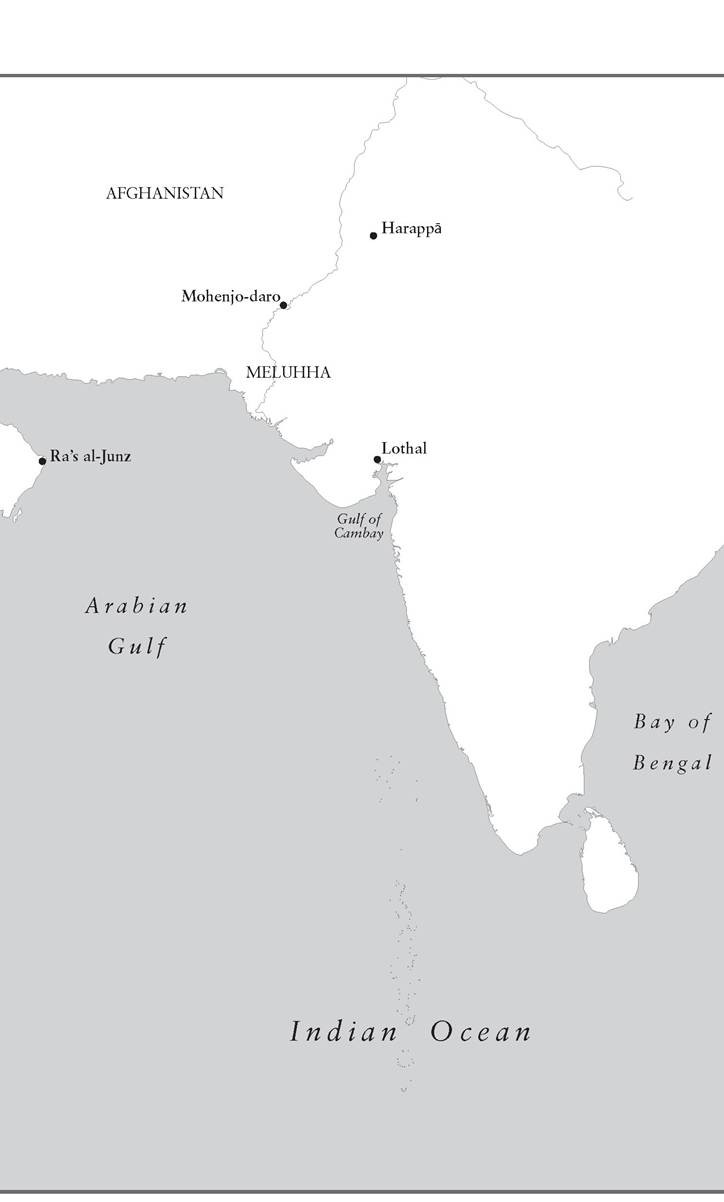
Magan, then, lay close to the exit from the Persian Gulf, reaching up to the tip of the Musandam peninsula, where Oman almost brushes Iran. For many sailors, Magan must have meant the island of Umm an-Nar near Abu Dhabi, a significant settlement where plenty of Sumerian pottery has been found and where copper from the Omani mines reached the Persian Gulf; Umm an-Nar was a sort of storehouse for goods being despatched towards Iraq.32 The massive reconstructed tomb at Mleiha in the Emirate of Sharjah (UAE), a product of the Umm an-Nar culture, is 13.85 metres across.33 However, the term ‘Magan’ was also applied to the Oman peninsula. As Harriet Crawford has observed, ‘the ancient scribes seem to have had a rather elastic and foggy concept of location.’34 But where was Meluhha? Everything suggests that it was a wealthy and desirable trading partner for Sumer. The creation of a sea link between Sumer and another centre of high civilization has special importance in the maritime history of humanity, as one of the first moments, perhaps the first moment, when civilizations that had developed independently to a comparable cultural level entered into dialogue with one another across the sea. Once it has been located it will be possible to return to the question of where Dilmun was to be found, whether it was a specific place or a broader region. Sumerian documents often listed Dilmun, Magan and Meluhha together, because they obviously lay on the same sea route, with Meluhha at the end. Since ivory was one of the most precious exports from Meluhha, the choice is narrowed down to the coast of east Africa or that of India, the two areas from which we could expect elephant ivory to be exported; and it has been seen that Indian goods did reach Sumer.
In much later centuries, when the Assyrians dominated Mesopotamia during the early first millennium bc, the name of Meluhha became attached to parts of east Africa; but that certainly does not mean it was always identified with the area. In the first place, the route out of the Persian Gulf tends eastwards, to lands rich in carnelian as well as ivory; there is a short, clear run from the Strait of Hormuz to the coast of Pakistan. Indeed, the relationship between that coast and Oman has been so close that from the eighteenth century to the middle of the twentieth century the sultans of Oman possessed an outpost on the coast of Pakistan, at Gwadar, 240 miles from Oman proper. Moreover, if ships that left the Persian Gulf then turned south and west, coasting along the shores of Yemen past Aden and maybe as far as east Africa, we should expect evidence of Sumerian contacts in Yemen too, but there is none. Nor is there evidence that the inhabitants of what are now Yemen, Somalia and neighbouring regions were able to launch their own trading fleets, whereas this was certainly true of the Meluhhans. Ships from Meluhha and Magan are known to have reached Sumer in the days of King Sargon around 2300 bc and to have docked at his capital, Akkad, where lived ‘Su-i lisu the Meluhha interpreter’. There were enough Meluhhans around Lagash in the century before 2000 bc to create a ‘village of Meluhha’, and they had a garden and fields producing barley, so Meluhhan migrants were familiar in Mesopotamia at this time.35 Looking eastwards, the journey along the shores of Iran and Baluchistan to the mouth of the Indus was far less challenging than that to Africa, and perfectly manageable under a captain who understood the monsoon seasons.36
It is not beyond credibility that ‘Magan’ actually meant ‘copper’ (rather as Cyprus, Kupros, did in Greek) and that ‘Meluhha’ meant ‘ivory’, in the language of proto-historic India. Or Meluhha may originally have meant ‘the place across the sea’, rather like the medieval term Outremer that Europeans eventually attached to the crusader kingdom of Jerusalem, but could have meant anywhere across the sea before becoming attached to a particular place; this might be deduced from the Arabic term milaha, possibly derived from ‘Meluhha’, which was used in the early Middle Ages to mean navigation, seafaring or seamanship.37 Afghan lapis lazuli could be obtained from Meluhha; this would have been carried down the Indus Valley to ports where Sumerian traders were making their purchases. The area also produced fine woods, including a ‘black wood’ that must be ebony, and sometimes wooden objects decorated with gold were brought from there, another sign that Meluhha was no backwater. Finally, and conclusively, inscribed Indian seals have occasionally been found on Sumerian sites and in reasonable quantity in the Persian Gulf, so there can be no doubt that contact existed between Sumer and the Indus Valley. Moreover, Indus pottery has been found at Abu Dhabi.38
The Indus Valley civilization remains the least known of the great Bronze Age civilizations, for such evidence as there is often remains impenetrable - there are inscriptions in a script that cannot be read and a language that cannot be guessed at, and there is little that can be said about the social and political organization of a culture whose impressive cities stare blankly at the excavator. For the Indus Valley appears to have been dominated in the second half of the third millennium bc by two massive and tightly planned cities, very similar in layout and construction, Harappa and Mohenjo-daro, though these are only their modern names. They lie a full 350 miles apart, and the more southerly city, Mohenjo-daro, stands very roughly 200 miles up the Indus River.39 These were not, then, cities that had immediate access to the sea, though from Mohenjo-daro it is easy to imagine craft reaching the Indian Ocean, and the Indus civilization possessed many dozens of towns and ports along the ocean shore, in the general area of Karachi, ruling over as much as 800 miles or 1,300 kilometres of coastline, far beyond the Indus estuary. One of the most important harbours lay at Lothal, in the Gulf of Cambay (north-west India), which gave access both to the local river system and to the open sea, and which offered the facilities ships would require at the end of the long journey from the Persian Gulf. Lothal possessed a substantial dockyard and several anchors have been found there. It traded in several directions, for there were contacts with the Neolithic peoples living further south along the west coast of India as well as with the Persian Gulf.40
So much attention has concentrated on the mystery of how the two highly organized mega-cities came to be built along the Indus river system that rather little interest has been shown in other places, and even the assumption that these were the twin capitals of a single empire is pleasant speculation. Rigid central control was in place, for, as the archaeologist Stuart Piggott observed, the size of bricks used to build the two great cities, the highly standardized pottery, and the weights and measures show ‘absolute uniformity’: ‘there is a terrible efficiency about the Harappa civilization which recalls all the worst of Rome’, while he also observed ‘an isolation and stagnation hard to parallel in any known civilization of the Old World’. Over several hundred years during the second half of the third millennium bc not much changed.41 Although it has proved hard to identify any grand palaces or temples, this was a highly stratified society in which labour gangs were set to work pounding grain into flour. It is assumed that the major rural activity, apart from food production, was the growing of cotton, which is a convenient argument, as this is a product that leaves little residue archaeologically; there is no obvious mention of cotton in Sumerian documents that mention Meluhha, and the Sumerians sent their own textiles to Meluhha, whose main attraction was the luxury items, semi-precious stones, ivory and fine woods, mentioned already. Very occasionally one of the distinctive Sumerian cylinder seals, carved
64 THE MIDDLE OCEAN: THE INDIAN OCEAN AND ITS NEIGHBOURS to be rolled across clay, reached Mohenjo-daro, though Sumerian items rarely appear on Indus sites, even though Indus products such as carnelian beads appear quite often in Sumer.42 A piece from an Omani vase also reached Mohenjo-daro, no doubt by sea and river. The best place to look for signs of contact is the port of Lothal, and, to be sure, gold pendants of Sumerian origin and (possibly) Mesopotamian pottery have been found in a merchant’s house there, as has a clay model of a boat. A circular seal found at Lothal, showing goats or gazelles and a dragon, bears close resemblance to circular Sumerian seals.43
Seals, however, provide the best evidence for contact the other way, from the Indus Valley towards Sumer. It is not just that seals, being made of stone, survive well; they were also used by government officials, priests, merchants and anyone else who wished to set his seal, literally, on property, and that could include goods sent by ship to foreign ports; they were functional, but they were also declarations of identity, and provided vehicles for some of our earliest written texts. The Indus seals are quite distinctive. Rather than being rolled on clay they were used as stamps, so they are flat and square; they generally portray local animals - tigers, humped oxen (zebu), elephants - and they often carry inscriptions in a distinctive linear script very different to Sumerian cuneiform.44 So if these seals turn up in the Persian Gulf in reasonable quantity, we have evidence of visits by Indian travellers to the area, evidence, in other words, of merchants passing between Meluhha and Sumer. And they have indeed been found in the ruins of major cities such as Lagash and Ur, sometimes showing the sorts of animals familiar from Indus seals, sometimes also containing a few letters in the Indus script. One seal thought to have been found in Iraq portrays a rhinoceros, which never appears in Sumerian art, for the animal was unknown in Mesopotamia. This seal has some Sumerian characteristics as well, such as its shape, and it may provide evidence for Indians settled in the Sumerian lands, who have already been encountered at Lagash; but maybe a better explanation, more in accord with what we know from the Persian Gulf, is that it originated among the mixed settlements to which it is now time to turn.45
V
Having identified Magan and Meluhha with reasonable confidence, we are left with the location of Dilmun. This was another place that wandered around the Babylonian map, or rather acquired several identities: Dilmun the abode of the Blessed; Dilmun as a region; Dilmun as a specific place.
The merchants Lu-Enlilla and Ea-nasir clearly knew what they meant when they talked of Dilmun: for them, it was a place where one could buy copper and other goods, and it had its own community of traders. What began as a general term for (most likely) the Persian Gulf roadsteads that ran all the way down the Arabian shores from Kuwait to the tip of Oman came to mean one place in particular; the term may originally have signified simply ‘lands to the south’.46 Archaeologists have identified where that was, and where its outstations on the route to Magan were as well, notably Umm an-Nar, which has been mentioned already. The discovery of Dilmun was the work of two scholars from a not particularly prominent Danish museum in Aarhus, Geoffrey Bibby and P. V. Glob, later renowned for his book The Bog People, dealing with the very different topic of the prehistoric victims of human sacrifice found almost perfectly preserved in Danish bogs. Indeed, as in Denmark, the issue was bodies, or rather the 100,000 burial mounds visible in Bahrain and assumed (though this was exaggeration) all to date to some prehistoric era. Glob and Bibby questioned the easy assumption that Bahrain had been created as a vast isle of the dead, a cemetery island, which might, after a fashion, fit with the idea of Dilmun being located there, as a holy island and the abode of the Blessed.47 According to one tablet King Sargon of Akkad had conquered Dilmun, which lay in the ‘Lower Sea’, that is, the Persian Gulf. About 1,600 years later, in the eighth century bc, a warlike king of Assyria, also named Sargon, sent his armies as far as Dilmun, this time said to lie on the ‘Bitter Sea’ and to include an island; its king was Uperi, ‘who lives like a fish’ out in the sea.48 Dilmun could not, then, be very far from Sumer, and the island of Bahrain was an obvious candidate for its location. The connection went back far in time: around 2520 bc King Ur-Nanse, ruler of the Sumerian city of Lagash, asserted that ‘ships of Dilmun, from the foreign lands, brought me wood as tribute’. This visit to the king of Lagash fits neatly with archaeological evidence that settlement on Bahrain became denser around the middle of the third millennium bc.49 The coast of Arabia was an unlikely source of wood for the king of Lagash, and the wood must have been brought to Dilmun from further afield - from Iran or India.50
Bibby’s team unquestionably made great progress in identifying key sites on Bahrain and then further afield, notably in Qatar and off Abu Dhabi, and even some way into Saudi Arabia; but, precisely because they tried to cover so much ground, they never (to pursue the pun) dug deeply enough into the history of any of these regions. Still, the importance of Bahrain and its identity as the major centre of Dilmun became clear as more and more sites along the Arabian coast were identified. Bibby and Glob uncovered city walls and streets at Qala’at al-Bahrain (Bahrain fort) on the northern tip of Bahrain; but at Barbar a few miles away they made their most outstanding single discovery: a temple of the late third millennium bc, containing a well, for one of the secrets of Bahrain was the availability of sweet water rising, as the Sumerians would have said, from the abyss of abzu.5i The motives for creating a town on Bahrain island are thus not hard to deduce - and as well as water there were abundant supplies of fish, with 700 edible species swimming around the Gulf in modern times, so that fish remains a prominent part of the diet in the Gulf states. It was no different in the Bronze Age: 60 per cent of the bones found at Qala’at al-Bahrain were of fish, though the inhabitants ate a variety of meats as well, even including mongoose, which is not native and must have been brought from India; they also imported dairy goods and cereals from Mesopotamia, so they had quite a varied diet.52
One day in Bahrain a workman in Bibby’s team found a distinctive round stamp seal made of soapstone and decorated with two human figures; and more seals turned up in the well of the great temple. As he smoked his pipe, Bibby wondered whether round stamp seals, thirteen of which had been found at Ur and three in Mohenjo-daro, made of steatite and even (at Ur) occasionally adorned with Indus script, might be the product of a place halfway between the two great cities, Bahrain/Dilmun, no less.53 These seals are (like Dilmun itself) intermediate between Sumerian and Indus styles, their patterns matching those of neither grand civilization, but more a melange of the two to which some individuality had been added, as in the case of a seal showing four stylized heads of gazelles arranged in the shape of a cross - roast wild gazelle was a local delicacy, to judge from the animal bones that have been found in Bahrain. As more seals have come to light, it has been found that around one third carry signs from the Indus Valley writing system, but - before anyone jumps to the conclusion that the Dilmunites conversed in Indus-speak - the letters are combined in ways not found on inscriptions from the Indus Valley itself.54 Further weighty evidence of the Indus Valley connection came from stone globes and cubes used to weigh goods; Bibby was excited to find that these followed the Indus Valley system of weights and measures and not that of the Sumerians, but the Dilmunites also used Mesopotamian weights, which came to light later.55 This apparent confusion of weights neatly brings out the role of Dilmun as an intermediary between the cities of Sumer and those of the Indus, a place where goods were exchanged and where merchants both from Sumer, such as Ea-nasir and his agents, and from India congregated and did business together.56
Dilmun, then, was both a town that serviced maritime trade between Mesopotamia and the Indus Valley and the capital of a region dotted with other coastal or island settlements that must have functioned as safe harbours for shipping sailing up and down the Gulf. It was a place where merchants could hang around doing business all year round - between the months of Nissannu and Addaru, to cite again one of the Sumerian tablets. Whether its population was an ethnic mix of Indians and Sumerians or consisted to a large degree of other people is simply unknown, but it makes sense, bearing in mind the seals, to assume that there was a large Indian settlement there. Over the many centuries of its existence, this no doubt became an integral part of local society, as ‘native’ as anyone else (indeed, it is a striking feature of several of the Gulf states today that a massive proportion of the population hails from India and Pakistan). However, the political life of Dilmun cannot be grasped, beyond the sense that it was a well-ordered place. Dilmun had tax collectors, a not always welcome sign of systematic central management. Population was rising in the region as a whole, which was good for the tax collectors, but this also suggests that Dilmun acted as a magnet for settlers and stimulated production up and down the coast from Bahrain.57 Further down the coast, in Oman, society remained more obviously tribal and mobile, and settlements came and went. We should thus think of Dilmun as a small trading city with offshoots along the western coast of the Persian Gulf, as far south as Umm an-Nar, which gave access to the copper of Magan.
Sometimes it is the tiniest and humblest archaeological discoveries that reveal the most astonishing results. This has been particularly true of evidence for the types of ships these merchants would have used. A good point to begin is the description of the boat Ziusudra or Atrahasis built during the great flood that destroyed the rest of mankind and that was described on the Sumerian and Babylonian tablets (and later in the book of Genesis). Here, as a newly discovered tablet reveals, the boat was supposedly a gigantic version of a round hide-covered boat; the hides were plastered with bitumen and animal fat on to a frame made of miles and miles of wickerwork, within which a wooden t hree-storey structure housed the animals and the hero and his family.58 Round, keel-less hide boats were well suited to floating downstream, with the help of a couple of large paddles, though for the return journey they would have been dismantled and carried back overland; and a massive round boat with nowhere to go could happily float in the flood waters that covered the entire world. But for journeys out into the Gulf long boats were more suitable; a steering oar could be attached, and a sail provided propulsion. As along the Tigris and Euphrates, reed boats were widely used within the Gulf. The fragments of bitumen from Kuwait mentioned earlier leave no doubt that boats constructed wholly or partially from bundles of reeds were used out at sea around 5000 bc.59 It is conceivable that masted reed boats, hugging the shore all the way, made the journey from Dilmun to Iraq and from Dilmun to the mouth of the Indus.
Unfortunately boats made out of reeds tend to leak a good deal, even when coated with tar, but they are still used for fishing in the Gulf; and they are quite buoyant, an ancient equivalent of inflatable craft, since the hollow reeds contain so much air.60 But in Oman, at Ra’s al-Junz, the imprint of long-vanished wooden planks can be detected on pieces of bitumen dated to the second half of the third millennium bc; Ra’s al-Junz stands at the eastern tip of Oman, commanding access to the Indian Ocean, and all the evidence suggests that it was a regular port of call for ships that must often have needed repairs in mid-voyage, for its hinterland had little to offer. Moreover, cuneiform tablets mention the caulking of ships bound for Dilmun and Magan.61 This bitumen was gathered around what are now oilfields, as thick mineral deposits seeped up from below and left pools of tar on the surface of the soil. Bitumen was used for a great many tasks beyond the caulking of ships, including the sealing of earthenware pots, which by nature are very porous.62 All this serves as a reminder that it is far too easy to concentrate on the traffic in exotic goods such as carnelian and ebony, and to forget that humdrum items - bitumen, dates and fish - were most likely to be found in the cargo space of a boat sailing the Gulf in the Bronze Age, and long after. Such cargoes would have perfectly suited a reed boat able to carry a dozen people at most, with limited storage space. But there is good reason to assume that the ancestors of the dhow had already come into being; the quantities of copper being shifted from Magan towards the Sumerian cities demanded sturdy and well-defended vessels able to carry tons of metal at a time; nor would Ea-nasir and his colleagues have entrusted their shekels of silver to small, open, reed boats that could easily become the prey of pirates. These wooden ships also carried timber from Meluhha and no doubt from the facing shores of Iran. Indeed, some of that wood may well have been used to build ships, as the coasts of Arabia and the marshlands of southern Iraq largely lack suitable timber.63 Craft constructed out of wood were stitched together; holes were driven through planks and the planks were then bound together using long stretches of coir rope, made out of the husks of coconuts. Bitumen, animal fat and padding were then applied to seal the boat. This type of boat was very resilient, as the hull was quite flexible, and better suited to the open ocean than more rigid construction using a skeletal hull, which was the norm in the ancient Mediterranean.64 Sewn-plank boats would remain a feature of Indian Ocean sea traffic for millennia.
Dilmun may not possess the grandeur of Ur or the sheer scale of Mohenjo-daro, but what has come out of the earth is extraordinary evidence for how Ur and Mohenjo-daro interacted in the centuries around 2000 bc. Copper, not gold, was the metal on which Dilmun set its trademark. With the decline of the Indus civilization early in the second millennium bc the history of this connection came to an end. Why this civilization declined has been the subject of lively debate. The traditional view that an invasion of Aryan conquerors, speaking an Indo-European language, shattered the Indus civilization is no longer widely supported. More attention is paid nowadays to the environmental changes that dried out the Indus Valley and resulted in the gradual decline of the great cities, while across the wider region something of Indus culture, even the writing system, lingered for several centuries, in some places until around 1300 bc.65 The great trade with Mesopotamia became a trickle; an occasional Indus object turns up on sites in Iraq, but routes across the sea had become less important to the inhabitants of north-west India. This did not mean the end of Dilmun, which still appeared (assuming it is the same place) in a document from eighth-century Assyria. And the history of Dilmun is also the history of the first maritime trading route along the coasts of Asia - to all intents the first trade route we know about anywhere in the world that linked two great civilizations. In later centuries, there were severe contractions and long interruptions during which trade and other contact faltered and vanished; but the history of the Indian Ocean as a great seaway began in the Persian Gulf.