Terrestrial biomes reflect global patterns of precipitation and temperature
Chapter 2 described Earth's climate zones and their association with the atmospheric and oceanic circulation patterns that result from the differential heating of Earth's surface by the sun.
These climate zones are major determinants of the distribution of terrestrial biomes.The tropics (between 23.5°N and S) are characterized by high rainfall and warm, invariant temperatures. In the subtropical regions that border the tropics, rainfall becomes more seasonal, with pronounced dry and wet seasons. The major deserts of the world are associated with the zones of high pressure at about 30°N and S and with the rain shadow effects of large mountain ranges. Subfreezing temperatures during winter are an important feature of the temperate and polar zones. The amount of precipitation north and south of 40° varies depending on proximity to the ocean and the influence of mountain ranges (see Figure 2.16).
The locations of terrestrial biomes are correlated with these variations in temperature and precipitation. Temperature influences the distribution of plant growth forms directly through its effect on the physiological functioning of plants. Precipitation and temperature act in concert to influence the availability of water and its rate of loss by plants. Water availability and soil temperature are important in determining the supply of nutrients in the soil, which is also an important control on plant growth form.
The association between spatial variation in climate and terrestrial biome distribution can be visualized using a graph of average annual precipitation and temperature (FIGURE 3.4). While these two factors predict biome distributions reasonably well, this approach fails to incorporate seasonal temporal variation in temperature and precipitation. As we saw in Concept 2.1, climate extremes are sometimes more important in determining species distributions than average annual conditions. For example, grasslands and shrublands have wider global distributions than Figure 3.4 would suggest, occurring in regions with relatively high average annual precipitation but regular dry periods (e.g., Mediterraneantype shrublands; grasslands at the margins of deciduous forests). In addition, factors such as soil texture and chemistry as well as proximity to mountains and large bodies of water can influence biome distribution.
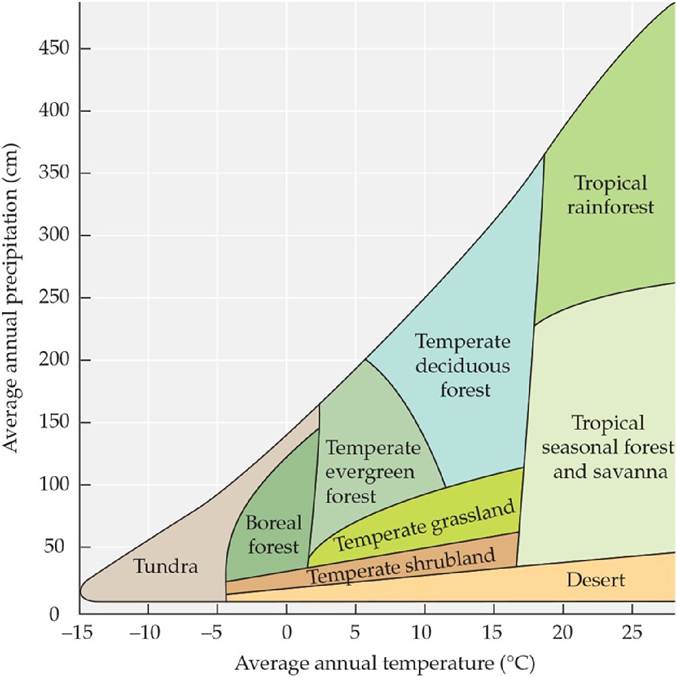
FIGURE 3.4 Biomes Vary with Average Annual Precipitation and Temperature When plotted on a graph of precipitation and temperature, the nine major terrestrial biomes form a triangle.
What factor(s) might result in grasslands or shrublands “invading” climate space occupied by forest or savanna?
(After R. H. Whittaker. 1975. Communities and Ecosystems. Macmillan: London.) View larger image