The potential distributions of terrestrial biomes differ from their actual distributions due to human activities
The effects of land conversion and resource extraction by humans are increasingly apparent on the land surface. These human effects are collectively described as land use change.
Human modification of terrestrial ecosystems began at least 10,000 years ago with the use of fire as a tool to clear forests and enhance the size of game populations. The greatest changes have occurred over the last 150 years, since the onset of mechanized agriculture and logging and an exponential increase in the human population (see Figure 10.2) (Harrison and Pearce 2001). About 75% of Earth’s land surface has been altered by human activities, primarily agriculture, forestry, and livestock grazing; a smaller amount (2%-3%) has been transformed by urban development and transportation corridors (Venter et al. 2016; Sanderson et al. 2002). As a result of these human influences, the potential and the actual distributions of biomes are markedly different (FIGURE 3.5). Temperate biomes, particularly grasslands, have been transformed the most, although tropical and subtropical biomes are experiencing rapid change as well.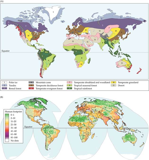
FIGURE 3.5 Global Biome Distributions Are Affected by Human Activities Thepotential distributions of biomes differ from their actual distributions because human activities have altered much of Earth's land surface. (A) The potential global distribution of biomes. (B) Alteration of terrestrial biomes by human activities. The “human footprint” is a quantitative measure (100 = maximum) of the overall human impact on the environment based on geographic data describing human population size, land development, and resource use.
Which biomes in North America and Eurasia appear to have been most affected by human activities? In other words, which biomes in (A) overlap most with areas of high human impact in (B)? In South America and on the Indian subcontinent, which biome has been most degraded by human activity?
(B from E.
W. Sanderson et al. 2002. BioScience 52: 891-904.) View larger imageIn the following sections, we will briefly describe nine terrestrial biomes, their biological and physical characteristics, and the human activities that influence the actual amount of natural vegetation cover that remains in each biome. The description of each biome begins with a map of its potential geographic distribution and a climate diagram showing the characteristic seasonal patterns of air temperature and precipitation at a representative location in that biome (see ECOLOGICAL TOOLKIT 3.1). In addition, sample photos illustrate some of the vegetation types that make up the biome. It is important to remember that each biome incorporates a mix of different communities. Boundaries between biomes are often gradual and may be complex due to variations in regional climate influences, soil types, topography, and disturbance patterns. Thus, the boundaries of biomes portrayed here are only approximations.
ECOLOGICAL TOOLKIT 3.1
Climate Diagrams
A climate diagram is a graph of the average temperatures and amounts of precipitation, by month, at a particular location. Climate diagrams are useful for depicting seasonal patterns of climate conditions. In particular, they provide an indication of when temperatures are below freezing for extended periods (blue-shaded areas in the figure) and when precipitation is insufficient for plant growth. When the precipitation curve falls below the temperature curve (orange-shaded area in the figure), water availability limits plant growth.
Climate diagrams were developed by Heinrich Walter and Helmut Lieth (Walter and Lieth 1967), who used them to show the consistency of climate patterns within the same biomes in different locations. Walter and Lieth demonstrated that by using axes scaled with 1°C corresponding to 2 mm of precipitation, a coarse approximation of time periods when water availability limits plant growth could be made. (Water loss from terrestrial ecosystems is related to temperature, a topic we will take up in more detail in Chapter 4.) For example, the tropical seasonal forest and temperate shrubland and woodland biomes show distinct seasonal periods when water is in short supply, and some temperate grasslands also have predictable low-water seasons.
Climate diagrams also show when temperatures are conducive to plant growth. It is apparent that there is a latitudinal trend toward longer periods of subfreezing temperatures with more extreme lows (larger areas of blue shading).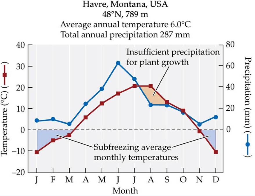
A Sample Climate Diagram A climate diagram contains the name of the climate station where conditions were recorded (Havre, Montana, in this example), its geographic location in latitude, and its elevation. In Havre, there are extended periods of subfreezing temperatures from November to March (blue shaded areas). Frosts do occur outside this time frame, but these isolated events are not reflected in average monthly temperatures. A period of low water availability (orange area) typically occurs from mid-July to October.
(Data from NOAA GHCN-Monthly, version 2; T. C. Peterson and R. S. Vose. 1997. BullAm Meteoroi Soc 78: 2837-2849.) View larger image
Tropical Rainforests
Tropical rainforests are aptly named, as they are found in the low-latitude tropics (between 10°N and S) where precipitation usually exceeds 2,000 mm (79 inches) annually. Tropical rainforests experience warm, seasonally invariant temperatures. The abundant precipitation may be spread evenly throughout the year or occur in one or two main peaks associated with the movement of the intertropical convergence zone (ITCZ) (see Figure 2.21). Seasonal rhythms are generally absent from this biome, and plants grow continuously throughout the year. Tropical rainforests contain a substantial amount of living plant biomass, as mentioned earlier, and they include the most productive ecosystems on Earth. They contain an estimated 50% of Earth's species and about 37% of the terrestrial pool of carbon (C) in only about 11% of Earth's terrestrial vegetation cover (Dixon et al. 1994; Dirzo and Raven 2003). Tropical rainforests occur in Central and South America, Africa, Australia, and Southeast Asia.
The tropical rainforest biome is characterized by broad-leaved evergreen and deciduous trees. Light is a key environmental factor determining the vegetation structure of this biome. Climate conditions that favor plant growth also exert selection pressure either to grow tall above neighboring plants or to adjust physiologically to low light levels. As many as five layers of plants occur in tropical rainforests. Emergent trees rise above the majority of the other trees that make up the canopy of the forest. The canopy consists primarily of the leaves of evergreen trees, which form a continuous layer approximately 30 to 40 m above the ground. Below the canopy, plants that use trees for support and to elevate their leaves above the ground, including lianas (woody vines) and epiphytes (plants that grow on tree branches), are found draped over or clinging to the canopy and emergent trees. Understory plants grow in the shade of the canopy, further reducing the light that finally reaches the forest floor. Shrubs and forbs (broad-leaved herbaceous plants) occupy the forest floor, where they must rely on light flecks that move across the forest floor during the day for photosynthesis.
Globally, tropical rainforests are disappearing rapidly because of logging and conversion of forests to pasture and croplands (FIGURE 3.6). Approximately half of the tropical rainforest biome has been altered by deforestation (Asner et al. 2009; Keenan et al. 2015). Rainforests in Africa and Southeast Asia have been altered the most, and rates of deforestation continue to be greatest in those areas (Wright 2005). In some cases, rainforests have been replaced by disturbance-maintained pastures of forage grasses. In other cases, rainforest is regrowing, but the recovery of the previous rainforest structure is uncertain. Rainforest soils are often nutrient poor, and recovery of nutrient supplies may take a very long time, hindering forest regrowth.
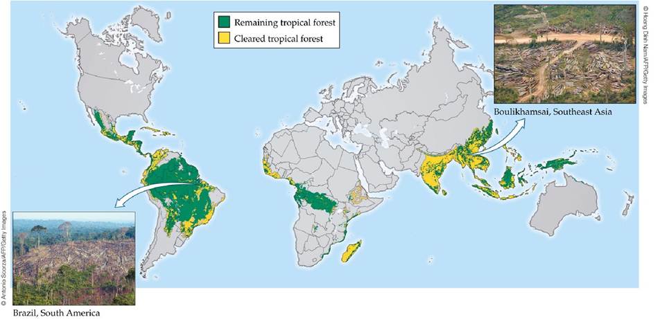
FIGURE 3.6 Tropical Deforestation Large areas of tropical rainforest and seasonal forests have been cleared over the past 40 years, primarily for agricultural and pastoral development.
The loss of these tropical forests has large consequences for loss of biodiversity, regional climate, and carbon uptake and storage. (Map based on data from 2005. After S. L. Pimm and C. Jenkins. 2005. Sci Am 293: 66-73.) View larger image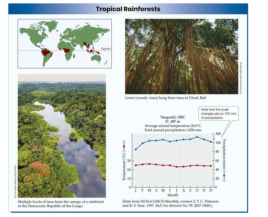
Climate Change Connection
Tropical Forests and Greenhouse Gases
The loss of tropical forests to cutting and burning means more than just the loss of biodiversity. As noted above, almost 40% of the terrestrial carbon is in the tropical forest biome. The loss of the forests means both lower ability of the terrestrial biosphere to take up C from the atmosphere and greater emissions of greenhouse gases into the atmosphere from soils and decaying vegetation (Guo and Gifford 2002). Restoration projects are ongoing in some countries to help address concerns for the loss of diversity and C sequestration abilities associated with tropical forest loss, although their success has not been as effective as natural regeneration (Crouzeilles et al. 2017). How quickly can tropical forests recover and the pools of C be restored once regrowth is started? A review of more than 600 sites indicates that recovery of the plant biomass above the soil surface occurs within 85 years of regrowth, but a longer time is required for recovery of plant biomass in the soil (Martin et al. 2013). This analysis provides optimism for potential reversal of the contribution of tropical deforestation to atmospheric greenhouse gas concentrations. However, the analysis also found that while tree diversity recovers after 50 years, more than a century is required for full plant species recovery, including lianas and epiphytes.
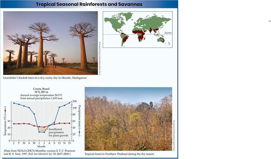
Tropical Seasonal Forests and Savannas
As we move to the north and south of the wet tropics toward the Tropics of Cancer (23.5°N) and Capricorn (23.5°S), rainfall becomes seasonal, with pronounced wet and dry seasons associated with shifts in the ITCZ.
This region is marked by a large gradient in climate primarily associated with the seasonality of rainfall. The responses of vegetation to the greater seasonal variability include shorter stature, lower tree densities, and an increasing degree of drought deciduousness, with leaves dropping from the trees during the dry season. In addition, there is a greater abundance of grasses and shrubs and fewer trees than in rainforests.The tropical seasonal biome includes several different vegetation complexes, including tropical dry forests, thorn woodlands, and tropical savannas. The frequency of fires, which increases with the length of the dry season, influences the vegetation growth forms. Recurrent fires, sometimes set by humans, promote the establishment of savannas, communities dominated by grasses with intermixed trees and shrubs. In Africa, large herds of herbivores, such as wildebeests, zebras, elephants, and antelopes, also influence the balance between trees and grasses and act as an important force promoting the establishment of savannas. On the floodplains of the Orinoco River in South America, seasonal flooding contributes to the establishment of savannas, as trees are intolerant of long periods of soil saturation. Thorn woodlands (communities dominated by widely spaced trees and shrubs) get their name from the protective thorns on the trees, which act as a deterrent to herbivores that would consume the vegetation. Thorn woodlands typically occur in regions with climates intermediate between tropical dry forests and savannas.
Tropical seasonal forests and savannas once covered more area than tropical rainforests, but today less than half of this biome remains intact. Increasing human demand for wood and agricultural land has resulted in loss of tropical seasonal forests and savannas at rates equal to or greater than those for tropical rainforests (Bullock et al. 1995). Large increases in human populations in tropical dry forest regions have had a particularly large effect. Large tracts of tropical dry forest in Asia and Central and South America have been converted to cropland and pasture to meet the needs of growing human populations for food and earnings from agricultural goods exported to more-developed countries.
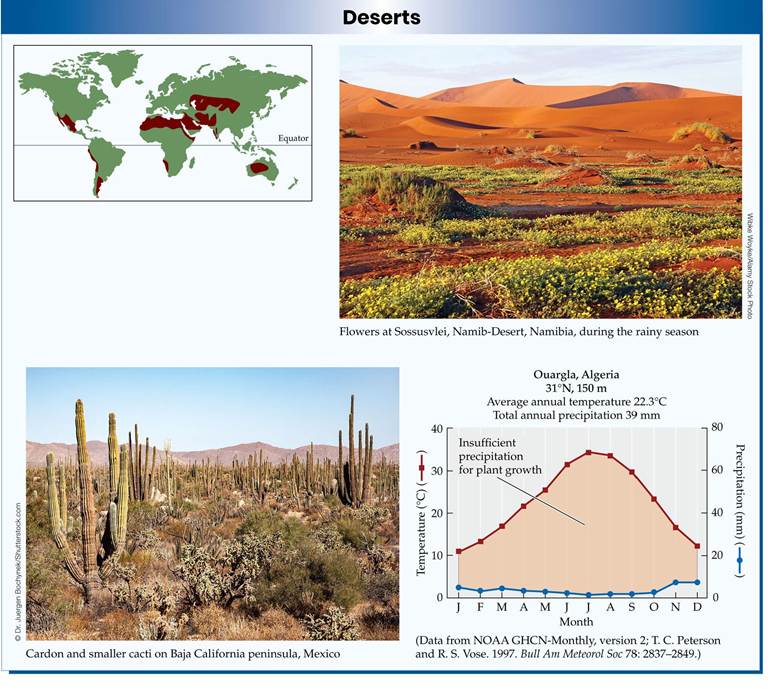
Deserts
In contrast to the tropical ecosystems, deserts contain sparse populations of plants and animals, reflecting sustained periods of high temperatures and low water availability. The subtropical positions of hot deserts correspond with the high-pressure zones of the Hadley cells (see Figure 2.8) around 30°N and S, which inhibit the formation of storms and their associated precipitation. Low precipitation levels, coupled with high temperatures and high rates of evapotranspiration, result in a limited supply of water for desert organisms. The major desert zones include the Sahara; the Arabian deserts; the Gobi in Asia; the Atacama Desert of Chile and Peru; and the Chihuahuan, Sonoran, and Mojave Deserts of North America.
Low water availability is an important constraint on the abundance of desert plants as well as an important influence on their form and function. One of the best examples of convergence in plant form is the occurrence of stem succulence in desert plants. Stem succulence occurs in both the cacti of the Western Hemisphere and the euphorb family of the Eastern Hemisphere (FIGURE 3.7). Plants with succulent stems can store water in their tissues to help the plants continue to function during dry periods. Other plants of the desert biome include drought-deciduous shrubs and grasses. Some short-lived annual plants are active only after sufficient precipitation has fallen. These annual plants carry out their entire life cycle, from germination through flowering and seed production, in a few short weeks. Although the abundance of organisms may be low, species diversity can be high in some deserts. The Sonoran Desert, for example, has over 4,500 plant species, 1,200 bee species, and 500 bird species (Nabhan and Holdsworth 1998).
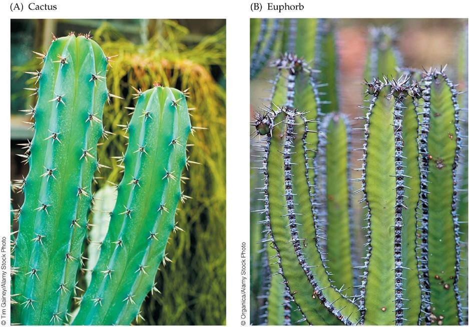
FIGURE 3.7 Convergence in the Forms of Desert Plants (A) The blue candle cactus (Myrtillocactus geometrizans) is native to the Chihuahuan Desert of Mexico. (B) Euphorbia
polyacantha has cactus-like characteristics. Although only distantly related, both species have succulent stems, water-conserving photosynthetic pathways, upright stems that minimize midday sun exposure, and spines that protect them from herbivores. These traits evolved independently in each species. View larger image
Humans have used deserts for livestock grazing and agriculture for centuries. Agricultural development in desert areas is dependent on irrigation, often using water that flows in from distant mountains or is extracted from deep underground. Unfortunately, irrigated agriculture in deserts has repeatedly failed because of salinization (see Concept 2.6). Livestock grazing in deserts is also a risky venture because of the unpredictable nature of the precipitation needed to support plant growth for herbivores. Long-term droughts in association with unsustainable grazing practices can result in loss of plant cover and soil erosion, a process known as desertification. Desertification is a concern in populated regions at the margins of deserts, such as the Sahel region in the southern portion of the Sahara in Africa.
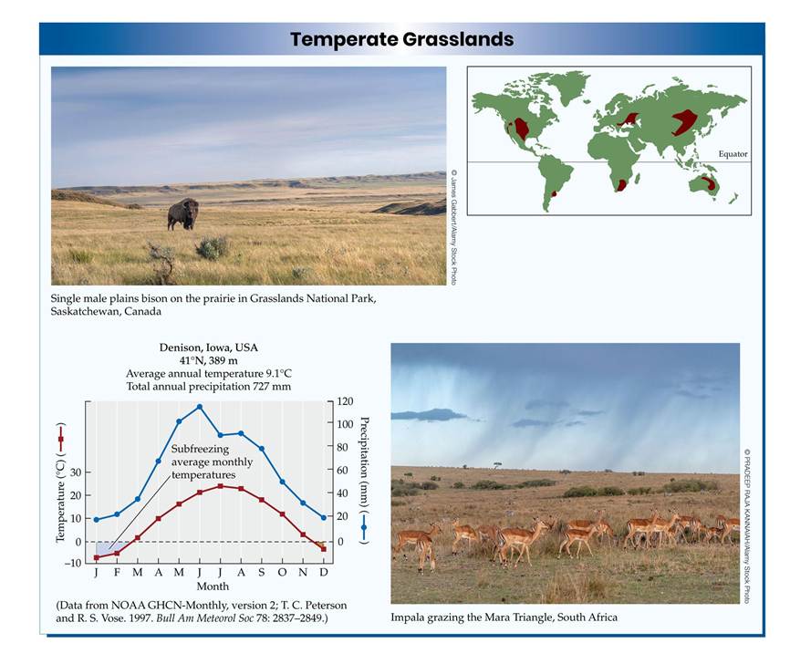
Temperate Grasslands
Large expanses of grasslands once occurred throughout North America and Eurasia (the Great Plains and the steppes of Central Asia) at latitudes between 30° and 50°N. Southern Hemisphere grasslands are found at similar latitudes on the east coasts of South America, New Zealand, and Africa. These vast, undulating expanses of grass-dominated landscape have often been compared to a terrestrial ocean, with wind-driven “waves” of plants bending to the gusts blowing through them.
Temperate climates have greater seasonal temperature variation than tropical climates, with increasing periods of subfreezing temperatures toward the poles. Within the temperate zone, grasslands are usually associated with warm, moist summers and cold, dry winters. Precipitation in some grasslands is high enough to support forests, as at the eastern edge of the Great Plains. However, frequent fires and grazing by large herbivores such as bison prevent the establishment of trees and thus maintain the dominance of grasses in these environments. The use of fire to manage grasslands near the edges of forests was probably one of the first human activities with a widespread effect on a terrestrial biome.
The world's grasslands have been a major focus for agricultural and pastoral development. In order to acquire adequate supplies of water and nutrients, grasses grow more roots than stems and leaves. The rich organic matter that accumulates in the soils as a result enhances their fertility, so grassland soils are particularly well suited for agricultural development. Most of the fertile grasslands of central North America and Eurasia have been converted to agriculture. The diversity of the crop species grown on these lands is far less than the diversity of the grasslands they replaced. In more arid grasslands, rates of grazing by domesticated animals can exceed the capacity of the plants to produce new tissues, and grassland degradation, including desertification, may occur. As in deserts, irrigation of some grassland soils has resulted in salinization, decreasing their fertility over time. In parts of Europe, cessation of centuries-old grazing practices has resulted in increased forest invasion into grasslands. This long legacy of use for agriculture and grazing has made grasslands the most human-influenced biome on Earth. You can evaluate the possible effects of climate change in ANALYZING DATA 3.1.
ANALYZING DATA 3.1
How Will Climate Change Affect the Grasslands Biome?
The climate diagrams shown for each of the terrestrial biomes exemplify the climate patterns with which they are associated (see Ecological Toolkit 3.1). In particular, they show periods of potential plant stress due to low water availability and subfreezing temperatures, which are particularly important in shaping the types of plants that grow in a given location. Global climate change is altering both temperature and precipitation patterns worldwide. Eventually, therefore, the species composition of the biome at a given site will change, as happened following the end of the last ice age.
The world's remaining grasslands are particularly threatened by climate change. Much of this biome has already been lost and fragmented by land use change for agricultural and pastoral activities. Current predictions for the tallgrass prairie of the central United States suggest that by 2050, its average annual temperature will increase by 2.3°C and total annual precipitation will not change.
1. Assuming that the changes in temperature occur evenly across the year, draw climate diagrams representing the current and year 2050 conditions for Ellsworth, Kansas, a grassland site in the southern Great Plains. Use the data in the table below for the current climate.
2. Redraw the climate diagram assuming that winter (December, January, February) precipitation increases by 20% and that summer (June, July, and August) precipitation decreases by 20%, as predicted by some climate change models.
3. Does the diagram from Question 2 show changes in the periods of possible water and temperature stress? If so, how do you think these changes will influence the vegetation composition of the tallgrass prairie? Use the information in Ecological Toolkit 3.1 to assist your reasoning.
4. What factors other than climate should be considered in a prediction of the future fate of the grassland biome?
Ellsworth, Kansas, 38o43' N, 98o14' W, 466 m elevation
| J | F | M | A | M | J | J | A | S | O | |
| Average monthly temperature (°C) | -2.1 | 0.9 | 6.9 | 13.1 | 18.3 | 23.8 | 26.9 | 25.7 | 20.7 | 14.3 |
| Average monthly precipitation (mm) | 15.2 | 19.8 | 56.6 | 61.5 | 104.1 | 102.4 | 81.8 | 84.1 | 79.0 | 56.1 |
Source: http://www.ellsworth.climatemps.com/
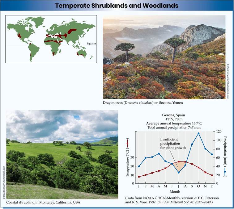
Temperate Shrublands and Woodlands
The seasonality of precipitation is an important control on the distribution of temperate biomes. Woodlands (characterized by an open canopy of short trees) and shrublands occur in regions with a winter rainy season (in contrast to grasslands, with a summer rainy season). Mediterranean-type climates, which occur on the west coasts of the Americas, Africa, Australia, and Europe between 30° and 40°N and S, are an example of such a climate regime. As we saw in Concept 2.1, these Mediterranean-type climates are characterized by asynchrony between precipitation and the summer growing season (the period of time with suitable temperatures to support growth). Precipitation falls primarily in winter, and hot, dry weather occurs throughout the late spring, summer, and fall. The vegetation of Mediterranean-type climates is characterized by evergreen shrubs and trees. Evergreen leaves allow plants to be active during cooler, wetter periods and also lower their nutrient requirements, since they do not have to grow new leaves every year. Many plants of Mediterranean-type climates have sclerophyllous leaves, which are tough, leathery, and stiff. These plants are well adapted to dry soils and may continue to photosynthesize and grow at reduced rates during the hot, dry summer. Sclerophyllous leaves also help to deter
consumption by herbivores and prevent wilting as water is lost. Sclerophyllous shrublands are found in each of the zones characterized by a Mediterranean-type climate, including the mallee of Australia, the fynbos of South Africa, the matorral of Chile, the maquis around the Mediterranean Sea, and the chaparral of North America.
Fire is a common feature in Mediterranean-type shrublands and, as it does in some grasslands, may promote their persistence. Some of the shrubs recover after fires by resprouting from woody storage organs protected from the heat below the ground surface. Other shrubs produce seeds that germinate and grow quickly after a fire. Without regular fires at 30- to 40-year intervals, some temperate shrublands may be replaced by forests of oaks, pines, junipers, or eucalypts. Regular disturbance by fire, combined with the unique climate of temperate shrublands, is thought to promote high species diversity.
Shrublands and woodlands are also found in the continental interior of North America and Eurasia, where they are associated with rain shadow effects and seasonally cold climates. The Great Basin, for example, occupies the interior of North America between the Sierra Nevada and the Cascade Range to the west and the Rocky Mountains to the east. Large expanses of sagebrush (Artemisia tridentata), saltbush (Atriplex spp.), creosote bush (Larrea tridentata), and pinon pine and juniper woodland occur throughout this area.
Humans have converted some regions of temperate shrublands and woodlands to croplands and vineyards. However, their climates and nutrient-poor soils have limited the extent of agricultural and pastoral development. In the Mediterranean basin, agricultural development using irrigation was attempted but failed because of the infertile soils. Urban development has reduced the cover of shrublands in some regions (e.g., Southern California). Increases in local human populations have increased the frequency of fires, which has decreased the ability of shrubs to recover and may lead to their replacement by invasive annual grasses.
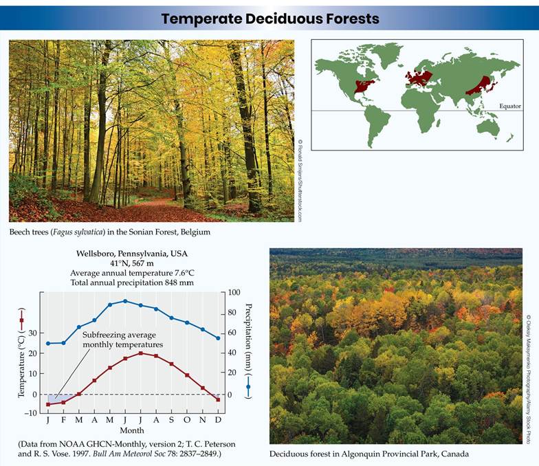
Temperate Deciduous Forests
Deciduous leaves are a solution to the extended periods of freezing weather in the temperate zone. Leaves are more sensitive to freezing than other plant tissues because of the high level of physiological activity associated with photosynthesis. Temperate deciduous forests occur in areas where there is enough rainfall to support tree growth (500-2,500 mm, or 20-100 inches, per year) and where soils are fertile enough to supply the nutrients lost when leaves are shed in the fall. Temperate deciduous forests are primarily limited to the Northern Hemisphere, as the Southern Hemisphere contains less land area and lacks extensive areas with the continental climates associated with the deciduous forest biome.
Deciduous forests occur at 30° to 50°N on the eastern and western edges of Eurasia and in eastern North America, extending inland to the continental interior before diminishing because of lack of rainfall and, in some cases, increased fire frequency. Similar species occur on each of these continents, reflecting a common biogeographic history (see Chapter 18). Oak, maple, and beech trees, for example, are components of this forest biome on each continent. The vertical structure of the forest includes canopy trees as well as shorter trees, shrubs, and forbs below the canopy. Species diversity is lower than in tropical forests but can be as high as 3,000 plant species (e.g., in eastern North America). Disturbances such as fire and outbreaks of herbivorous insects do not play a major role in determining the development and persistence of temperate deciduous forest vegetation, although they can influence its boundaries, and periodic outbreaks of herbivores (e.g., the gypsy moth, a non-native insect introduced to North America) do occur.
The temperate deciduous forest biome has been a focus for agricultural development for centuries. The fertile soils and climate are conducive to the growth of crops. Forest clearing for crop and wood production has historically been widespread in this biome. Very little old-growth temperate deciduous forest remains on any continent. Since the early twentieth century, however, agriculture has gradually shifted away from temperate-zone forests toward temperate grasslands and the tropics, particularly in the Americas. Abandonment of agricultural fields has resulted in reforestation in some parts of Europe and North America. However, the species composition of the second-growth forests often differs from what was present prior to agricultural development. Nutrient loss from soils due to long-term agricultural use is one reason for this difference. Another is the loss of some species due to introductions of invasive species. For example, the chestnut blight fungus, introduced from Asia, nearly wiped out the chestnut trees (Castanea spp.) of North America in the early twentieth century (see Figure 13.14). As a result, oak species are more widespread than they were prior to agricultural development.
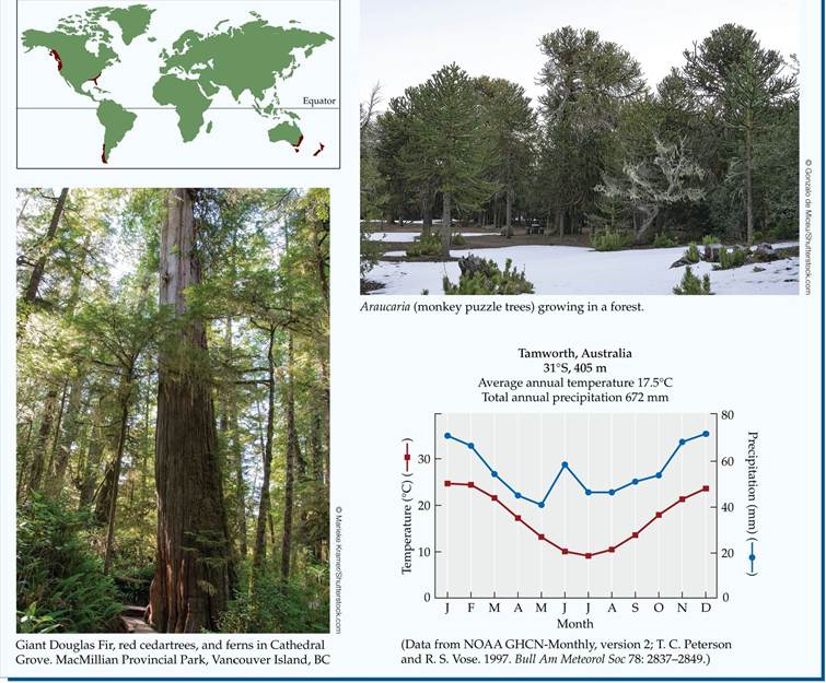
Temperate Evergreen Forests
Evergreen forests span a wide range of environmental conditions in the temperate zone, from warm coastal regions to cool continental and maritime climates. Precipitation also varies substantially among these forests, from 500 to 4,000 mm (20-150 inches) per year. Some temperate evergreen forests with high levels of precipitation, which are typically located on west coasts at latitudes between 45° and 50°N and S, are referred to as “temperate rainforests”
(FIGURE 3.8). Temperate evergreen forests are commonly found on nutrientpoor soils, whose condition is in part related to the acidic nature of the leaves of the evergreen trees. Some evergreen forests are subject to regular fires at intervals of 30-200 years, which may promote their persistence.
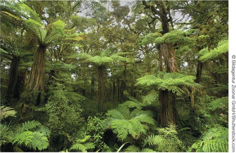
FIGURE 3.8 Temperate Rainforest Rainforests occur in temperate zones with high precipitation (over 5,000 mm, or 200 inches) and relatively mild winter temperatures. Here, understory tree ferns grow beneath the canopy trees at Horseshoe Falls in western Tasmania, Australia. View larger image
Temperate evergreen forests are found in both the Northern and Southern Hemispheres between 30° and 50° latitude. Their diversity is generally lower than that of deciduous and tropical forests. In the Northern Hemisphere, the tree species include needle-leaved conifers such as pines, junipers, and Douglas fir (Pseudotsuga menziesii). In the Southern Hemisphere, on the west coasts of Chile and Tasmania, in southeastern and southwestern Australia, and in New Zealand, there is a greater diversity of tree species, including southern beeches (Nothofagus spp.), eucalypts, the Chilean cedar (Austrocedrus), and podocarps
(see Figure 18.4).
Conifers provide a source of high-quality wood and pulp for paper production. The temperate evergreen forest biome has been subjected to extensive clearing, and little old-growth forest remains. Some forestry practices tend to promote sustainable use of these forests, although in some regions the planting of nonnative species (such as Monterey pine in New Zealand), the uniform age and density of the trees, and losses of formerly dominant species have created forests that are ecologically very different from their pre-logging condition. The suppression of naturally occurring fires in western North America has increased the density of some forest stands, which has resulted in more intense fires in association with climate change (Dennison et al. 2014) and has increased the spread of insect pests (e.g., pine beetles) and pathogens. In industrialized countries, the effects of air pollution have damaged some temperate evergreen forests (see Figure 25.18) and made them more susceptible to other stresses.
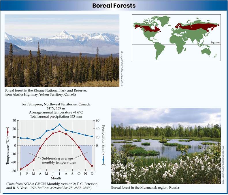
Boreal Forests
Above 50°N, the severity of winters increases. Minimum temperatures of -50°C (-58°F) are common in continental locations such as Siberia, and continuous subfreezing temperatures may last up to 6 months. The extreme weather in these subarctic regions is an important determinant of the vegetation structure. Not only must the plants cope with low air temperatures, but soils may regularly freeze, leading to the formation of permafrost, defined as a subsurface soil layer that remains frozen year-round for at least 3 years. Although precipitation is low, the permafrost impedes water drainage, so soils are moist to saturated.
The biome that occupies the zone between 50° and 65°N is the boreal (far northern) forest. This biome is also known as taiga, the Russian word for this northern forest. It is composed primarily of coniferous species, including spruces, pines, and larches (deciduous needle-leaved trees), but also includes extensive deciduous birch forests in maritime locations, particularly in Scandinavia. Conifers tend to resist damage from winter freezing better than angiosperm trees, despite maintaining green leaves year-round. Although the boreal forest is found only in the Northern Hemisphere, it is the largest biome in area and contains one-third of Earth's forested land.
Boreal forest soils are cold and wet, limiting the decomposition of plant material such as leaves, wood, and roots. Thus, the rate of plant growth exceeds the rate of decomposition, and the soils contain large amounts of organic matter. During extensive summer droughts, forests are more susceptible to fires ignited by lightning. These fires may burn both the trees and the soil (FIGURE 3.9). Soil fires may continue to burn slowly for several years, even through the cold winters. In the absence of fire, forest growth enhances permafrost formation by lowering the amount of sunlight absorbed by the soil surface. In low-lying areas, soils become saturated, killing the trees and forming extensive peat bogs.
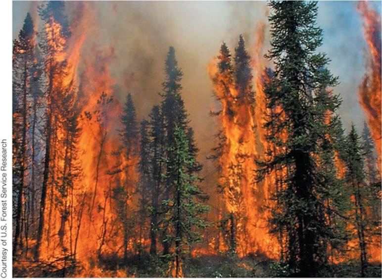
FIGURE 3.9 Fire in the Boreal Forest Despite the cold climate of the boreal forest, fire is an important part of its environment. View larger image
Boreal forests have been less affected by human activities than other forest biomes. Logging occurs in some regions, as does oil and gas development, including the mining of oil sands. These activities pose an increasing threat to the boreal forest as demands for wood and energy increase. In addition, the large store of organic matter in the soil makes boreal forests an important component of the global carbon cycle. Climate warming may result in more rapid decomposition and thus higher rates of carbon release from boreal forest soils, increasing atmospheric greenhouse gas concentrations that in turn cause additional warming (see Concept 25.2).
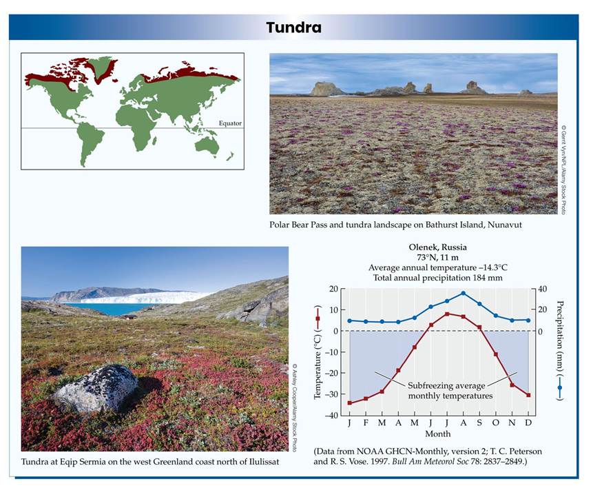
Tundra
Trees cease to be the dominant vegetation beyond approximately 65° latitude. The tree line that marks the transition from boreal forest to tundra is associated with low growing-season temperatures, although the causes of this transition are complex and can also include other climate and soil conditions. The tundra biome occurs primarily in the Arctic but can also be found on the edges of the Antarctic Peninsula and on a few islands in the Southern Ocean. The poleward decrease in temperature and precipitation across the tundra biome is associated with the zones of high pressure generated by the polar atmospheric circulation cells (see Figure 2.8).
The tundra biome is characterized by sedges, forbs, grasses, and low-growing shrubs such as heaths, willows, and birches. Lichens and mosses are also important components of this biome. Although the summer growing season is short, the days are long, with continuous periods of light for 1 to 2 months of the summer. The plants and lichens survive the long winter by going dormant, maintaining living tissues under the snow or soil, where they are insulated from the cold air temperatures.
The tundra and the boreal forest have several similarities: temperatures are cold, precipitation is low, and permafrost is widespread. Despite the low precipitation, many tundra areas are wet, as the permafrost keeps the precipitation that does fall from percolating to deeper soil layers. Repeated freezing and thawing of surface soil layers over several decades results in sorting of soil materials according to their texture. This process forms polygons of soil at the surface with upraised rims and depressed centers (FIGURE 3.10). Where soils are coarser or permafrost does not develop, the soils may be dry, and plants must be able to cope with low water availability. These polar deserts are most common at the high latitude limit of the tundra biome.
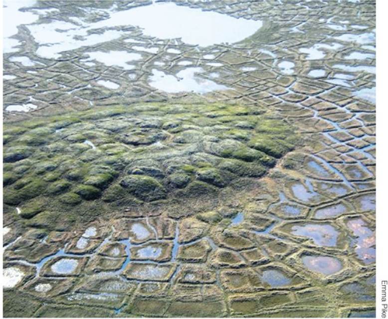
FIGURE 3.10 SoilPolygonsandPingo Pingos are small hills found in the Arctic, formed by an intrusion of water that freezes in the subsurface permafrost zone, thrusting the soil above it upward. The polygons on the periphery of the pingo result from freezing and thawing of soils, a process that pushes coarse soil materials toward the edges and finer soil to the middle of the polygons. View larger image
Herds of caribou and musk oxen, as well as predators such as wolves and brown bears, inhabit the tundra. Many species of migratory birds nest in the tundra during the summer. Human inhabitants are scattered in sparse settlements. As a result, this biome contains some of the largest pristine regions on Earth. The influence of human activities on the tundra is increasing, however. Exploration and development of energy resources has accelerated. A key to limiting the effects of energy development is preventing damage to the permafrost, which can cause long-term erosion. The Arctic has experienced climate warming almost double the global average during the late twentieth and early twenty-first
centuries. Increased losses of permafrost, catastrophic lake drainage, and reduced carbon storage in the soil have been linked to climate change.
Now that we've completed our tropics-to-tundra tour of terrestrial biomes, let's consider the influence of mountains on more local-scale patterning of biological communities. In some mountainous locations, elevational changes result in a smaller version of our latitudinal description of biomes.