Conclusion
The shifts we see beginning in the early modern period, which began with commercial demand for better geographical knowledge for navigational purposes, became fully formed under state sponsorship of technologies that produce a kind of legibility that allows both territory and peoples to be tallied in ways that rely on standardization of measurement useful to representing and regulating territory from a distance.[667] With the advent of latitude and longitude to represent specific coordinates on the globe, space became globally integrated; individual countries, empires even, could no longer maintain separate conceptual centers in the same way.
Rather, they came to occupy a fixed amount of territory in finite space, along with other polities, in relationships that were defined either according to national sovereignty or imperial exploitation. Time came to be measured on maps not in human terms, such as the needs of the traveler’s body for rest[668] or the distance that could reasonably be covered by an army on foot in a day, but was marked out in minutes and seconds according to the same system of latitudinal measure that corresponded with the movement of the earth in space and distance on the ground. The precision of clocks developed to measure distance accurately in this way, when turned to regulate human activity, functioned independently of whether bodies were tired or rested, hungry or well nourished, and whether operating in daylight or darkness. Compensated labor could be measured in numbers of hours worked, other considerations aside. In other words, administration came increasingly to require that one standard or uniform view prevail. These same techniques are ill suited to capturing, or demonstrating, regional specificities and variation in local terms whether in the metropole, or abroad. This transition to what we might call scientific mapping took several centuries to unfold, and indeed, while measurement-based scientific methods of representation are now quite pervasive, they are not entirely hegemonic in their reach. Nor will they ever be, as no representation can ever perfectly mimic the object it represents.Although increasing value placed on direct observation, on precise measurement, and scientifically accurate representation that began to emerge during the early modern period has long been described as “Western” or “European,” and was certainly used by Western powers in their quest for power, the emergence of these forms of knowledge and their identification with precise measurement are better understood as products of state sponsorship of scientific advancement rather than as “European” per se. The mutual accommodation between science and the state had repercussions for both state wealth and power and for the advancement of science as an actor in its own right. While the mutually beneficial relationship between state power and science was indeed characteristic of the strongest nations of Europe during the early modern period—viz. the development of the Academies of Science—state patronage of early modern cartographic methods and ethnographic efforts to order people was not limited to Europe.[669] A variety of early modern empires used scientific map technology and/or catalogued the various groups who peopled their empires, including the Mongol, Ottoman, Mughal, Russian, and Qing empires, and at times partook in connections to the same information network. During the late imperial period in Europe, however, with the increasing economic and imperial ascendancy of individual European imperial powers, shifting relationships between politics and capital, and the increasing tendency to privilege what could be measured and catalogued over other forms of knowing, the association between “Europe” and “science” became entrenched, not least as part of Europe's own self-definition.
Even as new cartographic practices began to shift associations with the heavens from the divine to the scientific, separate genres also emerged to accommodate other fields of knowledge.
Early maps of discovery had often depicted both land and peoples on the same map, a phenomenon we see in both early European maps of exploration and in frontier maps of the Qing dynasty during the eighteenth century. However, as maps became more cartographic and knowledge of peoples more thoroughly documented, distinct cartographic and ethnographic genres emerged. Scientific method and its need to quantify information numerically, to form “immutable mobiles”—that is to say, fixed units of information that could then easily be transported around the globe to be interpreted at a distance and combined with other bits of information represented in like manner—required the separation of cartographic and ethnographic information.[670] Censuses and other forms of registration were, like maps, by no means unique to the early modern and modern periods, but nonetheless they often followed in the wake of imperial cartography and were dictated by similar logics.Modern European imperialism is in many ways about the forceful introduction of different ways of seeing and knowing. These were not only abstract ways of conceptualizing territory and peoples from afar. Rather, ways of identifying and defining the land and its inhabitants had concrete consequences for those who peopled it. As James Scott has written, state simplifications were “not just maps. Rather, they were maps that, when allied with state power, would enable much of the reality they depicted to be remade.”[671] This process is seen through the imposition of cadastral mapping on lands once held commonly. In New Spain, Spanish colonists “converted once-indigenous land into their personal property” so effectively that indigenous artists began to make maps reflecting these changes to the landscape.[672] Sometimes the changes even began with the map itself. John Smith described in 1623 how a map he had made of New England was cut into pieces to divide the land by lots as a means of allocating it to “a group of twenty prominent colonial speculators.”[673] By 1641 the Massachusetts Bay Colony required each town “within its jurisdiction to have its boundaries surveyed and recorded in a plan” which would then become part of a larger set of documentary evidence “sanctioning the taking of the lands of the Indians.”[674] In Europe, too, in rural areas “former commons were...
subdivided and allotted, with the help of maps” which “entered the law, were attached to ordinances, acquired an aureole of science, and helped create an ethic and virtue of ever more precise definition.”[675] In the scramble for ownership and control, the wealth of the land that had supported whole communities for generation upon generation was at once rendered invisible and wrested from those who had previously stewarded it, becoming a new type of commodity in the process. The 1884-1885 Berlin Conference, at which a group of Europeans agreed upon and drew up maps of “their” respective lands and interests in Africa, has the same flavor.[676] The resulting maps came to create a reality on the ground that transformed the very relationship between the land and the people who lived on and drew their livelihood from it.[677] Yet, this type of imperial practice did not remain confined to Europe. Similar processes would later play out with other, non-Western, actors as when, in the mid-twentieth century, the government of the People's Republic of China took over the administration of and redefined land use in Qinghai and Tibet.[678]Whether in the context of Siberia, Virginia, New Spain, India, South America, or Africa, European imperial cartography—and censuses when they were carried out—prioritized and imposed categories through which to define, to “know,” and to represent the world differently from the indigenous ways of knowing those places and their inhabitants. A similar gaze had already been adopted at home in the context of national formation. Literacy in the new ways of knowing and seeing were broadly introduced and propagated within the nation, while this kind of work was not undertaken among populations abroad. Rather, at best, it was assumed that indigenous peoples would not understand the technology involved. The nation distinguished itself from the colony by its modern embrace of the new knowledge systems, whereas it excluded those in the colony—and its own internal others— from initiation, thus rendering them illiterate.
Domestically, the rhetorical and legal creation of communities of inclusion within the nation provided a sense of solidarity and belonging, as well as a sense of buy-in to the imperial project abroad. Exclusion of indigenous peoples in imperial colonies from positions of wealth and privilege through the invention of race, and the legal and social mechanisms encoding it, perpetuated privilege among the domestic agents of empire abroad while limiting opportunities for indigenous peoples. Introducing new patterns of land use and foreign systems of law to back them up provides one example of how mechanisms were often actively created to keep indigenous peoples in subservient positions, locked outside of the benefits that could accrue from adopting new ways of knowing. Imperial subjects abroad were to be the objects of the new forms of knowledge, rather than their beneficiaries, as if the practice of science could somehow be inextricably or permanently linked to what it meant to be European.The iconography on Victor Levasseur's 1845 French map of Africa, a softer or “friendlier” colonialism than that portrayed on many imperial maps, nonetheless encapsulates the promises and perils of the imperial introduction of new knowledge systems.[679] In the cartouche, a young French soldier holds up for an older local turbaned man an image of this man's homeland mapped. Doubtless, the man was in many ways more familiar with his homeland than the foreign interloper, yet as the young man points to the map he seems to be inviting his elder to see these lands in a new way, and as if for the first time. The implicit alternative was to be consigned forever to darkness. An unchanged existence was not an option; should the older man continue to live according to the vision his previous life afforded, he would be forever consigned to servitude, without the benefit of the light. Change, whether welcome or not, was inevitable.
Once those in the colonies began to master the new technologies, they typically rejected not the new ways of seeing and governing, but rather the outsiders who introduced them, ousting the foreign powers even as they adopted the new techniques in order to establish their own autonomous nations.
Yinka Shonibare captures the continuity between imperial and postcolonial relationships to Africa's land in a powerful piece of contemporary art. In Scramble for Africa (2003), he has placed a group of headless manikins dressed in suits made of bright African fabrics around a large wooden table. Gathered around a map of Africa, their postures and gestures invoke the 1884-1885 Berlin Conference; the activities of dividing, claiming, and justifying continue under a new guise (see Figure 8.6).[680]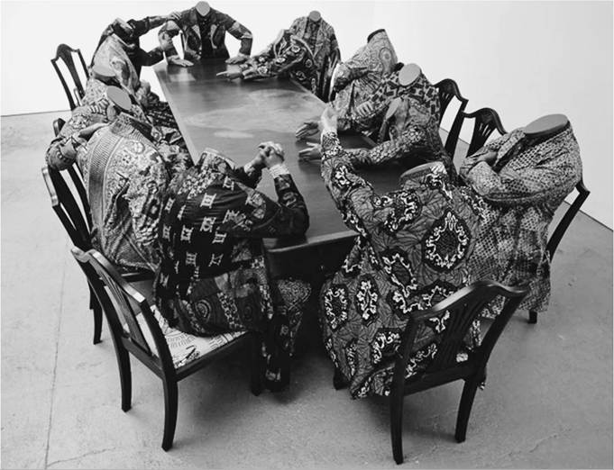
Figure 8.6. Yinka Shonibare, The Scramble for Africa (2003). Source:© Yinka Shonibare MBE. All Rights Reserved, DACS/ ARS, NY 2018.
In other words, even as individual polities strive to fit themselves into the legacy of the global system of time and space inherited from the contests of the late imperial period, they impose on their own realms the same kind of order by creating or adopting standard forms of measure. At the same time, the adoption of these new techniques often goes hand in hand with patronage of symbols of national identity and cultural heritage in order to bolster national identity, the very preservation of which provides legitimacy to the new government and serves to distinguish it from the former colonizers, even as it serves to minimize various forms of difference within the nation itself.[681]
Bibliography
Akerman, J. R. 2009a. “Introduction.” In J. R. Akerman, ed., The Imperial Map: Cartography and the Mastery of Empire, 1-9. Chicago.
Anderson, B. 1991. Imagined Communities: Reflections on the Origin and Spread of Nationalism. London and New York.
Atkinson, D. 1995. “Geopolitics, Cartography and Geographical Knowledge: Envisioning Africa from Fascist Italy.” In M. Bell et al., eds., Geography and Imperialism, 1820-1940, 265-297. Manchester, UK.
Bang, P., and D. Kolodziejczyk, eds. 2012. Universal Empire: A Comparative Approach to Imperial Culture and Representation in Eurasian History. Cambridge, UK.
Barkey, K. 2008. Empire of Difference: The Ottomans in Comparative Perspective. Cambridge, UK. Barrow, I. J. 2003. Making History, Drawing Territory: British Mapping in India, c. 1756-1905.
New Delhi.
Barrow, I. J. 1994. “Cartography and Empire Building in Nineteenth-Century West Africa.” Geographical Review 84, no. 3: 316-335.
Bassett, T. J., and P. W Porter. 1991. “‘From the Best Authorities’: The Mountains of Kong in the Cartography of West Africa.” The Journal of African History 32, no. 3: 367-413.
Bayly, C. A. 1996. Empire and Information: Intelligence Gathering and Social Communication in India, 1780- 1870. Cambridge, UK.
Blaut, J. M. 1993. The Colonizer’s Model of the World: Geographical Diffusionism and Eurocentric History. New York.
Breckenridge, K. D., and S. Szreter, eds. 2012. Registration and Recognition: Documenting the Person in World History. Oxford.
Burbank, J., and F. Cooper. 2010. Empires in World History: Power and the Politics of Difference. Princeton, NJ.
Cams, M. 2016. “Companions in Geography: Maps, Instruments and the Mapping of Qing China (c. 1685-1735).” PhD dissertation, Leuven.
Casale, G. 2011. The Ottoman Age of Exploration. Oxford.
Cohn, B. S. 1987. An Anthropologist among the Historians and Other Essays. Delhi.
Cohn, B. S. 1996. Colonialism and Its Forms of Knowledge: The British in India. Princeton, NJ.
Cook, J., E. C. Nordyke, and J. A. Mattison. 2008. Pacific Images: Views from Captain Cook’s Third Voyage: Engravings and Descriptions from a Voyage to the Pacific Ocean, Volumes I, II, and III, and the Atlas by Captain James Cook and Captain James King, Published as the Official Edition of the Lords Commissioners of the Admiralty, in London, 1784: Featuring Stamps Related to Captain James Cook and His Voyages of Discovery from the Ron V. Meads Collection, 2nd ed. Honolulu.
Craib, R. 2004. Cartographic Mexico: A History of State Fixations and Fugitive Landscapes. Durham, NC.
Crosby, A. W 1997. The Measure of Reality: Quantification and Western Society, 1250-1600. Cambridge, UK.
Deal, D. M., and L. Hostetler, eds. 2006. The Art of Ethnography: A Chinese “Miao Album.” Seattle.
Edney, M. H. 1997. Mapping an Empire: The Geographical Construction of British India, 17651843. Chicago.
Edney, M. H. 2009. “The Irony of Imperial Mapping.” In J. R. Akerman, ed., The Imperial Map: Cartography and the Mastery of Empire, 11-45. Chicago.
Etherington, N. 2007. “Putting Tribes on Maps.” In N. Etherington, ed., Mapping Colonial Conquest: Australia and Southern Africa, 79-101.
Foss, T N. 1988. “A Western Interpretation of China: Jesuit Cartography.” In C. E. Ronan, ed., East Meets West: The Jesuits in China, 1582-1773, 209-251. Chicago.
Harley, J. B. 1988. “Silences and Secrecy: The Hidden Agenda of Cartography in Early Modern Europe.” Imago Mundi 40: 57-76.
Harley, J. B. 2001a. “Texts and Contexts in the Interpretation of Early Maps.” In J. B. Harley, and P. Laxton, eds., The New Nature of Maps: Essays in the History of Cartography, 33-50. Baltimore, MD.
Harley, J. B. 2001b. “Maps, Knowledge, and Power.” In J. B. Harley and P. Laxton, eds., The New Nature of Maps: Essays in the History of Cartography, 51-81. Baltimore.
Harley, J. B. 2001c. “Silences and Secrecy: The Hidden Agenda of Cartography in Early Modern Europe.” In J. B. Harley and P. Laxton, eds., The New Nature of Maps: Essays in the History of Cartography, 83-107. Baltimore, MD.
Harley, J. B. 2001d. “Deconstructing the Map.” In J. B. Harley and P. Laxton, eds., The New Nature of Maps: Essays in the History of Cartography, 149-168. Baltimore, MD.
Harley, J. B. 2001e. “New England Cartography and the Native Americans.” In J. B. Harley and P. Laxton, eds., The New Nature of Maps: Essays in the History of Cartography, 169-195. Baltimore, MD.
Harley, J. B., and D. Woodward, eds. 1987. Cartography in Prehistoric, Ancient, and Medieval Europe and the Mediterranean. Chicago.
Hess, A. C. 1973. “The Ottoman Conquest of Egypt (1517) and the Beginning of the SixteenthCentury World War.” International Journal of Middle East Studies 4, no. 1 (January): 55-76.
Hostetler, L. 2000. “Qing Connections to the Early Modern World: Ethnography and Cartography in Eighteenth-Century China.” Modern Asian Studies 34, no. 3: 623-662.
Hostetler, L. 2001. Qing Colonial Enterprise: Ethnography and Cartography in Early Modern China. Chicago.
Hostetler, L. 2006. “Introduction: Early Modern Ethnography in Comparative Historical Perspective.” In D. Deal and L. Hostetler, eds., The Art of Ethnography: A Chinese Miao Album, xvii-lxvii. Seattle.
Hostetler, L. 2013. “Early Modern Mapping at the Qing Court: Survey Maps from the Kangxi, Yongzheng, and Qianlong Reign Periods.” In Y.-t. Du and J. Kyong-McClain, eds., Chinese History in Geographical Perspective, 15-32. Lanham, MD.
Hostetler, L. 2014. “Central Asians in the Eighteenth Century Qing ‘Illustrations of Tributary Peoples.” In Nile Green, ed., Central Asia in Global Perspective, 89-112. Bloomington, IN.
Hostetler, L. 2015. “Imperial Competition in Eurasia: Russia and China.” In J. H. Bentley, S. Subrahmanyam, and M. E. Wiesner-Hanks, eds., The Cambridge World History. Volume VI: The Construction of a Global World, 1400-1800 CE, Part 1, Foundations, 297-322. Cambridge.
Jami, C. 2012. The Emperor’s New Mathematics: Western Learning and Imperial Authority during the Kangxi Reign. Oxford.
Joppien, R., and B. Smith. 1985-1988. The Art of Captain Cooks Voyages. New Haven, CT.
Kivelson, V A. 2006. Cartographies of Tsardom: The Land and Its Meanings in SeventeenthCentury Russia. Ithaca, NY.
Konvitz, J. 1987. Cartography in France, 1660-1848: Science, Engineering, and Statecraft. Chicago. Kula, W 1986. Measures and Men. Princeton, N.J.
Latour, B. 1987. Science in Action: How to Follow Scientists and Engineers through Society. Cambridge, MA.
Mitchell, T. 1991. Colonising Egypt. Berkeley, CA.
Monmonier, M., and H. J. de Blij. 1996. How to Lie with Maps, 2nd ed. Chicago.
Mundy, B. E. 2000. The Mapping of New Spain: Indigenous Cartography and the Maps of the Relaciones Geograficas. Chicago.
Nordyke, E., and J. Mattison. 2008. Pacific Images: Views from Captain Cook’s Third Voyage: Engravings and Descriptions from a Voyage to the Pacific Ocean, Volumes I, II, and III, and the Atlas by Captain James Cook and Captain James King, Published as the Official Edition of the Lords Commissioners of the Admiralty, in London, 1784: Featuring Stamps Related to Captain James Cook and His Voyages of Discovery from the Ron V. Meads Collection. Honolulu.
Padron, R. 2004. The Spacious Word: Cartography, Literature, and Empire in Early Modern Spain. Chicago.
Parker, C. H. 2010. Global Interactions in the Early Modern Age, 1400-1800, 1st ed. Cambridge.
Parker, G. 1992. “Maps and Ministers: The Spanish Habsburgs.” In D. Buisseret, ed., Monarchs, Ministers, and Maps: The Emergence of Cartography as a Tool of Government in Early Modern Europe, 124-152. Chicago.
Pegg, R. A. 2014. Cartographic Traditions in East Asian Maps. Honolulu.
Petto, C. M. 2007. When France Was King of Cartography: The Patronage and Production of Maps in Early Modern France. Lanham, MD.
Raj, K. 2007. Relocating Modern Science: Circulation and the Construction of Knowledge in South Asia and Europe, 1650-1900. Houndmills, Basingstoke, and Hampshire, UK.
Ramaswamy, S. 2010. The Goddess and the Nation: Mapping Mother India. Durham, NC.
Reis, P. 2010. PiriReis: The Book of Bahriye. Istanbul.
Rohlf, G. 2016. Building New China, Colonizing Kokonor: Resettlement to Qinghai in the 1950s. Lanham, MD.
Sack, R. D. 1986. Human Territoriality: Its Theory and History. Cambridge, UK.
Safier, N. 2009. “The Confines of the Colony: Boundaries, Ethnographic Landscapes, and Imperial Cartography in IberoAmerica.” In J. R. Akerman, ed., The Imperial Map: Cartography and the Mastery of Empire, 133-183. Chicago.
Scott, J. C. 1999. Seeing like a State: How Certain Schemes to Improve the Human Condition Have Failed. New ed. New Heaven.
Seed, P. 1995. Ceremonies of Possession in Europe’s Conquest of the New World, 1492-1640. Cambridge.
Shonibare, Y. 2003. The Scramble for Africa. (Art installation commissioned by the Museum for African Art, New York.)
Smith, J. 1986. The Complete Works of Captain John Smith. Chapel Hill, NC.
Soucek, S. C. 1996. Piri Reis and Turkish Mapmaking after Columbus: The Khalilip Portolan Atlas. London.
Teng, E. 2004. Taiwan’s Imagined Geography: Chinese Colonial Travel Writing and Pictures, 16831895. Cambridge, MA.
Thongchai, W 1994. Siam Mapped: A History of the Geo-Body of a Nation. Honolulu.
Turnbull, D. 1996. “Cartography and Science in Early Modern Europe: Mapping the Construction of Knowledge Spaces.” Imago Mundi 48: 5-24.
Vagnon, E. 2013. “Medieval Cartography ofthe Indian Ocean.” In C. Hofmann, H. Richard, and E. Vagnon, eds., The Golden Age of Maritime Maps: When Europe Discovered the World, n. pag. Buffalo, NY.
Williams, R. 1983. “Modern.” In R. Williams, ed., Keywords: A Vocabulary of Culture and Society, rev. ed., 208-209. Oxford.
Wood, D., and J. Fels. 1986. “Designs on Signs: Myth and Meaning in Maps.” Cartographica 23, no. 3: 54-103.
Woodward, D., ed. 1987. Art and Cartography: Six Historical Essays. Chicago.
Yan, P., et al., eds. 1998. China in Ancient and Modern Maps. London.
Yee, C. D. K. 1992. “A Cartography of Introspection: Chinese Maps as Other than European.” Asian Art 5, no. 4: 28-47.
More on the topic Conclusion:
- Conclusion
- Conclusion
- Conclusion
- CONCLUSION
- Conclusion
- Conclusion
- Conclusion
- Conclusion
- Conclusion: where to next?
- Conclusion
- 5.5 CONCLUSION
- CONCLUSION
- Conclusion
- CONCLUSION AND REFLECTIONS
- Conclusion The Pyramid of Peace: Past, Present and Future
- Conclusion
- Conclusion
- Conclusion
- CONCLUSION
- CONCLUSION