21 LINES ACROSS THE SEA
Trans-Pacific passenger shipping in the age of steam
Frances Steel1
Our present Imperial problem is no longer one of settling in new territories or acquiring fresh possessions, or even of giving liberty to our children to grow up on their own lines; all this has been done.
The very necessary centrifugal stage has passed; the time has now come to encourage the centripetal tendencies... we may learn from the greatest Imperial power before ours that easy roads and tracks, whether by sea or land, are the first essential for maintaining common ideals and a common scheme of defence.The Times (London), 18 December 1907
Empires were shaped by interactions across borders. The movement and exchange of people and goods have always been central to historical work on empire, but it is only in recent years that explicit discussion of imperial networks across terrestrial and oceanic space has come to the forefront of history writing. This is explained in part by a growing interest in the relationship between imperial spatial forms and the historical roots of globalisation. The main focus of analysis has tended to lie with the places connected and shaped by multiple and overlapping trajectories. There is scope to extend our understanding of the explicit ways in which networks functioned on the ground or at sea, how people, goods and power circulated within and around empires and, more particularly, the significance of the transport infrastructures that underpinned these processes.
What if we focussed, then, not on the beginning and end points of exchange, but the channels or routes that made these flows possible in the first place? What sort of histories do routes have? And how does looking specifically at the maritime world develop further our understanding of imperial networks? These questions provide the backdrop to this chapter in which I explore ‘in-betweenness’ in the Pacific World, focussing on the history of a key British shipping route in the age of steam.
The ‘All Red’ Route, or Canadian Australian Line, was just one of many steamship lines being mapped across the Pacific from the late nineteenth century. This route was ‘all red’ in that it linked British territory and travel was carried out on board British ships. It connected the ports of Sydney, Auckland, Suva, Honolulu, Victoria and Vancouver. From Vancouver the Canadian Pacific Railway carried passengers to an east coast port of Canada to join a steamship to make the transatlantic passage to Britain.The relationship between ocean space and imperial domination is encapsulated most powerfully by images from the age of sail: of wooden ships transporting unfree labour— slaves, convicts and indentured workers—to plantations and penal settlements, and of the millions of migrants who left the British Isles in the hope of establishing better lives on the other side of the world. By 1907, according to the excerpt from The Times which opens this chapter, the imperial project had shifted from acquiring and settling new territories to working out how best to achieve imperial integration. Binding together far-flung sites of imperial activity was a slow, unpredictable and often perilous undertaking in the age of sail. As coal-powered, propeller-driven steamships relieved dependence upon wind power and canvas, oceanic travel became more certain, speedy and safe. This was an age of routinised, timetabled journeys, not simply one-off passages of forced displacement or relocation. The time had accordingly come to invest in binding Britain’s far-flung possessions more tightly to the heart of empire.
In emphasising centripetal forces, this vertical mapping of imperial space instances a framing of metropole—colony/core—periphery relations that newer historiography has since challenged. The metaphor of Britain as the hub of the wheel with its outlying colonies as spokes, separated from each other but linked to the centre, has increasingly been replaced with the metaphor of a web.
The spatiality of the web, as developed by Tony Ballantyne, maps the horizontal ties which bound colonies to each other, while not losing sight of Britain as a key hub of power and influence. It recognises that any given site occupied multiple positions, both central and marginal, within the larger imperial formation.2 In any case, a sea route that aimed to bind Britain’s possessions in the Pacific more tightly to the imperial centre could not operate like the spoke of a wheel. There were many landing points and sea legs along the way; the route was both horizontal (colony to colony) and vertical (colony to metropole). This chapter focusses primarily on the trans-Pacific leg of the All Red Route, an instance of intra-imperial regional exchange linking Australia, Canada and a number of islands in-between. Its history cannot be explored fully without a sense of its relationship to other oceans, both the Indian and the Atlantic, and to other maritime hubs in the British Empire. In other words, studying a sea route allows us to grasp the ways in which empire was at once dispersed and inter-connected, operating at once across metropolitan, transcolonial and local space.From what perspective do we write the history of a sea lane? From that of the governments invested in it? The port communities connected by it? The companies operating it? The ships that moved along it? The workers on board, or the passengers? For the purposes of this chapter I focus specifically on the strategic and commercial investments in the Canadian Australian Line, rather than the human stories of travel or labour on board ship. I am principally concerned to explore what was involved in imagining, instigating and operating a sea route in an age of intensified imperialism. In this respect, I do not mount an outright challenge to older stories of the transoceanic projection of imperial and commercial power. Rather, I aim to revisit the high politics of ocean space with greater sensitivity to questions of how networks functioned (or not) and how empire was made to ‘work’ at sea, a realm beyond human control or ownership.
Raising the cry for ‘easy roads and tracks’ in the early twentieth century, The Times looked back in history and evoked the Roman Empire. Yet it was the modernisation of transport technologies brought in motion by the Industrial Revolution which underpinned this vision of easy, friction-free globalising corridors of movement and transfer. Gradual technological innovations and advances in maritime transport over the course of the nineteenth century were celebrated for annihilating distance and shrinking space, the ultimate expression of human mastery over the environment. Britain’s vast imperial territory could be mapped with increasing confidence, linked by steamship routes, rail lines and undersea telegraph cables, the collective ‘tools of empire’ celebrated in early historical work on the relationship between technology and imperialism.3 Neat lines on a map or tables calculating reductions in travel time only offer two-dimensional representations of intra-imperial connectivity. If we look at the way shipping routes developed and functioned, as an ongoing endeavour, we see that material ties between colonies were not ‘natural,’ but first had to be imagined, discussed and debated. On their instigation, shipping routes were subject to economic, geopolitical and environmental challenges and constraints. They were not as ordered or controlled as might first appear, even in an age of heightened technological progress. ‘Easy roads and tracks’ were a desired outcome, regarded as central to imperial unity, but there was a persistent gulf between ambition and everyday reality.
This is not to reject the late nineteenth-century investment in and celebration of speedier circuitries of exchange. Networks did improve. But traversing the Pacific by steamship did not ‘annihilate’ the world’s largest ocean. In fact, it transformed it into a space of heightened activity and commerce. This was, of course, an ocean already marked by a deep history of indigenous and foreign voyaging.
As Matt Matsuda reminds us ‘the Pacific’ cannot be singularly defined but must be conceived as ‘multiple seas, cultures, and peoples, and especially the overlapping transits between them,’ as ‘a multiplicity of locally connected histories’.4 The Canadian Australian Line was one skein in a larger oceanic arena defined by peoples and goods moving between islands and continents. As an empire route, one not imagined or instigated by indigenous Islanders, it expressed the patriotic ties between the sister colonies of white settlement (later ‘dominions’ from 1907). In the process it came to undergird visions of the Pacific as a British Sea. The Pacific was an ocean of rival imperial projections. Of most significance here was the challenge represented by America’s expanding mercantile marine in the early decades of the twentieth century. I trace the fortunes of the All Red Route, from its establishment in an age of British maritime supremacy, to its denouement in the age of imperial decline.‘Practical imperialism' on the ‘ocean of the future'
The satisfactory application of steam to ocean navigation brought the advantages of regularity, predictability and speed—three factors with the combined potential to greatly improve regional, intra-imperial and global transport. Steamships were initially of more consequence for the carriage of high-class freight—first-class passengers, mail, newspapers and perishable goods, rather than migrants and bulk commodities. Governments began to offer shipping companies financial assistance to conduct a service in the public interest: to make a certain number of voyages a year in a given time to ensure regular and reliable carriage. Suitable vessels were to be ready to leave specific ports at stated intervals regardless of the number of passengers or amount of cargo offering. The provision of scheduled liner services was the most costly and complex management task for a shipping company. State subsidies helped bridge the gap between the high running costs and the obtainable commercial revenue on new routes.5
The Atlantic and Indian Oceans were criss-crossed by scheduled steamer services decades before the Pacific.
During the 1830s and 1840s, a network of British mail lines was established including the Peninsular & Oriental Steam Navigation Company (P&O) which ran from England to Egypt, India and China, and the Cunard Line running between Britain and North America. The need for coaling stations along new routes led to further British annexations, notably at Aden. On the other side of the globe, the Australian colonies were tied to Britain by an extension of the P&O service from Singapore to Sydney in 1852, while another route from Suez via Ceylon (Sri Lanka) was introduced in 1859. These services were unsatisfactory, slow and expensive. Gradual improvements followed with advances in steamship propulsion mechanisms and the opening of the Suez Canal in 1869, which together lessened the ‘tyranny of distance’.6Whereas the Australian colonies looked back across Asia to Britain, New Zealand understood its imperial location differently. Reliant on a branch line across the Tasman Sea to connect with the route via Australia and Suez, the colony lagged a week behind its Australian counterparts in the postage and receipt of the mails. New Zealand’s colonial leaders looked to direct inclusion on lines across the Pacific to London via either San Francisco or Vancouver. The timing and order of mail delivery underpinned intercolonial rivalry within Australia. As the colony of New South Wales was the terminus of the Suez route and received the mail last, it was also interested in a trans-Pacific service. Sydney would then be assured of receiving mail first, before other Australian ports. Schemes for an imperial mail route from the eastern seaboard of Australia and New Zealand across the Pacific were proposed and debated from the mid-nineteenth century. A route via San Francisco was eventually introduced in the 1860s and after a series of costly failures it was established on a regular basis from 1875. While the focus of this chapter lies with the route from Sydney to Vancouver, its development was always debated in the context of the operation of the parallel line to America and the growing maritime engagement of the United States in the Pacific.7
A trans-Pacific route from Sydney to London via Vancouver—often described as the ‘missing link’ or ‘last great link’ in the British World—was put firmly on the agenda after the completion of the Canadian Pacific Railway in 1885. The railway was imagined as a nation-building project, linking settlements from coast to coast, but it also represented a turn to the Pacific. Up until this point in time there was no obvious affinity between Canada and its ‘sister’ colonies of white settlement in Australia and New Zealand. The older history of ocean travel from Europe had never linked them. Emigration went in opposite directions, with Canada and Australasia positioned at ‘opposite ends of the Colonial Empire’. This sustained the popular feeling, as Scottish-born Canadian engineer and inventor Sir Stanford Fleming remarked at the 1887 Colonial Conference, that the colonies were ‘completely separated’ and ‘perfectly distinct, without any social or commercial or political intercourse’. Yet one glance at the world map illustrated that these settlements were in fact close, separated by only sixty degrees of longitude. If the ‘agencies of steam and electricity’ were applied to the Pacific, the people of Australasia and Canada would become neighbours. They were ‘already one in language, in laws and in loyalty’, Fleming concluded, and had ‘the same mission in the outer Empire’.8 In earlier decades shipping preceded the flag; from the late nineteenth century the application of advances in marine technology altered ideas about the relationship between Britain’s existing formal territorial possessions. No longer at the ‘far extremity of the colonial system’, Canada suddenly realised her ‘new position’ between the British Isles ‘and her rich colonies and dependencies in the Pacific and Indian Oceans’.9
It was variously estimated that ships would complete the crossing between Sydney and Vancouver in an average twenty-one days, and thirty-three in total to London (six and a half days by train across Canada and six days on the transatlantic passage), in contrast to an average thirty-seven days via Suez. From Britain’s perspective there were several benefits of a trans-Pacific steamship service in addition to the speedier despatch of mails.
Canada’s turn to the Pacific encompassed Asia as well as Australasia. This presented significant strategic advantages in the event of hostilities in the Mediterranean and the potential blockade of the Suez Canal. The proposed route would pass entirely through British territory and, ‘as long as we keep command of the sea’, troops, travellers and goods would be assured of freedom of passage with no threat of detention or delay. It gave Britain ‘far greater liberty of action in dealing with other powers than we had before’.10 Steamers plying regularly between Canadian, Asian and Australasian ports might discourage further annexations by foreign powers in the Pacific. British merchant vessels were also to be capable of conversion to armed cruisers in times of war, a further statement of imperial power on the ‘ocean of the future’.11 Simply put, as The Times asserted in 1887, opening up a westwards route to the East ‘in a measure restores England to her equilibrium as the centre of the world’s commerce—a position imperilled and even impaired by the greater geographical proximity of many foreign nations to the Suez Canal’.12 From this angle of vision, steam’s ‘conquest’ of the Pacific repositioned Britain, rather than Canada, at the centre.
The environmental advantages of a trans-Pacific passage were also considerable. The seas to be crossed were cool, and largely free from monsoons and tropical cyclones. Passengers would be given the opportunity to exchange the heat of the voyage via Suez for a comfortable railway journey across Canada, while the deep ocean course avoided all the dangers attendant on coastal navigation. Unlike the rival Indian Ocean routes, fuel did not need to be carried at great expense given the proximity of good coal to Vancouver and Sydney.13
A monthly steamship service between Vancouver, Yokohama, Shanghai and Hong Kong was initiated in 1889. Designated the ‘Empire Route to the East’, it was supported by an annual subsidy from the Imperial Government of £45,000 and £20,000 from the Canadian Government. Four years later the trans-Pacific link of the All Red Route was opened up by the Australian shipowner James Huddart. The Canadian and New South Wales governments offered annual subsidies of £25,000 and £10,000 respectively. Canada offered the largest subsidy, yet it was effectively an Australian line, run by an Australian shipping firm. As the Canadian trade commissioner to New Zealand remarked in 1897, ‘I am not aware that a single Canadian is interested in it’.14
Until 1911 the route varied according to which colonies contributed subsidies, although Sydney and Vancouver remained the terminal ports throughout. Unlike the link between Vancouver and Asia and a number of other mail routes in other oceans, Britain did not offer direct financial assistance even though, as one lobby group stressed, it affected so many imperial interests, touching on the concerns of the Post Office Department, Colonial Office, Admiralty and Foreign Office.15 Huddart was apparently convinced that God had entrusted him with this project, and he was ‘never really the same man’ after failing to persuade Britain to support his scheme. His company went into liquidation in 1898, overburdened by the route’s operational expenses. He died destitute in 1901. The All Red Route, one obituary concluded, was conceived ‘before its time’.16
Following a care-taker arrangement, the Union Steam Ship Company of New Zealand (USSCo.) revived the service. The question of New Zealand’s inclusion was a key issue that confronted the company in the early years of its route management. Apart from a brief period when Wellington was included as a port of call, the colony relied on a branch connection from Auckland to join the trans-Pacific steamer at Suva, Fiji. Ironically, a detour via New Zealand was regarded as a ‘fatal objection’ as far as a fast mail service was concerned, for it would entail a loss of two or three days’ time to Australian mails and passengers.17 The problem was that all trade between the Australasian colonies and Britain went north. As the southernmost colony in the British Empire, one editorial quipped, New Zealand was ‘on the road to nowhere and at a disadvantage as a port of call’.18 The Suez route kept the colony in ‘the backwoods’, six weeks distant from London (on average thirty-eight to forty-five days), complained the New Zealand Prime Minister Joseph Ward in 1907. A fast service across the Pacific via Canada might bring New Zealand within the desired three weeks of London.19
In the years immediately preceding its assumption of the Vancouver route, the USSCo. operated a service linking Sydney and San Francisco. It was forced out following the American annexation of Hawai’i in 1898 and the declaration of Honolulu as an American coastal port. Foreign vessels were barred from trading between any two American ports by the terms of the 1817 Navigation Act. Some commentators were ashamed that New Zealand continued to subsidise the San Francisco service in the early twentieth century, now run solely by an American company. No other part of the empire apparently had ‘so bad a record’ in supporting foreign shipping. There was a marked contrast between professions of patriotic sentiment, so strong in New Zealand since the South African War, and ‘practical Imperialism’.20
This emphasis on the ‘practical’ value of an all-British shipping line was a common and persistent refrain. Appeals to kinship alone would not effect a ‘real federation’. The route was to be useful ‘in working out the larger Imperial plan’.21 This ‘plan’ referred to proposals, at their height between the 1880s and 1910s, for an Imperial Federation in place of the British Empire. This would entail the establishment of a single state and a parliamentary system of universal representation. Transport systems underpinned visions of political integration. With the rise of steam no part of the empire appeared too remote to make a federal scheme unworkable. One advocate, John Macaulay, decried the attitude of British critics ‘who cannot carry their imagination beyond the confines of the “tight little Isle” in which they live’. ‘For all practical purposes’, he stressed, ‘a place 200 miles off, which in times gone by took four days to reach by coach is relatively equi-distant with a place 2,000 miles off to-day, which can be reached in the same time’. He went on: ‘We require something stronger than sentimental relations... a stronger bond than loyalty’. What was needed was ‘the practical bond of commercial union’.22
The question of British support, notably for the more expensive transatlantic leg of the route, continued to be contentious. This was raised at the 1907 Colonial Conference, with the adoption of a resolution for an ‘express’ All Red service, meaning a 24-knot service across the Atlantic and an 18-knot service across the Pacific, to which all places connected by the route should contribute. There was a massive difference in running costs to achieve increases of a few knots, amounting to two or three hundred thousand pounds a year. A realistic annual subsidy was estimated at £800,000, nearly half of which would have to come from Britain. Moreover the construction of the proposed four fast ships for the Atlantic and five for the Pacific would cost well in excess of £6,000,000.23
This proposal irritated some commentators who viewed the All Red Route not as the practical expression of imperial kinship, but ‘the practical example of a spurious patriotism’, as naval strategist Sir John Colomb put it. He contended that colonial politicians should not make demands for new investments in commercial sea routes unless they were prepared to contribute to naval upkeep. All ocean routes, whether used for imperial trade or not in any part of the globe were in fact ‘all blue’, beyond sovereignty. Nothing distinguished the passage from Canada to Australia from any other. Britain had no claim over the ‘world’s commonage’. No nation could ‘nationalise’ the sea. Claiming a shipping line ‘all red’ would not prevent commercial competition in peace time, while in times of war it would not ‘frighten victorious admirals’ from ‘shutting it up like a telescope’. Britain’s true ‘sea responsibilities’, he asserted, were naval.24 His critique spoke to contested imperial visions of the sea given Britain’s long history of devoting resources to naval power. It also spoke to broader concerns about the economic burden of dominion ambitions that did not immediately reflect metropolitan interests, as also witnessed in the protracted negotiations for the laying of the Pacific cable.25
In any case, the route between Sydney and Vancouver had existed without interruption since 1893; ongoing discussions in the early twentieth century aimed to improve and extend the service. The Imperial Government was ultimately pledged to the principle of the route, but was reluctant to invest substantially without more accurate assessment of the costs involved. In the meantime the alteration in favour of New Zealand was finally achieved with Auckland’s inclusion to replace Brisbane as a port of call in 1911.26 The itinerary Sydney—Auckland—Suva—Honolulu—Victoria—Vancouver remained in operation until the termination of the service in 1953. Contracts called for sailings every twenty-eight days, with thirteen round trips per year. Ships were to remain in Suva for six hours of daylight and at Honolulu for one day each way. New Zealand contributed an annual subsidy of £20,000, Canada £37,000 and Fiji £5,000.
Australia had pulled out of contract renegotiations by this point. It no longer saw any advantage in investing in a trans-Pacific service given it enjoyed the option of both the Suez and Cape of Good Hope routes. The Canadian deputy postmaster-general visited Australia in 1908 to drum up support, suggesting, among other things, that ties to Canada were vital given ‘the necessity of obtaining a white population as speedily as possible’. The Canadian tourist might return from Australia ‘one of the best emigration agents it was possible to secure’.27 His pitch fell on deaf ears. Although its government no longer contributed subsidies, Sydney remained the terminal port. New Zealand exporters, however, received preference for refrigerated cargo space over Australians, pre-empting them on the Canadian market. Canada also admitted New Zealand produce at lower rates than Australian goods, having signed a reciprocal trade agreement with New Zealand in 1904.
The USSCo. revived a route to San Francisco which by 1911 linked SydneyWellington—Rarotonga—Tahiti—San Francisco and was known as the Union Royal Mail Line. On the eve of the First World War three trans-Pacific routes—two British and one American—bound together Australia, New Zealand and North America. Industrial transport changed oceanic imaginaries. As one travel brochure proclaimed,
The Atlantic has been called the symbol of wealth and strength—the Pacific, of romance and adventure! But this ocean is now one of the highways of commerce and its islands are no longer fantastic dreams and half hazy tales of the ‘ancient mariner’s’ invention.28
Between the wars: an American lake?
Throughout the nineteenth century Britain dominated the waves. Its merchant fleet grew from 2.5 million tons (a measurement of space not weight) in 1814 to 5.7 million in 1860.
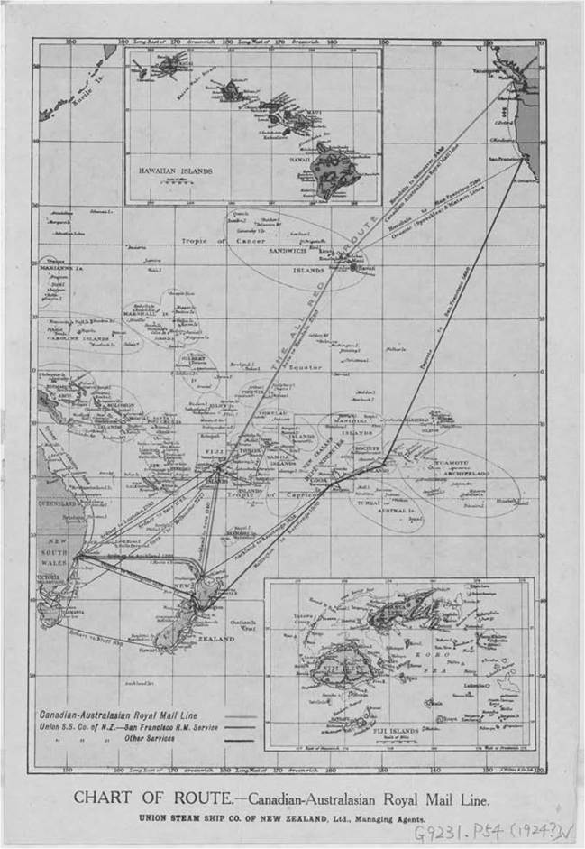
Map 21.1 Chart of route: Canadian Australasian Royal Mail Line (Dunedin: J. Wilkie & Co., 1924), National Library of Australia, MAP G9231.P54, 5399854.
America was its closest rival. Its ocean tonnage tripled to 2.4 million in the same period, but the Civil War and a preoccupation with the terrestrial frontier meant the United States turned inwards, away from the ocean. The British merchant fleet continued to expand and made most effective use of industrial advances in shipbuilding. In 1890 it reached 10 million tons and almost doubled to 20 million by the eve of the First World War. This represented 60 per cent of the world’s tonnage.29
An important consequence of the First World War was the growth of the American fleet. Shipyards built up a production momentum during the war and American tonnage increased to 23 per cent of world tonnage, six and a half times its pre-war size. This accounted for 86 per cent of net increase in world tonnage between 1914 and 1921. The government-owned fleet was sold off to American citizens throughout the 1920s to revive existing shipping routes and to establish new ones. British tonnage, however, declined from 60 per cent of the world total to 27 per cent by 1936, largely due to war losses and requisitions.30 The interwar years, therefore, witnessed significant shifts in the relative positions of Britain and the United States. This was felt keenly in the Pacific.
American shipping interests had engaged in trans-Pacific trade to Australia intermittently from the 1860s. Its aging and slow vessels demanded a new level of investment in the interwar years. The Matson Steam Navigation Company, prominent from the 1880s in the trades between Hawai’i and California, absorbed the Oceanic Steamship Company in 1926 and assumed control of its trans-Pacific service between San Francisco and Sydney (run in competition with the USSCo.’s Royal Mail Line). The Matson Line was able to make use of an American loan fund of $250,000,000 (£50,000,000) for merchant shipbuilding under the terms of the Jones—White Act of 1928 which aimed to renew and modernise the American merchant fleet. The company also secured a contract for the carriage of mails between the United States, New Zealand and Australia at remuneration far higher than the Canadian Australian Line received.31
By the late 1920s, the USSCo. felt its trans-Pacific operations were at breaking point. It feared it would soon find the Americans a ‘dangerous and troublesome people’.32 Voyage results on the All Red Route for 1920—1925 indicated that, after charging depreciation, the loss exceeded £180,000. Earnings on each trip came from freight, passage money, subsidies and wine profit. Disbursements included wages and fuel (the most important single items), followed by victualling, washing, marine stores, repairs, customs dues, insurance, labour, claims, advertising and management. Crew were signed on Australian articles, with wages estimated as 125 per cent higher than if ships took out articles in Britain. ‘Of course, if the employees banked or invested their money or built themselves houses, the loss would not be so great’, the USSCo. managing director remarked privately, ‘but I fear that only a small proportion of these increases is handled by the quiet, thrifty people’.33 The average cost of running the steamship Niagara was £43,700 per voyage, while its sister ship the Aorangi cost about £1,000 per day to run, an ‘indication that we have got into really big business, and expenditure under every head should be most carefully scrutinised’.34 The subsidies granted were inadequate to even offset the losses being incurred.
In the depths of the Great Depression, Matson launched two 20-knot ships, advertised as the ‘new sovereigns of the Pacific’. In the preceding decade the Canadian Australian Line had carried three-fifths of the passenger traffic between Australia and North America. Within three years of the appearance of its new ships, subsidised to the equivalent of about £14,000 per trip, Matson gained three-fifths of the traffic, leaving only one-fifth to each of the British routes.35 The other problem was that the American company was perceived to have encroached on an ‘all British’ domain by interposing a call at Auckland between San Francisco and Sydney from 1931, having already instituted a call at Suva from 1925. Yet America continued to restrict foreign companies from shipping between Honolulu and San Francisco.
With the onset of the Depression, the reduction in world trade and the rise of serious American competition, the USSCo. decided that the future of the All Red Route depended upon greater integration with the Canadian Pacific Railway Company (CPRCo.). It acquired a half interest in the line in 1931 and the headquarters relocated to Vancouver, although day-to-day management continued to reside with the USSCo. In the face of ongoing losses the Canadian Government increased its subsidy from $100,000 in 1934 to $300,000 (£40,000) by 1936. On the Sydney—San Francisco route the USSCo. incurred losses of about £50,000 per year. It received £34,500 in state support as compared to Matson’s £200,000.36 By 1936 the USSCo. felt it had no option but to terminate the Royal Mail Line. In effect, the Canadian Australian Line represented the last of British shipping across the Pacific.
America’s ‘uneconomic competition’ and its encroachment on the ‘purely British trade’ between New Zealand and Australia agitated the highest players in British shipping circles. This became known as ‘the Pacific problem’, the domain where imperial shipping was most under threat. The chairman of P&O, Britain’s premier shipping company, remarked that the problem stretched ‘beyond the mere interests of any commercial concern, or the economic loss involved to this or that Dominion... it goes to the roots of our Imperial position’.37 Britain needed its mercantile marine ‘to meet the stark necessities of our insular position and to preserve the economic existence of our sea-sundered Empire’. America, by contrast, could source all of its necessities and luxuries within its own territory. Britain had ‘earned’ the sea ‘by efficiency’. America acted out of vanity, usurping the sea ‘by every device which restrictive legislation and lavish expenditure can devise’.38 If the Canadian Australian Line was also abandoned ‘an example will have been given to other lands of how easy it is to extinguish British Lines anywhere, and of how British hesitation, timidity and inaction lend themselves to that process’.39 The route was regarded as a crucial test case, a barometer of the health and longevity of the British maritime empire.
In 1936 a report by the Imperial Shipping Committee (ISC) presented a detailed and sweeping account of the competitive difficulties Britain faced in trans-Pacific shipping following the intensification of American commercial maritime activity in the region. The ISC was established in 1920 as an advisory body to assist trade by investigating and overseeing imperial shipping facilities and needs. Much of its work centred on investigating complaints made by the dominions about the inadequacy of existing shipping services between them and Britain.40 The report made some important distinctions between the Pacific trade and other empire routes. There was no significant emigrant traffic ‘since there are new countries at either end’. Nor was there significant movement of government officials and families as was the case between India and Great Britain. The people travelling between western Canada and Australasia were predominantly businessmen and tourists, and the tourists ‘at any rate, need not go to sea unless they are attracted there’.41 More passengers chose the better Matson ships, which only carried first and second class, not third. While prospects for increased traffic between the coastal lands and islands of the Pacific appeared slim, the report concluded that the route was ‘of more than “Pacific” importance’. It represented ‘an alternative link in the system of round-the-world communications’ and ‘an alternative to Atlantic and Oriental cruising’.42
The interwar period was one of renewed imperial activity and attention to economic affairs born from wartime cooperation, as exemplified by the work of a number of new committees, conferences and marketing boards, including the ISC. Imperial trade increased greatly in the 1930s as Britain and the Dominions sought to insulate themselves from the effects of the Depression. British imports of Dominion produce— wheat, butter, cheese, fruit, eggs and meat—accounted for about half of Britain’s food consumption, and James Belich concludes that by 1939 ‘Greater Britain was at its peak economically and, possibly, culturally’.43 Yet this was not a trans-Pacific story. The Canadian Australian Line was never envisaged as a primary trade route between Australasia and Britain given the expense and trouble of two transhipment ports across Canada. Inter-dominion trade in the Pacific was not huge, for Canada, New Zealand and Australia produced similar products, although the alternation of seasons stimulated a trade in fruit and vegetables between them. The southbound cargo (Canada to Australia) was more than twice the volume of the northbound, while a significant lumber trade was conducted by tramp steamers rather than passenger liners. During the eleven years 1925—1935 the average receipts of the route were more than twice as much from passengers as from cargo. The high-class passenger traffic created the greater part of the revenue.44
Viewed from the perspective of this route, then, the Pacific was increasingly an ocean of first-class transit, an ocean of luxury and leisure. Ocean travel was no longer a necessity; purposeful sea travel gradually disappeared with the rise of tourism. Tourists had to be sold the sea. The maintenance of Britain’s maritime presence on the Pacific was still advocated on ‘grounds of sentiment and prestige’,45 yet it was the commercial standards of the ships themselves, the passenger experience and the redefinition of comfort at sea, rather than questions of strategy and defence, which were now at the fore. These themes were of only minor consideration in the late-nineteenth-century debates over the establishment of the All Red Route. The Pacific was also a high-cost ocean. Matson did not compete by cutting fares, but by ‘supplying “super” speeds and luxury’. As the ISC report concluded, ‘a standard has thus been set up exceeding the economic requirements and resources of the Pacific shorelands as at present developed’.46
The committee decided that an overhaul of operations was imperative, setting up a new company, launching a programme of new shipbuilding and altering the trans-Pacific route to include more port calls to increase revenue. A large shipbuilding loan was to be guaranteed by the British, Canadian, Australian and New Zealand Governments. Their twenty-year liability for interest and repayment was to be repaid proportionately, with Canada and New Zealand bearing the largest responsibilities, followed by Britain, Australia and Fiji. The total assistance package represented an annual increase of £140,000 over existing subsidies and mail receipts to the Canadian Australian Line.47
Australia was interested in supporting the new service (having terminated contributions to the All Red Route in the early twentieth century) on the condition that it was used as the base for the line and would thereby gain from additional expenditure on crew, repairs, stores and so on. Canada initially objected to the twenty-year loan guarantee term and was reportedly ‘not enthusiastic for an attempt to compete in the Pacific with the United States’.48 The project was eventually abandoned following the outbreak of war in 1939. The Line was suspended and merchant tonnage requisitioned for the war’s duration. The Canadian Australian Line resumed in 1948 but only as a one-ship, unsubsidised service. It continued its pre-war losing trend and when it was announced that the service would terminate in 1950, an assistance scheme was renegotiated by Canada, Australia and New Zealand. They recognised they could not support the service on economic grounds, but only to maintain a British flag vessel in the Pacific.49 Their subsidy was never enough to keep the ship in service and the Aorangi sailed across the Pacific for the last time in May 1953.
With the only regular trans-Pacific passenger service now by air (the Matson Line did not resume post-war trading until 1956), the British companies Orient and P&O felt compelled to enter the Pacific trades to ‘close a serious gap in Commonwealth sea communications’.50 Both had engaged in the Indian Ocean mail routes to Australia since the mid—late nineteenth century, but had never entered Pacific waters except for intermittent cruising between Australia and neighbouring Pacific Islands from the 1930s. In the 1960s the passenger trades were ultimately eclipsed by the jet age and the ocean liner became a marker of leisure travel, as it remains today.
Concluding thoughts
The movement for an integrated empire took hold from the closing decades of the nineteenth century, but saltwater barriers between Britain and its far-flung possessions created particular challenges. In a ‘sea-sundered’ empire, people attached special importance to the connecting links between them which British ships provided. Ocean transport, in short, as the P&O chairman proclaimed, was the ‘most vital possession of an Imperial people’.51
A shipping route between the colonies which bordered the Pacific Ocean represented the ‘last great link’ in the imperial chain. The political and commercial fortunes of the Canadian Australian Line, as charted here, illustrate that imperial networks have a material history in and of themselves. The developing historiography of the British World works to integrate historical experiences across settler communities. Looking more closely at the physical networks between them illustrates that these relationships were never ‘natural’ or a given, but had to be created and continually worked at. Lines across the sea were being mapped with increasing confidence and surety in the age of steam, yet they were not ‘reified and ossified infrastructures’, as Alan Lester reminds us, but rather dynamic processes—contingent and always in-motion.52
Shipping revealed the intimate relationship between political strategy, commercial activity and identity formations. Routes were relationships, engaging geographies of scale from the local and national, to the regional and imperial. Introducing and maintaining the Canadian Australian Line highlighted both the interdependence and the conflicting interests of different parts of the British Empire. The route was a perpetual topic of discussion and debate from the mid-nineteenth century through to its termination a century later. Who was prepared to pay for it? Which ports were to be included? What speeds were realistic? It was a delicate question of balancing and negotiating patriotic and commercial standpoints, and government and private enterprise.
The metaphors of the wheel and the web were developed and applied by historians with particular reference to nineteenth-century imperial spatial formations. In the twentieth century, new centres of gravity outside of empire emerged. The growing maritime supremacy of the United States in the Pacific Ocean increasingly left Britain on the periphery. The All Red Route was initially conceived to bring the Australasian colonies within three weeks of London; by the interwar years its fortunes were being debated without specific reference to the transatlantic passage or the ties between metropole and colony. The Pacific, in effect, became an arena where seismic shifts in global power relations played out, through the image and symbolic power of the ship itself.
Notes
1 The author is grateful to Julia Martinez and Georgine Clarsen for commenting on earlier versions of this chapter.
2 Tony Ballantyne, Orientalism and Race: Aryanism in the British Empire (Houndmills, 2002), pp. 13-17.
3 Daniel Headrick, The Tools of Empire: Technology and European Imperialism in the Nineteenth Century (New York, 1981); Headrick, The Tentacles of Progress: Technology Transfer in the Age of Imperialism, 1850-1940 (New York, 1988).
4 Matt K. Matsuda, Pacific Worlds: A History of Seas, Peoples, and Cultures (Cambridge, 2012), pp. 2, 3.
5 S.G. Sturmey, British Shipping and World Competition (London, 1962), p. 30; Michael Stammers, ‘Ocean Passenger Companies’, in John B. Hattendorf (ed.), The Oxford Encyclopedia of Maritime History, Vol. III (Oxford, 2007), p. 648.
6 Geoffrey Blainey, The Tyranny of Distance: How Distance Shaped Australia's History (Melbourne, 1977); Frank Broeze, ‘Distance Tamed: Steam Navigation to Australia and New Zealand from its Beginnings to the Outbreak of the Great War’, Journal of Transport History, Vol. 10, No. 1 (1989), pp. 1-21.
7 For intercolonial rivalries in early debates, see Keith Sinclair, ‘Australasian Inter-government Negotiations 1865-80: Ocean Mails and Tariffs’, Australian Journal of Politics and History, Vol. 16, No. 2 (1970), pp. 151-176.
8 Proceedings of the Colonial Conference, 1887 (London, 1887), pp. 12-13.
9 Ibid., p. 13.
10 South Australia Advertiser, 16 February 1886.
11 Proceedings of the Colonial Conference, 1887, p. 85. For ‘ocean of the future’, see Proceedings of the Colonial Conference 1894 (Ottawa, 1894), p. 231.
12 The Times, 4 October 1887.
13 Argus, 18 November 1887.
14 Otago Daily Times, 7 December 1897.
15 The Times, 24 January 1894.
16 Chronicle, 6 April 1901; G.R. Henning, ‘Huddart, James (1847-1901)’, Australian Dictionary of Biography, National Centre of Biography, Australian National University, http://adb.anu.edu.au/ biography/huddart-james-3809/text6043 (accessed 27 November 2012).
17 Fiji Times, 3July 1895.
18 Hawera and Normandy Star, 18 April 1899.
19 Minutes of Proceedings of the Colonial Conference, 1907 (London, 1907), pp. 573-574.
20 Evening Post, 16 November 1906.
21 See variously: Argus, 13 February 1886; The Times, 16 May 1893; Colonist [Victoria], 9 June 1893; Sydney Morning Herald, 25 February 1903.
22 John Macaulay, The All Red Route. Some of its Objects and Advantages to Empire (London, 1908), p. 7, p. 9.
23 The Times, 18 December 1907.
24 The Times, 25 December 1907.
25 Robert W.D. Boyce, ‘Imperial Dreams and National Realities: Britain, Canada and the Struggle for a Pacific Telegraph Cable, 1879-1902’, English Historical Review, Vol. 115, No. 460 (2000), pp. 39-70.
26 The official name of the route changed to ‘Canadian Australasian Line’. I continue to refer to it as the ‘Canadian Australian Line’ here.
27 National Archives of Australia, Melbourne branch, MP273/1/0, 1910/3791, ‘All Red Route’ Report of R.M. Coulter re his negotiations, pp. 7, 8.
28 The Scenic Route to Australia & New Zealand across Canada by Canadian National Railways (n.d.), pp. 1516.
29 James Belich, Replenishing the Earth: The Settler Revolution and the Rise of the Anglo World, 1783-1939 (Oxford, 2009), p. 111; David J. Starkey, ‘Economic History’, in The Oxford Encyclopedia of Maritime History, Vol. I, p. 622.
30 Walter Radius, United States Shipping in Transpacific Trade, 1922-1938 (New York, 1968), pp. 156, 159; The Times, 11 December 1935.
31 J.H. Hamilton, ‘The “All-Red Route”, 1853-1953: A History of the Trans-Pacific Mail Service between British Columbia, Australia and New Zealand', British Columbia Quarterly, Vol. 20 (1956), pp. 91-92; The Times, 2 July 1936.
32 Hocken Collections (hereafter HC), USSCo. Records, AG-292-005-002/021, Aiken, 14 January 1929.
33 HC, USSCo. Records, AG-292-005-002/018, Holdsworth to Prime Minister, 27 January 1928; AG-292-005-002/018, Holdsworth to Aiken, 18 February 1927.
34 HC, USSCo. Records, AG-292-005-002/020, Accountant to General Manager, 29 July 1927; AG-292-005-002/023, Holdsworth to Aiken, 3 March 1926.
35 In 1935, the total trans-Pacific passenger traffic between Australia and North America was 9,500. Thirty-fifth Report of the Imperial Shipping Committee, The Possibilities of a British Passenger and Cargo Service Between Western Canada and Australia-New Zealand (London, 1936), p. 14.
36 The Times, 2 July 1936; The Times, 16 April 1936.
37 Caird Library, P&O/6/27, Report of the Proceedings of the 95th Ordinary General Meeting of the Proprietors, 11 December 1935, p. 31.
38 Caird Library, P&O/6/27, Report of the Proceedings of the 93rd Ordinary General Meeting of the Proprietors, 6 December 1933, pp. 17, 39.
39 Caird Library, P&O/6/27, Report of the Proceedings of the 96th Ordinary General Meeting of the Proprietors, 9 December 1936, p. 19.
40 For a comprehensive history of the committee, see Kevin Burley, ‘The Imperial Shipping Committee', Journal of Imperial and Commonwealth History, Vol. 2, No. 2 (1974), pp. 206-225.
41 Imperial Shipping Committee, Possibilities of a British Passenger and Cargo Service, p. 19.
42 Ibid., p. 30.
43 Belich, Replenishing the Earth, pp. 470-471.
44 Imperial Shipping Committee, Possibilities of a British Passenger and Cargo Service, pp. 13, 16-18.
45 nAa, Canberra branch, CP42/67, Trans-Pacific Shipping Services, Board of Trade, ‘For the information of His Majesty's Governments in Canada, Australia and New Zealand', 21 January 1937.
46 Imperial Shipping Committee, Possibilities of a British Passenger and Cargo Service, p. 30.
47 NAA, Trans-Pacific Shipping Services.
48 National Archives Kew, CP 313 (37), CAB 24/273/38, ‘Cabinet. British Liner Communication across the Pacific', 17 December 1937.
49 National Archives of New Zealand, T1-303-47/246, Department of External Affairs, Memorandum ‘Aorangi', 2 June 1950.
50 The Times, 12 May 1953; Caird Library, OSN/13/8, Pacific 1954.
51 Caird Library, P&O/6/27, Report of the Proceedings of the 93rd Ordinary General Meeting of the Proprietors, 6 December 1933, p. 40.
52 Alan Lester, ‘Imperial Circuits and Networks: Geographies of the British Empire', History Compass, Vol. 4, No. 1 (2006), p. 134.
Further reading
Blainey, Geoffrey, The Tyranny of Distance: How Distance Shaped Australia's History (Melbourne, 1977). Gorman, Daniel, Imperial Citizenship: Empire and the Question of Belonging (Manchester, 2006).
Harcourt, Freda, Flagships of Imperialism: The P&O Company and the Politics of Empire from its Origins to 1867 (Manchester, 2006).
Headrick, Daniel, The Tools of Empire: Technology and European Imperialism in the Nineteenth Century (New York, 1981).
Jackson, Gordon, and David M. Williams (eds), Shipping, Technology and Imperialism (Brookfield, VT, 1996).
Killingray, David, Margarette Lincoln and Nigel Rigby (eds), Maritime Empires: British Imperial Maritime Trade in the Nineteenth Century (Suffolk, 2004).
Matsuda, Matt K., Pacific Worlds: A History of Seas, Peoples, and Cultures (Cambridge, 2012).
Perry, John Curtis, Facing West: Americans and the Opening of the Pacific (Westport, CT, 1994).
Steel, Frances, Oceania under Steam: Sea Transport and the Cultures of Colonialism, c.1870-1914 (Manchester,
2011).
Sturmey, S.G., British Shipping and World Competition (London, 1962).
More on the topic 21 LINES ACROSS THE SEA:
- Located northeast of the Mediterranean Sea, the Black Sea is different from its bigger neighbour, whose sky and water are famed for their hues of blue. Except for days of bright sunshine,
- COOPERATION ACROSS SECTORAL LINES
- The Sea of Japan/Korea’s East Sea
- Islamist opposition and shari'a 'red lines'
- DRAW-DOWNS/REMAINING PRINCIPAL/FACILITIES AND CREDIT LINES
- The disputes we have discussed in chapter 2 do not draw the lines youd initially expect.
- Article 7.2 Bulgaria lines up ˆ3.5bn bond issues as crises ease
- Introduction: A Sea with Many Names
- THE SEA OF DEATH
- Discovering the Red Sea
- Acting upon the landscape: the Dead Sea as a colonial resource
- Medieval and Modern Notions of the Baltic Sea
- The Coral Sea