Transportation and War
Like the Roman and Inka empires, the Khmer Empire was held together by an extensive network of roads. Archaeologist Mitch Hendrickson[1249] has determined that construction of such a system had begun as early as the seventh and eighth centuries, even before the founding of the empire.
By the reign of Jayavarman VII there were over 1,000 kilometers (600 miles) of raised earthen roads radiating from the capital, Angkor. The longest, the Northwest Road (the “Royal Road” of Andre Malraux's 1930 adventure novel) crossed the Dangrek Range, passed through Phnom Rung, and ended at the great site of Phimai (ancient Vimaya), in modern Thailand. Sdok Kok Thom (of the famous SKT inscription) was reached from Angkor by a western road. Another route ran northeast as far as Vat Phu in Champassak (southern Laos), with a shorter road branching off it due east to Preah Khan of Kompong Svay; and finally, the Southeast Road to Sambor Prei Kuk, much of which is yet in use as National Route 6, connecting Siem Reap with Phnom Penh (see Map 15.2).Within an approximate radius of 150 kilometers (90 miles) from the capital, the ancient Khmer constructed numerous laterite bridges supported by corbel arches to span watercourses. The one known today as Spean Prap Tos is 160 meters (525 feet) long, and still carries a two-way traffic of buses and heavily laden trucks—and thus in earlier times was fully able to withstand the passage of the largest war elephants.
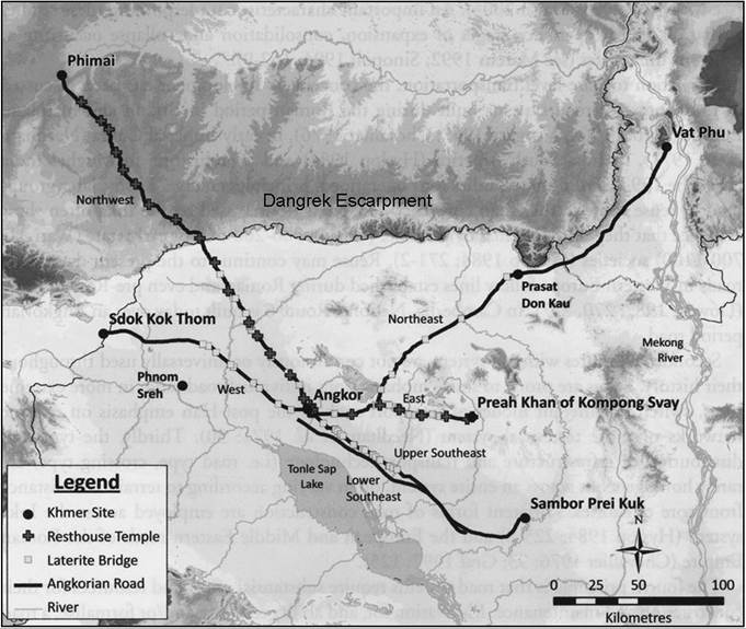
Map 15.2. Development of the Khmer Road System, Ninth and Thirteenth
Centuries CE.
Source: Hendrickson, 2010, “Historic Routes to Angkor, Development of the Khmer Road System (Ninth and Thirteenth Centuries AD) in Mainland Southeast Asia,” Antiquity 80, no. 324: 482. Copyright: Mitch Hendrickson.
These roads also blocked off various drainage channels, creating artificial reservoirs that held drinking water for both humans and their animals; since an Indian elephant requires impressive amounts of water per day, these were a military necessity.
Hendrickson has shown how these roads could have been used for the transport of armies and military supplies during documented conflicts between the Angkor state and foreign entities, and even during Khmer rebellions. These included campaigns against the Chams of Champa, and the Vietnamese of Dai Viet.
More on the topic Transportation and War:
- Defining convict transportation
- 9. Transportation
- The imperial scale and reach of penal transportation
- ‘Roman way of war' in the title of this chapter is a variant of ‘Western way of war', the theory first articulated by Victor Davis Hanson that has been the subject of much critique, and which I do not accept.1
- CHAPTER 9 The War at Home: Toys, Media, and Play as War Work
- From European war to World War
- Capabilities for War and Operations Other than War
- during the russian-ukrainian war, which began in early 2014 and was somewhat misrepresented in Western media as a kind of Ukrainian “civil war,” rather than a Russian invasion, there emerged a number of supposedly new images of Ukrainian warriors.
- 50 War and Peace, and More War
- The state made war but war did not make the state
- No one is fool enough to choose war instead of peace—in peace sons bury fathers, but in war fathers bury sons.—King Croesus of Lydia (Herodotus I: 87)
- War or Just War
- Cold War Divisions
- WAR AS A SOVEREIGN RIGHT