The Slavs and the Khazars
The origins of the Slavs
The origins and early development of the Slavs are, like those of other peoples, clouded in uncertainty. The few written references to the Slavs from the earliest period, together with extensive archaeological evidence uncovered in the nineteenth and twentieth centuries, are still insufficient for modern scholarship to provide conclusive answers to many thorny questions concerning their origin, location, way of life, and sociopolitical organization.
The written evidence about the early Slavs is scanty and consists of little more than brief descriptions of them by the Greek historian Herodotus in the fifth century bce and by Byzantine (Procopius) and Gothic (Jordanes) historians in the sixth century ce. Moreover, despite the best efforts of some scholars, the link between the growing body of archaeological data from these early centuries and any particular tribe of people is still a matter of speculation. The only thing that seems certain is that the Slavic peoples and their Proto-Slavic ancestors were present in eastern Europe from at least the first millennium bce. Precisely where in eastern Europe the Slavs had their origin is a question that will probably continue to remain a topic of debate among specialists.The current consensus suggests that the original homeland of the Slavs was located somewhere north of the Carpathian Mountains within a territory stretching from the upper Oder River valley in the west through the upper Vistula and Buh Rivers on to the middle Dnieper River in the east. In modern terms, this means that the original Slavic homeland included some parts or all of central and eastern Poland, southern Belarus, and northwestern Ukraine.
In terms of geography, the Slavic homeland was clearly north of the line that divided the mixed forest-steppe zone from the open steppe farther south - a line that ran diagonally across Ukraine from the lower Prut and Dniester Rivers in the southwest to the upper Donets’ River in the northeast.
In the mixed forest-steppe zone north of that line, the sedentary agricultural Slavs found a modicum of protection from the aggressive nomadic peoples of the open steppe.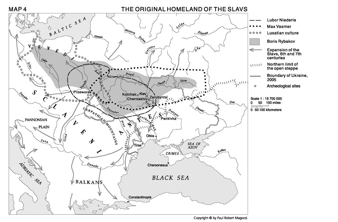
The Original Homeland of the Slavs
Among the first historical accounts to define the original homeland of the Slavs is the early medieval Rus’ Primary Chronicle (Slavonic: Poviest’ vremennykh liet). It states that the Slavs first “settled beside the Danube, where the Hungarian and Bulgarian lands now lie,” that is, along the middle and lower Danube valley, from the Pannonian Plain to the Black Sea. This view was accepted for many centuries, but later was replaced by the so-called Sarmatian theory, which considered the Slavic homeland to be on the Don River, thereby placing the Slavs in close relationship with the Iranian Scythians and Sarmatians. In the nineteenth century, scholars began to argue that the original Slavic habitat was either in the Carpathian Mountains or farther north, along the marshes of the Pripet River. Today, four views are current.
(1) The Czech archaeologist Lubor Niederle (1902) defined the Slavic homeland as centered in northwestern Ukraine, encompassing the upper Vistula and Buh valleys, the Pripet Marshes, and Right Bank Ukraine bounded by the Dnieper River in the east and the crest of the Carpathians in the south.
(2) The Slavic linguist Max Vasmer (1941) fixed the Slavic homeland somewhat farther east, centering it in north-central Ukraine where the Pripet and Desna Rivers meet the Dnieper. This territory includes, in the west, the Pripet Marshes and Right Bank as far as the upper valley of the Southern Buh River, and, in the east, the region of the upper Donets’ and upper Don valleys.
(3) Several interwar and postwar Polish archaeologists - Jan Czekanowski, Tadeusz Lehr-Splawinski, Leon Kozlowski, Jozef Kostrzewski, and Tadeusz Sulimirski - argued that the original Slavic homeland coincides with the area of the so-called Lusatian culture, which, on the evidence of archaeological finds, they identified as having been located between the Elbe River in the west and the Buh River in the east, and as spreading from the crest of the Carpathians northward all the way to the Baltic Sea.
This territory coincides largely with the present-day boundaries of Poland.(4) Post-World War II Soviet archaeologists (Petr N. Tret’iakov, Boris Rybakov), joined by Polish (Konrad Jazdzewski) and Czech archaeologists (Jan Filip, Jiri Horak, and Zdenek Vafia), argued that the area of Lusatian culture was only one part of the Slavic homeland, and the westernmost one at that, and that the territory should therefore be extended eastward as far as the lower Desna and Seim Rivers.
Whereas their emphases may differ slightly, modern scholars seem to maintain the common premise that the original homeland of the Slavs was north of the Carpathian Mountains and north of the line that divided the mixed foreststeppe from the open steppe. This territory extended from the upper reaches of the Oder River in the west across to the middle Vistula, Buh, Pripet, middle Dnieper, and Desna Rivers in the east; in contemporary terms, it was made up of north-central and western Ukraine, southwestern Belarus, and south-central and southeastern Poland.
The migrations of the Slavs
By the middle of the first millennium bce, the Slavs had begun to move slowly in various directions from their original homeland. This gradual process of outward migration was to last a millennium. It was especially pronounced toward the south, into the middle Dniester and Southern Buh valleys of southwestern Ukraine. The Slavs and, for that matter, other peoples were drawn to Ukraine because of its natural wealth and the possibility for trade with the Greek and, later, Roman cities along the coasts of the Black Sea and Sea of Azov.
It was inevitable that the Slavs would come into contact with the nomadic and semi-sedentary civilizations that held sway over Ukrainian territory. This was the case with the Scythians, who after 750 bce controlled the steppe area north of the Black Sea. It seems that the agriculturalists and certain that the so-called ploughmen of Scythian society were at least to some degree made up of Slavs.
The subordinate position of the Slavs at first was maintained under the Sarmatians, who displaced the Scythians after 250 bce.Information about the Slavs on Ukrainian territory during the Sarmatian era comes from the sixth-century Goth and Byzantine historians Jordanes and Procopius. They were the first writers to describe the Slavs in any detail. Jordanes divided them into three groups: (1) the Venedi, living along the Baltic Sea and the lower valleys of the Elbe, Oder, and Vistula Rivers; (2) the Antae, living along the Black Sea between the Prut and the Southern Buh Rivers; and (3) the Sclaveni, living north of the Danube, in both Moravia and the Carpathian Basin as well as in Walachia and Moldavia. The second of these groups, the Antae, are of particular interest with respect to the developments in Ukraine.
The Antae
Because of the limited and conflicting written evidence (in contrast to Jordanes, Procopius does not classify the Antae as Slavs) and the inconclusive nature of archaeological data, there remains much controversy about the Antae (Ukrainian: Anty). It is agreed that their presence derives from the Sarmatian era. The most important Sarmatian tribe on Ukrainian territory were the Alans, and one group of the Alans were known as the Antae. It seems that after their arrival in the Ukrainian steppe during the first two centuries ce, the Alanic Antae (like other Sarmatian tribes of Iranic origin) began to organize the Slavic and other tribes living in their midst. Initially centered on lands between the Prut and the lower Dniester Rivers during the fourth century ce, the Antaen power base moved progressively northward: first to the upper valley of the Southern Buh; then, in the fifth and sixth centuries, to Volhynia; and later to the middle Dnieper region. Eventually, as they moved farther north beyond the open steppe into the more heavily Slavic-populated areas, the name Antae came to be used for the upper echelons as well as the Slavs under their control.
At the same time, the Slavs themselves gradually replaced the original group of Irano-Alanic conquerors and military elite from whom they had acquired the Antaen name.By the fourth century ce, the Antae had evolved into a powerful tribal league with effective military units. Their reputation as a potent fighting force was still evident in the sixth century, when Jordanes described them as “the bravest of these peoples dwelling in the curve of the Sea of Pontus [Black Sea], spread from the Dniester to the Dnieper.”1 The Antae were able to undertake successful raids against the Byzantine Empire and to resist the Goths, who after 250 ce had established a power base in the Crimea and southern Ukraine. It is from the Gothic- Antaen conflicts that descriptions of powerful military leaders like the fourth-century Antaen “king” Boz have come down to us.
The fifth century marked the apogee of Antaen power on Ukrainian territories. At that time, the Antae were able to fill a power vacuum that had been left in the region west of the Dnieper River. This occurred after the Gothic supremacy in the area was undermined by the Huns in the late fourth century during the latter’s westward advance across Ukraine toward the Pannonian Plain beyond the Carpathian Mountains. Within the Antaen sphere, based in north-central and northwestern Ukraine, a sedentary civilization consisting of numerous villages in which agriculture and cattle breeding were the primary occupations came into being.
The sedentary Antae also established several hill forts, known as horodyshcha or horody, where artisans produced metalwares and pottery. Remnants of these items have been uncovered by archaeologists, who describe their findings as belonging to what they call the Cherniakhiv and Pen’kivka cultures. Among the more important of the fortified centers were Volyn’ in the far west and Kiev along the middle Dnieper, from which the Antae carried on a brisk local and international trade reaching the markets of the Roman and Byzantine empires.
Whereas the existence of the Antae somewhere on Ukrainian territory between the third and seventh centuries is recognized, the nature of their society and the extent of their rule remain a source of controversy. Some scholars believe the Antae were Slavic or partly slavicized tribal groups who from time to time were able to join together to create tribal leagues with their own military forces. Others suggest that the Antaen tribal league evolved into “statehood,” which would make them the creators of one of the earliest Slavic states. Francis Dvornik even speaks of an Antaen “empire” stretching virtually the full extent of the original Slavic homeland from the Oder River in the west to the upper Donets’ and Oka Rivers in the east. Most writers, however, limit the Antaen sphere to the East Slavs: non-Soviet Ukrainian authors (Hrushevs’kyi, Polons’ka-Vasylenko) consider them creators of the first Ukrainian state; Soviet authors (Grekov, Rybakov) see them as an indigenous Slavic group who formed the first East Slavic state, based in the sixth
Archaeology in Ukraine
Historical accounts frequently describe the first period of Ukrainian history or prehistory (ca. 1150 bce to ce 850) in terms of the succession of nomadic peoples, from the Cimmerians to the Khazars, who invaded Ukrainian territory and controlled it for varying periods of time. Archaeological accounts, however, describe these same two millennia, as well as previous eras, in terms of cultures whose characteristics are arrived at on the basis of the remains found in archaeological digs. Such remains include dwellings, household implements, military equipment, burial sites, coins, and, especially, pottery. These archaeological data tell us more about the material way of life of the sedentary agricultural population than do the scattered accounts by classical authors, who at best left sketchy descriptions of the ruling nomadic peoples.
Archaeologists have uncovered the presence of more than one culture on Ukrainian territory during any given period. These cultures, moreover, may have been geographically displaced and may have lasted longer in a new place than in their places of origin. The names given to the cultures frequently are derived from sites where the first archaeological discovery was made in the late nineteenth or early twentieth century (Trypillia, Zarubintsiv, Cherniakhiv) or from the style of the pottery (shnurova “line”) or burial pattern (catacomb) adopted by the given culture.
Many cultures from the prehistoric and historical eras have been distinguished by archaeologists on Ukrainian territory. Among the best known are the Trypillian culture (ca. 4500-2000 bce), which witnessed the transition from nomadic pastoralism to sedentary agriculture; the Bilohrudivka culture (1350-800 bce), which coincided in part with the Cimmerian presence; and the Srubna culture (1200-600 bce), toward the end of which the Scythians made their appearance.
By the beginning of the common era, several new cultures had emerged, although there is on-going debate among scholars whether archaeological finds can be classified and then related to specific historical cultures and peoples. The problem of relating archaeology to history is particularly marked with regard to the ethnogenesis of the Slavs.
The first of these new cultures was the Zarubynets’ (named for a site near Pereiaslav), which flourished from about 200 bce to ce 200, particularly in northwestern (Volhynia and the Pripet Marshes) and north-central (the Kiev region) Ukraine. This culture was that of an agricultural people living in small dwellings along protected banks of rivers. They were noted for excellent iron production. The Zarubynets’ culture coincides with the Sarmatian period, although it probably included several peoples (Baltic, Scythian, Pomeranian), of whom the Slavs may have been one.
In about 200 ce, the so-called Cherniakhiv culture (named for a burial ground near Kiev discovered in 1899 by V. Khvoika) emerged in both the mixed foreststeppe and open steppe geographic zones covering most of Ukraine, Moldova, and eastern Romania. This area included hundreds of settlements scattered in narrow strips, sometimes nearly two-thirds of a mile (one kilometer) in length, along river banks. Gray or black polished pottery, iron tools, and metal ornaments of a high standard are associated with the Cherniakhiv culture, and, as is evident from remains, the inhabitants of the settlements also carried on trade with the Roman world to the south. Their spiritual life is revealed through several stone statues of pagan idols, three to ten feet (one to three meters) in height, found at various sites in the middle Dniester River valley and dating from the second to the fifth century. Scholars disagree as to what tribal groups created the artifacts related to Cherniakhiv culture, although it seems to be the result of several, including the Dacians, Sarmatians, Germans, Scythians, and Antae. Whatever its ethnic composition, the Cherniakhiv culture seems to have come to a sudden end around 400 ce, probably the victim of the invasion of the nomadic Huns.
Almost simultaneously with the Cherniakhiv culture arose the Pen’kivka culture (named for a site near the middle Dnieper River now under the Kremenchuk reservoir), which was initially based in the region between the Dnieper, Southern Buh, and lower Dnieper Rivers. The Pen’kivka culture seems to have represented the remnants of the Sarmatian presence in Ukraine, whose Iranian inhabitants had become slavicized and who were later described in historical records as the Antae. This agriculture-based culture was marked by small settlements along river banks, made up of semi-subterranean dwellings, each with a stone oven. The Pen’kivka culture associated with the Antae flourished from the fourth century ce until the Avar invasion of the early seventh century. The Avars may have reduced the power of the Antae’ military forces, but they did not destroy the way of life characteristic of the Pen’kivka culture, which continued to survive, especially in northwestern and north-central Ukraine.
century among the Dulibians in Volhynia and in the seventh and eighth centuries among the Polianians in the middle Dnieper region near the Ros’ River.
Whether the Antae created a state structure or existed simply as tribal groupings, their influence was broken after the arrival of the Avars during the second half of the sixth century. With the Avar presence, the Antae disappeared; they are last mentioned in historical sources at the beginning of the seventh century (602).
The Pax Chazarica
Aside from the disappearance of the Antae, the seventh century proved to be an important turning point in the history of Ukraine. By the middle of that century, the warlike Avars had moved out of Ukrainian lands and westward across the Carpathians into the Pannonian Plain, while a new Turkic people, the Khazars, were
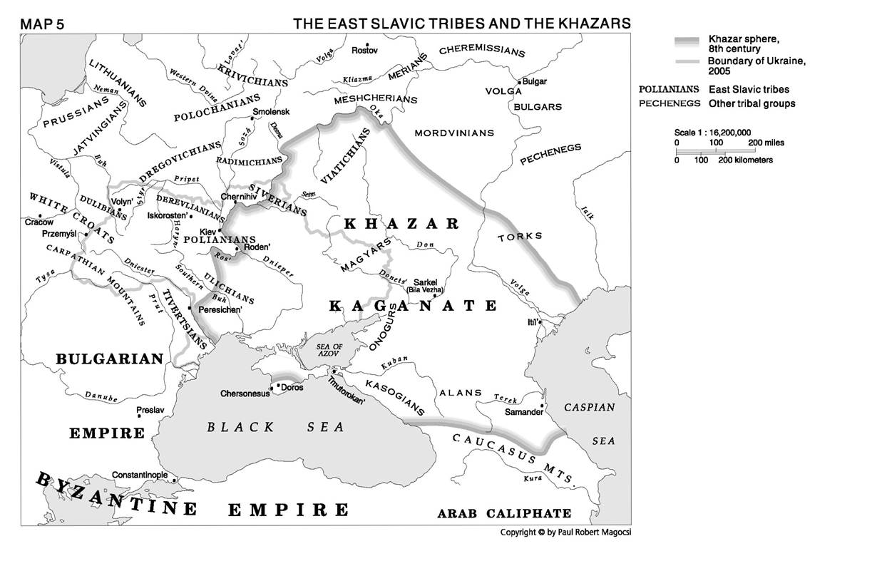
establishing a powerful political and commercial center just east of Ukrainian territory between the lower Don, lower Volga, and Kuban-Terek River valleys. As for the East Slavic tribes, some went west beyond the Carpathians with the Avars. In Ukraine, the Dulibian tribal union in Volhynia dissipated and was replaced by a new tribal union among the Polianians and Siverians along the middle Dnieper valley. Scholars maintain either that the Polianian-Siverian union, with centers such as Roden’, at the conjunction of the Ros’ and Dnieper Rivers, continued the tradition of East Slavic statehood (Soviet authors spoke of an early Rus’ state in this region), or that it functioned as a tribal unit within the Khazar sphere.
The Khazar sphere was concentrated within the triangle formed by the lower Don, lower Volga, and Kuban-Terek Rivers. But Khazar influence was felt far beyond as well. By the early ninth century, several East Slavic tribes to the northwest (the Polianians, Radimichians, Siverians, Viatichians), and other peoples, including the Mordvinians, Cheremissians, and Volga Bulgars in the north, and the Magyars, Onogurs, Kasogians, and Alans in the south, were all under the hegemony of the Khazar Kaganate, or empire. From the eighth century, the Khazars also controlled much of the Crimea, where the Crimean Goths with their center at Doros came under their domination as well.
Within this vast territory were to be found some of the most lucrative international trading routes, especially the northern branch of the silk route from China, which passed the Aral Sea and skirted the northern Caspian Sea, ending in the Khazar capital of Itil’, near the mouth of the Volga. From Itil’, the Khazars traded southward across the Caspian Sea to Baghdad and the Persian, later Arab, Middle East, or westward down the Don River and across the Black Sea to Byzantium. Trade and commerce were of the greatest concern to the Khazars, and the control and protection of commercial routes was the highest priority of the empire’s military forces. Customs duties levied on goods passing along the trade routes under their control provided the main source of Khazar wealth, which was supplemented by taxes collected from various peoples under their hegemony. In return for this lord-vassal relationship, the Khazars provided peace and stability in the region as well as possibilities for trade. These were the main characteristics of the new order known as the Pax Chazarica.
Because of their interest in trade and commerce, the Khazars, unlike their nomadic predecessors and successors, preferred diplomacy and peace to war and plundering. Accordingly, in the north, even after the Volga Bulgars had become independent in the mid-eighth century, the Khazars maintained friendly relations with them. Toward the south, after a fierce struggle with the Persian Empire and, later, the Arab Caliphate during the seventh and eighth centuries, in about 750 the antagonists agreed it was useless to continue fighting. Both powers decided that the Caucasus Mountains should serve as their “natural” frontier.
Relations with Byzantium, the region’s major commercial emporium, were very favorable from the time of the initial rise of Khazar power in the seventh century. The Khazars served as allies of Byzantium, first against the Persians and later against the Arabs. The only potential threat to peaceful ties was in the Crimean Peninsula, where the Bosporan Kingdom had been under Byzantine hegemony since the sixth century. The Khazars built a fortress, Tmutorokan’, at the site of the Greco-Bosporan city Hermanossa (Tamatarcha), on the eastern shore of the Straits of Kerch. Taking advantage of civil strife between the Crimea and the Byzantine capital, the Khazars took control of most of the peninsula at the very end of the seventh century. It was not long, however, before the Khazars assuaged Byzantine fears. They agreed to divide the Crimea into a Byzantine sphere along the coast and a Khazar sphere in the hinterland behind the mountains.
Byzantine-Khazar relations were further strengthened in the eighth century by marital diplomacy (several Khazar princesses became wives of Byzantine emperors) and in the ninth century by a common defense against the increasingly restless nomadic Magyars and the newly arrived Varangian Rus’. The common defense took the form of the construction in the 830s by Byzantine architects of a second Khazar capital on the Don River at Sarkel (in Slavic, Bila Vezha) and the dispatch to the Khazars in the 860s of a “cultural” mission headed by the Byzantine Christian missionaries Constantine and Methodius.
The international commercial relations emphasized by the Khazars also transformed their empire into a fertile ground for cultural development, especially for religion. The Khazars were originally believers in Shamanism of the Altaic variety, but their ruling elite was receptive to other more advanced religions. In fact, all three great religions were received favorably by the Khazar leadership: (1) Islam, via Arab traders in the seventh century; (2) Judaism, via Jewish missionaries, among them Isaac Sangari in 767; and (3) Christianity, via Constantine and Methodius from Byzantium, the future “Apostles to the Slavs,” who lived in the Khazar capital of Sarkel in 860 and 861. Between 789 and 809, the Khazar ruler (kagan) and nobility embraced Judaism, and later, during the first half of the tenth century, the kaganate became a refuge for Jews fleeing persecution by the Byzantine emperor (Romanus Lecapanus, reigned 919-944). Although eventually the Khazar Kaganate was most influenced by Islam, it nonetheless is the only state in history to have converted to Judaism, for however brief a time. Its conversion has given rise to Jewish legend and to theories (the most recent treatment being Arthur Koestler’s The Thirteenth Tribe) adopted by various authors to prove that eastern Europe’s Jews are descendants of the Khazars.
The Khazars are important because for two centuries - ca. 650 to 850 - their state fostered stability within a wide region, one surrounded by several cultures, between the Black Sea, the Caspian Sea, and the Caucasus Mountains. While the Khazar Kaganate was never the kind of impenetrable “bulwark of the steppe” against the East that is often suggested in traditional literature, it nonetheless served as a power center around which nomadic tribes and federations (the Bulgars, Alans, Magyars, East Slavs) gravitated and in which they found it more advantageous to trade and to live in peace than to provoke war and conflict.
The Slavic tribes in the shadow of the Khazars
The Slavic inhabitants of central and southwestern Ukraine, protected by the Pax Chazarica, were able to move south along water routes as far as the Black Sea and to expand east of the Dnieper River. Out of the old Antae federation, several distinct Slavic tribes evolved on Ukrainian territory: the Siverians, in the northeast along the lower Desna and upper Seim and Sula Rivers; the Polianians (plains people), along the Dnieper River between Kiev and Roden’; the Derevlianians (forest dwellers), bounded by the Pripet and Horyn’ Rivers; the Dulibians, in Volhynia, along the upper valleys of the Vistula, Buh, and Styr’ Rivers; the White Croats, north of the Carpathian Mountains; the Ulichians, on the left bank of the Southern Buh River; and the Tivertsians, between the Dniester and Prut Rivers near the Black Sea.
As during the period of the Antaen tribal leagues, the centers for these various Slavic tribes were hill forts known as horodyshcha or horody. At first, these were no more than stockades encircled by moats and ramparts where the surrounding agricultural population came for protection in times of danger. Eventually, the horody became towns where artisans produced wares and merchants conducted trade. By the ninth century, there were an estimated 400 horody in the Kiev area, 350 in Volhynia, 250 in Podolia, and 100 in Galicia. Among the more important were Kiev, the center for the Polianians, founded by their semi-legendary leader Kii (ca. 560); Chernihiv, the center for the Siverians; Iskorosten’ (Korosten’), for the Derevlianians; Volyn’ (now Horodok, on the Buh), for the Dulibians; Przemysl, for the White Croats; and Peresichen’, for the Ulichians. Initially, the tribal organization was in the hands of representatives of those families who had secured positions of power and influence on the basis of wealth, military prowess, or personal qualities. These representatives met in a council (viche) to decide important issues, and from time to time the most powerful of them became leaders or princes for the tribal group as a whole.
The primary livelihood of the Slavic tribes was agriculture and cattle raising. They harvested several different grains, fished, hunted wild animals, and collected honey and wax from bees. These were some of the goods they traded in the horody, where artisans had well-developed pottery, weaving, and metal industries, especially in iron. Besides supporting local commerce, Ukrainian lands became an important component of the Khazar international trading network.
In the early centuries of Khazar rule, the major trade route connecting Central Asia, the Arab world, and Byzantium with northern Europe passed through the Khazars’ territory - Khazaria - up the Volga River, then crossed several lakes to the Gulf of Finland and the Baltic Sea (see map 6). The initiators of this northern trade were the Varangians, who, from their home base on the western shores of the Baltic Sea and outposts in northern (Staraia Ladoga) and northcentral (Rostov) Russia, began during the eighth century to descend the Volga River to Khazaria. By the ninth century, a shorter route, from the Baltic through several lakes and rivers directly southward to the Dnieper River on to the Black Sea and Byzantium, had been opened. Not wanting to be outdone by what later became famous as the great waterway “from the Varangians to the Greeks,” the Khazars strengthened their presence in the middle Dnieper with a garrison at Kiev, which in turn was connected by an east-west overland route to the Khazar capitals at Sarkel and Itil’. The result was that Kiev became the axis for major north-south and east-west trade routes along which goods flowed to and from Central Asian, Arabic, Byzantine, and Balto-Scandinavian markets. Along these and subsidiary routes, the East Slavic tribes in Ukraine exchanged their grain, wax, honey, and, sometimes, fur and slaves for fine cloth, gold, silver objects, wine, and pottery.
Although there were several Slavic tribes, they had much in common with regard to their basically agricultural way of life and their mythology or system of belief. Scattered in small groups across the vast plains and forests, the Slavs responded to their isolation and fear before the mysteries of nature by formulating divinities who peopled the clouds and the earth, the forests and the rivers, and their own fields and stables. In personifying nature, they were attempting to communicate with it in “human” terms and thereby to reduce the terror of the unknown. Since their system of beliefs is not set forth in a body of written texts, what we know of it derives from descriptions by antagonistic Christian writers and from latter-day folk customs that are presumed to retain remnants of pre-Christian Slavic mythology.
There seem to have been two categories of gods: major ones, who had control over the forces of nature; and minor ones, who inhabited local woods, fields, and rivers. The major gods included Svaroh, the sky, who gave birth to two children - Dazhboh, the sun, and Svarozhych, fire. Also of importance were Perun, the god of thunder, and Volos, the god of the animals. In the second, minor category were a whole host of spirits who inhabited forests (lesky), bogs (bisy), fields (pol’ovyky), and bodies of water (rusalky). Others were associated with human emotion, such as larylo, the god of springtime regeneration and sexual passion, and Kupalo, the god of water, herbs, and flowers with their purifying powers. Sacrifices were made and rituals performed in the service of all these gods.
In general, however, the system of belief among the Slavs was personal, with no temples, statues, or priests. There were two exceptions, however, found among Slavs on the island of Rügen in the Baltic Sea, and in Kiev. Both places had effigies of mythic gods. In Kiev, there was a large wooden statue of Perun, who as the personification of thunder became the god of war to whom Kiev’s earliest rulers and first Rus’ princes paid tribute, as they did also to Volos, the god of beasts, before going off to war. On the island of Rügen, the Slavic Ranians had an even more elaborate ritual and temple-like setting for their “god of gods,” Svantovit. Svantovit’s influence seemed to be widespread as well among West Slavic tribes north of the Carpathians, and an eight-foot (two-and-a-half-meter) statue believed to depict him was found in the mid-nineteenth century along the banks of the Zbruch River, in western Ukraine. With the coming of Christianity, the major Slavic gods and their statues were destroyed, but belief in the minor ones throughout rural areas remained strong - often flourishing through amalgamation with Christian beliefs - until as recently as the twentieth century.
Living within the protective shadow of the Pax Chazarica, the Slavic tribes on Ukrainian lands were spared for a while the worst nomadic invasions from the east, and, as a result, between the seventh and ninth centuries they were able to expand their agricultural and trading activities. But despite such protection, some Slavic princes began to resent their vassal-like relationship to the Khazar rulers. For the
The Slavs and the Khazars 51 longest time, however, the Slavs were not united, and no individual tribe had the strength to confront the Khazar Kaganate. Building up the necessary strength became a possibility only in the mid-ninth century, with a new development in the region of Kiev. This development combined local forces with a group of leaders from Scandinavia - the Varangians - and the result was the eventual consolidation of a new power known as Rus’. How did this new phenomenon arise? Or, to cite the opening passage of the Primary Chronicle, the most famous discussion of the subject, what was “the origin of the land of Rus’, [and of] the first princes of Kiev, and from what source did the land of Rus’ have its beginning?”2
This page intentionally left blank