41 Austrialia or Australia?
I
The idea that a great southern continent existed can be traced very far back in time. It has been seen that the Romans understood Ceylon to form the northern tip of this mysterious continent, in accordance with Ptolemy’s view that the Indian Ocean was an enclosed sea whose southern shores connected Africa and south-east Asia.
Even when it became obvious that Ptolemy was mistaken, the assumption that a southern continent existed led mariners sailing in the wake of Magellan to think that Tierra del Fuego was the tip of this southern continent. The sixteenth-century English circumnavigators, Drake and Cavendish, travelled through the Magellan Strait, but their explorations suggested that Tierra del Fuego was a large island; even when the route round Cape Horn was discovered, its high winds and violent seas long discouraged navigators. It was believed that the world needed to be in balance to occupy its position in the middle of the firmament. Therefore a southern land as weighty as the continents in the northern hemisphere must exist. Moreover, once one had crossed the torrid regions, where human survival had long been assumed to be impossible, one would find lands that were ‘as fertile and habitable as the northern hemisphere’, rich in precious stones, pearls and fine metals, as well as abundant flora and fauna. These lands were sometimes known as Magellanica, though this term was quite flexible, and could mean Pacific islands or even South America.1There was plenty of evidence towards which sixteenth-century geographers could confidently point: biblical texts, of which more in a moment; classical texts, culminating in Ptolemy’s world map; and also Peruvian legends of an Inca ruler named Tupac Inca Yupanqui who set out across the sea and discovered lands of great wealth; he supposedly brought back gold and slaves, as well as providing encouragement, centuries later, to the bizarre theories of Thor Heyerdahl about trans-Pacific navigation.
Although the first map to name America, by Waldseemuller, showed no southern continent, certainty that it existed grew in the next thirty years. Mercator’s first world map, from 1538, included a massive southern continent, of which he could only say: ‘that land lies here is certain but its size and extent are unknown’; however, its northern tip reached as far as the Magellan Strait, and when he issued a more famous world map in 1569 he had not changed his mind. When Abraham Ortelius published his own world map in 1570 he could not improve on this. For him this was the ‘Southern Land not yet known’, Terra Australis Nondum Cognita.2
The series of Spanish voyages across the Pacific that followed the Spanish capture of Mexico and Peru brought European ships deep into the Polynesian islands. In 1542, for instance, the commander Villalobos set out from Navidad, which lay along the Pacific coast of Mexico, a little to the north of Acapulco, searching for the islands visited by King Solomon - the distant land of Ophir mentioned in the book of Kings. The idea grew that the gold vessels of Solomon’s Temple had been made out of beaten gold from Ophir.3 Villalobos’s journey took his ships towards what therefore became known as the Solomon Islands, amid many hazards: a whale swam underneath the flagship, almost heaving the galleon out of the water before it swam on and the galleon rocked back to normal. In the event, the voyage ended up in the Philippines, and only the fringes of Polynesia had been penetrated. Back in Seville the notion that Ophir lay not somewhere in the Red Sea or western Indian Ocean but across the world in the southern Pacific had gained a certain amount of purchase; Columbus, in his Book of Prophecies, which was really a scrapbook of biblical, classical and patristic quotations, had been dreaming of finding Solomon’s islands by sailing west.
The learned introduction to a Spanish translation of Marco Polo’s book of travels, widely circulating by 1530, placed Ophir somewhere in that vast space between Japan and the Moluccas that was still a matter of pure conjecture. A series of Spanish voyages set out from 1567 onwards, looking for a great southern land, or rather for a series of islands that were believed, rather like the West Indies, to lie close to the unknown continent and to offer great riches. The spirit of scientific enquiry was clearly subordinate to the greedy search for gold and spices, though there may have been some hope of bringing the Catholic faith to heathen peoples. The whole enterprise was strikingly reminiscent of that of Columbus over seventy years earlier. As in the Americas, the assumption was that Spain would lay claim to this land, whether it was populated or not, and establish a colony there.The commander of the first expedition, Alvaro de Mendana, took his two ships on a conservative route out from Callao, in Peru, and then across a wide space of water until he reached what are now Tuvalu and the Solomon Islands. Mendana had to face the hostility of the islanders, and just as bad as that was the hostility of his colleague Sarmiento, a military man who had been pressing for the expedition to be launched, and resented being passed over as commander; Mendana was the viceroy of Peru’s nephew, though the viceroy hoped to use this expedition to send away many of the young adventurers who were clogging the streets of Callao. In the event, the ships carried a motley crew of Spanish, mixed-blood and African men, for slaves who had already crossed the Atlantic were arriving as far away as Peru.4 Sarmiento went along on the voyage, although his exact position on board is, and probably was at the time, unclear. Not much was achieved, apart from planting in Mendana’s mind an obsession with the southern continent and with the supposed riches of the islands he had visited. Mendana’s detailed report on his voyage was not entirely encouraging: the explorers had not always found it easy to obtain food, although they had managed to trade small amounts of truck with the islanders.
They had been taken aback by the evidence that the islanders consumed human flesh, not least when a friendly chieftain offered Mendana a piece of meat that he identified as the shoulder and arm of a boy (the hand was still attached). The islanders were taken aback when Mendana declined to eat the arm:I accepted the present, and, being greatly grieved that there should be this pernicious custom in that country, and that they should suppose that we ate it... I caused a grave to be dug at the water’s edge and had the quarter buried in his [the native leader’s] presence... Seeing that we set no value on the present, they all bent down over their canoes like men vexed or offended, and put off and withdrew with their heads bent down.5
Although the practice of both cannibalism and human sacrifice could be used as an excuse to justify European hegemony, the revulsion of the Spaniards was genuine. As Montaigne was aware, they forgot that their own form of human sacrifice, practised in the fires of the Spanish Inquisition, was in some respects comparable.6 Other types of food were hard to come by, and by the time they had returned to America they had even had to consume the white cockatoo which was, perhaps, the only prize they had obtained during their arduous journey.7
Unfortunately the new viceroy, Toledo, was much better disposed to Sarmiento and much worse disposed to Mendana than his predecessor, so Mendana trailed across the world to the court of King Philip II, to whom he had already written a Columbus-style letter exaggerating the attractions of the Solomon Islands. He did not secure what he wanted until 1574, and even then he had to learn patience on an unusual scale. He arrived in Panama a couple of years later, ready to launch his voyage into the unknown corners of the Pacific, armed with an exceptionally generous royal privilege. The king graciously permitted him to take office as governor and marquis of a new colony in the Pacific, with the right to pass these lands on to his heir, and to recruit a native labour force (for distribution among his followers).
He could even mint his own gold and silver coins, presumably out of metals mined by his new subjects - as if the tragic lessons of what had happened in Hispaniola had never been learned. He would be provided with sheep, goats, pigs, cattle and horses, as well as Spanish settlers, male and female. He would have to found three cities, though, and he had to post a bond of 10,000 ducats to make sure that he did not renege on his promises.8Drake’s entry into the Pacific in 1578 put a spoke in the wheels of Mendana’s ambitions. The Spaniards had assumed that the wide spaces of the Pacific east of the Spice Islands were Spanish waters, granted by the pope in his division of the world as long ago as 1494. Protestant English privateers had no place in this vast space. The priority became not the launch of a new expedition westwards across the ocean, but the despatch of an armed fleet southwards to prevent foreign ships from slipping into what was still an unguarded space. Sarmiento was sent to the Magellan Strait to bar the way to English shipping. Far from keeping the English out, he was taken prisoner and carried off to London, where he, Queen Elizabeth and Walter Raleigh discoursed together in Latin on the geography of the Pacific Ocean.9
The infinitely patient Mendana was not able to leave Peru until 1595, by which time fortune’s wheel had turned again in his favour - there was a new viceroy, who was excited by the plans, and the royal letter of approval made it hard to refuse Mendana’s requests for help. Mendana’s first expedition was a failure; this expedition was a disaster. One fundamental problem was that it was easy enough to determine latitude, with the help of the sun, but impossible to fix longitude until precise chronometers were invented in the eighteenth century.10 As a result, he was none too clear where he had arrived, and, after passing through the Marquesas Islands, he installed himself on the outer edges of the Solomon Islands, setting up the colony of Santa Cruz, where his followers managed to hang on for a while until they were defeated by disease and by the hostility of the islanders.
Disease carried off Mendana. In the end the remnant of his settler population sailed off to the safety of the Philippines. The new commander, a capable Portuguese named Quiros, was, however, still impressed by the argument for the existence of a great southern continent. Where, he argued, could the inhabitants of the Pacific islands have come from, if not from some great landmass nearby? South America was too far away. The southern continent must be just over the horizon. This was a gross underestimate of the seagoing capacity of the Polynesian canoes that they kept seeing in the Solomon Islands and elsewhere. They arrogantly assumed that European methods of shipbuilding and navigation were infinitely superior to local ones, seeing local craft as impossibly small and light and failing to understand the extraordinary sophistication of Polynesian knowledge of the seas.11Undeterred by failure, Quiros set out again in 1605, accompanied by another explorer, the Spaniard Torres. With Franciscan friars on board, Quiros made plain his desire for evangelization. Once they had left Callao, he and his companions experienced first the emptiness of the broad tracts of open ocean, and then skimmed past uninhabited islands where they deemed it pointless to try to find food and water, let alone people who might direct them towards the great southern continent. Heavy clouds betokened the mainland they sought, or so they imagined at the end of January 1606. Finally they were forced to anchor close to islands thick with foliage, but still uninhabited, where at least they could find fruits and herbs that Chinese sailors on board knew were edible. Water remained the critical problem, though. While up to fifteen jars of water were used each day in normal conditions, Quiros had to cut the quota to three or four.12 Fortunately early February saw them reach inhabited islands where, at the start, they were welcomed by Polynesians consumed by curiosity at their white skins. As always happened, relations with the native people deteriorated, and the voyage through the islands of eastern Polynesia and Melanesia was not easy, a sequence of good and bad encounters with the inhabitants.
By May 1606 they had reached what is now called Vanuatu, where they found what seemed to be a suitable port, a place that could surely function as the headquarters of a Spanish settlement in these remote islands. The name chosen for the harbour was Vera Cruz, but the name given to the island combined the sacred with the secular: Austrialia del Espiritu Santo. Maybe there was a play on words here, but this was not a direct reference to the Terra Australis, the southern continent. Austrialia commemorated not the Land of the South but the Land of the East, Austria or Osterreich, the dynastic home of the Habsburg dynasty, still called las Austrias, ‘the Austrians’, in Spanish history books. Quiros went on to proclaim formally that this land was now in the possession of King Philip II of Spain, after which he appointed a government and founded his own bizarre ‘Order of the Knights of the Holy Ghost’. In the ceremonies that followed, two African cooks were publicly freed from slavery, an act of conspicuous generosity that did not please their owners, so they were made to return to their masters once the festivities had come to an end.13
It is not surprising that Quiros was keen to celebrate what he was convinced was a great discovery. Otherwise, though, it was the usual story of lots of killing, an occasional baptism, the carrying off of a few young men destined to be baptized, and departure to find other islands, before returning home with the news that the outer edges of a new continent had supposedly been discovered. It was also the usual story of the officers and crew grumbling at Quiros’s behaviour, complaining about his decisions, and trying to get him into trouble on his return, though in the event he was able to travel to Madrid and urge the king to follow up his voyage with new ones, begging him in the name of Christ to do so, since his priority was no longer the discovery of great wealth but the salvation of the souls of the miserable and naked people he had encountered in Austrialia. Polite noises were made about plans for a new expedition, and he headed west to Panama, but died there in 1614 or 1615, with his dreams unfulfilled.14
Quiros’s colleague Torres did not follow his commander back to Peru; rather, he decided that the search for a southern land had only just begun.
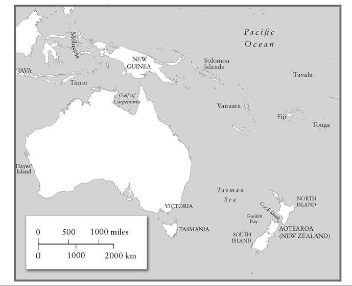
He set out westwards and passed to the south of New Guinea through the strait that still bears his name. Australia lay close by, and he saw ‘very large islands, and more to the south’, but he pressed on; he wended his way through the strait and headed through the Moluccas towards Manila. He was satisfied that he had now brought New Guinea under King Philip’s sovereignty, although if he thought the headhunting inhabitants would accept that he was deluding himself.15 From the far-flung islands of Polynesia he and his men had now entered the battleground, for that is what it was, where the Portuguese and the Dutch, not to mention the Spaniards and the English, fought for access to the finest spices of the East, islands far richer in the goods the Europeans sought than those Quiros and Torres had so far discovered.
The southern continent remained elusive. Mendana and Quiros had cast themselves in the mould of Christopher Columbus. This was not the best model to follow. What was different was the insistence that there were more continents out there, that the wealth of the East Indies was only a pale reflection of the wealth to be obtained from a temperate Antarctic continent. A southern continent was finally reached at the start of the seventeenth century. However, it took nearly 170 years for its edges to be properly mapped out; and the earliest contact was the result not of deliberate searching, in the wake of Villalobos, Mendana, Quiros and Torres, but of a series of accidents.
II
‘Captain Cook,’ Graham Seal has pointed out, ‘did not discover Australia, despite what generations of school children were once taught and many still believe.’ He adds that ‘modern Australia was not discovered at all. It was revealed.’16 Obviously the term ‘modern Australia’ needs to be emphasized, since the claim that it was a Terra Nullius, a land with no inhabitants, or at least no inhabitants who could claim rights over its possession, was used in the nineteenth century to justify its acquisition by Europeans, and the denial of rights to the native population - Aborigines were only allowed to vote in all the Australian states and territories from 1965 onwards.17
The Dutch were the first to reveal that they knew about the existence of what they came to call ‘New Holland’; but the Portuguese had almost certainly seen its shores before them. The debate about which Europeans first reached Australia has not aroused quite as much passion as the debate about which Europeans first reached the Americas, but it is mired in often credulous interpretations of roughly drawn maps. The sixteenth-century
Dieppe maps did show an extensive southern continent below South America. One historian of cartography has observed that the southern continent was ‘a special favourite of the Dieppe school’, and that ‘fantasy outweighs reality’ in many of the charts.18 These maps were often beautifully decorated with images of local flora and fauna, or even of native villages in South America and Africa. The warning that the coastlines traced on these maps become less reliable the further they are from anywhere Europeans had adequately explored has not always been heeded. A lively attempt to prove that the Portuguese were the first Europeans to reach Australia was published in 1977 and became standard teaching in Australian schools. The argument was straightforward: early maps, ultimately of Portuguese pedigree, show the coast of Australia. What may be one of the earliest Dieppe maps, the Dauphin Map, most probably dating from the 1540s, was clearly based on Portuguese sea charts. The claim that it shows part of Australia in some detail is based on the appearance of a large chunk of land described as lave la Grande, ‘Greater Java’, which is shown immediately to the south of plain lave, Java, separated from Java by a narrow channel, and lying close to spice islands such as Timor. Along its coastline appear such vaguely named places as Coste Dangereuse and Baye Basse. There are some agreeable images of scattered huts and of naked inhabit- ants.19 Other maps too showed a landmass south of Java or New Guinea. It was simply assumed that the great southern continent reached up towards tropical climates. And as for ‘Greater Java’, this had already featured in Marco Polo’s account of the East Indies, as part of the confused description of lands he had certainly not visited, whether or not he really lived for a time in China - he muddled up Java and Sumatra, and then he talked of Greater Java as the largest island in the world.
III
One way of resolving this issue is to state baldly that the Europeans knew Australia existed even before they had actually touched its shores. Arising out of their theories about a southern continent, and anchored in Marco Polo’s certainties, they were as convinced that a large landmass must exist somewhere south of the Spice Islands as Columbus had been that no landmass could exist between Europe and the Far East; and maybe it was a massive island rather than the world-encircling continent that mapmakers generally preferred to show. A sort of mental discovery actually preceded physical discovery, odd as it may sound. After all, much the same might be said about modern cosmology - dark matter and dark energy, it is claimed, must be there, partly to solve the mathematical equations, despite the fact that nothing has, if the pun can be excused, come to light. The universe has to be in perfect balance, just as the assumption in 1600 was that the earth could only be in balance if the southern continent weighed down the Antarctic pole. Discovery, as has been seen in other cases, such as the Norse arrival in America, was a gradual process that could result both in knowing things and in largely forgetting them; and the European discovery of the world beyond depended crucially on gaining some understanding of what has been found, and on making use of it. The problem with Australia, it will become clear, is that no one was terribly interested in what had been found, for no one had much use for what was there.
The finger is usually pointed at a certain Cristovao de Mendonga, who (it is argued) explored the waters south of Indonesia as early as the 1520s. He is known to have taken fourteen ships to south-east Asia, setting out from Lisbon in 1519; the theory that he was sent to block Magellan’s Spanish fleet from passing through Portuguese-dominated waters does not stand up, since, as has been seen, Magellan had not intended to return to Spain by way of the Indian Ocean. No one really knows why Mendonga was sent on his voyage or where his ships went.20 But it has long been argued that a shipwreck found in 1836 on a remote Australian beach on the coast of Victoria by two men who had gone out to catch seals was none other than one of Mendonga’s ships; supposedly made of mahogany, its timbers had disappeared by 1880. Mendonga has been found everywhere, but nowhere does the identification convince: a stone hut well to the south of Sydney, a set of iron keys found near a bay in Victoria, and so on. South-eastern Australia is surely the wrong place to look; later, Dutch ships would sometimes be shipwrecked off western Australia, as they tried to cut across the Indian Ocean to the East Indies, although a swivel gun found in the sands near Darwin, in the north of Australia, might well be from a Portuguese ship, date unknown.21 These reports, like the discussions of the Dieppe maps, offer plenty of opportunity for semi-informed fantasy. Perhaps the most bizarre of the claims is that a sixteenth-century Portuguese manuscript carried an illustration of a kangaroo. That said, it is highly likely that Portuguese ships were occasionally blown on to these shores, though if they were wrecked it is quite possible that their crews went down with their ships, or died on land, and news of these chance encounters failed to reach the Portuguese bases in Java and elsewhere.
Speculation about a great southern land turned into reality when the Dutch began to take a shorter route across the Indian Ocean, allowing the Roaring Forties, which had carried their ships out of the Atlantic and past the Cape of Good Hope, to blow the ships still further eastwards, so that somewhere below the underbelly of Java they could wiggle through the Sunda Strait and arrive in Batavia (Jakarta), the Dutch centre of operations. This became regular practice after i6ii, after Hendrik Brouwer sailed 4,000 miles across the ocean to reach Java directly from southern Africa.22 In many ways this was a safer route than one further to the north, since the Malacca Strait was a notorious haunt of pirates, besides which the Portuguese still controlled Melaka until 1641, when it fell to the Dutch (the red-coloured Stadthuys, or town hall, is the oldest Dutch building in the Far East).
Speculation about who reached Australia first from Europe comes to an end with the Dutch. The Duyfken, or ‘Little Dove’, is the first of the Dutch ships known to have arrived in Australian waters. Twenty metres long, this was what the Dutch called a jacht, or yacht, and she would have carried no more than twenty sailors. After a successful trip to the East Indies under the patronage of the VOC, during which she had engaged in battle with a Portuguese flotilla off the island of Bantam in December 1601, she already had a record of trading successfully in eastern spices. Her captain was Willem Jansz, or Janszoon, and he took her back to the Indies in 1603, from where she was sent south to see what might lie underneath Indonesia. Along the coast of New Guinea there were some ugly encounters with the inhabitants, and the same happened when the ship turned south and landed off the shore of Australia - a sailor was killed after being stuck through with an Aborigine spear. Legends that circulate among one of the native peoples, the Wik, tell of a large wooden ship and of their encounter with those on board, who needed help in digging a well, and who showed the Aborigines how to use metal tools. It seems the Dutch interfered with local women, and then the Wik decided they were unwelcome, so they watched until the Dutchmen had climbed down into the wells they were making, and then set upon them and killed them. Clearly this is a confabulation drawn from many tales and visits, but the story is widespread in several versions.23
It became increasingly obvious that the, or a, southern continent had been discovered, as more and more ships, travelling in the wake of Brouwer, ended up willy-nilly on the shores of western Australia or its offshore islands and kerries. The VOC ship the Eendracht, captained by an old Baltic and Mediterranean hand named Dirk Hartog, was one of the lucky ships whose landfall in October 1616 took place in relatively calm conditions. Hartog even inscribed a flattened pewter dinner plate with the date and the names of the senior crew and supercargo and left it on an island near the westernmost point of Australia. The plate was seen by another Dutch visitor in 1697; he replaced it with his own, which is now in a museum in Fremantle, Western Australia.24 Yet a claim to Dutch lordship was not thought worth pursuing. As reports came back of the desolate land (most of the ships visited the bleak, dry edges of Western Australia), it became obvious that this southern continent could supply neither gold nor spices. It was sear- ingly hot and inhabited by unfriendly people whose technology was the simplest one could imagine, in modern terms Palaeolithic peoples, ‘a dry cursed earth without foliage or grass’.25
The Dutch were not alone in being cast upon these shores. The English traders who were trying to insert themselves into the spice trade took the same risk, crossing the Indian Ocean and occasionally striking land too far south, in Australia rather than in the Indonesian islands. They knew of the new route across the Indian Ocean, tried it successfully and thought that they could repeat the crossing in a straightforward way; but in May 1622 the Tryall, or Trial, a newly built English East India ship, still out in what seemed to be open water off Australia, ran aground on sharp rocks concealed beneath the waves, and began to break up. About two thirds of those on board, who may have numbered 150 souls, had to be left to their dismal fate after the captain and other crew members used the ship’s two small boats to reach Java. Trial proved to be an appropriate name: its captain, John Brookes, was accused of negligence - of failing to post a watch, of concealing the evidence that the ship was off course, and of abandoning most of the crew to a certain death. It seems that he lied about the location of these rocks, which meant that they remained a hazard to shipping for a couple of centuries. Disputes about what had happened and about how far Brookes was liable generated vast reams of paper, and reached the highest court in the land, the House of Lords. However, the evidence is even richer than that: a wreck found off Western Australia in 1969 by not terribly scrupulous treasure-hunters is probably that of the Tryall, and exploration of the site, sometimes conducted with explosives rather than with a trowel, yielded anchors and cannon. If this is another ship, then it only proves that Brookes’s refusal to indicate exactly where the dangerous rocks lay had further tragic consequences long after his own death in poverty and obscurity. The leader of the team who found the wreckage, Alan Robinson, became known as the ‘gelignite buccaneer’. He was arrested for interfering with the site of the Tryall, found not guilty, and later arrested again for murder; by then he had had enough of life, and hanged himself in gaol.26
Knowledge of the continent gradually grew, as stretches of its northern coasts, around the Gulf of Carpentaria, were sketched; but none of the European visitors saw any profit in a desolate land inhabited by often hostile people who entirely lacked the luxurious sophistication of the native rulers encountered in Java. The most famous shipwreck, because of the high drama that followed, remains that of the Batavia, a VOC vessel that set out from Holland in October 1628, in a fleet of eight ships bound for Java. On board was the supercargo Francois Pelsaert, who was the brother-in-law of Brouwers, the man who had discovered the fast route to Java and was now a much-respected director of the VOC; and the ship carried 600 tons of cargo, including twelve chests full of silver with which to pay for the spices of the East Indies. Pelsaert was on his way to join the cabinet of the governor of Batavia, the irascible Jan Pieterszoon Coen, and there were whole families on board - about 300 people.27
The Batavia had become separated from the rest of the convoy, but the ship was confidently ploughing through the seas en route to Java in June 1629 when, during a night watch, the ship’s lookout saw what he thought was surf spray. Since he knew they were nowhere near land, the captain decided that this was just an effect of the moonlight and that they should carry straight on - which bore the Batavia on to a coral reef. Pelsaert felt the keel and rudder grind against the reef; ‘I fell out of my bunk,’ he reported.28 There was no hope for the ship; it could never be refloated or repaired, but it was not heading for the bottom of the sea quite yet, so there was time to prepare a proper evacuation of those who had not been washed overboard already, using the ship’s boats. And the good news was that, with the dawn, scattered coral islands came into view, so that the whole day was spent ferrying the crew and passengers towards a couple of these islands. It was a slow process, and by the evening seventy people were still stuck on board the disintegrating ship. A few saved themselves by swimming to the coral islands, but many drowned; and the islands did not, in any case, have much to offer: there was wildlife, including both wallabies and pythons, but no water.
Desperate for a supply of water, Pelsaert and Jacobsz, the captain of the Batavia, spied out what seemed to be mainland, and took a longboat across to what was the western shore of Australia. They saw a few Aborigines, but found virtually nothing to drink:
We there began to dig in various places, but the water was salt; a party went to the high land, there by luck they found some holes in a rock, where sweet water from the rain had been left... Here we quenched a little our great thirst, since we were almost at the end of our endurance, and since leaving the ship had had only one or two small measures a day.29
The problem was that the captain, the supercargo and their small group of men were moving further and further from the survivors camped near the wreck of the Batavia. They decided that they would head for Batavia, rather than the Batavia, in their longboat, report to Governor Coen and request help for the survivors. Coen, unimpressed by what had happened, flung the captain in gaol and sent Pelsaert back; the issue was not simply human lives, for the cargo of silver had been huge, and could not be left lying around for anyone in the world to pilfer. But Pelsaert and Jacobsz had deliberately put the recovery of people above the recovery of cargo; invoking God’s name, they had drawn up an agreement in which they stated their ‘utmost duty to help our poor companions in their distress’, by appealing to the governor.30
Pelsaert’s ship took a couple of months to find the survivors, arriving at the coral islands in September 1629. Pelsaert was not clear in his mind where the wreck lay, and the weather did not help. Remarkably, some of the crew and passengers were still alive. However, the conditions under which they lived were alarming, not just because of the inadequate supply of food and water. Pelsaert’s deputy, Jeronimus Cornelisz, had taken charge and had gathered together on the largest atoll those he thought most reliable. Others were sent to outlying coral reefs, where the chances of surviving were thought to be slim (though some of them found quite generous supplies of food and water before long). That left him with 140 men, women and children under his command. Cornelisz saw every mouth that had to be fed as a liability. He unleashed a psychopathic reign of terror. It has been suggested that his fury stemmed from the fact that he belonged to an extreme wing of a dissident Protestant sect, the Anabaptists, and that he believed that the murder of ungodly folk was licit.31 But this seems a weak explanation of his crazed behaviour. He would dress up in fancy robes, stolen from Pelsaert’s sea chest, as if he were king of his little realm, while his followers adopted a uniform of red cloth trimmed with gold lace, all of which had been recovered from the hold of the wrecked ship.
Cornelisz’s followers happily executed anyone who resisted his orders. A Dominee, or minister, of the Dutch Reformed Church was travelling out on the Batavia with his wife and seven children; most were massacred by Cornelisz’s men, though the Dominee and one daughter were allowed to live, so long as they did not show any grief at what they had witnessed. The daughter was forced to enter into a mock marriage with one of Cor- nelisz’s toughs, which at least guaranteed her survival; other women were made the common property of the gang, but the number of murders is thought to have reached 115. When Cornelisz discovered that about fifty of those he had sent to another island (now known as Hayes’ Island) were surviving quite well, he launched an invasion, though he was captured and his men were nearly all killed. This did not stop his followers from waging war on the defenders of the other island. So when Pelsaert arrived he found chaos, death and stories of horrifying barbarity.32
It was not difficult to establish the truth. Cornelisz himself was recovered from captivity on Hayes’ Island, where he was still wearing the grand robes that Pelsaert had brought along on the voyage. However, they were filthy by now: he had been kept in a hole in the ground, and was forced to pluck the feathers off birds captured for their food. As a result the beautiful robes were now covered in guano and bits of feather. He was sentenced to be executed, after his hands had been chopped off, and most of his troop of followers were hanged. Seventy-seven people deemed loyal to the VOC remained, to be taken to Batavia. There was another task to perform: Pelsaert set to work recovering the cargo of silver, and, remarkably, ten of the twelve chests were brought up from the sea. A couple of offenders, Pelgrom and Loos, who were guilty of appalling crimes, had somehow gained Pelsaert’s mercy, perhaps because he wanted to show that he was quite unlike the vengeful and violent Cornelisz, and they were put ashore on the mainland, along with items of truck - bells, beads, wooden toys, mirrors - to be used in trade with the native population. They were ordered to search for information about sources of gold and silver, and to watch for any VOC ships that were passing, so they could send smoke signals and be picked up. This confirms that there was already regular traffic along the shores of Australia; it was just that the Dutch did not believe there was any profit to be found in the new continent.33 His handling of the situation should have earned Pelsaert some credit, but instead he lost his place on the governor’s council, and went off to fight the Portuguese in Sumatra, dying soon afterwards. As for Pelgrom and Loos, they never managed to hitch a ride on a VOC ship, and must have died somewhere along the coast of Western Australia, the first Europeans to inhabit this strange land.
The Batavia had an afterlife: its wreck was found in 1963, and the islands were explored, leading to the recovery of guns, coins and other bits and pieces from Hayes’ Island, where a simple stone ruin is now celebrated as ‘Australia’s earliest European structure’. A number of skeletons have also been found, mostly in mass graves, and many of the bodies bear witness to the extreme violence of Cornelisz and his cronies: one victim was hit over the head with a sword by a right-handed attacker who stood directly in front of him. The sword left a two-inch mark on the victim’s skull. The victim was unable to defend himself by raising his arms, which showed no cut marks, suggesting that he was tied up and awaiting execution. The preferred method of execution was to smash open the skull of the victim.34 These remains of a ship and of murdered people stand as testimony not to an act of colonization, but to the passionate hope of those who resisted Cornelisz that before long they would be taken as far away from Australia as possible.
IV
The wrecking of the Batavia and other early experiences of Australia did nothing to encourage interest in a continent that would, nonetheless, soon become known as ‘New Holland’. There was, on the other hand, quite a strong interest in mapping the shores of Australia, and in identifying reefs and shoals that could threaten ships plying along Brouwer’s route; and that would mean more expeditions along its shores. Dutch ships even penetrated along the southern shores of Australia; in 1626 the ship beautifully named ’t Gulden Zeepaert, ‘The Golden Seahorse’, reached what is now the state of South Australia, and its course was duly noted on VOC charts. This meant that half of the southern shoreline of Australia had been mapped.35 Moreover, the assumption remained that a great southern continent would surely lie to its south, and would be a far more attractive place, with a temperate climate and plenty of riches worth exploiting. Australia, however, was seen as the very negation of the type of place that the Europeans hoped to exploit and colonize, a nightmare world inhabited by black folk who were caricatured as less than human, cannibalistic and (this at least was true) lacking any knowledge of the advanced technology that could be found in the East Indies, or even in the relatively undeveloped societies of the Polynesian islands.
Not surprisingly, then, the aim of two famous expeditions to Australia in the mid-seventeenth century was not the further exploration of the barren continent, but the continuing search for places where the Dutch could trade profitably, particularly a land supposedly rich in gold that had come to be known as ‘Beach’, a name whose origins went back to Marco Polo’s fantasies about the Indies.36 Abel Janszoon Tasman was a fortyyear-old Calvinist who set out from Batavia on a wide sweep of southern latitudes in 1642. He enjoyed his drink; later in his career he was deprived of his command after he hanged a troublesome sailor while he was drunk, not bothering to go through the due process of a trial.37 He came in sight of Tasmania, not realizing that it is a large island lying off the coast of Australia, and sailed around the bottom, demonstrating that this was not, alas, part of the great southern continent. He was keen to honour the governor-general of the Dutch Indies, so he named this land ‘Anthonio van Diemens Landt’ after him. He also claimed it for the Netherlands. There was no sight of the inhabitants, the Tasmanian Aborigines who were eventually wiped out by white Australians, but there was good evidence that the land was inhabited: sailors set on shore reported thick smoke rising out of the forest, and for some reason Tasman concluded that ‘there must be men, of unusual height’ - the usual tropes about giants, monsters and savages were being wheeled into place.38 Southern Australia, like western Australia, was, frankly, a disappointment.
Slightly more promising was an accidental discovery further east, the other side of what has come to be known as the Tasman Sea. At the end of December 1642 his little fleet reached the northern tip of the South Island of Aotearoa (New Zealand). As soon as the Dutch ships arrived, two Maori canoes drew near; the Maori warriors on board kept challenging the Dutch, calling out to them and blowing on shell trumpets; the Dutch responded in kind, shouting, blowing their own trumpets and attempting to scare the Maoris by firing a cannon. Overnight things remained quiet, but the next morning a Maori catamaran set out to investigate the Dutch ships. Before long eight Maori boats were circling the ships. The first catamaran carried thirteen naked men; they must have been a formidable sight, covered in tattoos and clearly very hostile. The Dutch did try to send a small boat to shore, but one of the Maori canoes headed straight for the Dutch boat, ramming it; the Maori crew tussled with the Dutch sailors, clubbing and killing four Dutchmen, and carrying off their bodies. The Dutch would have assumed that the bodies were taken to be eaten, which is not impossible. The bay where these events happened was given the name ‘Murderers’ Bay’ by an irate Tasman, though it is now known more politely as Golden Bay.39 This bloody reception had the effect the Maoris had hoped for: the strange visitors in their massive boats left and headed north, not bothering to explore Aotearoa in any depth.
Tasman had been made aware that the people he was dealing with now were very different in appearance and style of life from the native Australians; but he failed to work out the shape of the two great islands of Aotearoa, and imagined that Cook Strait, which divides North from South Island, was simply a large inlet; but he did realize, on sailing north all the way to Fiji and Tonga, that wide watery spaces separate Australia from New Zealand, and therefore Australia must have an east coast that would link up with the areas already discovered by the Dutch. In other words, Australia is a continent, not a protrusion out of the southern continent. Tasman had no idea of the shape of New Zealand, since he only saw a little of South Island and the west coast of North Island, and his bitter experiences there did not encourage him to stay longer.40 Even so, the
islands began to be marked on Dutch maps by the middle of the seventeenth century, patriotically named after the Dutch province of Zeeland. Tasman took the view that he had arrived on the shores of the southern continent, and that the coastline further south trended all the way to South America, but somehow his reports did not convince the VOC that the Company needed to probe deeper. The VOC was apparently more struck by the similarities between Australia and New Zealand than by the differences between the two lands and the two sets of inhabitants.
These mediocre results were not disappointing enough to stop the VOC from commissioning a second voyage, in the hope of understanding how all the different pieces of coast that had been identified linked up, if at all. At the end of another uninspiring trip the verdict was confirmed:
Thus they secured nothing advantageous, but only poor naked beachrunners, without riches, or any noteworthy fruits, very poor, and at many places bad natured men... Meanwhile this great Southland has been gone round by the aforesaid Tasman in two voyages and is reckoned to contain in it 8,000 miles of land as the charts drawn thereof, which we send to your Worships, make known. That such great land lying in various climes... shall have nothing of profit to find is scarcely acceptable.41
The attitude of the VOC was, then, entirely materialistic. Indeed, one of the tasks assigned to Tasman was the recovery of a treasure chest that had gone down with the Batavia - not that he managed to find the wreck or the castaways who had disappeared on land. The verdict of the VOC was typically ungenerous: thanks to Tasman and his predecessors the Dutch now had a fair idea of the dimensions and shape of Australia, the problem being that it was the wrong continent. There was still confusion, long after Torres’s voyage, about whether Australia and New Guinea were joined together. A map of around 1690 drawn on fine Japanese paper and preserved in Sydney, known (through its provenance) as the Bonaparte map, reveals that the Dutch voyages to Australia did result in the mapping of its western, northern and southern coasts, and there was clearly an assumption that the eastern coast was not too dissimilar.
Tasman’s voyages were important in the mapping of the south Pacific and the northern edges of the Southern Ocean, but they were based on false premises about the southern continent, and the discovery of both Tasmania and Aotearoa was in many respects accidental: Tasman simply came upon these places. There is a striking contrast with the voyages of Captain Cook well over a hundred years later. Cook’s voyages were seen as scientific endeavours: Joseph Banks and other scientists were on board; observation of the transit of Venus across the Sun was one aim, but accurate mapping of the Pacific was another. Cook carefully identified areas along the coast of Australia that had been neglected ever since the Dutch had arrived in that continent. He established that Aotearoa was not a spur sticking out of a vast Antarctic continent, but two large islands inhabited by a substantial Maori population. Although one motive was to search out land for British colonization, Cook was also commanded to look for the southern continent, even if many of the dreams of finding the golden realm of Beach had long ago evaporated.42
The story of the first European encounters with Australia and New Zealand differs markedly from the history of European encounters elsewhere in the world. Greed remained a powerful motive for exploration, and yet this was greed that neither country could satisfy - Aotearoa because of the hostility of its Maori inhabitants, and Australia because the land was too poor, dry and unproductive to attract interest. But in sailing as far as Aotearoa, Tasman had reached the last significant inhabited coastline as yet unvisited by Europeans. There were still icy lands empty of people to discover further to the south, and coastlines to map, but Europeans had now truly encompassed the entire world, even if the Maoris had no reason to feel grateful for their presence.
More on the topic 41 Austrialia or Australia?:
- Australia
- Article 5.7 S&P loses Australia appeal over misleading investors
- What are Other Jurisdictions Doing? Sentencing Data and Councils around Australia
- Article 8.5 Australia to use market prices for Libor
- REFLECTIONS ON MULTICULTURALISM: CONVERGENCE AND DIVERGENCE IN AUSTRALIA AND SINGAPORE
- Germany, Britain and Australia in New Guinea
- Case Study: Darug Clan, Australia
- Colonial legacies: family laws in Singapore and Australia
- PRACTICAL CONSEQUENCES OF LEGAL DUALISM AND MONISM IN THE APPLICATION OF SHARI’AH FAMILY LAW TODAY IN AUSTRALIA AND SINGAPORE
- CHAPTER 8 Mixed Messages: Gender, Peace, and the Mainstream Media in Australia, 1983-1984
- Chapter Five “I Just Think it All Comes Down To How The Girl Behaves as to How She is Treated”: Sexual Harassment “Survival” Behaviours and workplace Thinking in Rural Australia
- The Mount Rennie Rape Case of 1886: Politics, Mercy and Justice in Late Nineteenth Century Australia
- You may have a favorite national park, such as Everglades in Florida, Grand Canyon in Arizona, Bialowieski in Poland, or the Great Barrier Reef in Australia.
- Karren M. Plain, Ian Marsh2 and Auriol C. Purdie Sydney School of Veterinary Science, University of Sydney Sydney Australia; Elizabeth Macarthur Agricultural Institute, NSW Department of Primary Industries, Menangle, Australi
- THE COMMONWEALTH
- In the early 1980s, the Australian women's peace movement staged two major protests: in 1983,