Empire as a Geopolitical Variable: A Historical Outline
The first “imperial” era in pharaonic history was the Old Kingdom (2686-2125 bce), a period in which there was no true empire, since we lack evidence that Egypt occupied or administered foreign territories.[41] What appears instead is a foreign policy consisting of infrequent military and trade encounters with Egypt's neighbors in Africa and the Levant, along with—to judge by the limited archaeological evidence—occasional diplomatic contacts with Syrian states like Ebla.[42]
When considering the evidence provided by the execration texts (i.e., ritual formulae written on small crude figurines of prisoners which enumerate potentially hostile countries and people), Nubia appears to have been a major concern for the pharaohs.
The majority of the peoples and places evoked are broadly located in Northeast Africa and they offer an invaluable, detailed picture of the political situation south of Egypt.[43] Egypt's preoccupation with Nubia is further confirmed by occasional references to substantial pharaonic armies deployed there, sometimes numbering up to 20,000 men, which often resulted in the capture of prisoners and cattle, which were brought back to Egypt as booty.[44] Nevertheless, commemorative texts present a rather unbalanced picture of relations between Egyptians and Nubians—tacitly assuming that conflict with “barbarian” Nubians was inevitable—to the point that it has been often admitted that these expeditions aimed at eliminating a potential menace on the southern border by depopulating Lower Nubia.[45] However, recent archaeological discoveries prove that this was not the case, and that a Nubian presence, in fact, also extended deep into the Western Desert and even into Egypt itself, especially in the region between Gebelein and Elephantine. Hunters, for instance, figure prominently among the inhabitants of several villages at Gebelein, as do nomads, whereas Nubian cultic centers have been discovered around Hierakonpolis. Other inscriptions reveal that their collaboration was essential to the success of Egyptian caravans entering inner Africa.[46] Whether Buhen was only a fortress or a factory, its location as an isolated Egyptian outpost in Nubia would have been inconceivable unless its presence was at least tolerated by the Nubians. The same could be said of Balat, in the oasis of Dakhla. It seems preferable then to assume that the Egyptian policy consisted, in fact, of a combination of alliances, partnership, collaboration, and armed conflict with the different Nubian polities mentioned by the texts. As for the apparent scarcity of Nubians in Lower Nubia, it cannot be ruled out that this was the result of their mobility as well as their increased specialization in pastoral production, herding, and transhumance across vast areas, which might have been undertaken in order to meet a possible Egyptian demand for hides and other products.In this light, Elephantine appears to have been a crucial base for the organization of caravans, as well as a multicultural society consisting of interpreters, soldiers, traders, leaders of expeditions, agents of the king, and Nubians—including sjnw (an Egyptian term translated as “runners” or “quick messengers”)—who are frequently attested in the execration texts (brief texts with lists of potential enemies of Egypt written on figurines that represented prisoners).[47] Trade appears to have been an important activity there from the very beginning of the Old Kingdom, and not always necessarily subordinated to the state. For instance, the main authorities of Elephantine did not hold the title of “great chief of the province,” as did their Upper Egyptian counterparts, but rather that of “overseer of interpreters/foreigners.” and their autobiographical inscriptions abound in fascinating details about the expeditions sent deep into Nubia. Herkhuf and Sabni, for example, led caravans of hundreds of donkeys loaded with incense, ebony, several kinds of resin, panther and lion skins, elephant tusks, and other goods.[48] The routes in use followed the course of the Nile and desert tracks (like the “route of the oasis”), the particulars of which probably depended on a combination of logistical considerations, the location of the goods sought, and the potential for hostile encounters.
Nubians thus appear less as a threat or as passive partners, and more as politically arranged mediators, pursuing their own interests and facilitating the success of Egyptian expeditions.Another element of such activities in Elephantine is the geographical scope of the expeditions led by the local leaders, which reached across a far wider area than in neighboring Nubia. Herkhuf, for instance, followed both the oases and the Elephantine trails. It departed from this locality, but also from Thinis, which was several hundred kilometers to the north.[49] Khnumhotep states that “I went forth with my lords, the noblemen and seal-bearers of the god, Tjeti and Khui, to Byblos and to Punt [lacuna] times. I returned safely after having crossed these lands,”[50] and Heqaib was sent to the Land of the “Asiatics” (Aamu) in order to bring back to Egypt the corpse of an official killed there, together with his troops, when he was building a ship to travel to Punt.[51] Similar networks are attested in an exceptional late third millennium inscription from the same place, where an official collected the goods in Elephantine that had been brought from the Nubian lands of Medja and Yam, consisting in myrrh from Byblos, gold and copper from “The Land of the God” (= Punt and other sites), incense from Yam, ebony from Wetenet, ivory from a region whose name is destroyed in the text, and several kinds of monkeys from other locations. Afterward, these goods were shipped to Heracleopolis, in the north.[52] The fact that Levantine goods arrived into Nubia and were collected by Elephantine officials reveals the existence of a trade network over a vast area (Levant, Punt, Nubia, the Eastern Sahara) that was not controlled by the Egyptian state. In fact, Elephantine officials also appear involved in such trade as a private venture, at their own initiative.[53] To sum up, Elephantine officials appear to have been true specialists in the provision of foreign valuables, not only from neighboring Nubia.
One of the main sources of metals and precious items (especially incense, myrrh, and semiprecious stone) was Punt.[54] Its remote location on both shores of the southern Red Sea, and the complex logistics needed to get there (including shipyards at Coptos, land trails crossing the Eastern Desert, and harbors like Wadi Gawassis), apparently precluded the possibility of armed conflicts and instead privileged trade expeditions.[55] Nevertheless, the one-sided picture in the Egyptian records needs qualifying. On one hand, it is quite possible that Punt was not necessarily the producer of all the goods sought by the Egyptians but was instead a crossroads for traders, where commodities from distant locations were exchanged and stored. In fact, the Indian Ocean appears increasingly to have been, from very early on, an important route where seeds, animals, and other goods circulated between Africa and South Asia[56] Perhaps the role of Punt was comparable to Dilmun (Bahrein), where Mesopotamian traders met their colleagues from distant countries, including India, Iran, and Oman. This could explain why goods from Punt reached Nubia independent of any Egyptian expedition, or why Asian seeds have appeared in several Nubian tombs, but not in Egypt. On the other hand, trade encounters between Puntites and Egyptians relied on mutual, not solely Egyptian, interests. And if Egyptians certainly sent trade expeditions to Punt, Puntites could eventually have made common cause with Nubian polities and attacked Egypt, coming to participate in internal Egyptian political affairs. In this respect it is worth remembering that governor Neheri I asserts at Hatnub, in Middle Egypt, that he faced a coalition of people from Nubia (the lands of Medja and Wawat), Asiatics, and Egyptians from both Northern and Southern Egypt. Moreover, another official—also from Middle Egypt, Khnumhotep I—boasted of helping his king to expel a local rival who was supported by Nubians and Asiatics.[57] Nubians and Puntites appear therefore in a more balanced light, as both active partners and eventual rivals of Egypt, while contacts with Northeast Africa and the Red Sea appear to be more complex than previously thought, involving not only state-sponsored ventures but also independent, private initiatives.
As for the Eastern Sahara under the Old Kingdom, two different strategies are illustrated, respectively, in the cases of Libya and the oasis of Dakhla. Campaigns against “Libyans” involved the capture of substantial numbers of prisoners and livestock: 1,100 captives and at least 13,100 livestock in one case, and hundreds of thousands of cattle, donkeys, and small cattle in another.[58] Whereas such figures should be treated with caution, they reveal nevertheless that “Libyans” raised flocks that were too large to be exclusively confined to the arid environment of the Libyan coast. It seems more likely to assume that their pastoral activities encompassed a vast area from Cyrenaica and the western oases to, at least, the western edge of the Delta—a vague border area dotted with substantial lakes, swampy areas, and meadows—which was well suited to grazing but underpopulated and difficult to control. There, we see evidence for Egyptian livestock centers that had officials concerned with cattle and pasture management.[59] As pastoralism is a specialized economic activity, often closely related to sedentary populations, its importance in the western Delta is quite probably linked to Egyptian demand, making it inevitable that conflicts over grazing rights and deliveries of cattle and other products might have erupted between herders and agents of the crown. This would explain the occasional armed encounters described by the sources.[60] A different strategy is attested further south. While the oases have only provided occasional evidence for a durable Egyptian presence there, Balat, at the oasis of Dakhla, emerges as a remarkable exception—a truly Egyptian town and administrative center, headed by a governor and tasked with providing necessary logistics for the expeditions crossing the desert toward Nubia and Uweinat in search for incense and other valuables.
Finally, while the Levant apparently avoided imperial conquest, judging by the evidence, it was only by providing access to precious valuables.
Byblos was the main trade partner in the Levant. Furthermore, like Elephantine, a trade and logistical base was apparently founded in the Eastern Delta and on its fortified border: Levantine temples have recently been discovered there,[61] while Iny, an official who carried out many commercial expeditions to the Levant, set sail from Ra-hat—“the first mouth (of the Nile)”—toward Byblos, Lebanon, and other countries in the area. In the course of his many voyages under kings Pepi I, Merenre, and Pepi II, the small fleets he commanded brought lapis lazuli, tin/lead, silver, and resins to Egypt, as well as “Asiatic” (aamu) men and women.[62] Nevertheless, armed conflicts were not unknown that involved repeated military expeditions and amphibian operations, as well as huge armies in the order of tens of thousands of men. As a result, Asiatic fortified camps were razed, houses burned, and trees and vines destroyed.[63] Unfortunately the precise situation of the region is unknown but it certainly corresponds to southern Palestine. Trade and war appear thus as alternative strategies in the Levant, but permanent occupation was precluded, as in Nubia. Egypt seems instead to have pursued control of the strategic land route leading into Asia (the “Ways of Horus”), the fortification of the Eastern Delta border, and the creation of checkpoints at the end of caravan routes. Nesutnefer was an overseer of fortresses and watchtowers in the provinces of Abydos and Hemmamiya, in Middle Egypt, as well as in the Eastern Delta. He thus controlled the routes from Asia and the Western Desert that reached the Nile Valley. The recent discovery of a chain of small circular forts in western Sinai, dating to the end of the Old Kingdom, reveals that military protection was needed at that time for the mining expeditions sent to this area. This was perhaps related to the conflicts described in the inscriptions of Weni and Heqaib of Elephantine.[64]Consequently, the absence of a true Egyptian empire in the third millennium may be explained by the fact that no other power challenged Egyptian interests and access to these routes (and their attendant goods). Both Nubia and the Levant were divided into many polities whose population and resources could not match those of Egypt. And, further afield, we hear of no other competing power contesting the Syro-Levantine and the Anatolian regions, with the short-lived exception of the Akkadian empire (ca. 2334-2218 bce). As a result, no foreign invasion or premeditated attack threatened Egypt after the collapse of central authority following the Old Kingdom. This is worth stressing, as governors and cults continued to operate, apparently undisturbed, in the isolated outpost of Balat, at the oasis of Dakhla. Meanwhile Nubia, then more politically organized and with rulers who occasionally advertised Egyptian royal titles, never invaded Egypt. What is more, Nubian soldiers fought in the contending armies of Thebes and Heracleopolis, and managed to acquire property in Egypt itself during the civil wars of the late third millennium. Trade continued to link Nubia, Punt, Byblos, and the Aegean across Egypt.[65]
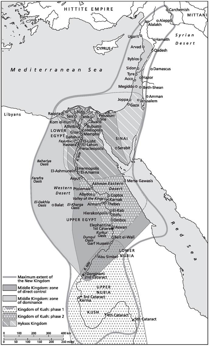
However, the reunification of Egypt at the very end of the third millennium witnessed the revival of the same geopolitical concerns as in previous periods— that is, control of riverine, maritime, and desert routes connecting the Red Sea, the Eastern Sahara, and northern Sudan to the Mediterranean. Military campaigns were launched against the western oases and Lower Nubia in order to bring them under Egyptian control. Meanwhile, maritime expeditions to Punt resumed and armies were sent to Palestine and Lebanon. See map 1.1.
Two major changes, however, are apparent. First, significant maritime bases were established at Mersa/Wadi Gawassis, on the Red Sea coast, and at Tell el-Dab'a, in the Eastern Delta. Here Asiatics were settled as trade specialists, mercenaries, and interpreters, while Byblos remained the privileged Egyptian partner in the Levant.[66] The growing importance of Asiatic affairs is also illustrated in literature (the execration texts from this period evoke dozens of Asiatic place names, peoples, and local leaders, while the Tale of Sinuhe is set in the Levant) and social dynamics (Asiatic serfs/slaves were transferred between dignitaries), while new administrative titles describe ships and trade with Byblos. As for Mersa/Wadi Gawassis, recent discoveries of Cananean, Cretan, Yemeni, and Eritrean wares, as well as inscriptions mentioning Punt, reveal the geographical scope of goods passing through this
Map 1.1. Pharaonic Egypt.
Source: Bang and Scheidel, 2013, The Oxford Handbook of the State in the Ancient Near East and Mediterranean, 66. Copyright: Oxford University Press.
harbor connecting Egypt and Punt. In fact, the emergence of a Northwest Semitic alphabetic script (“Proto-Sinaitic”) in the first centuries of the second millennium provides further evidence for intense contacts between Asiatics and Egyptians. Inscriptions in this script have been found at Serabit el-Khadim (Sinai), a mountain containing important turquoise mines and a temple dedicated to the goddess Hathor. They were probably incised by Asiatic workers or by passersby. They have also been recovered at Wadi el-Hol (a desert route near Thebes leading to the Egyptian oases), close to the inscriptions left by Bebi—an “overseer of the troop of Asiatics”—and by a certain Mesy, whose mother was Nebet-Kepenet (literally, the “Lady of Byblos”).[67]
Second, a chain of impressive fortresses was built around the area of the Second Cataract, in Nubia.[68] The first group (Ikkur and Baki) controlled access to Wadi Allaqi, the main route to the gold and copper mines of the eastern Nubian Desert, as well as an important caravan trail. The second group, about 150 kilometers further to the south, were built around the ancient fortress and factory of Buhen, a gold- producing area with easy access to the trails of the western Nubian Desert and the oases. Finally, the third group was built about 100 kilometers further to the south, in a zone that enabled easy control of the Nile. Both papyrological and epigraphic evidence reveal that control of trade was one of the main aims of this network of fortresses and, in fact, settlements flourished around some of them, as at Uronarti[69] and at Mirgissa, where Egyptian houses surrounded by warehouses constituted the Open City.[70] It is worth noting that the construction of the third group of fortresses does not imply the abandonment of previous groups, which suggests that their main purpose was not to form a fortified border against Nubian powers. A useful parallel is the relationship between Romans and pastoral populations in North Africa, wherein forts served to direct, control, and tax the production of pastoralists at fixed points that also served as markets, recruitment, and “information collecting” centers.[71]
Trade thus appears to have been a major goal of Egyptian foreign policy, to the point that the infrastructures built for this purpose remained in use after the collapse of the pharaonic authority that created and supported them. Tell el-Dab'a became the capital of the new Hyksos kingdom, which was heavily involved in trade with Nubia and the Levant.[72] Meanwhile, the Nubian fortresses were not only not abandoned or dismantled, they became the nucleus of settlements whose inhabitants recognized the Nubian ruler as their lord.[73] In fact, the contrast in Middle Kingdom policy toward Nubia and the Levant is sharp. In the first case, a network of fortresses and patrols sought permanent, comprehensive, military control, which made it possible to control the desert and riverine routes that connected inner Africa to the Mediterranean (along with the gold producing areas of Nubia and the Eastern Desert). Such control was facilitated by infrastructure on the Red Sea coast (e.g., the harbors of Mersa/Wadi Gawassis and Ayn Sukhna). Keeping in mind that Puntites attacked Elkab in alliance with Nubian tribes,[74] and that intermediary areas between Punt and Nubia—like the Gash Delta—played an important commercial role,[75] the strategic and geopolitical interests at stake in Nubia become clearer. As for their Levantine policy, data is scarcer. Certainly military expeditions against Palestine and Lebanon reveal a strategic concern, though this was apparently not followed by any permanent occupation or imposition of a durable “imperial” administrative structure.[76]
The end of the Middle Kingdom witnessed the consolidation of the Hyksos kingdom in the Eastern Delta and the rising power of the Nubian kingdom of Kerma. The Hyksos ruled a state that was in intensive contact with the Levant and was quite probably the hegemonic power over, at the very least, Lower Egypt. That region had broken up into a number of smaller polities whose rulers are primarily known from inscribed scarabs.[77] This situation resembles the Levantine political fragmentation, with its numerous petty states in mid-second millennium bce. Asiatic herders crossed into Lower Egypt through Wadi Tumilat.[78] Hyksos seals have also been found at Edfu, while some inscribed blocks with the names of Hyksos kings have been recovered at Gebelein. Contacts between Nubians and the Hyksos are also well attested through the oases of the Western Desert, and Nubian soldiers were present at the palace of the Hyksos king Khayan. Furthermore, a cuneiform tablet and a seal reveal some sort of diplomatic contact with Babylonia, whose commercial interests in the Levant are well attested at Hazor, in northern Palestine. Also noteworthy is the evidence of trade and contacts between Egypt, Syria, and Anatolia.[79] In fact, dense trade networks flourished during this period and linked the Eastern Mediterranean to Mesopotamia and Northeast Africa. Such trade was not necessarily channeled through the states and their institutions (e.g., palaces, temples) but rather by networks of private traders organized in “trade diasporas.”[80]
The response to this flourishing trade was the emergence of several powers that competed for control over Syria and Palestine, where the main trade routes converged. The capture of these lucrative circuits, which allowed states to levy tribute and eliminate rivals or at least restrict their access to this area, was the primary strategic concern for the states that dominated the Near East during the Late Bronze Age (1550-1200 bce).[81] The Hittite attack on Babylonia (1595 bce) can be better understood in light of the trade networks that linked Babylonia to Syria and Hazor and the rivalries it provoked between Babylonia and the dominant powers in Upper Mesopotamian (Mari, Assyria under Shamsi-Adad, and later Mitanni). The Egyptians incorporated themselves into this system already holding an important asset—Nubia and the Hyksos kingdom—the conquest of which meant the elimination of a primary competitor on the Nilotic axis. It also meant control over the routes connecting the Red Sea and Northeast Africa with the Mediterranean, as well as control over gold production areas. In addition to these strategic, productive regions, after the expulsion of the Hyksos and conquest of the Levant, Egypt also controlled the arrival routes of these goods going from the Red Sea and Arabia to Syria and the Levant, including many of the main harbors and key land crossroads, like the Damascus basin. The virtual monopoly over trade routes connecting productive regions and markets for exotic goods brought Egypt fabulous wealth—a time “when gold was more abundant than sand,” according to the diplomatic correspondence known as the Amarna Letters.
Within this context, Egyptian policy was built on the same principles prevailing in the Old and Middle Kingdom, the only difference being that, for the first time, it involved a direct confrontation with foreign states powerful enough to dispute its control over strategic areas. The Egyptian response was to build an empire. Nubia appears to have been the most strategic target. It was fully conquered and Egyptian influence reached the area around the Fifth Cataract, hundreds of kilometers further upstream than previous Middle Kingdom conquests. Not only the Nubian Desert and its rich gold deposits, but also the desert routes crossing this vast area (which probably represented an alternative land route toward Punt across the Gash Delta), thus fell under pharaonic control. As for the Western Desert, the recent discovery of a huge cistern excavated in the rock at Tundaba—between the Nile Valley and the oasis of Kharga—as well as ostraca mentioning taxes on liquids, show the extent of Egyptian authority over the surrounding deserts, their resources and trails. Towns and temples were founded in Nubia, Nubian princes were educated in Egypt, and a true administration was implemented in the region, supported by the collaboration and administrative integration of Nubian elites and rulers.[82]
Such control contrasts with the rather more informal organization of the Egyptian conquests in the Levant. With the exception of the first campaigns of the Eighteenth Dynasty, which reached the Euphrates, Egypt's main concern was limited to the coastal areas of Palestine, Lebanon, and Syria, as well as some zones that appeared as important trade crossroads during the Middle Bronze Age, like the areas around Hazor and Damascus. Even in the aftermath of the Egypto- Hittite treaty (ca. 1258 bce), when their respective areas of influence were clearly settled and mutually agreed upon, Egypt managed to preserve control over many of these strategic areas. This was in spite of the loss of the area around Qatna and Qadesh, along with the route leading to Babylonia. Sites like Sumur, Kumidi, and Gaza acted as administrative and organizational centers for Egyptian authorities. However, many petty kingdoms under Egyptian sovereignty apparently preserved a high degree of autonomy, as long as they collaborated with Egyptian authorities and remained loyal to the pharaoh.[83]
The absence of the kinds of imperial structures created in Nubia casts some light on the policy toward both regions. What appears, from one perspective, to be comprehensive Egyptian dominion over Nubia probably conceals a high degree of collaboration with local elites, who were essential to preserving any stable control over such a vast area and its lucrative resources. In fact, the temples and towns founded there at this time can be interpreted as evidence that significant resources were left in Nubia and reinvested in the region. Even donations of land to temples and royal cults in Nubia, involving the participation of local potentates, appear to be a strategy to strengthen links between the Nubian elite and the pharaoh.[84] None of this was implemented in the Syro-Levantine region. The Amarna diplomatic archive reveals, by contrast, a surprising lack of concern toward their regional elite. However, appearances may be deceptive and, in fact, Nubia and the Levant may simply show two variants of the same policy, which allowed local powers a substantial degree of autonomy in order to gain their collaboration. In any case, both Mitanni and Hatti, the main rivals of Egypt in Syria, could hardly afford to extend their territories to distant, productive areas in Egyptian hands (most noteworthy, those producing Nubian gold, African ivory, exotic imports, and incense from Punt). This gave Egypt a substantial advantage in international exchange. Military confrontation thus concerned only the control over some of main land routes in the north, in Syria, and never seriously threatened Egyptian control over the southern routes that passed through Palestine and southern Syria. This is probably why Egypt did not seek to thoroughly integrate the Levant as it did with Nubia. Quite significantly, when new land routes appeared that evaded Egyptian control (for instance, the Arabian Incense Road) and the Nubian elite stopped collaborating with Egypt, Egypt's empire collapsed.
Nevertheless, toward the end of the New Kingdom, Egypt entered a period of strenuous military conflict on several fronts that contributed to the gradual breakdown of the empire. Military expeditions were launched against the Transjordan states of Edom and Moab. The Sea Peoples ravaged the Levantine coast and could only be stopped at the Delta. Libyans moved into Egypt through the Western oases and settled in the Delta as well as in certain regions of Fayoum and Middle Egypt. Meanwhile, a revolt led by the viceroy of Nubia was followed by a brief occupation of Thebes before his final retreat into Nubia, which then was definitively lost to Egypt. Interpretation of these dramatic events still remains controversial, especially because of the sudden divergence from previous centuries when relative geopolitical stability prevailed. Changes in production, in the development of new, alternative trade routes, and the emergence of small traders, outside the sphere of palatial intervention, have been proposed as the main explanations for the movements of peoples and the crisis of many palatial systems in the Eastern Mediterranean. Whatever the case may be, the disruption of maritime exchange networks appears as a surprisingly devastating vector in state collapse, and reveals the economic importance of trade for Late Bronze Age societies.[85]
In the case of the Levant, the Ramessides sent several expeditions against Edom, in what has traditionally been interpreted as an effort to bring under Egyptian control the copper-producing area of Timna. One such expedition, under Ramesses III, is reminiscent of that of Weni at the end of the third millennium, in that it involved a combination of land and maritime forces. However, the recent discovery of an inscription of Ramesses III at the oasis of Tayma, in Saudi Arabia, reveals quite unexpectedly that Egyptian interests in Transjordan went beyond resource exploitation, pursuing control over land routes further east that included this strategic caravan crossroads. Keeping in mind that copper mining at Faynan and Timna—along the Arabah Valley—began in the Late Bronze Age and Early Iron Age as a small-scale activity, without any trace of external control,[86] we can infer the fact that mobile populations were important vectors in establishing alternative trade routes. These, in turn, eroded the control of Bronze Age states, like Arameans in Upper Mesopotamia, Chaldeans in Southern Mesopotamia, and Moabites and Edomites in the southern Levant. In this respect it is noteworthy that the involvement of Ramesses III in Tayma coincides temporally with the last known maritime Egyptian expedition to Punt, just before the Incense Road connected South Arabia directly by land with the Transjordan kingdoms and the Mediterranean.
Similar links between mobile populations and trade are observable on the western border of Egypt, and the Libyan invasions must be understood in the context of conditions prevailing in the Egyptian Delta. As stated before, the fact that cattle represented a substantial part of Libyan herds must mean that abundant water and pasturage were available to them and, consequently, that they traveled around the Western Delta. Nevertheless, the foundation of huge vineyards and olive plantations in the oases and around the western branch of the Nile, together with the needs of the new capital, Pi-Ramesses, located in the Eastern Delta, as well as the numerous herds kept in Lower Egypt, doubtless had a deep impact on the resources and land use of this region, making conflicts inevitable. As for the fortress of Zawiyet Umm el-Rakham, strategically located on the Mediterranean coast halfway between the oasis of Siwa and the Nile valley, the archaeological evidence reveals that trade was an important activity in the area. It also reveals that Libyans were in charge of the horticulture and agriculture of the settlement.[87] As Libyans were also involved in trade, providing skins, elephant tusks, aromatic plants, and other precious items through the desert tracks, it becomes clearer why they, allied with some Peoples of the Sea, attacked the traditional grazing areas within Egypt (e.g., the Delta, Fayoum, and Middle Egypt) and settled there. All the oases of the Western Desert and the border areas of the Western Delta controlled by Libyans were crossed by exchange networks that connected the Mediterranean to the Fayoum through localities like Kom el-Hisn.[88] As for Nubia, its withdrawal from the Egyptian Empire was concomitant with deep changes in the southern Red Sea region at the turn of the first millennium, which saw the emergence of the Incense Road as well as the first known states in South Arabia and the Ethiopian plateau, with intense contacts between these regions of the southern Red Sea.
More on the topic Empire as a Geopolitical Variable: A Historical Outline:
- ARCHAEOLOGY AND THE STUDY OF RELIGION: A HISTORICAL OUTLINE
- .. the Roman Empire... is now regarded in spite of all the barbarism, all the superstition, and all the misery, as one of the most interesting of all historical phenomena.
- The concept of “empire” has long proven notoriously difficult to pin down, partly due to a steady accumulation of ideological baggage over time, but also because of the improbable range of historical phenomena
- Observations on the Problem of “Historical” and “ Non-historical ” Nations
- Yekelchuk S.. Stalin's Empire of Memory: Russian-Ukrainian Relations in the Soviet Historical Imagination. Toronto: University of Toronto Press,2014. — 252 p., 2014
- Narrative Outline
- Geopolitical Pivot
- The Geopolitical Crossword
- Outline of This Book
- Geopolitical Context