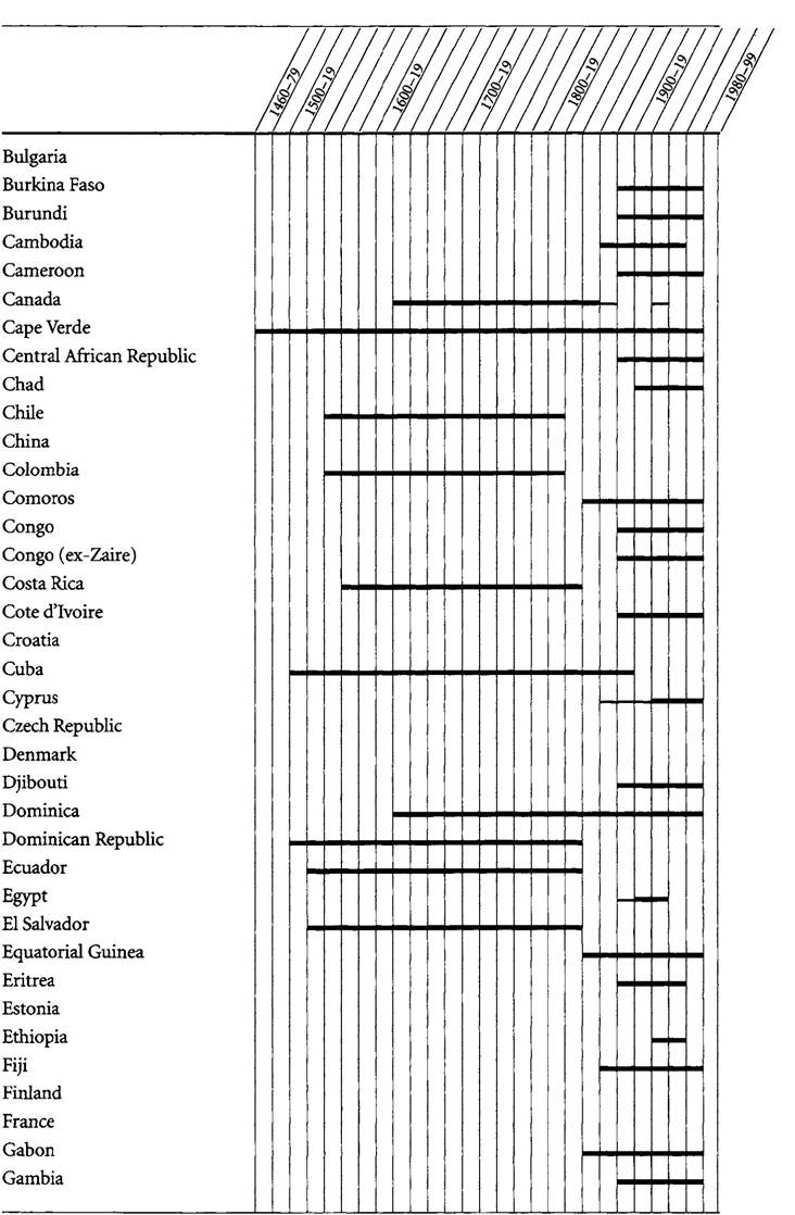
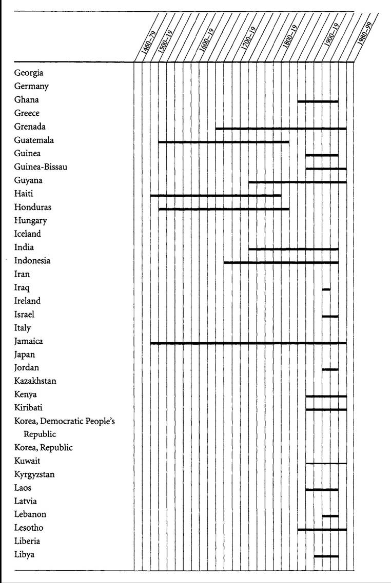
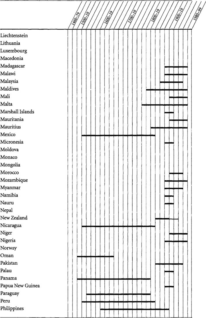
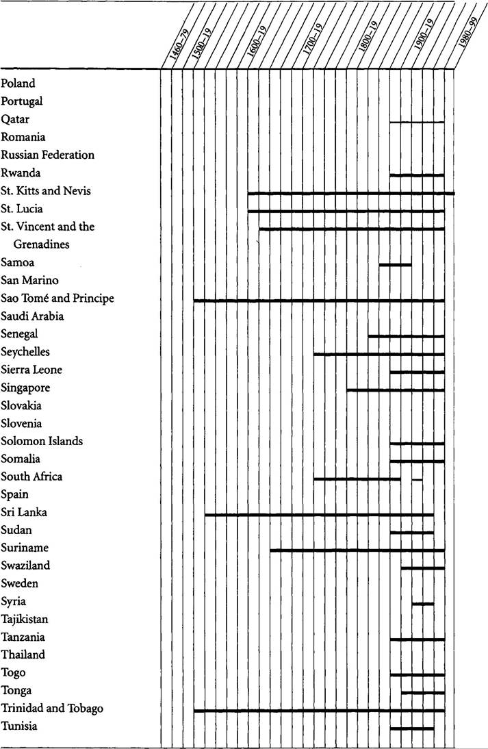
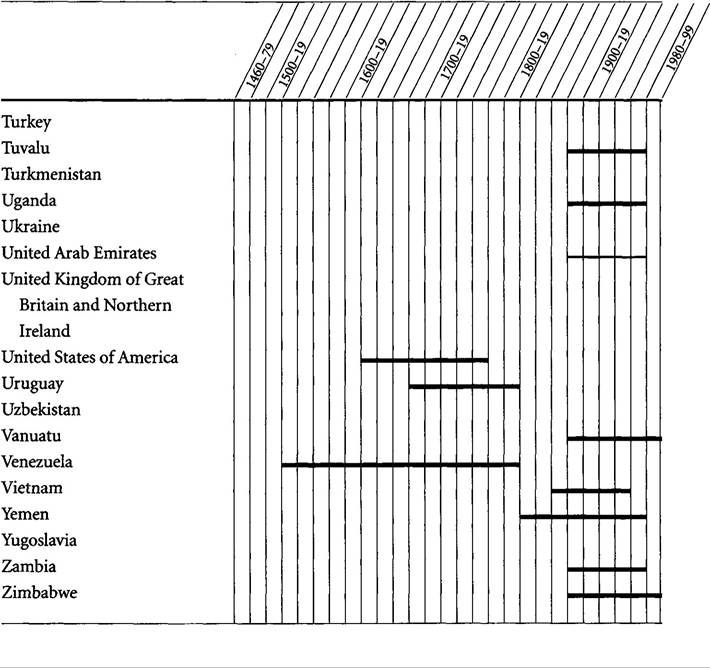
APPENDIX SPATIAL AND TEMPORAL DIMENSIONS OF THE OVERSEAS EMPIRES
Listed here are the 188 states belonging to the United Nations on January i, 2000. Of these, 125 are countries outside of Europe that were once colonies of one or more European metropoles.
Bold and light lines mark the duration of imperial rule in these countries. Also listed is Tuvalu, an island chain that gained independence from Great Britain in 1978 but did not join the United Nations until 2000.Each vertical bar represents two decades, beginning with 1460-79. A country has a line for a twenty-year period if a portion of its currently defined territory—beyond small coastal enclaves—was governed by a metropole during part or all of that period. The test of governance is whether officials appointed by metropolitan authorities (a government or a government- approved charter company) collected taxes or imposed some degree of order through recognizable bureaucratic structures and were formally authorized to control a territory’s foreign relations as well as to regulate aspects of its domestic affairs. For more on the definitions of colony and metropole, see chapter 2.
Deciding when colonial rule begins is problematic, especially in the Old World during phase 1. Contestable judgment calls are unavoidable whatever one’s criteria. One reason I use twenty-year segments rather than assigning specific starting dates is to avoid conveying an inappropriately concise impression of the takeover process. Even this arrangement risks making a process that was often gradual and subtle appear more precipitate—and more obvious to the parties involved—than it actually was.
For small islands I take the year of European arrival if this is marked by territorial claims and/or the start of continuous settler presence. Where the initial European presence on a larger island or continental mainland involved control of a coastal port, I focus on the period when Europeans exercised governmental powers outside the original enclave rather than on the date a port city was founded or taken over.
Thus I date colonial rule in India from the 1750s, when the English East India Company began collecting taxes in Bengal, not from the early 1500s, when Portugal carved out trading enclaves on the Malabar coast The colonial era in the East Indies is dated from the 1680s (Dutch control over the Javanese sultanates of Mataram and Bantam), not from the founding in 1619 of the company’s administrative center, Batavia, or from early sixteenth-century Portuguese spice-trading activities.These criteria generally understate the duration of European informal influence overseas, since even a tiny enclave could have substantial influence on its hinterland. Examples were the slave-trading “factories” along West Africa’s coast from the sixteenth through nineteenth centuries. On the other hand, the criteria overestimate the duration of formal colonial rule in many territories because inhabitants of hinterland areas may have evaded European control for many decades after people in more accessible regions had become colonial subjects.
A country’s final bold segment marks the transition from colonial status to independence. Independence could be dated from the year a territory’s leaders declared it, the metropole acknowledged it, or the first sovereign state officially recognized it. In the vast majority of phase 5 cases these three criteria produce identical results. Where results diverge I pick the self-selected date, if only because this is what a country’s citizens celebrate. The independence date for the United States is listed as 1776, and that for Haiti as 1804, even though Britain and France did not formally acknowledge the change in status until 1783 and 1825, respectively.
A United Nations member state that was part of a larger unit when that unit became independent is assigned the latter’s independence date. Thus, Central American countries which in the colonial era were components of New Spain are deemed independent when Mexico broke from Spain, not several years later when they broke from Mexico.
Bangladesh is assigned the date for Pakistan, Singapore the date for Malaysia.Tanzania consists of two territories—Tanganyika and Zanzibar—that united after gaining independence separately.
A country has a light line for the period when it was a quasi colony. This category covers a wide range of relationships with one metropole, Great Britain. I classify Canada, Australia, New Zealand, and South Africa as shifting from colonial to quasi-colonial status when domestic control of internal affairs in these settler-led territories was formally recognized by Dominion status: 1867 for Canada, 1901 for Australia, 1907 for New Zealand, 1910 for South Africa. These states’ de facto independence is set at 1931, when the Statute of Westminster relinquished London’s control over foreign affairs. Cyprus and Egypt are considered quasi colonies during the decades when they were technically under Ottoman suzereignty while their foreign relations were determined by agents of the British Crown. Their ambiguous status ended with formal annexation by Britain at the start of World War I.
Three states—Kuwait, Qatar, and the United Arab Emirates—were not formally incorporated into overseas empires and are not counted among the United Nations’ 125 ex-colonies. But they are classified as quasi colonies because their rulers negotiated treaties retaining control over domestic affairs while ceding jurisdiction over foreign affairs to Great Britain. This status lasted while these treaties were in force. Afghanistan, Bhutan, and Oman might be listed as quasi colonies, on these same grounds, for short periods in late phase 3 and phase 4. But I do not do so because Britain’s control over their foreign relations appears to have been more tenuous than with the Arab sheikhdoms.
Countries attaining independence from a non-European state following a period of European rule have a bold line only for the years when governed by a European metropole. These countries are Cuba (Spain to 1898; United States), Philippines to 1898 (United States), Eritrea (Italy to World War II, British trusteeship to 1952; Ethiopia), and German possessions turned over to League of Nations mandatory powers following World War I: Papua New Guinea (including former German New Guinea; Australia), Namibia (South Africa), and several Pacific island chains: Marshall Islands (Japan; U.S.
after World War II), Micronesia (Japan; U.S. after World War II), Nauru (Australia, with United Kingdom and New Zealand), Palau (Japan; U.S. after World War II), and Samoa (New Zealand). Ethiopia excepted, all nonEuropean powers that were terminal colonial rulers were themselves once European colonies.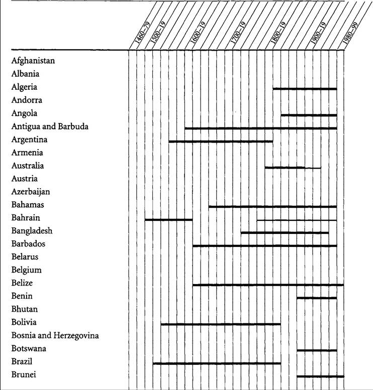
4M
More on the topic APPENDIX SPATIAL AND TEMPORAL DIMENSIONS OF THE OVERSEAS EMPIRES:
- SPATIAL AND TEMPORAL ASPECTS OF DECOLONIZATION
- Demographic and Spatial Dimensions
- WHY STUDY EUROPE’S OVERSEAS EMPIRES?
- CONCEPT 17.1 Agents of change act on communities across all temporal and spatial scales.
- 2 Why Did the Overseas Empires Rise, Persist, and Fall?
- Abernethy David B.. The Dynamics of Global Dominance: European Overseas Empires, 1415-1980. Yale University Press,2002. — 524 p., 2002
- The fourth phase in the history of overseas empires encompassed two world wars and global economic depression.
- Interdependence Between the Temporal Power and Sacred Domains
- The medieval abrogation and the modern temporal conflict of laws
- Overseas Populations
- Changing Dimensions
- Dimensions on which psychological measures of humility vary
- ECONOMIC DIMENSIONS OF EXPANSION
- TEMPORAL AND GEOGRAPHIC SPREAD OF MITHRAISM
- Patterns of species diversity at different spatial scales are interconnected
- Competition in seasonal environments: temporal overlap
- Dimensions of Religions
- Extending our current understanding of spatial competition
- (Re)Configuring Spatial Context