36 The Fourth Ocean
I
So far this book has looked at three great oceans. Yet most atlases would show that there exist five oceans. One of them, the Southern or Antarctic Ocean, is really a southward extension of the Atlantic, Pacific and Indian Oceans, and might or might not embrace the bottom of Australia and New Zealand, its northern limits being as arbitrary as those laid down by the Spanish and Portuguese treaty that divided the world in 1494.
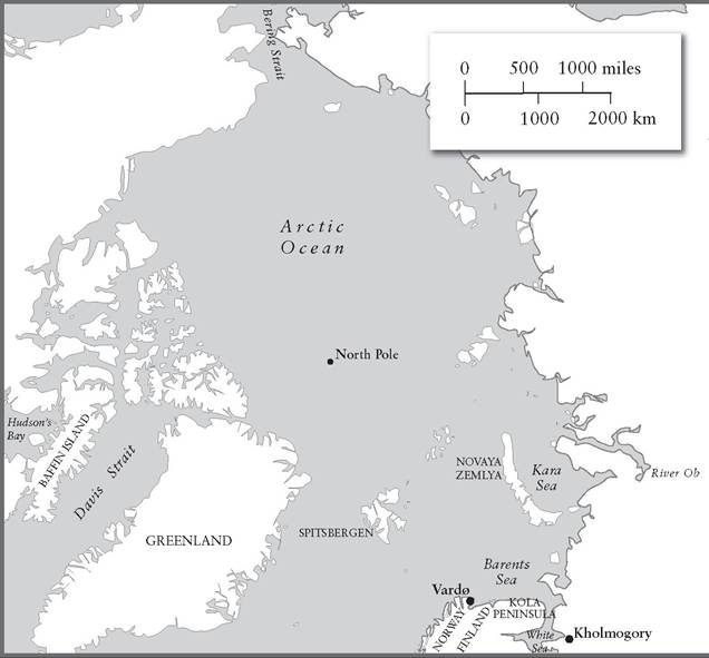
The other, the Arctic Ocean, has barely featured so far, because even the Norse voyages to Greenland were confined to Atlantic waters. An occasional trip northwards up the Davis Strait, or (at the other end of the Norse maritime world) voyages as far as Spitsbergen, brought Norse ships above the Arctic Circle, although the Davis Strait, separating Greenland from Baffin Island, is clearly an extension of the Atlantic. Even before the discovery of North America, the question of what lay far to the north gave rise to fanciful speculation, based on snippets of knowledge about the Sami (or Lapps). Martin Behaim’s globe, created around the time of Columbus’s first voyage, imagined that the North Pole consisted of a circular island surrounded by ocean, and betrayed the usual confusion about what Greenland was, making it an extension of Eurasia beyond Norway.1 Before 1555 the Swedish cleric and geographer Olaus Magnus reached the north of Norway and wrote about the midnight sun as well as the fur trade and Sami customs.2The lure of the Arctic to sixteenth-century sailors consisted not of lands within the Arctic Circle but of seas that would take them across the Arctic into warmer waters studded with spice islands. Only at the start of the twenty-first century has the melting of polar ice made the passageways around the top of North America and around the top of Russia look viable. Magellan had shown that a route round the bottom of the Americas did exist; but it was almost beyond human endurance, and the opportunity to find a passageway to the north of either the Americas or Russia that
would bring European merchants to Cathay and the Indies could not be passed by - not, at any rate, by the English and later on the Dutch, who hoped to avoid territories over which Spain and Portugal exercised or claimed to exercise dominion.
Now and again, it is true, the English could take advantage of close relations with Spain and claim access to Spanish markets as far afield as Hispaniola. But the relationship between England and Spain was bumpy. Henry VIII’s alliance collapsed in acrimony over his divorce from Catherine of Aragon, and Philip II’s brief period as king of England, through his marriage to Catherine’s daughter, Mary, was followed by a Protestant succession.This was not simply a matter of commercial and political alliances. English merchants trading in Andalusia had established a base at Sanlucar de Barrameda, an outport of Seville, under the patronage of the dukes of Medina Sidonia, who were something of a law unto themselves and had all sorts of creative ideas about promoting prosperity (including the settlement of Gibraltar with converted Jews in 1474). Now the English claimed that they had become the target of the Spanish Inquisition, which had extended its persecutions beyond crypto-Jews and crypto-Muslims to embrace those who rejected papal supremacy: ‘many of our nacion be secretly accused and know not therof so that all the hole company daylly dotth live in great feare and daunger.’3 Yet the English craved access to the products of the Indies, all the more so as the economy began to expand. One possibility was to create warm ties with the rulers of Morocco, which, it was hoped, would satisfy English hunger for sugar, while an alliance with its rulers would box in the king of Spain close to home and would maintain pressure on the Portuguese, who still controlled several Moroccan ports. So, from the 1550s onwards, a ‘Barbary trade’ developed, and from the 1580s it was managed by a Barbary Company licensed by Queen Elizabeth and based in London.4
Sugar was one thing; but there was a whole pharmacopoeia of drugs and a larder of spices that the English wanted to acquire. Here the twin notions of a North-West and a North-East Passage around either the top of North America or the top of Russia came into play.
It is no surprise that the initiative lay with Bristol merchants who had already been heavily involved with first John and then Sebastian Cabot, particularly the Thorne family, wealthy merchants and benefactors (the school founded by Robert Thorne the Elder still survives, as Bristol Grammar School). In 1530 his son, also Robert, wrote at length to King Henry VIII, arguing that the king should seize the opportunity to increase his power and influence by sending expeditions to ‘divers New lands and kingdoms, in the which without doubt your Grace shall winne perpetuall glory, and your subjectes infinite profite’. The younger Thorne was now based in London, but had lived for a while in Seville with, it is said, his Spanish mistress; and the advantage he placed second - ‘infinite profite’ - was the one that mattered more to him. Thorne underplayed the dangers from ice and cold, and emphasized instead the fact that one could keep sailing during the perpetual daylight of an Arctic summer, ‘which thing is a great commoditie for the navigants, to see at all times round about them’. He seems to have assumed that the best route would take ships close to the North Pole itself, right over the top of the world. All this led Robert Thorne to an extravagant account of how English ships could then choose to return by way of the Magellan Strait or the Cape of Good Hope, having in the meantime visited ‘the richest lands and Islands of the world of golde, precious stones, balmes, spices, and other thinges that we here esteem most’.5These plans were not followed through, and by 1569, when Gerard Mercator published a new version of his very influential world map, the view began to spread that a direct polar route was probably impossible, because the North Pole was supposedly surrounded by four closely packed islands; however, that still left the passages to the north-west and the north-east open, assuming they were not blocked by ice. ‘No other map in the Atlas proved to be so erroneous,’ it has been remarked, all the more so as Mercator credulously included information from a bogus account of the travels of a late medieval Venetian named Zeno, who was supposed to have been washed up on the shores of the mythical Frisland and Estoti- land, said to be well-populated mid-Atlantic islands.
However, this map did assume the existence of what is now known as the Bering Strait, opening up the route to China around the top of Eurasia.6Thorne’s friend Sebastian Cabot was an even more enthusiastic supporter of the idea of an Arctic route, patiently awaiting the day when it would become obvious that this was an opportunity not to be missed. He was still arguing the case half a century after his father had discovered Newfoundland but had failed to open up the promised route to Cathay. Sebastian had explored waters off Canada (and had possibly entered Hudson Bay) while in English service in 1509, and he had returned to the English court by 1548, after spending thirty-four years working for the king of Spain.7 This time, though, the target of his expeditions was left vague: he took charge of a newly formed ‘Companie of the Marchants Adventurers for the Discoverie of Regions, Dominions, Islands and Places Unknowen’. In Richard Hakluyt’s remarkable collection of sixteenthcentury travel narratives the planned voyage is aptly described as ‘a newe and strange Navigation’. Funds were raised by inviting subscriptions of £25, which brought in £6,000, enough to buy and fit out three ships. Given the choice between a north-eastern and a north-western route, the consortium decided in 1553 that the best prospects lay in the direction of Russia; after all, several expeditions already sent towards the American north-west had found no passageway. Sir Hugh Willoughby and Richard Chancellor were to lead the expedition, armed with letters from the young King Edward VI addressed, in time-honoured fashion, to sundry ‘Kings, Princes and other Potentates’; the ships attracted enormous attention when they sailed downriver and passed the royal palace at Greenwich: ‘the Courtiers came running out, and the common people flockt together, standing very thicke upon the shoare: the Privie Counsel, they lookt out at the windows of the Court, and the rest ranne up to the toppes of the towers.’8
The optimism that had led to the creation of the consortium was certainly misplaced.
Off the coast of northern Finland, storms dispersed the ships and Willoughby’s ship along with one other pressed on into the Barents Sea, which lies between Spitsbergen and the long and desolate pair of islands simply known as Novaya Zemlya, ‘New Land’, before icy conditions forced the ships back to the Kola Peninsula at the very top of Scandinavia. Forced to spend the winter there, all sixty-three sailors and merchants were in no condition to survive the freezing conditions. A couple of years later the Venetian ambassador in London told how the crews had been found by Russian fishermen, literally frozen to death and still sitting at dinner, or writing a letter, or opening a locker.9 No doubt these details were embellishments; but the challenge of the north-east route became much clearer, and the Venetian ambassador must have combined satisfaction with horror, aware that his native city already faced quite enough competition in the spice trade from the Portuguese. Better news came from the third vessel. Chancellor’s ship ended up on the coasts of the White Sea, from where Chancellor set out on an ambitious but successful overland journey to Moscow, laying the foundations for a successful fur trade between England and Russia which came to be handled by a licensed Muscovy Company. Quite apart from the fascination English reports show at the customs and beliefs of the Russians, and quite apart from the friendly relations that developed between Ivan the Terrible in Moscow and Elizabeth I in London (even extending to a marriage proposal from the psychopathic tsar), the Muscovy trade opened up other possibilities: the road was now open to Persia, but overland, and a trickle of exotic eastern goods reached England by this long and roundabout route. Unexpected success in Muscovy deflected attention from the NorthEast Passage, and the sense that the north-eastern route was not viable was strengthened when a second expedition, in 1555, was guided some of the way by Russian sailors and reached Novaya Zemlya. However, the ship, a small pinnace, had to turn back because of the frightful conditions at 7OoN - not just the ice floes but the unwelcome attention of a massive Right Whale that ‘made a terrific noyse in the water’ and swam within a few feet of the ship.10The Muscovy Company continued to raise money for expeditions; these reverses did nothing to dampen enthusiasm for voyages across the Arctic, and the Muscovy Company was fortunate in its choice of commander: Anthony Jenkinson, who set out in 1557, proved to be an indomitable explorer of central Asia, reaching Persia and Bukhara, and acting as Queen Elizabeth’s representative at the court of the highly temperamental tsar. What Ivan really sought was a military rather than a trading alliance, in the hope of extending his power in the Baltic and keeping the Swedes at bay. Although the privileges to the English also included trading rights along those parts of the Baltic that lay under Russian control, it is hard to see what real benefit a military alliance would have brought England, apart from the opportunity to sell armaments. In 1572 Jenkinson managed to negotiate the restoration of English trading rights when Ivan the
Terrible, in one of his all-too-frequent spasms of rage, had abolished them, and he worked his charm on the tsar so successfully that he was sent back to England bearing ‘our hearty commendations to our loving sister, Queene Elizabeth’.11 The English merchants established a base at Kholmogory, about fifty miles upriver from the White Sea: ‘in this town the English men have lands of their own, given them by the Emperour, and fair houses, with offices for their commodity, very many.’12
Not deterred, the Muscovy Company tried yet again in 1580, even though the ships the company sent were apparently tiny - a crew of ten on one barque of forty tons and a mere six on the other, perhaps in recognition that passage through the ice would be even more difficult with large vessels of the sort that had been used by Willoughby and Chancellor. The real interest of this voyage lies in its manifest: confident of reaching China, the cargo included a ‘large Mappe of London to make shew of your Citie’; plenty of English clothes, including hats, gloves and pan- tophles, or slippers, not to mention glassware from both England and Venice and a great assortment of ironmongery, which makes one think that among the investors were manufacturers of locks, hinges and bolts. In return the explorers were expected to obtain not just plenty of seeds, in the hope that Chinese herbs could be cultivated in Europe, but a map of China. They were also supposed to spy on the Chinese, carefully noting fortifications and naval activity in the places they visited. Needless to say, they did not reach China, although they did penetrate a little way beyond Novaya Zemlya before the ice of the Kara Sea forced them back. Yet Russian sailors already knew how to navigate further along the northern coast of Eurasia right up to the great River Ob.13
The English were frozen out of the Arctic; but others were not discouraged. At the end of the sixteenth century Dutch navigators also saw a route across the top of the world as a way to keep their trade in exotic goods alive while immersed in conflict with Spain. They had the support of Prince Maurits, the Stadhouder, who occupied a sort of presidential role in the United Provinces of the Netherlands and who in 1593 ensured that money was invested in this route. Here was an opportunity to strike sharp blows against Catholic Spain that appealed to Calvinist ministers of religion such as Petrus Plancius, a forceful hardliner who took an especial interest in geography and navigation, lecturing and publishing on the subject, including maps that outlined a route through the Arctic Ocean.14 Mapmakers, though, could only go so far, which was not very far at all. What was needed was an expedition. Doing it the hard way, the great Dutch navigator Willem Barentsz sailed into Arctic waters and mapped out parts of the sea that now bears his name, as well as the islands of
Novaya Zemlya on its eastern edge; but even he confused Spitsbergen with Greenland, and in 1596-7 he and his crew had to endure a harsh winter immured in a wooden house built from driftwood and parts of their ship. The ship itself was completely trapped in ice, so they were forced to travel in open boats all the way from Novaya Zemlya to the Kola Peninsula. Barentsz died en route; how anyone survived is the real surprise, although Russian sailors occasionally came to their aid. A bestselling account of this dramatic voyage was in the bookshops as early as 1598. Normally one expects these narratives to be embellished, but, when in 1871 a Norwegian skipper chanced upon the remains of a wooden hut in this remote corner of the Arctic, it became obvious that the basic facts at least were true: the hut was still stocked with all the paraphernalia of the voyage, from spoons and knives to an iron chest with an elaborate lock, to pewter candlesticks, to a ‘pitcher of Etruscan shape, beautifully engraved’, to small weapons, to Dutch books and engravings (so many of these that they were clearly taken to be put on sale in China), and much else.15 Nor did Dutch expeditions end at this point; the lesson of the attempts to find a North-East Passage was that failure only increased the appetite. The realization that Arctic waters teemed with whales, including the enormous Arctic Right Whale, attracted the Dutch ‘North Company’ into the seas to the north of Russia. A Right Whale could be as much as sixty or seventy feet long, and at least 2,000 pounds of baleen plates could be extracted from the carcass, as well as a mountain of blubber.16
II
If, as Mercator’s atlas and other maps showed, North America was physically separate from Asia, then the North-West Passage was also worth considering. Maybe the world was constructed in such a way that the route did not actually pass through the Arctic: after all, when the French king sent Giovanni da Verrazano on the journey that took him past what became New England, in 1524, Francis I hoped he would find a way through to the Pacific somewhere in those latitudes, and the same idea motivated his support for Jacques Cartier’s exploration of the St Lawrence River in Canada.17 A woodcut of around 1530, made in Nuremberg, seems to reflect Sebastian Cabot’s assumption that a long, reasonably wide and accessible Fretum Arcticum, or Arctic Passage, passed between Greenland and northern China - on the woodcut Greenland was shown as a peninsula sticking out of Asia, so that Asia was made to reach right across the top of a stunted and much-reduced North America. Some maps and globes of this period followed this model and attributed the discovery of a NorthWest Passage to the Corte Real brothers from the Azores, who had rediscovered Greenland and Labrador around 1500. The assumption that the route existed became more and more widespread, especially since the idea had the imprimatur of Sebastian Cabot: ‘one Sebastian Cabota hath bin the chiefest setter forth of this journey or voyage.’
The Muscovy Company kept its options open, concentrating at first on the north-eastern route but holding a monopoly on the exploration of the north-western one as well. Humphrey Gilbert, Walter Raleigh’s halfbrother, argued the case for a new route to Cathay, or China, with determination in a tract of 1566 entitled A Discourse of Discoverie for a New Passage to Cataia : ‘you might justly have charged mee with an unsettled head if I had at any time taken in hand, to discover Utopia, or any country fained by imagination: But Cataia is none such, it is a country, well knowen.’18 Gilbert presented his arguments to Queen Elizabeth, whose court he attended, and accompanied his tract with a map showing how the two American continents, joined to one another, were still separated by water channels from a large southern continent and from an Asian landmass that did not, this time, include Greenland. He had a vision of large spaces of open water giving access to a channel into the Pacific. No less significantly, he urged the court to think of the advantages exploration of this route would bring England, as its relations with Catholic Spain steadily deteriorated following the death of Queen Mary and Philip’s loss of recognition as king of England.19
Queen Elizabeth did not act on Gilbert’s optimistic advice for several years. Then, in 1576, Martin Frobisher set out to explore the North-West Passage, and Gilbert’s advice was printed and distributed as a sort of prospectus for Frobisher’s voyage. Frobisher had some experience of the west African trade, but he was, in essence, one of those adventurous and unscrupulous privateers who often received tacit support from the queen.20 This made him all the more suitable as a challenger to Spanish and Portuguese mastery over the spice trade. A ‘Company of Cathay’ came into being, but it only raised £875, enough to equip two thirty-ton barques and a small pinnace, total crew thirty-four men, ‘alarmingly small vessels’ engaged on a ‘madcap venture’, in the words of the leading historian of this route.21 The tiny fleet set out in summer 1576; the pinnace sank with all hands in a storm west of Greenland, and one of the barques, the Michael, headed back home.22
Frobisher steered his own ship, the Gabriel, towards the southern shores of Baffin Island, where the crew encountered their first Inuit out at sea paddling their kayaks. Having assumed that the northern shores of this stretch of water were part of Asia, and the southern shores part of North America, Frobisher knew this to be absolutely correct when he saw the Inuit at close quarters; his colleague the Master of the Gabriel reported: ‘they bee like to Tartars, with long blacke haire, broad faces, and flatte noses, and tawnie in colour.’23 This was a similar mistake to that made by observers of Columbus’s generation, who had also identified the native peoples of the Caribbean and Central America with Asia.24 At first, relations with the Inuit were quite good; the Inuit offered the crew salmon and other fresh fish. Five sailors who were taking an Inuit back to the shore to collect his kayak, after he offered to lead the Gabriel back to the open sea, disappeared from sight, though memory of them remained remarkably strong among the Inuit, for whom, after all, this was their first encounter with English explorers:
Oral history told me that five white men were captured by Innuit people at the time of the appearance of the ships a great many years ago; that these men wintered on shore (whether one, two, three, or more winters, could not say); that they lived among the Innuit, that they afterward built an oomien [large boat], and put a mast into her, and had sails; that early in the season, before much water appeared, they endeavoured to depart; that, in the effort, some froze their hands; but that finally they succeeded in getting into open water, and away they went, which was the last seen or heard of them.25
The Inuit even remembered that there were three separate visits by Frobisher’s ships. However, an English narrative of the voyage paints a less positive picture: some English clothes were found in an Inuit camp overrun by Frobisher’s sailors on his second expedition, of 1577, and they can only have been left behind, or taken from, the five sailors who disappeared. Frobisher was inclined to think that the omnivorous Inuit had eaten the men rather than looking after them, for by this time relations with the Inuit had deteriorated badly and there were frequent clashes between the Europeans and the native population; besides, the image of the cannibalistic native American was widely diffused during the sixteenth century.26
Missing the entrance to Hudson Bay, Frobisher sailed some way down a fjord on Baffin Island, which became known as Frobisher Bay, and decided that this must be the passageway he sought. But in the event he turned back before winter could set in, reaching London with not much to show for his voyage apart from a fairly small piece of black rock, which, on close examination, seemed to contain fragments of a bright metal that the London assayers optimistically thought was gold, estimated to be worth £240 per ton of rock. This raised hopes to such a pitch that Queen Elizabeth was willing to invest £1,000 in a second expedition by the same two ships, while the Flemish geographer Abraham Ortelius is said to have made a jealous trip to London to see if he could steal some of the secrets of the north-western route, which would certainly have interested the Spanish masters of Flanders. Aware that the ships were venturing into lands that would never keep them supplied with the food they needed, the second expedition carried five tons of salt beef, sixteen tons of ship’s biscuit, two tons of butter (enough for half a pound per man per day) and over eighty tons of beer, which would provide eight pints (four and a half litres) per man per day - even so, the ships managed to sail in a straight line when so required.27 However, there was a subtle change in emphasis, as the Cathay Company now charged Frobisher with collecting many more samples of rock; collecting it in Arctic conditions out of what even in August was frozen ground was no light task, and the ships had to set sail before the end of the month because the Arctic summer ended early and the ice began to close in.28 Still, the queen was gratified, and, showing off her skill in Latin, she even gave the territories Frobisher had visited a new name, Meta Incognita, ‘The Unknown Limits’ - meaning that this was an unclaimed land to which neither Spain nor any other power had a prior claim.29
In a third, massive expedition, of 1578, consisting of eleven ships and 400 men, Frobisher collected still more of the rock, and happened upon the entrance to Hudson Bay. The aim was to create a permanent settlement, dedicated to the extraction of gold-bearing rock.30 He realized that this was very possibly ‘the passage which we seeke to find the rich country of Cathaya’, but everyone’s attention had turned to the pieces of black rock. Investment in Frobisher’s project boomed, as a mineral-processing plant with furnaces and mills was built at Dartford at great expense to render down the rock and extract the gold. The plant was supplied with 1,250 tons of rock when those of Frobisher’s ships that had survived the Arctic ice returned - only Frobisher’s flagship, the Michael, had been provided with a strengthened hull, and other vessels risked being crushed to pieces by the weight of the ice floes.31 Once processed, the rock mainly delivered iron pyrites, ‘fool’s gold’. Although iron pyrites tend to occur in places where real gold can be found, it remains astonishing that, in an age when alchemy was the rage, and learned figures such as John Dee gravitated around the royal court, such an elementary mistake was made. So, all too quickly, the bubble burst and the investments evaporated into thin air. Frobisher emerges with more credit than the assayers: he had not set out to find gold in North America, and he seems to have been a demanding but inspiring leader of his men; when digging up rocks became the business of the day, he somehow managed to convince them to put all their limited energy into hard physical labour; and by his third expedition he had recruited hundreds of volunteers.
Like the search for a North-East Passage, the search for the North-West Passage continued despite setbacks. After all, the saga of the false gold could be dismissed as a distraction from the real purpose all along, which had been to reach China. In the 1580s John Davis followed in the wake of Frobisher but then headed off into the strait now named after him between Greenland and Baffin Island.32 The early seventeenth century saw the heroic endeavours of Henry Hudson (who had already explored the North-East Passage) to work out the nature of the great sea that carries his own name and the all-too-modest qualifier ‘bay’. His efforts ended in disaster in 1611 when the crew mutinied, placed him, his son and a handful of crew members in a small boat, and cut them adrift in James Bay, the southernmost part of Hudson Bay. It is unlikely that the captain and his friends survived; they were given neither food nor warm clothing.33
A footnote to these expeditions is provided by the circumnavigation of the world led by Sir Francis Drake in 1577 to 1580 aboard the Pelican (later renamed the Golden Hind).34 He decided to follow the Pacific coast of not just South but North America a long way northwards, beyond the trajectory of the Manila galleons operated by Spain upon which he planned to prey. He also captured and rifled a number of Spanish ships whose route took them up and down the coasts of South America and Mexico, for the Spaniards were building towns along the shoreline, and the ‘wine of Chili’ was a fond target of Drake’s men.35 One explanation that has been offered for his insistence on sailing northwards into cooler climes is that he too was looking for a channel linking the Pacific to the Atlantic.36 Apart from anything else, the discovery of this legendary passage would offer a quick way back to England - his aim was not actually to circumnavigate the globe, but to harass the Spaniards in their own waters, first in the Caribbean and then in the Pacific; once in the Pacific, there was a good chance of capturing Spanish treasure ships where they least expected to face any challenges. Finally, when Drake realized that he could not return by way of the stormy Magellan Strait, he aimed for the Cape of Good Hope instead.37
More than ten years later, having been defeated by the Arctic, John Davis led an expedition into the Pacific by way of the Magellan Strait in 1591-2, hoping to resolve the problem of the North-West Passage ‘on the backe syde’ by following Drake’s route up the American coast until he found the way through. Disagreements with the joint leader of the expedition, combined with foul weather, forced Davis back to England before he had reached far beyond the southern tip of the Americas.38 Had he reached Alaska from Tierra del Fuego his expedition would surely be ranked as one of the greatest sixteenth-century voyages. As it was, Davis may have been the first to land in the Falkland Islands, where his crew were forced to live off penguin meat, on their way home. Inevitably, those mapping the shores of unknown seas kept an eye out for the express routes across continents that had first been postulated as a way to cross Africa and now were being postulated as a way to cross North America.
III
England and the Netherlands were not alone in eyeing these Arctic routes with interest. The Danes were well aware of the long history of Norse involvement in far northern waters, and at the start of the sixteenth century they were already operating a customs station on the northern tip of Scandinavia, at the place they called Vardo and the English called Wardhouse, ‘a haven or castel of some name in the kingdome of Norway’; it had been chosen as the meeting point for the ships of Hugh Willoughby and Richard Chancellor on their i ll-fated expedition into the Arctic Ocean.39 Shipping bound for the White Sea stopped there and dues were paid to the Danish king, who was ruler of Norway as well; meanwhile the Danish kings laid down plans to gain control over Greenland: King Frederick II hoped to persuade Martin Frobisher to lead an expedition there, and King Christian IV hired Scottish and English captains to assert Danish rule over the vast icy island. Once he thought he had achieved his aims in the north-west Atlantic, he turned his attention to the North-East Passage. He sent an enterprising and experienced seaman, Jens Munk, as far as the ice would permit. Once this route proved to be impassable, Munk was reassigned to the North-West Passage instead, dreaming, as had the English, of opening a route to China. In 1619 Munk set off with a frigate and a sloop in the direction of Baffin Island and Hudson Bay. Described as ‘one of the most vivid and poignant works in the literature of the Arctic’, Munk’s diary of his voyage still exists, only because he, with two other members of the crew of sixty-four, survived the terrible conditions of a long winter on an inadequate diet which created an epidemic of scurvy: ‘the stomach was ready enough,’ Munk wrote, ‘and had appetite for food, but the teeth would not allow it.’40 Much of the time, the ground was too hard even to bury their dead companions - i n 1717 an English expedition arrived at the same spot and found it littered with the skeletons of unburied Danish sailors. The ships had arrived in Hudson Bay in late August, not realizing that this was actually the time to leave before the
667 ice set in. In the end, Munk and two of his companions steered their sloop back to Denmark, where the king showed his immense gratitude by ordering him to set out again, find the frigate that had been left behind, and map the rest of Hudson Bay. No doubt Munk was very relieved that no one could be persuaded to join the crew for this journey into a frozen hell.41
Danish ambitions in Arctic waters were arrested, although these were also the years in which a Danish East India Company came into being, eventually followed by a Danish West India Company, a reminder that the battle for control of maritime trade was not confined to Spain, Portugal, Holland, England and France, not to mention the Ottoman Turks in the Indian Ocean. Among all these powers and nations, however, the Dutch proved to be the most determined and ruthless challengers of the Spanish and Portuguese supremacy over the ocean routes.
More on the topic 36 The Fourth Ocean:
- 17 Tin Traders
- 48 Continents Divided, Oceans Conjoined
- 21 White Bears, Whales and Walruses
- exotic Morbillivirus INFECTIONS
- 47 Muscateers and Mogadorians
- Conclusion
- Isis in the Greco-Roman World: Cultural Memory and Imagination
- 40 The Nordic Indies