Distribution
Finally, a quick look at the overall geographical distribution of large empires. Over the long run, empire formation used to cluster strongly along the frontier between the agricultural societies that stretched from the Atlantic to the Pacific and the steppe populations bordering them to the north and sometimes also to the south (Figure 2.12).
Of the 73 large pre-colonial empires listed in Table 2.1, up to 62 fall more or less decisively into this category, and 54 of these developed in proximity to the Eurasian steppe. Conversely, very few of them arose at greater remove from the steppe frontier, most notably the Roman Empire, the Angkorian Empire in Southeast Asia, and the Inca Empire in western South America. Although we must not put too much weight on precise numbers—some of these empires were effectively continuations of existing ones and need not be classified as discrete cases— the overall pattern is clear.[245]Structural tensions between agriculturalists and herders on both sides of this ecological transition zone may have been particularly conducive to large-scale empire building. Steppe empires have been shown to have fed off and responded to state formation in nearby sedentary societies, and more complex feedback loops might also have influenced the latter process. From a global perspective, this is currently the most economical model to account for divergence in outcomes in the long term, between more intensive and larger-scale empire formation in and close to frontier regions and often more muted scaling-up in the protected rimlands of Europe, southern India, Southeast Asia, and Japan. The absence of universal empire from much of post-Roman Europe accords well with this model, as does more extensive imperial expansion by the more exposed polities of Kiev, Lithuania, and especially Russia.[246]
An alternative focus on global population share rather than territorial size removes the numerous spatially extensive but thinly populated steppe empires featured in Table 2.1.
Nevertheless, this approach yields fairly similar results. Twenty of the 32 traditional empires listed in Table 2.2 originated at or close to steppe frontiers, and another seven at somewhat greater remove. Once again, ancient Rome is the principal outlier among the few exceptions to this norm.[247]A more fine-grained picture emerges from a “heat map” that measures the likelihood of a particular area being part of an imperial state in excess of one million square kilometers that lasted for at least a century (Figure 2.13).
The data sets reviewed in this chapter show that large-scale comparisons can help us identify broader patterns and underlying causes that might otherwise remain submerged in a morass of historical detail. More complex analyses would also be
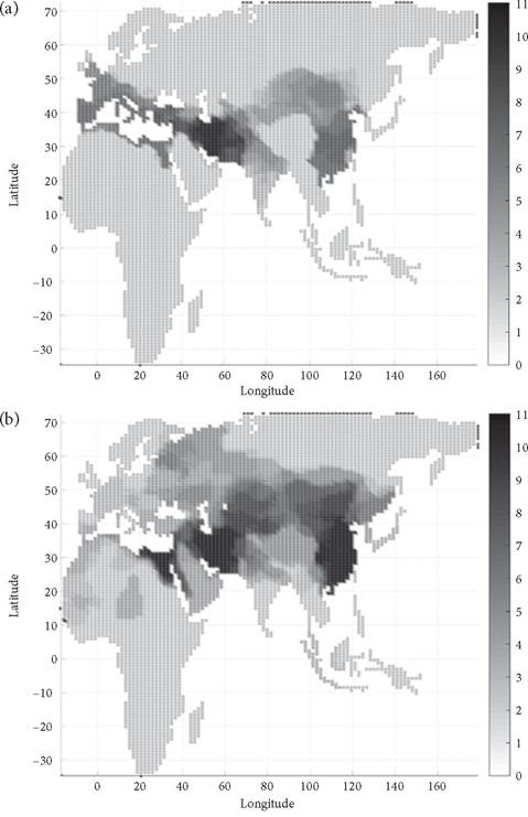
Figure 2.13. Probability of being part of large polities (>1,000,000 km2/1 century) at 100-year intervals, 600 bce to 1500 ce (probability rising from medium grey = low to black = high; light grey = zero). (a) 600 bce-400 ce. (b) 500-1500 ce.
Provided by James Bennett (University of Washington), on November 9, 2017, drawing on the data underlying Turchin, Currie, Turner, and Gavrilets 2013, 16386, who provide analogous heat maps for states of >100,000 km2.
fruitful, for instance by relating territorial or population size to empire duration or other variables such as spatial elongation or ecological diversity.[248] The relationship between the size of empires and their capital cities likewise invites systematic comparison.[249] Regularities in outcomes in different parts of the world might be traced back to shared influences ranging from climate change to social-economic and political-military interaction.[250] Much work remains to be done.
Bibliography
Barfield, T. J. 1989. The Perilous Frontier: Nomadic Empires and China, 221 bc to ad 1757.
Cambridge, MA.Chase-Dunn, C., A. Alvarez, and D. Pasciuti. 2005. “Power and Size: Urbanization and Empire Formation in World-Systems since the Bronze Age.” In C. Chase-Dunn and E. N. Anderson, eds., The Historical Evolution of World-Systems, 92-112. New York.
Cioffi-Revilla, C., J. D. Rogers, S. P. Wilcox, and J. Alterman. 2011. “Computing the Steppes: Data Analysis for Agent-Based Models of Polities in Inner Asia.” In U. Brosseder and B. K. Miller, eds., Xiongnu Archaeology: Multidisciplinary Perspectives of the First Steppe Empire in Inner Asia, 97-110. Bonn.
Cohen, J. E. 1995. How Many People Can the Earth Support? New York.
Etemad, B. 2007. Possessing the World: Taking the Measurements of Colonisation from the Eighteenth to the Twentieth Century. New York.
Hall, T. D., and P. Turchin. 2007. “Lessons from Population Ecology for World-Systems Analyses of Long-Distance Synchrony.” In A. Hornborg and C. Crumley, eds., The World System and the Earth System: Global Socioenvironmental Change and Sustainability since the Neolithic, 74-90. Walnut Creek, CA.
Hoffman, P. T. 2015. Why Did Europe Conquer the World? Princeton, NJ.
Lieberman, V. 2009. Strange Parallels: Southeast Asia in Global Context, c. 800-1830. Volume 2: Mainland Mirrors: Europe, Japan, China, South Asia, and the Islands. Cambridge.
McEvedy, C., and R. Jones. 1978. Atlas of World Population History. Harmondsworth, UK. Modelski, G. 2003. World Cities -3000 to 2000. Washington, DC.
Morris, I. 2010. Why the West Rules—For Now: The Patterns of History, and What They Reveal about the Future. New York.
Morris, I. 2013. The Measure of Civilization: How Social Development Decides the Fate of Nations. Princeton, NJ.
Motyl, A. J. 2001. Imperial Ends: The Decay, Collapse, and Revival of Empires. New York.
Scheidel, W 2019. Escape from Rome: The Failure of Empire and the Road to Prosperity. Princeton, NJ.
Taagepera, R. 1978a. “Size and Duration of Empires: Systematics of Size.” Social Science Research 7: 108-127.
Taagepera, R. 1978b. “Size and Duration of Empires: Growth-Decline Curves, 3000 to 600 b.c.” Social Science Research 7: 180-196.
Taagepera, R. 1979. “Size and Duration of Empires: Growth-Decline Curves, 600 b.c. to 600 a.d.” Social Science History 3: 115-138.
Taagepera, R. 1997. “Expansion and Contraction Patterns of Large Polities: Context for Russia.” International Studies Quarterly 41:475-504.
Turchin, P. 2003. Historical Dynamics: Why States Rise and Fall. Princeton, NJ.
Turchin, P. 2009. “A Theory for Formation of Large Empires.” Journal of Global History 4:191-217.
Turchin, P., J. M. Adams, and T. D. Hall. 2006. “East-West Orientation of Historical Empires and Modern States.” Journal of World-System Research 12:219-229.
Turchin, P., T. E. Currie, E. A. L. Turner, and S. Gavrilets. 2013. “War, Space, and the Evolution of Old World Complex Societies.” Proceedings of the National Academy of Sciences 110: 16384-16389.
More on the topic Distribution:
- The System’s Distribution of Losses
- EXPOSURE DISTRIBUTION
- Habitat suitability determines distribution and abundance
- The distribution and abundance patterns of species and populations vary in their spatial extent across the landscape.
- The Size and Distribution of the Movements
- Distribution and Abundance Patterns
- 9 Population Distribution and Abundance
- The physical environment can affect competition and ultimately the distribution of species
- CELL SOURCES AND TISSUE DISTRIBUTION
- Processes Important to Distribution and Abundance
- Oceanic circulation and the distribution and topography of continents influence global temperatures